
Articles | Volume 384
https://doi.org/10.5194/piahs-384-133-2021
© Author(s) 2021. This work is distributed under
the Creative Commons Attribution 4.0 License.
the Creative Commons Attribution 4.0 License.
https://doi.org/10.5194/piahs-384-133-2021
© Author(s) 2021. This work is distributed under
the Creative Commons Attribution 4.0 License.
the Creative Commons Attribution 4.0 License.
Pre-conference publication
| 
16 Nov 2021
Pre-conference publication |
| 16 Nov 2021
| 16 Nov 2021
Multi-criteria approaches to identify the shoreline retreat downstream of dams: the North African case
National Institute of Marine Sciences and Technologies, Laboratory of Marine Environment, University of Carthage, Tunis, Tunisia
Gil Mahé
HSM, UMR 5151, CNRS, Université Montpellier, IRD, 300, Avenue du
Professeur Emile Jeanbrau, 34090 Montpellier, France
Related authors
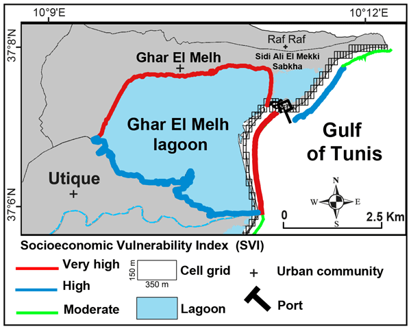
Abderraouf Hzami, Oula Amrouni, Essam Heggy, Gil Mahé, and Hechmi Missaoui
Proc. IAHS, 385, 377–385, https://doi.org/10.5194/piahs-385-377-2024, https://doi.org/10.5194/piahs-385-377-2024, 2024
Short summary
Short summary
Natural and anthropogenic causes of coastal environmental change are significantly linked to the sediment dynamics of the coastal lagoon on the North African coast, through both the variability of continental input and the coastal marine geomorphology. Temporal analysis of the aerial and orbital photogrammetry suggests that ~ 70 % of the Ghar El Melh coast.
Abderraouf Hzami, Oula Amrouni, Essam Heggy, Gil Mahé, and Hechmi Missaoui
Proc. IAHS, 385, 377–385, https://doi.org/10.5194/piahs-385-377-2024, https://doi.org/10.5194/piahs-385-377-2024, 2024
Short summary
Short summary
Natural and anthropogenic causes of coastal environmental change are significantly linked to the sediment dynamics of the coastal lagoon on the North African coast, through both the variability of continental input and the coastal marine geomorphology. Temporal analysis of the aerial and orbital photogrammetry suggests that ~ 70 % of the Ghar El Melh coast.
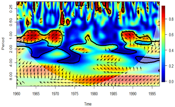
Marc Auriol Amalaman, Gil Mahé, Béh Ibrahim Diomande, Armand Zamblé Tra Bi, Nathalie Rouché, Zeineddine Nouaceur, and Benoit Laignel
Proc. IAHS, 385, 365–370, https://doi.org/10.5194/piahs-385-365-2024, https://doi.org/10.5194/piahs-385-365-2024, 2024
Short summary
Short summary
L’objectif de ce travail est d’analyser les liens entre les indices climatiques et la variabilité des séries de précipitations et de débits. La méthode a consisté à rechercher les changements survenus dans ces données à travers la variabilité du signal. Ainsi, au niveau de l’analyse interannuelle et saisonnière, le signal indique une forte oscillation marquée par une prédominance de la couleur rouge. L’utilisation de l’indice ENSO montre que le phénomène El-Niño impacte le débit et la pluie.
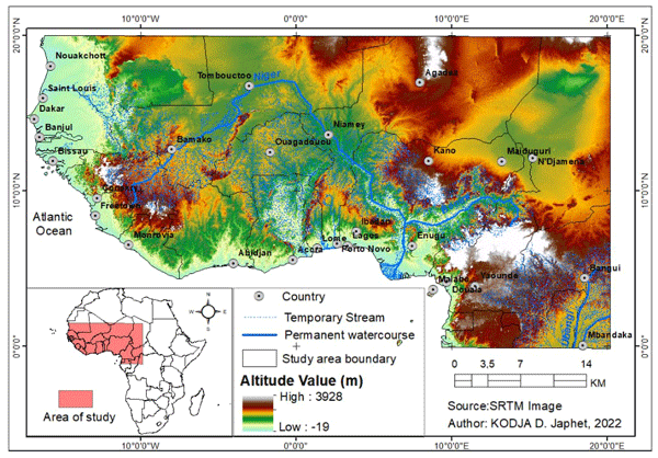
Domiho Japhet Kodja, Gandomè Mayeul Leger Davy Quenum, Houteta Djan'na Koubodana, Ernest Amoussou, Isaiah Sewanu Akoteyon, Arsène Sègla Josué Akognongbé, Mahougnon Fidèle Ahéhéhinnou Yêdo, Gil Mahé, Jean-Emmanuel Paturel, Expédit Wilfrid Vissin, and Constant Houndénou
Proc. IAHS, 385, 359–364, https://doi.org/10.5194/piahs-385-359-2024, https://doi.org/10.5194/piahs-385-359-2024, 2024
Short summary
Short summary
The results showed that there is an variability in the spatial distribution of extreme indices with an upward and downward trend of dry and wet rainfall periods in West Africa in both historical and projected periods. Thus, the results revealed that the spatio- temporal variability of extreme rainfall can have repercussions on the hydrological functioning of watersheds, water availability and water-dependent activities.
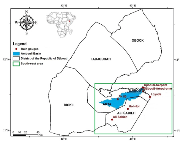
Golab Moussa Omar, Jean-Emmanuel Paturel, Christian Salles, Gil Mahé, Mohamed Jalludin, Frédéric Satgé, Mohamed Ismail Nour, and Abdillahi Hassan Hersi
Proc. IAHS, 385, 59–64, https://doi.org/10.5194/piahs-385-59-2024, https://doi.org/10.5194/piahs-385-59-2024, 2024
Short summary
Short summary
The Republic of Djibouti is a small country in the Horn of Africa and as with most regions of Africa, rain gauges are sparse. This study aims to compare at different time steps (annual, monthly, and daily) 15 rainfall estimation products (P-datasets) to 5 reference ground-based rainfall stations, over the period of 1980–1990. To classify the reliability of these products, several metrics were considered, the Kling Gupta Efficiency (KGE) and the Heidle Skills Scores (HSS at daily time step).
Ernest Amoussou, Félix Toundé Amoussou, Aymar Yaovi Bossa, Domiho Japhet Kodja, Henri Sourou Totin Vodounon, Constant Houndénou, Valérie Borrell Estupina, Jean-Emmanuel Paturel, Gil Mahé, Christophe Cudennec, and Michel Boko
Proc. IAHS, 385, 141–146, https://doi.org/10.5194/piahs-385-141-2024, https://doi.org/10.5194/piahs-385-141-2024, 2024
Short summary
Short summary
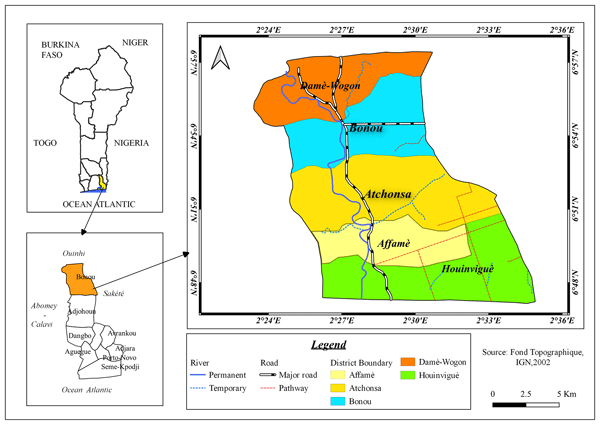
The objective is to assess the causes of exceptional floods in the Ouémé basin using the HEC-RAS model. The results of the calculation made it possible to characterize: the losses and damage due to human settlement on the banks and agricultural production in the flood zone, the flooded extent and the height of submersion depend on the return period, most of the Flood waters converge towards the west of the basin (low risk) and towards the east around the Damè-Wogon depression (high risk).
Rajae El Aoula, Gil Mahé, Nadia Mhammdi, Abdellatif Ezzahouani, Ilias Kacimi, and Kenza Khomsi
Proc. IAHS, 384, 163–168, https://doi.org/10.5194/piahs-384-163-2021, https://doi.org/10.5194/piahs-384-163-2021, 2021
Gil Mahé, Gamal Abdo, Ernest Amoussou, Telesphore Brou, Stephan Dietrich, Ahmed El Tayeb, Henny van Lanen, Mohamed Meddi, Anil Mishra, Didier Orange, Thi Phuong Quynh Le, Raphael Tshimanga, Patrick Valimba, Santiago Yepez, Andrew Ogilvie, and Oula Amrouni
Proc. IAHS, 384, 5–18, https://doi.org/10.5194/piahs-384-5-2021, https://doi.org/10.5194/piahs-384-5-2021, 2021
Short summary
Short summary
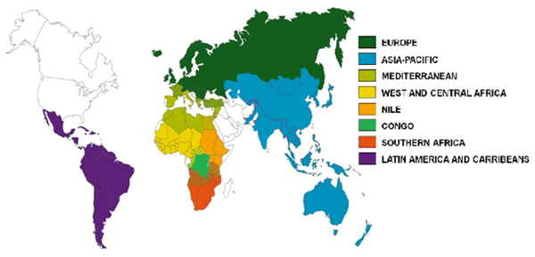
The FRIEND-Water program (FWP) is the oldest and the most transverse program within the UNESCO IHP. It allows large communities of hydrologists to collaborate across borders on common shared data and scientific topics, addressed through 8 large world regions. Research priorities evolve according to the projections given by the member States during the IHP councils. FWP further activities follow the IHP IX program with the support of the Montpellier UNESCO Category II Center ICIREWAD.

Valentin Brice Ebodé, Gil Mahé, and Ernest Amoussou
Proc. IAHS, 384, 247–253, https://doi.org/10.5194/piahs-384-247-2021, https://doi.org/10.5194/piahs-384-247-2021, 2021
Short summary
Short summary
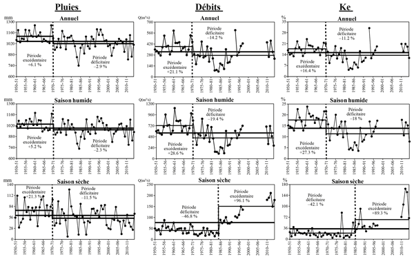
The objective of this article is to assess recent trends of hydroclimatic quantities in Ogooue basin in the context of climate change. For this, the rainfall and discharges data of this basin were analyzed using the Pettitt test. The results of this study reveal a statistically significant decrease in runoff that the Pettitt test situates in 1972–73, but nothing like that for rainfall at this same time scale.
Valentin Brice Ebodé, Gil Mahé, and Ernest Amoussou
Proc. IAHS, 384, 261–267, https://doi.org/10.5194/piahs-384-261-2021, https://doi.org/10.5194/piahs-384-261-2021, 2021
Short summary
Short summary
La sécheresse observée en Afrique tropicale vers la fin des années 1960, a également affecté le bassin de la Bénoué en Afrique centrale, avec une persistance remarquable qui s’est répercutée sur les écoulements. Les ruptures à la baisse ont été mises en évidence dans les séries hydropluviométriques de ce bassin au pas de temps annuel en 1970–71 (pluies) et 1971–72 (débits). Les déficits associés à cette rupture sont de −2,9 % pour les pluies et −14,2 % pour les débits.
Sakaros Bogning, Frédéric Frappart, Gil Mahé, Adrien Paris, Raphael Onguene, Fabien Blarel, Fernando Niño, Jacques Etame, and Jean-Jacques Braun
Proc. IAHS, 384, 181–186, https://doi.org/10.5194/piahs-384-181-2021, https://doi.org/10.5194/piahs-384-181-2021, 2021
Short summary
Short summary
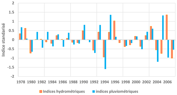
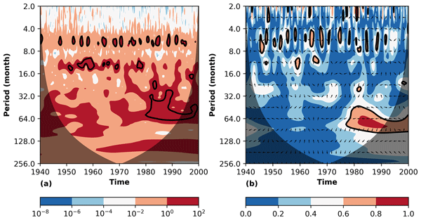
This paper investigates links between rainfall variability in the Ogooué River Basin (ORB) and El Niño Southern Oscillation (ENSO) in the Pacific Ocean. Recent hydroclimatology studies of the ORB and surrounding areas resulting in contrasting conclusions about links between rainfall variability and ENSO. Then, this work uses cross-wavelet and wavelet coherence analysis to highlight significant links between ENSO and rainfall in the ORB.
Ernest Amoussou, Gil Mahe, Oula Amrouni, Ansoumana Bodian, Christophe Cudennec, Stephan Dietrich, Domiho Japhet Kodja, and Expédit Wilfrid Vissin
Proc. IAHS, 384, 1–4, https://doi.org/10.5194/piahs-384-1-2021, https://doi.org/10.5194/piahs-384-1-2021, 2021
Short summary
Short summary
This short paper is the preface of the PIAHS volume of the IAHS/UNESCO FRIEND-Water conference of Cotonou in November 2021.
Golab Moussa Omar, Jean-Emmanuel Paturel, Christian Salles, Gil Mahé, and Mohamed Jalludin
Proc. IAHS, 384, 225–231, https://doi.org/10.5194/piahs-384-225-2021, https://doi.org/10.5194/piahs-384-225-2021, 2021
Short summary
Short summary
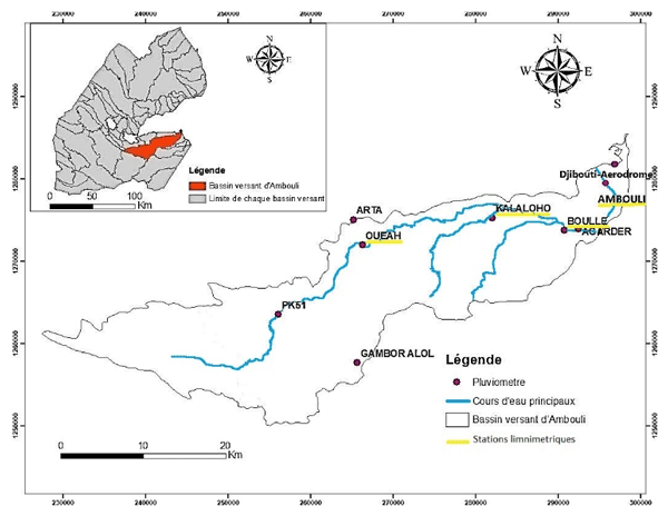
Le district de Djibouti est situé dans le bassin versant de l’Oued Ambouli qui par sa nappe aquifère procure la source principale d’alimentation en eau potable de la ville de Djibouti, mais est aussi à l’origine de crues rares et brèves avec de lourds bilans humains et économiques Le développement du district se traduit par une expansion urbaine et un développement des activités qui accentuent le risque inondation.
Cited articles
Amrouni, O., Sánchez, A., Khélifi, N., Benmoussa, T., Chiarella D.,
Mahé G., Abdeljaouad S., and McLaren P.: Sensitivity assessment of the
deltaic coast of Medjerda based on fine-grained sediment dynamics, Gulf of
Tunis, Western Mediterranean, J. Coast. Conserv., 23, 571–587,
https://doi.org/10.1007/s11852-019-00687-x, 2019a.
Amrouni, O., Hzami, A., and Heggy, E.: Photogrammetric assessment of shoreline
retreat in North Africa: anthropogenic and natural drivers, ISPRS J.
Photogramm., 157, 73–92,
https://doi.org/10.1016/j.isprsjprs.2019.09.001, 2019b.
Anthony, E. J.: Wave influence in the construction, shaping and destruction
of river deltas: A review, Mar. Geol., 361, 53–78,
https://doi.org/10.1016/j.margeo.2014.12.004, 2015.
Barusseau, J. P.: Evolution du plateau continental rochelais (golfe de
Gascogne) au cours du Pléistocène terminal et de l'Holocène. Les
processus actuels de la sédimentation, Thèse Es-Science,
Université de Bordeaux I, Bordeaux, France, 360 pp.,
1973.
Benmoussa, T., Amrouni, O., Dezileau, L., Mahé, G., and Abdeljaouad, S.: The sedimentological changes caused by human impact at the artificial channel of Medjerda-River (Coastal zone of Medjerda, Tunisia), Proc. IAHS, 377, 77–81, https://doi.org/10.5194/piahs-377-77-2018, 2018.
Benmoussa, T., Amrouni, O., Hzami, A., Dezileau, L., Mahe, G., Condomines M.,
and Saadi A.: Progradation and retrogradation of the Medjerda delta during
the 20th century (Tunisia, Western Mediterranean), Comptes Rendus
Geosciences, 351, 340–350, 2019.
Bush, D. M., and Young, R.: Coastal features and processes, in: Geological Monitoring, edited by: Young, R. and Norby, L., Geological Society of America, Boulder Colorado, pp. 47–67, available at: https://www.nps.gov/articles/geological-monitoring-of-coastal-features-and-processes.htm (last access: 19 October 2021), 2009.
Claude, J., Francillon, G., and Loyer, J. Y.: Les alluvions déposées par
l'Oued Medjerda lors de la crue exceptionnelle de mars 1973. Cahiers ORSTOM,
Ser. Hydrol. 14, 37e109, available at: http://horizon.documentation.ird.fr/exl-doc/pleins_textes/divers14-05/08532.pdf (last access: 19 October 2021), 1977.
COADS: Comprehensive Ocean-Atmosphere Data Set, Release 1, NOAA
Environmental Research Laboratories [data set], Climate Research Program, Boulder, CO,
268 pp., available at: https://shen.sdsu.edu/researchgroup/coads.htm (last access: 19 October 2021), 1964.
Coleman, J. M. and Roberts, H. H.: Deltaic coastal wetlands, in: Coastal Lowlands, edited by: van der
Linden, W. J. M., Cloetingh, S. A. P. L., Kaasschieter, J. P. K., van de Graaff,
W. J. E., Vandenberghe, J., and van der Gun, J. A. M.,
Springer, Dordrecht, the Netherlands, 1989.
Cowell, P. and Thom, B.: Morphodynamics of coastal evolution, in: Coastal Evolution: Late Quaternary Shoreline Morphodynamics, edited by: Plassche, O., Carter, R., and Woodroffe, C., Cambridge University Press, Cambridge, UK, pp. 33–86, https://doi.org/10.1017/CBO9780511564420.004, 1995.
Delile, H., Abichou, A., Gadhoum, A., Goiran, J. P., Pleuger, E., Monchambert, J.
Y., Wilson, A., Fentress, E., Quinn, J., Ben Jerbania, I., and Ghozzi, F.: The
Geoarchaeology of Utica, Tunisia: the paleogeography of the Mejerda Delta
and hypotheses concerning the location of the Ancient Harbor,
Geoarchaeology, 30, 291–306,
https://doi.org/10.1002/gea.21514, 2015.
El Arrim, A.: Étude d'impact de la dynamique sédimentaire sur la
stabilité du littoral du Golfe de Tunis, Doctorat de spécialité, Unversité de Tunis El Manar, Tunis, Tunisia,
203 pp., 1996.
Folk, R. L. and Ward, W. C.: Brazos river bar: a study in the signification
of grain size parameters, J. Sediment. Petrol., 27, 3–26,
1957.
Hzami, A., Amrouni, O., Romanescu, G., Constantin Stoleriu, C., Mihu-Pintilie, A., and Saâdi, A.: Satellite images survey for the identification of the coastal sedimentary system changes and associated vulnerability along the western bay of the Gulf of Tunis (northern Africa), Proc. IAHS, 377, 83–89, https://doi.org/10.5194/piahs-377-83-2018, 2018.
Hzami, A., Heggy, E., Amrouni, O., Mahe, G., Manaan, M., and Abdeljaouad, S.:
Alarming coastal vulnerability of the deltaic and sandy beaches of North
Africa, Sci. Rep., 11, 2320, https://doi.org/10.1038/s41598-020-77926-x, 2021.
INM: Tunisian National Institute of Meteorology, INM, Data-base, available at: http://www.meteo.tn/htmlfr/accueil.php (last access: 19 October 2021), 2019.
Kotti, F., Mahe, G., Habaieb, H., Dieulin, C., and Calvez, R.: Etude des pluies et
des débits sur le bassin versant de la Medjerda, Tunisie, Bulletin de
l'Institut Scientifique, 38, 19–28, 2016.
Kotti, F., Dezileau, L., Mahe, G., Habaieb, H., Benabdallah, S., Bentkaya, M.,
Calvez, R., and Dieulin, C.: The impact of dams and climate on the evolution of
the sediment loads to the sea by the Medjerda River using a
paleo-hydrological approach, J. Afr. Earth Sci., 142,
226–233, https://doi.org/10.1016/j.jafrearsci.2017.10.003, 2018a.
Kotti, F., Dezileau, L., Mahé, G., Habaieb, H., Bentkaya, M., Dieulin, C., and Amrouni, O.: Etude de l'impact des barrages sur la réduction des transports sédimentaires jusqu'à la mer par approche paléohydrologique dans la basse vallée de la Medjerda, Proc. IAHS, 377, 67–76, https://doi.org/10.5194/piahs-377-67-2018, 2018b.
Le Roux, J. P.: An alternative approach to the identification of the end
sediment transport paths based on grain size trends, Sediment. Geol., 94, 97–107, 1994.
Levoy, F.: Morphodynamique des plages sableuses et trait de côte à
différentes échelles spatio-temporelles, vol. I., Mémoire
d'habilitation, UFR des Sciences de la Terre et de l'Aménagement
Régional, Université de Caen Basse-Normandie, Caen, France, 150 pp., 2000.
Mazzoni, A, Heggy, E., and Scabbia, G.: Forecasting water budget deficits and
groundwater depletion in the main fossil aquifer systems in North Africa and
the Arabian Peninsula, Global Environmental Change, 53, 157–173, 2018.
Paskoff, R. and Sanlaville, P.: Les côtes de la Tunisie. Variations du
niveau marin depuis le Tyrrhénien, Coll. Maison Orient Medit., 14,
Sér. Géogr. et Préhist., 192 pp., available at: https://www.persee.fr/issue/mom_0243-2439_1983_mon_14_1 (last access: 19 October 2021), 1983.
Pirazzoli, P. A.: Secular trends of relative sea level (RSL) changes
indicated by tide-gauge records, J. Coastal Res., 1, 1–26, available at: http://www.jstor.org/stable/44863318 (last access: 19 October 2021), 1986.
Pleuger, E., Goiran, J.-P., Mazzini, I., Delile, H. Abichou, A., Gadhoum, A.,
Djerbi, H., Piotrowska, N., Wilson, A., Fentress, E., Ben Jerbania, I., and Fagel,
N.: Paleogeographical and paleoenvirenmental reconstitution of the Medjerda
delta (Tunisia) during the Holocene, Quaternary Sci. Rev., 220,
263–178, 2019.
Soussi, N. and BenMammou, A.: Les apports solides en suspension de la
Medjerda-Tunisie, 2ème congrès de sédimentologie, Paris, 1989.
Syvitski, P. M. and Kettner, A.: Sediment flux and the Anthropocene, Phil.
Trans. R. Soc. A, 369, 957e975, available at: https://www.jstor.org/stable/41061709 (last access: 19 October 2021), 2011.
Thieler, E. R. and Danforth, W.: Historical Shoreline Mapping (II):
Application of the Digital Shoreline Mapping and Analysis System (DSMS/DSAS) to Shoreline Change Mapping in Puerto Rico, J. Coastal Res., 10, 600–620, available at: https://pubs.er.usgs.gov/publication/70135638 (last access: 19 October 2021),
1994.
Tramblay, Y., El Adlouni, S., and Servat, E.: Trends and variability in extreme precipitation indices over Maghreb countries, Nat. Hazards Earth Syst. Sci., 13, 3235–3248, https://doi.org/10.5194/nhess-13-3235-2013, 2013.
Short summary
Our multidisciplinary study reveals an alarming trend of beach retreat reaching −20 m ± 0.15 m yr−1 after the human-induced change over the hydrological network where ~ 50 % of sediment discharge has been trapped upstream the dams. Accros the semi arid north African coasts, the rapid shoreline retreat is due to the decreasing of sediment fluvial discharge trapped by the dam infrastrcture.
Our multidisciplinary study reveals an alarming trend of beach retreat reaching...


