the Creative Commons Attribution 4.0 License.
the Creative Commons Attribution 4.0 License.
 | 18 Apr 2024
Use of the HEC RAS model for the analysis of exceptional floods in the Ouémé basin
Ernest Amoussou
Félix Toundé Amoussou
Aymar Yaovi Bossa
Domiho Japhet Kodja
Henri Sourou Totin Vodounon
Constant Houndénou
Valérie Borrell Estupina
Jean-Emmanuel Paturel
Gil Mahé
Christophe Cudennec
Michel Boko
The Ouémé River basin extends over almost half of Benin's territory, entirely located in a humid tropical climate. This river system includes a deltaic zone (delta of the Ouémé) known for its high agricultural potential and thus subject to a socio-economic development agenda. The Ouémé delta is facing recurrent floods that maintain rural agricultural population into a retrograding crisis with significant damages such as losses of properties. The objective of this study is to improve decision-making in the Ouémé basin through the simulation of exceptional floods using the HEC-RAS model.
The HEC RAS model is a conceptual model, which works through mathematical and physical formulas to implement environmental phenomena for forecasting, understanding and analysis purposes. The model inputs used are basin GIS data, hydro-meteorological data, characteristics of existing hydraulic structures, etc. The targeted outputs include 1D/2D/3D view plans with support of satellite images, tables, graphs and curves. It is worth mentioning that the model provides outputs compatible with other tools, such as civil engineering (Civil 3D, Revit, Infraworks, etc.) and GIS, that help to expand the valorization fields.
The implementation of the model in the Ouémé basin has made it possible to note: (i) that the recurring effect of losses and damages is justified by the settlement of the population on the river banks; (ii) that there is an important agricultural production in areas of high flood risk; (iii) that depending on the occurrence of the phenomenon, the flooded extent and the height of submersion remains variable, and more important for extreme flooding; (iv) about 12.07 % occurrence of river flood against 13.24 % for flash flood at a return period of 30 years. Moreover, it is very relevant to note that most of flood waters converge to the western part of the basin (an area with a low risk of flooding, stretched over 63.68 km2) and to the eastern part around the Damè-Wogon depression (an area at high risk of flooding, stretched over 10.49 km2).
- Article
(4578 KB) - Full-text XML
- BibTeX
- EndNote


Flood risk; flood damage estimation; Ouémé River Basin; HEC-RAS model; exceptional flood
Water, at the heart of any sustainable development process, is also a source of disasters for most human communities and ecosystems. These disasters are increasing day by day, an effect of global warming that the planet is currently experiencing. These hydroclimatic consequences result in exceptional floods and extreme droughts (IPCC, 2007; Marengo and Espinoza, 2015). A natural hazard for human society and its ecosystem that is difficult to predict but can be anticipated to mitigate economic, health and other losses (FAO, 2008; Shen et al., 2007). Benin, a West African country is not spared, like the most watered basins in the golf of guinea (Degan et al., 2019; Kodja, 2018; Mahé, 2006). However, Bonou district, is very heavily watered during the monsoon period (Bani, 2006), experiences periodic exceptional flooding situations which plunge a population with a low standard of living into a very unpleasant state. Moreover, with this potential for sustainable agricultural development and poverty reduction according to the Millenium Municipality Project (PCM, 2015), it is urgent to this end, a flood management plan to better take advantage of these nationally recognized assets. It is in this preventive clause that this research entitled, use of the HEC RAS model for the analysis of exceptional floods in the Ouémé basin in the Bonou district is organized. It will make it possible to show the causes of the losses and damages; and propose long-term preventive measures to minimize the damage faced with the occurrence of exceptional floods in the locality.
2.1 Modeling exceptional floods
An exceptional flood is a phenomenon deemed to be rare and of extreme intensity but whose occurrence is more or less unpredictable on a temporal scale (FAO, 2008). It is often accompanied by such extraordinary damage when vulnerable to a high intensity downpour (Amoussou et al., 2014). However, with modeling using physics, mathematics and computer tools, it is possible to understand the causes and effects of a phenomenon. Thus, the modeling of exceptional floods on the district used statistical hydrology tools to determine the exceptional events characterizing the district; because hypothetically it is obvious that the extreme values are at the origin of floods. The surface hydraulic modeling tool HEC RAS is used to model the exceptional floods for different return periods, because it is likely that the extent of the flooded areas is a function of the return period. The susceptibility of losses and damages is assessed through mapping since land use is a factor reacting to remarkable losses and damages during floods.
2.2 Characterization of extreme events in Bonou district
Bonou district (Fig. 1) is located in the department of Ouémé in the south-east of the Republic of Benin between 6° and 6° N of the Northern Latitude and between 2° and 2° E of East Longitude.
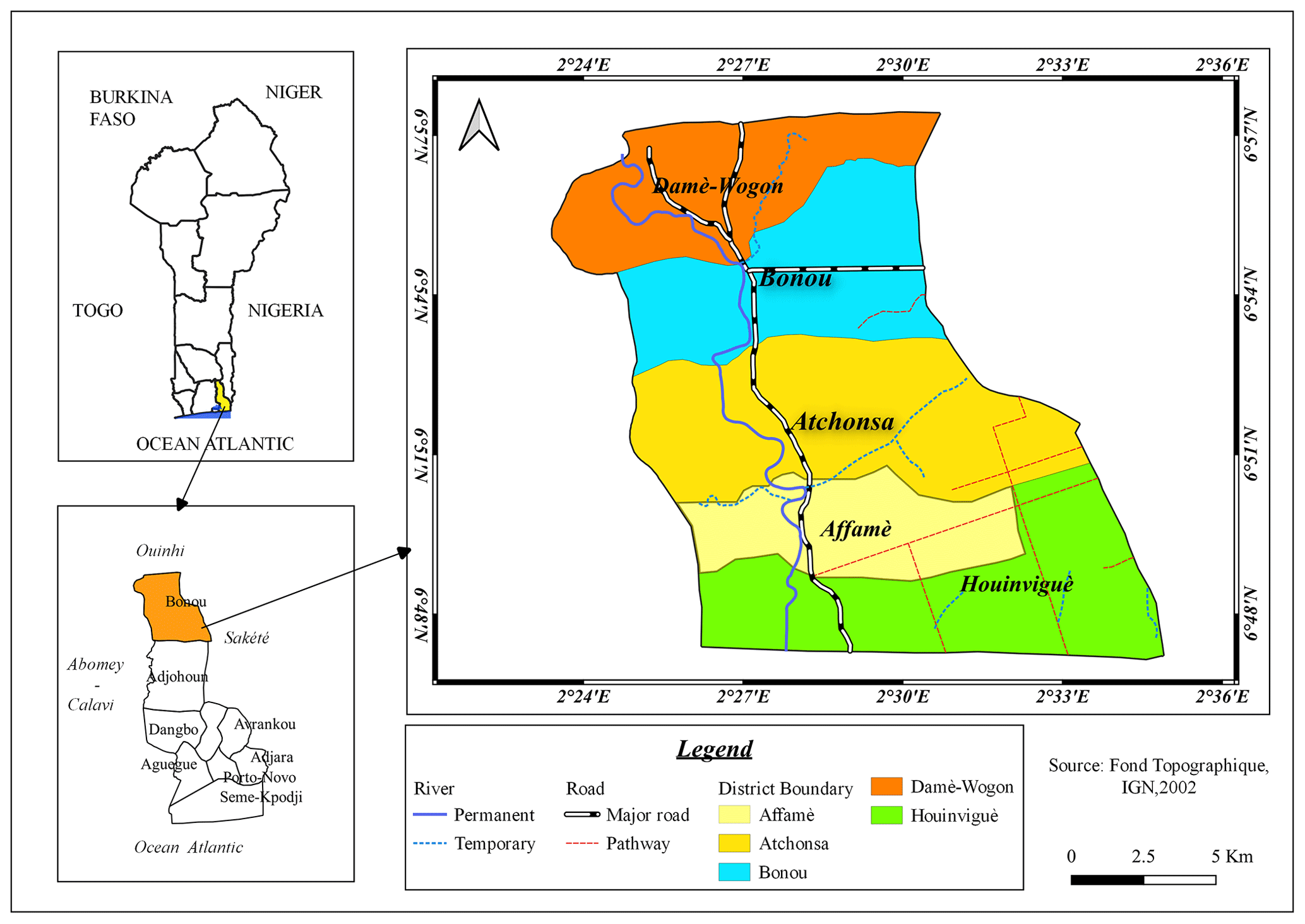
Figure 1Administrative map of the study area.
The average annual rainfall is 1121 mm. It is distributed on:
-
two (02) rainy seasons from April to July and from September to August when rain floods occur especially from June to July.
-
Two (02) dry seasons from December to March and from July to August when a river flood is observed by the overflow of the Ouémé River during the month of September with the contribution of rainfall from the North of the country (Totin et al., 2016).
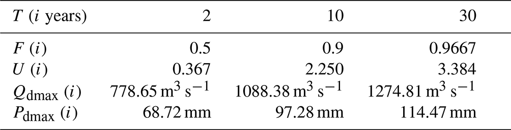
Indeed, the characterization of the exceptional events of the district will take into account the runoff aspect (river flood) and the rainfall aspect (rain flood). The determination of the peak flows of the Ouémé River and the estimation of maximum rainfall are made following the statistical laws of GEV (Generalized Extreme Values) including the Gumbel law (Gradex method) being the best suited in our region (Lawin et al., 2011). Base on Gumbel equation
and the Hazen formula
the maximum daily rainfall and flow are estimated for return period of T=2, 10 and 30 years (Table 1). It shows that there is a 50 % chance each year of recording flows of around 778.67 m3 s−1 against once in thirty years (approximately 3.33 %) for a flow of 1274.81 m3 s−1 (respectively 114.74 mm of rainfall).
Table 1Results of the estimation of flow and precipitation values for the return period of 2, 10 and 30 years.
2.3 Modeling of extreme floods by HEC RAS at Bonou
The modeling of extreme floods by HEC RAS results in a spatialized hydraulic implementation of the values obtained by characterizing the extreme events observables in the district. The output will map, analyze and assess flood risk. Beyond the Digital Elevation Model (DEM, resolution = 30 m × 30 m) of the district, the estimated Pdmax and Qdmax values, the boundary conditions (precipitation = Pdmax, upstream flow = Qdmax, downstream = normal depth), the Manning coefficient (Table 2) according to land use, the hydraulic model is computed.
Table 2Land cover and manning coefficient.
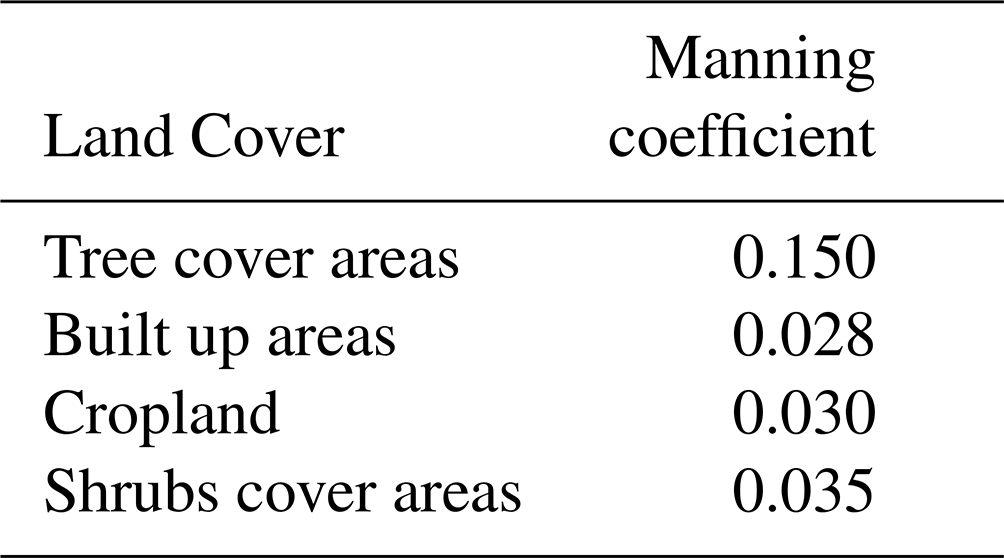
(Source: U.S. Army Corps of Engineers, HEC5, Hydraulic Reference Manuel, CPD-69, 3–16 p., 2016).
However, a study focused on the flood hydrograph of the catastrophic year 2010 (GFDRR, 2011), like one of the recent possible considerations. Indeed, the daily flows of 2010 in Bonou shows an annual maximum fluctuating around 1026 m3 s−1 which remains well above the estimated biennial flow (778.65 m3 s−1), closer to the ten-year flow (1088.38 m3 s−1) and distant from the one in their thirties.
From this hydrograph, it has been shown that the biennial flood lasts about 68 d and about 20 d for the ten-year and thirty-year ones (Fig. 2). These daily intervals are considered for the river simulation and a distributed hyetograph of the Pdmax value on 1 h for the rainfall.
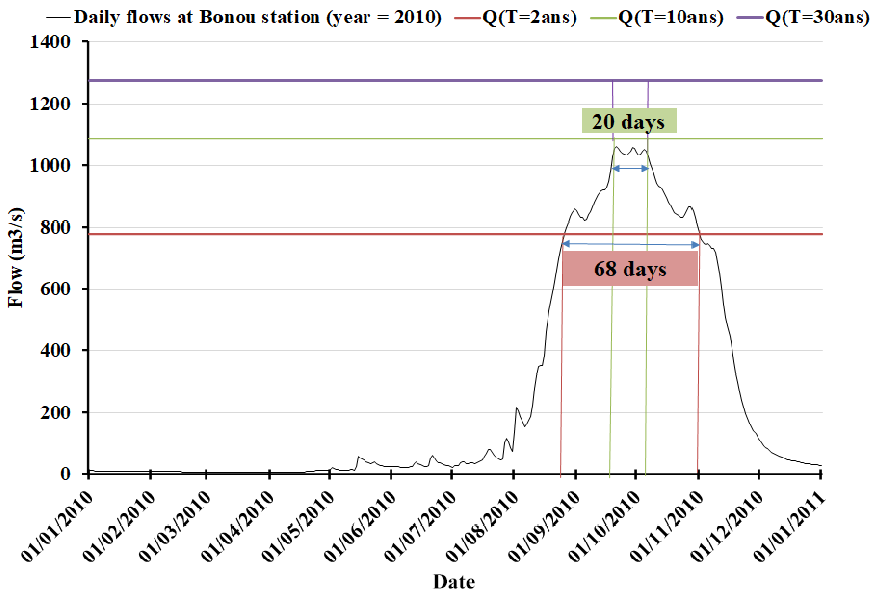
Figure 2Stationarity of daily flows at the Bonou station in 2010 (Source: DG-Eau, 2012).
3.1 Modeling
The results show us the following:
The compilation of observations from the results can be summarized as follows (Tables 3, 4):
Ultimately, it is very remarkable that the waters are concentrated much further west of the river and upstream to the east in the Damè-Wogon depression.
Table 3Statistics on modeling results for River flood (Fig. S3 – River flood).
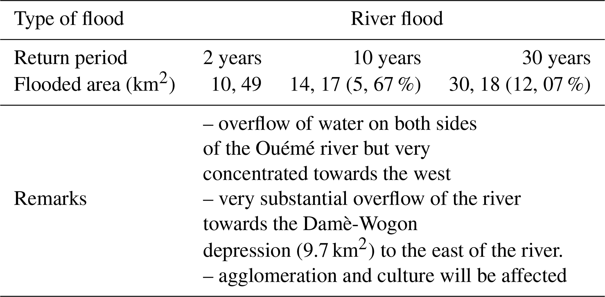
Table 4Statistics on modeling results for Rain flood (Fig. S3 – Rain flood).
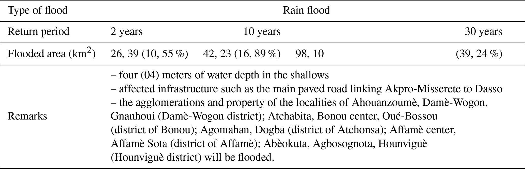
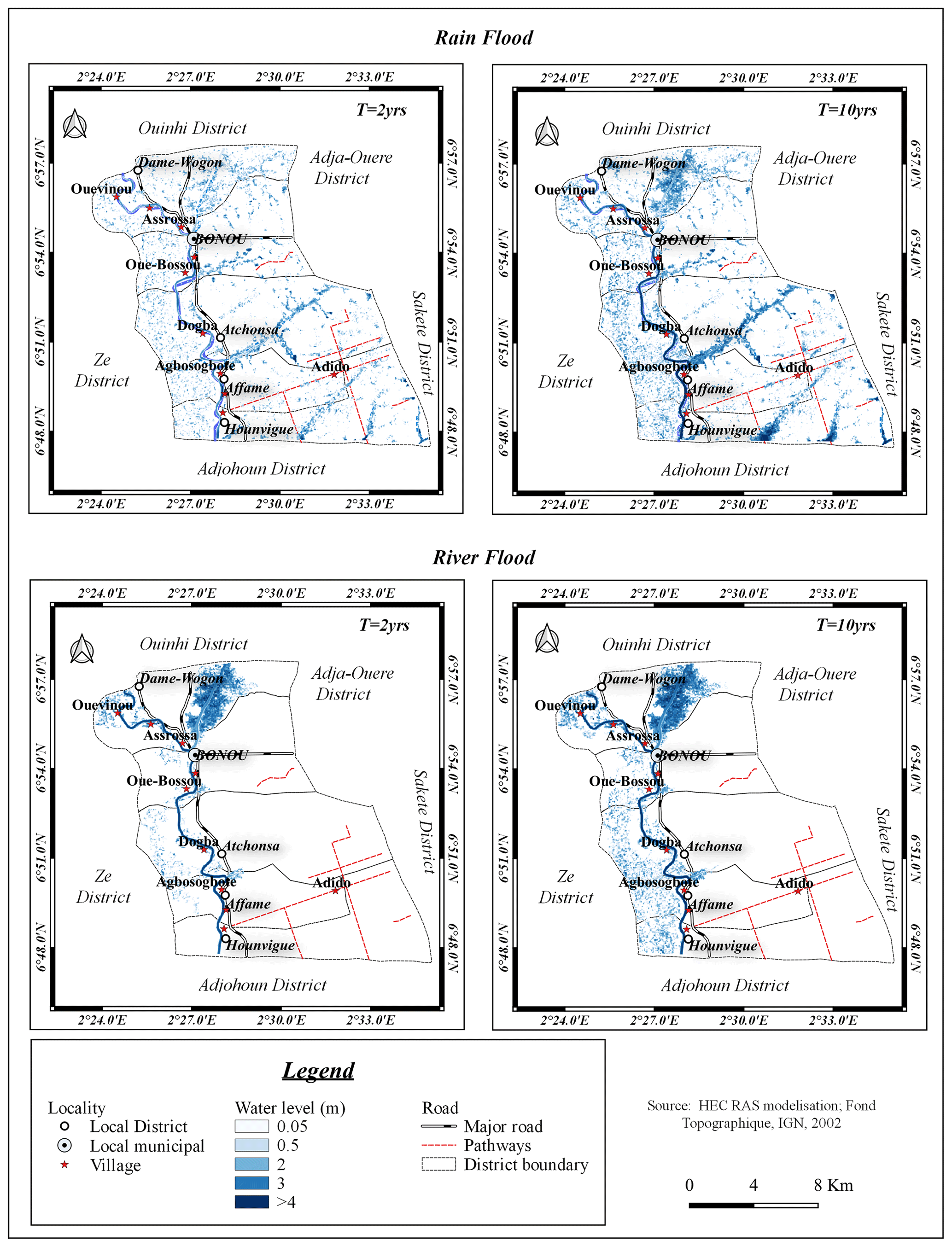
Figure 3River and rain flooding map (T=2, 10 years).
3.2 Susceptibility of losses and damages in the district
Following the land cover map (ESA Sentinel 2A 2016), from which the spatial distribution map of agglomerations and crops in the district are extracted. From the latter, we were able to highlight the relativity of the damage linked to extreme floods. This leads to major conclusions such as:
-
settlement of the population along the banks of the Ouémé River,
-
a preponderant domination of agricultural activities in areas of recurrent flooding (western part of the river) and depression (Damè-Wogon).
3.3 Delimitation of areas at risk of flooding
The compilation of the various results of the modeling of extreme floods and the susceptibility of losses and damages in the Bonou district makes it possible to generate a map (Fig. 4) of the flood zone at different levels of flood risk.
Indeed, based on the water level and land uses, we distinguish mainly two zones; an unwatered area (104.32 km2) and an area at risk of flooding (145.68 km2). However, we can divide into three risks flooding levels (river and rain) in the district, like:
-
high risk (20.13 km2): Ahouanzoumè, Asrossa and Gnanhoui-zoumè,
-
medium risk (63.68 km2): Atchabita, Affamè centre, Abèokuta, Avlankamè, Agbosota, Dogba, Ouvienou and Oué-bossou.
-
low risk (61.87 km2): rest of the localities. Most crops such as: maize, tomato, cassava, pepper, etc. are grown in high and medium risk areas; a cause of losses recorded during floods.
Following these different results, some solutions have been proposed in a territorial management context. Preventive measures not vigorously studied, but serving as a front were mentioned.
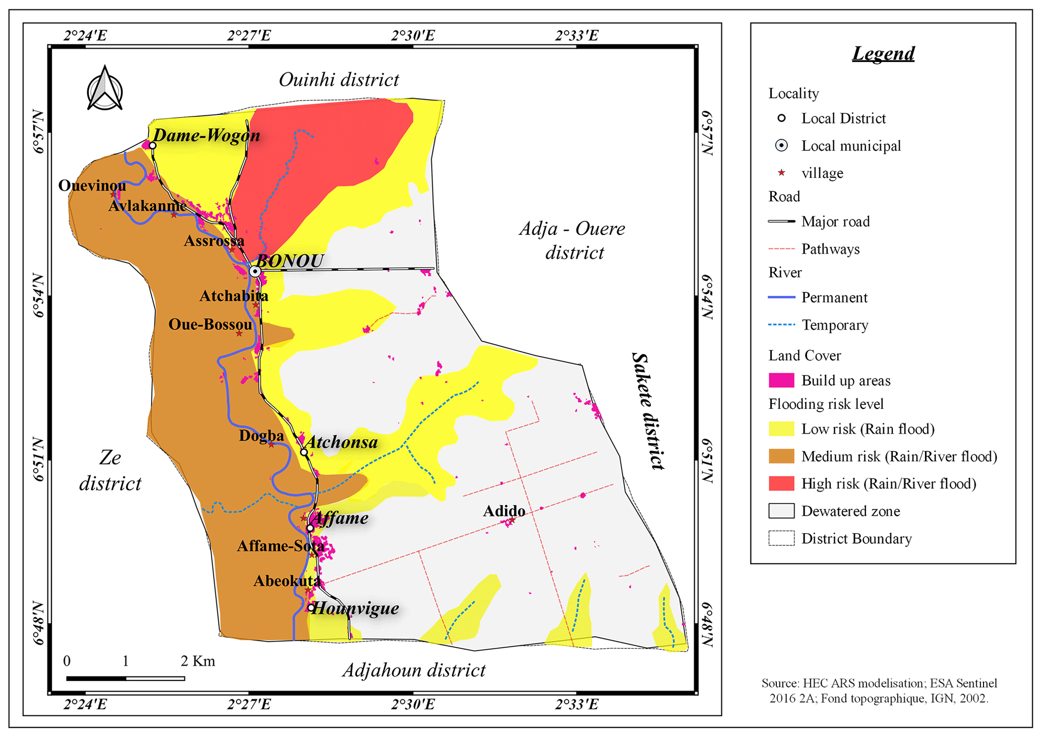
Figure 4Map of areas at risk of flooding in Bonou district (Source: HEC RAS, modelisation, 2020; ESA, Sentinel 2A, 2016).
Base on those results, for human security and agricultural production, we suggest:
4.1 a. better territorial occupation
-
leave the middle riverbed, a natural water habitat,
-
practice perennial or non-vulnerable crops to low propagation wave floods in high-risk areas: palm groves, teak, mahogany, etc. allowing the flood hydrograph to be rolled downstream,
-
Cultivate food crops in low-risk and unwatered areas.
4.2 b. artificial lake creation (Fig. 5)
A preliminary study has shown us that an artificial lake will retain the excess water capable of flooding the population and crops. Well placed in the depression of Damé-wogon, it is located upstream of the cultures of the district. A simulation study confirms the effectiveness of its role of protection and rolling of river flood waves. This is a clearing of a side of 5 m in direct communication with the middle bed of the river.
We notice;
-
A probable optimal protection of crops and agglomerations for floods of
-
years
-
a probable extension of the duration of the cropping seasons during the recession by exploitation of the stored water.
-
a limitation of the storable volume in the cuvette for T>=10 years.
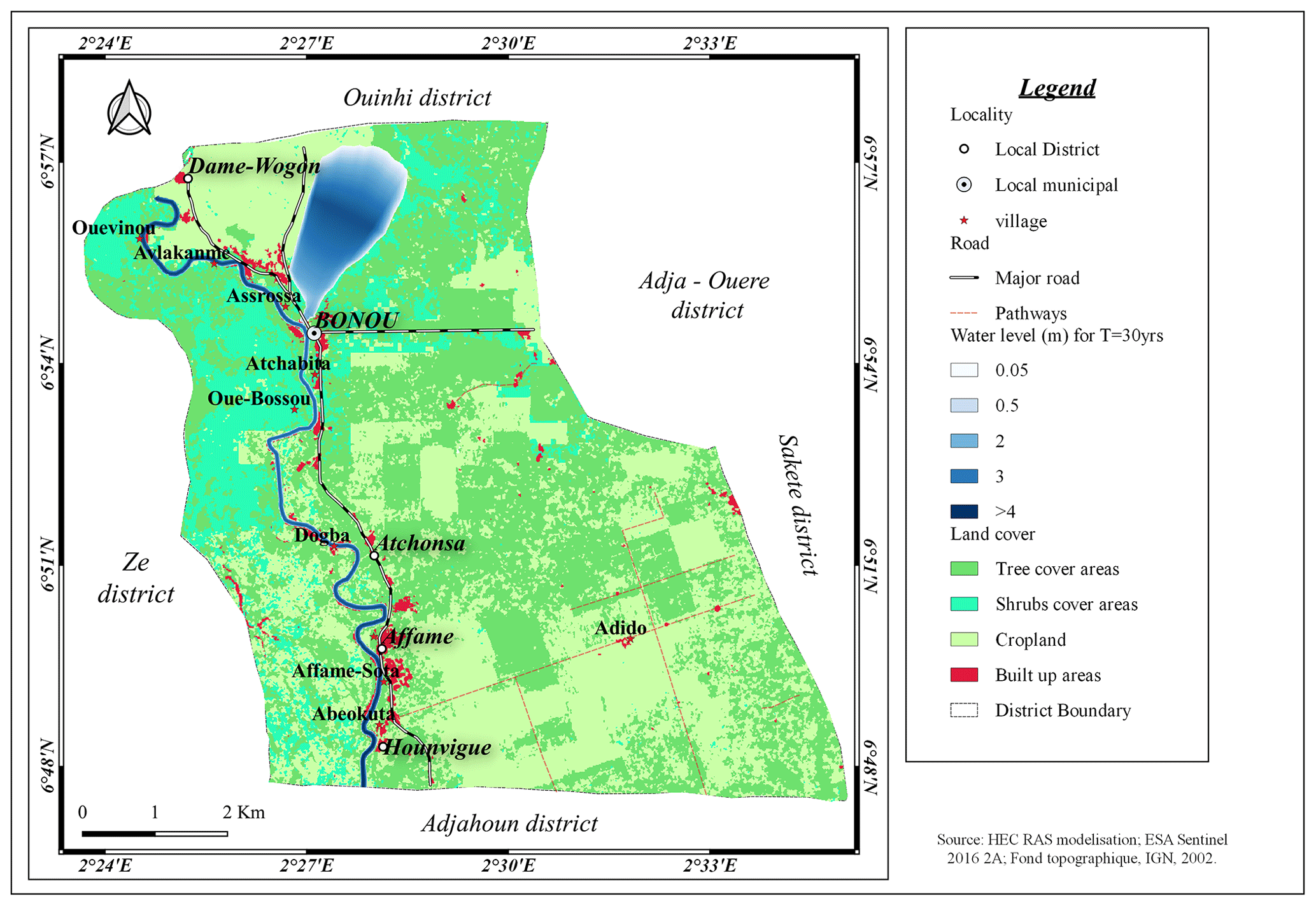
Figure 5Results of an exceptional flood of T=30 years of 1 d at constant flow (Source: HEC RAS, modelisation, 2020; ESA, Sentinel 2A, 2016).
4.3 c. Modification of the section of the watercourse
The activity of dredging the section of the river will widen and increase the draft. Therefore, increase the volume of water to be evacuated from the district.
4.4 d. Installation of channel networks
To limit the damage linked to rain floods in the fields, networks of meshed channels and directly connected to the middle bed of the river can be envisaged. They will make it possible to evacuate the water from the fields to the dredging river or vice versa.
This work on the modeling of exceptional floods in Bonou district is essentially based on the various tools and data from the cartography, on hydroclimatic data and on the use of a hydraulic model. The methodology is based on the use of various sources of information, statistical analyses, cartography and hydraulic modelling. It obviously made it possible to understand that the extreme values of flow and rainfall are at the origin of the floods. But specifically, it is the persistence of fluctuations in these values over time that amplifies this cause.
From this study, it is noted that the extent of the areas flooded during a rainfall flooding exceeds the river flooding. The extent of these zones decreases with the decrease of the return period. This confirms the variation of floodplains according to the type of flood and according to the duration of occurrence.
The occupation of floodplains, the banks of the river and the cultivation of crops in the plains are the main causes that intensify the losses and damage observed during floods. Hence, the occupation of the land is a factor at the base of the losses and damages in the district. Moreover, the enhancement of this work requires the establishment of guidelines to manage floods. Among so many recommendations, we suggest for the safety of goods and services: the transformation into an artificial lake/temporary reservoir area, the plain of Dame-wogon; to encourage the activity of extracting sand from the bed of the Ouémé River and the establishment of channel network systems.
However, the best way to stay safe from river flooding is to settle in the eastern part of the river, far from the bank.
No data sets were used in this article.
Conducted this research: EA. Conceptualization: EA, FTA, AYB, DJK and HSTV. Methodology and modelling and data processing: EA, FTA, AYB, DJK, HSTV and CH. Writing-Original Draft Preparation: EA, FTA, AYB, DJK, HSTV, CH, J-EP and GM. Writing-Review and Editing: VBE, J-EP, GM, CC and MB. All authors have read and agreed to the published version of the manuscript.
At least one of the (co-)authors is a guest member of the editorial board of Proceedings of IAHS for the special issue “IAHS2022 – Hydrological sciences in the Anthropocene: Variability and change across space, time, extremes, and interfaces”. The peer-review process was guided by an independent editor, and the authors also have no other competing interests to declare.
Publisher’s note: Copernicus Publications remains neutral with regard to jurisdictional claims in published maps and institutional affiliations.
This article is part of the special issue “IAHS2022 – Hydrological sciences in the Anthropocene: Variability and change across space, time, extremes, and interfaces”. It is a result of the XIth Scientific Assembly of the International Association of Hydrological Sciences (IAHS 2022), Montpellier, France, 29 May–3 June 2022.
This paper was edited by Salvatore Grimaldi and reviewed by two anonymous referees.
Amoussou, E., Camberlin, P., Totin Vodounon, S. H., Tramblay, Y., Houndenou, C., Mahé, G., and Boko, M.: Evolution des précipitations extrêmes dans le bassin-versant du Mono (Bénin – Togo) en contexte de la variabilité et de changement climatique, in: Climat: Système & Interactions 27éme Colloque de l'Association Internationale de Climatologie, Dijon, France, 331–337, ISBN 978-2-907696-20-3, 2014.
Bani, G.: Monographie de la commune de Bonou, Afrique conseil, 25 p., https://docplayer.fr/79623514-Monographie (last access: March 2019), 2006.
Degan, B. A., Gbaguidi, V., Karambiri, H., Alamou, E., and Afouda, A. A.: Impact de la variabilité climatique sur l’évolution des crues du fleuve Ouémé au Bénin de 1952 à 2011, EPAC/UAC, Benin, 204 p., https://biblionumeric.epac-uac.org:9443/jspui/handle/123456789/2216 (last access: March 2019), 2019.
DG-Eau: Carte hydrogéologique du Bénin: Echelle 1: 500000, Rapport de recherche sur la carte hydrogéologique du Bénin, Ministère des Mines, de l'Energie et de l'Eau, République de Bénin, 2012.
FAO: Climate change and Food security: a Framework for Action, Rome, conference de Bali, 78 p., https://www.fao.org/3/au035e/au035e.pdf (last access: March 2019), 2008.
Fatma, C. S. E.: Délimitation des zones inondables par l'utilisation combiné du logiciel HEC-RAS et HEC GEORAS cas du centre “AIN Jemaa”, Master Sciences et Techniques, 97 p., http://www.secheresse.info/spip.php?article72316 (last access: July 2019), 2013.
GFDRR: Rapport d'Evaluation des Besoins Post Catastrophiques liées à l'inondation, Bénin, 75 p., https://www.gfdrr.org/sites/default/files/publication/pda-2011-benin-fr.pdf (last access: March 2019), 2010.
HEC-RAS River Analysis System: 2D Modeling user's manual, US Army Corps of Engineers, Institute for Water Ressources Hydrologic Engineering Center, CPD-68A, 171 p., https://www.hec.usace.army.mil/software/hec-ras/documentation/HEC-RAS 5.0 Users Manual.pdf (last access: 25 August 2019), 2016.
IPCC: Changements climatiques, rapport de synthèse, 103 p., https://www.ipcc.ch/site/assets/uploads/2018/02/ar4_syr_fr.pdf (last access: April 2019), 2007.
Kodja, J. D.: Indicateurs des événements hydroclimatiques extrêmes dans le bassin-versant de l'Ouémé à l'exutoire de Bonou en Afrique de l'Ouest, Thèse de Doctorat, Université de Montpellier, 214 p., https://tel.archives-ouvertes.fr/tel-01869842 (last access: July 2019), 2018.
Lawin, A. E., Afouda, A., and Lebel, T.: Analyse de la variabilité du régime pluviométrique dans la région agricole d'Ina au Bénin, European Journal of Scientific Rechearch, ISSN 1450-216 X Vol.50, No.3, 425–439, https://www.scirp.org/(S(lz5mqp453edsnp55rrgjct55))/reference/referencespapers.aspx?referenceid=2107220 (last access: Febuary 2020), 2011.
Mahé, G.: Variabilité pluie-Débit en Afrique de l'Ouest et Centrale au 20éme siècle: changements hydroclimatiques, occupation du sol et modélisation hydrologique, université des Sciences et Techniques Montpellier, Ecole Doctorale 148 Terre, Eau, Espace, 161 p., https://horizon.documentation.ird.fr/exl-doc/pleins_textes/divers11-03/010043107.pdf (last access: January 2021), 2006.
Marengo, A. J. and Espinoza, J. C.: Extreme seasonal droughts and floods in Amazonia: causes, trends and impacts, Int. J. Climatol., 36, 1033–1050, https://doi.org/10.1002/joc.4420, 2015.
Pomerleau, J.: Changements climatiques et sécurité en Afrique, centre universitaire de formation en environnement, Université de Sherbrooke, 99 p., https://savoirs.usherbrooke.ca/bitstream/handle/11143/7402/cufe_Pomerleau_essai97.pdf?sequence=1&isAllowed=y (last access: March 2018), 2009.
Projet Commune du Millénaire de Bonou pour un Développement Durable (PCM-Bonou), 92 p., https://bj.chm-cbd.net/sites/bj/files/2022-09/Projet (last access: 14 May 2019), 2015.
Shen, C., Wang, WC., Hao, Z., and Gong, W.: Exceptional drought events over eastern China during the last five centuries, Clim. Change, 85, 453–471, https://doi.org/10.1007/s10584-007-9283-y, 2007.
Totin, V. S., Amoussou, E., Odoulami, L., Boko, M., and Blivi, B.: Seuils pluviométriques des niveaux de risques d'inondation dans le bassin de l'Ouémé au Bénin, XXIXème colloque de l'Association de Climatologie, Lausanne – Besançon, 369–374, http://www.climato.be/aic/colloques/LausanneBesancon (last access: 18 April 2019), 2016.
U.S. Army Corps of Engineers: HEC5, Hydraulic Reference Manuel, CPD-69, 3–16 p., https://www.hec.usace.army.mil/software/hec-ras/documentation/HEC-RAS 5.0 Reference Manual.pdf (last access: 25 August 2019), 2016.