the Creative Commons Attribution 4.0 License.
the Creative Commons Attribution 4.0 License.
 | 19 Apr 2024
On the Growing Socioeconomic Vulnerability of Southern Mediterranean Coastal Lagoons
Abderraouf Hzami
Oula Amrouni
Essam Heggy
Gil Mahé
Hechmi Missaoui
Due to pronounced hydroclimatic fluctuations and rapid urban growth, coastal lagoonal systems in the Southern Mediterranean semi-arid areas undergo pronounced shoreline retreats and increased coastal floodings. The socioeconomic impacts of these alarming coastal changes remain poorly uncharacterized. To address this deficiency, we calculate the Socioeconomic Vulnerability Index (SVI) based on the decadal changes in shoreline retreat and land use occupation considering the study case of the coastal lagoon of Ghar El Melh in Tunisia which is representative of several lagoonal systems in the southern Mediterranean basin. We first monitor the diachronic shoreline changes from 1882 to 2016 using aerial and orbital photogrammetric scenes combined with topographic and bathymetric maps. Using the Digital Shoreline Analysis System (DSAS) and historic bathymetric records, we then measure the changes in shoreline position from 1882 to 2016. Secondly, the above is correlated with the Land Use/Land Cover (LULC) assessment using a supervised classification algorithm from multiple Landsat 5-8 orbital photogrammetric scenes. We assess the SVI using five socioeconomic parameters: (1) population density, (2) land use change, (3) road network, and (4) settlements. Our results reveal the occurrence of severe coastal erosion with a maximum Net Shoreline Movement of −1580 m (±6 m) between 1882 and 2016. Moreover, the changes in land use from 1985 to 2021 reveal the extension in urban growth around the lagoon, rising from 5.4 % to 13.5 %. Whereas the vegetation coverage is decreasing by 9 % over the same period. The resulting SVI map reveals that 85 % of the lagoon area is characterized by high to very high vulnerability. This high coastal vulnerability is found to be primarily due to the extensive change in land occupation over the last few decades and is aggravated by the increase in hydroclimatic extremes.
- Article
(4497 KB) - Full-text XML
- BibTeX
- EndNote


Coastal lagoon; sediment transport; vulnerability; monitoring; socioeconomic indicators; shoreline retreat
Coastal sandy barriers change their morphology and composition due to several forcing processes, such as marine submersion and storm surges (Cooper et al., 2018). The frequency, intensity, and geomorphology of these coastal barriers influence how they react to hydroclimatic disturbances (Thieler and Young, 1991). Coastal lagoons are also unique ecosystems where various socioeconomic activities, such as fisheries, tourism, aquaculture, maritime shipping, and urban development, can occur. The ecological function of these lagoons must be carefully studied and assessed in the specific context of each of these water bodies having their own characteristics (Pérez-Ruzafa et al., 2010). Due to the rapid changes that have occurred in recent decades, lagoon habitats are of concern because of the negative impact on the structure and dynamics of their biodiversity. Some of the changes are due to coastal development for tourist amenities, while others are due to changes in agricultural practices in the watershed, such as increased inputs of agricultural waste and nitrogen into the lagoons (Gaaloul et al., 2022). The Mediterranean region is considered a climate change “hotspot” (Lionello and Scarascia, 2018; Pausas and Millán, 2019). Coastal and inland soil erosions, as well as floodings, are widely observed in North Africa as a result of hydroclimatic changes associated with global warming (Salhi et al., 2023). Coastal lagoons in North Africa are unique ecosystems that are often damaged by human activities (Fouad et al., 2023). The Tunisian coast is 2290 km long, including the shores of coastal lagoons (445 km) and islands (457 km). This coast is threatened by coastal erosion and marine submersion related to sea level rise and anthropogenic factors (Oueslati, 2015; Amrouni et al., 2019b; Hzami et al., 2021). The coastal area of Ghar El Melh, like all the coasts of the country, is densely impacted by urban growth and socioeconomic development (Amrouni et al., 2019a; Hzami et al., 2021). But the vulnerability of the Ghar El Melh coast is also aggravated by the strong reduction of sediment supply by the Medjerda River since the construction of the Sidi Salem dam in 1981 (Louati et al., 2014; Oueslati et al., 2015). Indeed, recent studies have demonstrated that the coarser fraction of fluvial sediments transported by the Medjerda River is stored in the dam and does not reach the coast of Ghar El Melh (Kotti et al., 2018; Benmoussa et al., 2019). Due to this, the sand of the Ghar El Melh shores is no more renewed, leading to the rapid reduction of the shoreline width between the sea and the lagoon (Hzami et al., 2018). These studies were based on regional data (Gulf of Tunis), with low spatial resolution data (>30 m).
The shoreline retreat has already impacted local socioeconomic activities by reduction of agricultural and tourist areas (Samàali, 2011), but there are no studies quantifying the level of socioeconomic impacts. Eventually, the ecohydrological local system is negatively impacted, although the Ghar El Melh lagoon is protected by the Ramsar Convention since 2007 (Abulhawa and Cummings, 2017). Developing a specific vulnerability method adapted to local socioeconomic variables is essential to give local and regional authorities some figures to define the location and the intensity of the vulnerability better and more precisely along the shore. To understand these local environmental issues of the Ghar El Melh coastal lagoon, we use high-resolution remote sensing and GIS techniques, to quantify the level of socioeconomic vulnerability of the Ghar El Melh coastal area, based on a vulnerability index (Mahapatra et al., 2015). The study also aims to increase our knowledge to better protect the ecosystem.
The Ghar El Melh lagoon is a Mediterranean water body, situated in North-Eastern Tunisia (Fig. 1), on the western shores of the Gulf of Tunis (37°06′–37°10′ N, 10°08′–10°15′ E). This lagoon is a vestigial part of the Gulf of the Utique Sea (Delile et al., 2015). The sandy coastal barrier separating the lagoon from the sea was interrupted by a channel named “Boughaz”, 85 m wide and 2.5 m deep (Moussa et al., 2005). The lagoon covers an area of 28.5 km2 and within an average depth of 0.8 m.
The Medjerda River produced the principal inflows of the Ghar El Melh Lagoon until the 19th century. Since 1973, was naturally derived 18 km southward of the Ghar El Melh lagoon (Paskoff, 1985).
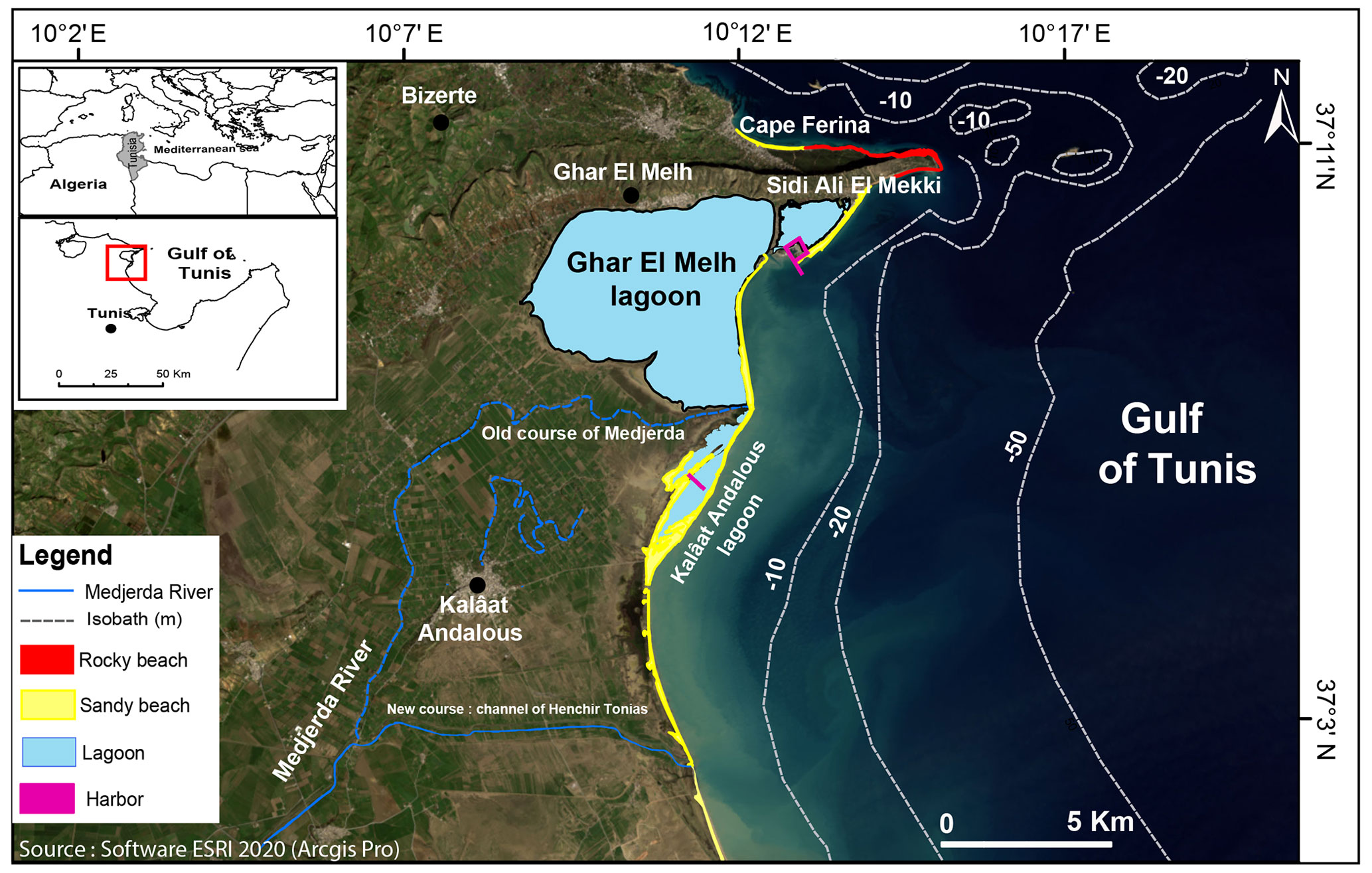
Figure 1Location and characteristics of Ghar El Melh lagoon and coast, Gulf of Tunis.
The lagoon climate setting is Mediterranean, with medium rainfall (540 mm yr−1) and an evapotranspiration rate of about 1450 mm yr−1. The seasonal variations in air temperature, with medium values ranging from 12 to 27 °C in winter and summer, respectively (INM, 2020).
3.1 Data description and sources
In this study, we used time-series remote sensing data to assess the shoreline evolution of land occupation and socioeconomic vulnerability of the Ghar El Melh coast.
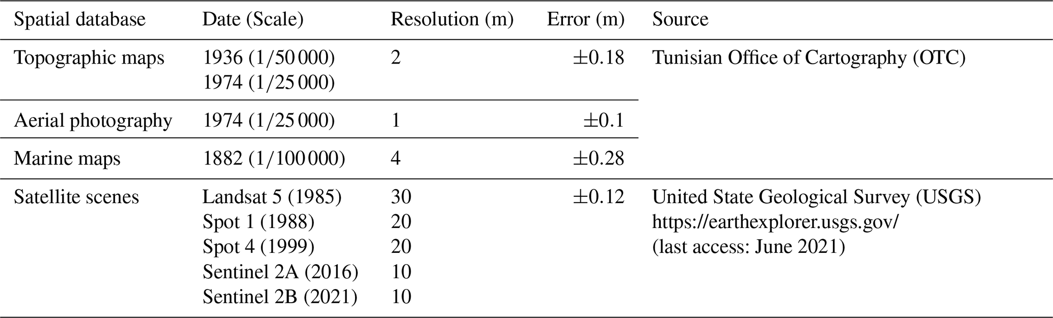
For the orbital satellite scenes, we use Landsat (1985), Spot (1988; 1999), Sentinel 2B (2016), and Sentinel 2A (2021) which have been acquired during the dry summer seasons from June to August (Table 1). These scenes are available in the archives of the U.S. Geological Survey (USGS). To perform long-term shoreline analysis (1882–2016), we also use photo-interpretation scenes such as aerial photography (1974), topographic maps (1936), and marine maps (1882) (Table 1).
Table 1Spatial scenes and thematic maps used to assess the socioeconomic vulnerability in the Ghar El Melh (Tunisia).
3.2 Land Cover/Land Use (LCLU) assessment
We used the supervised algorithmic method to generate Land Use maps using ENVI software. We applied a geometric, atmospheric, and radiometric correction to all multispectral images in Ghar El Melh between 1985 and 2021 to improve the visibility and quality of land use classifications. The region of interest (ROI) is determined from the pre-processed images and then processed to identify different terrain classes to better understand the evolution of the identified terrain classes: continental water, urban spaces, vegetations, bare soils, and sand deposits for the entire study area. For the supervised classification, we used the maximum likelihood algorithm (MacQueen, 1967).
By comparing the ROI class results generated in ENVI 5 with reference data obtained during a field campaign in the research area in April 2021, the accuracy of the Landsat 5 (1985) and Sentinel (2021) classifications (Table 1) was determined using the confusion matrix approach. Our five land cover classes, continental water, urban space, vegetation, bare soil, and sand deposit are based on statistical data on the temporal evolution of the region. For post-treatment classification algorithms, the errors of the classification methods are determined using the kappa indices and the accuracy of the two land use images of the confusion matrix (Amrouni et al., 2019b).
3.3 Socioeconomic vulnerability index
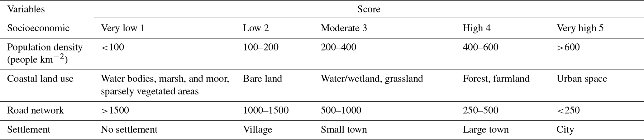
The Socioeconomic Vulnerability Index (SVI) was calculated by combining four quantitative socioeconomic variables: (1) population density, (2) land use, (3) road network, and (4) settlement, using ArcGIS software (Table 2). These variables are not exhaustive but relevant to the study area's social vulnerability. The weightings for SVI are derived using Forman and Gass (2001) Analytical Hierarchical Process (AHP) approach. The indices for the dry area of the Ghar El Melh lagoon are calculated using a mesh with each element measuring 150 m by 350 m (Hzami et al., 2021).
The AHP was created by Saaty (2000) and is used to establish the necessary weighing factors using a priority matrix. To begin, all variables are compared pairwise, and the matrix is completed by assigning a relative dominating value between 1 and 9. The priority values for socioeconomic variables were calculated, with population density at 60 % and coastal land use at 25 %.
The socioeconomic factors for the lagoon are derived from published data and international sources. ArcGIS 10.2 was used to create the input data for our coastal vulnerability analysis. All raster data is converted to vector format using the WGS82 projection for mapping purposes.
After identifying the socioeconomic parameters of the entire Ghar El Melh lagoon coast from the source data, the variables of each factor are arranged in GIS and all parameters have been assigned corresponding numerical values from 1 (very low) to 5 (very high) for each segment of the study area (Thieler and Hammar-Klose, 1999).
Table 2Ranges of the Socioeconomic Vulnerability Index, SVI (McLaughlin et al., 2002).
3.4 Shoreline dynamic
There are several methods to quantify the shoreline retreat on sandy coasts. The first approach was developed by Kriebel (1982). This model estimates the potential shoreline retreat rate in relation to the return period of a high-water level (FEMA, 2003). The second method is based on the development and using numerical models. The XBeach and Telemac models are the most used (Roelvink et al., 2009; Pender et al., 2015). However, these models did not use high-resolution spatial data (satellite scenes, aerial photography, etc.).
Finally, the third model is the Digital Shoreline Analysis System (DSAS). It consists in quantifying the impact of storms by measuring, using transects perpendicular to the shoreline, the distance between the pre-storm and post-storm shoreline which have been previously digitized in a database of aerial photographs. This method relies on a high-resolution database of photogrammetric and thematic scenes to assess short, medium, and long-term historical shoreline trends (Thieler et al., 2009; Amrouni et al., 2019b). The high use of the DSAS tool is due to its easy integration with Esri ArcGIS software. This combination helps calculate the distance between each transect and the baseline and provides a simple interface for statistical analysis of shoreline changes (Mishra et al., 2020).
In the present study, we use the DSAS approach implemented using datasets from Spot (1988 and 1999) and Sentinel 2B (2016), aerial photography (1974), topographic maps (1936), and marine maps to perform long-term shoreline monitoring (1882) (Table 1). Orthogonal transects of 1000 m are used to quantify the shoreline changes which have occurred along the sandy barrier of the Ghar El Melh. The statistics of the computed rate-of-change enable us to create time series in GIS that depict the temporal evolution of the shoreline's geometries and positions over the last century. We use two statistical outputs from the DSAS model in our analysis: (1) the Net Shoreline Movement (NSM), which shows the total reported separation between the oldest (1882) and most recent (2016) shoreline positions; and (2) the End Point Rate (EPR), which shows the annual rate of shoreline retreat. Finally, using Morgan et al. (1997) and Van der Wal and Pye's (2003) techniques, the inaccuracy in estimating shoreline change rates is measured.
4.1 Shoreline evolution of Ghar El Melh coastline
The evolution of the coastline of Ghar El Melh during the 20th century is mainly influenced by the action of the sea, the river discharge of the Medjerda River, and the maritime anthropogenic developments along the coastal ridge of the Sabkha Sidi Ali El Mekki (Amrouni et al., 2020).
The subdivision of the mean time scale was carried out according to the dynamics of the littoral system at the multi-decadal scale. Two periods can be individualized:
-
Period 1882–1974: This period concerns the natural dynamics of the coastline.
-
Period 1974–2016: This is the period when human activities started with the deviation of the Medjerda River in 1973 and the building of the new port of Ghar El Melh in 1974.
- a.
Natural evolution. Ghar El Melh beach is bordered in the north by the fishing port and in the south by the old mouth of the Medjerda River (Fig. 2). From 1882 to 1974, the sandy barrier of Ghar El Melh underwent a natural progradation with accretion rates EPR between and 3.85±0.16 m yr−1.
- b.
Anthropogenic evolution. After the construction of the fishing harbor in 1974, the northern part of the sandy barrier experienced intense erosion between 1974 and 2016, with an average EPR rate of m yr−1. The highest erosion rate observed in this region is an NSM of m yr−1, between 1999 and 2016 (Fig. 2).
- a.
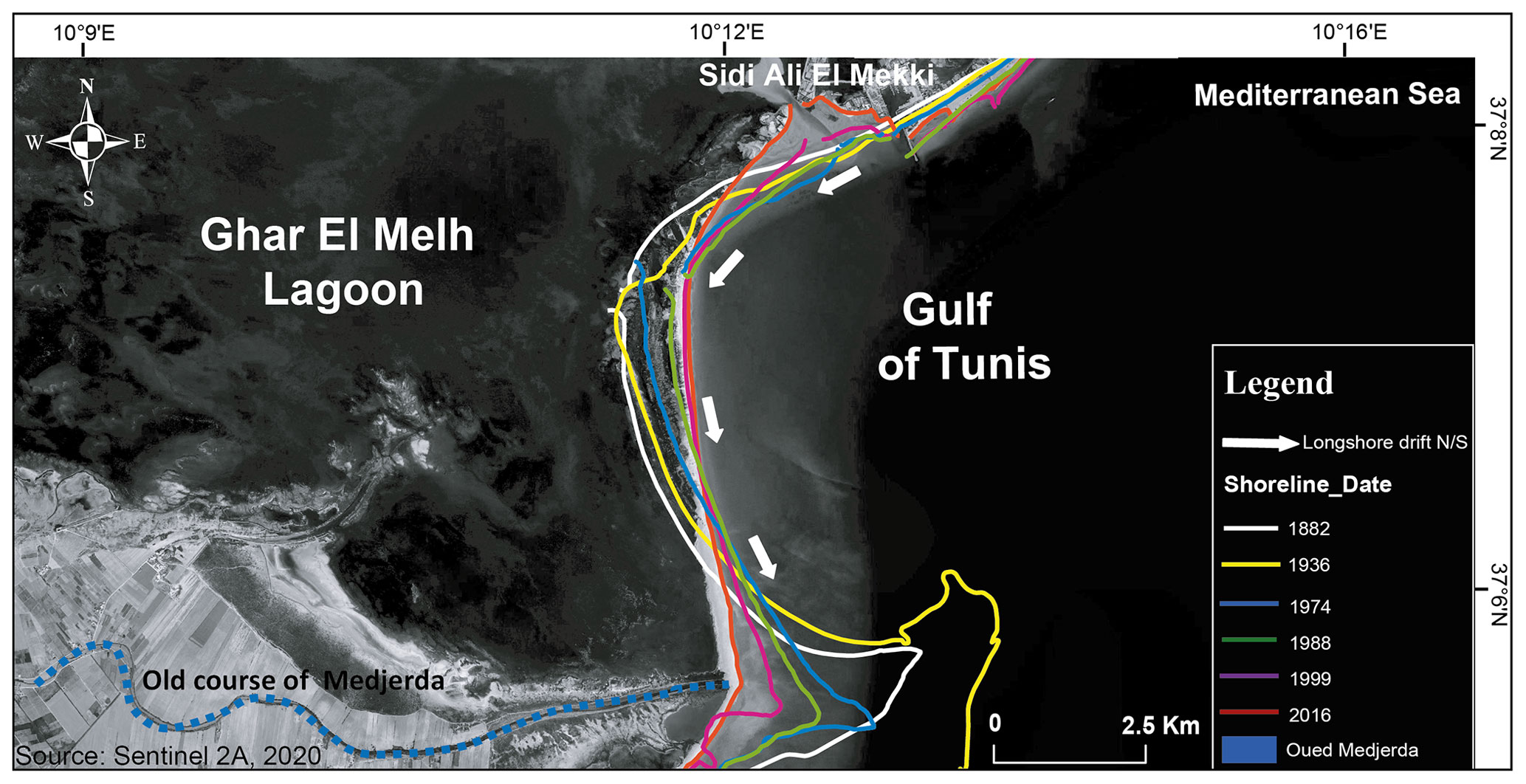
Figure 2The shoreline movement trend along the beaches of the Ghar El Melh coastline from 1882 to 2016.
This trend has resulted in the erosion of much of the cultivated land along the sandy barrier of Ghar El Melh Lagoon, as well as the destruction of several urban structures along this beach. A similar study using Landsat scenes along this zone shows that the maximum shoreline retreat is m yr−1 (Saïdi et al., 2014). This severe erosion is largely due to the change in the morphology of the alluvial coastal plain and the reduction in the sediment supply of the Medjerda River (Paskoff, 1994; Benmoussa et al., 2019). After the great flood of 1973, 18 km south of the Ghar El Melh lagoon was naturally drained (Fig. 1). According to Amrouni al. (2023), the low sedimentation in the highly vulnerable coast, will lead to a near coastal submersion of the sandy barrier of Ghar El Melh lagoon.
The sediment transport vectors observed at the lagoon coast show a dominant N/S direction (Beji, 2019). This longitudinal coastal transit causes the reduction of the sediment budget of the coast in coarse load and the erosion of the shoreline (Amrouni et al., 2014, 2019a).
4.2 The Land Use/Land Cover changes
The supervised classification of both Landsat (1985) and Sentinel 2A (2021) images into 6 classes is based on the “maximum likelihood” method. This method provides the resolution closest to nature, as described in Fig. 3, based on the natural colors of the different classes. Based on the distribution of these colors, we notice a decrease in vegetation cover and an increase in urban space between 1985 and 2021. The statistical class analysis for the supervised classification of the two Landsat (1985) and Sentinel 2A (2021) images is shown in Fig. 3. According to the diagram of the areas of the land occupation units of Ghar El Melh in 1985 and 2021 (Fig. 4), we note:
-
Reduction of the vegetation class by 9 %;
-
Increase in urban space by 8 %;
-
Increase in the surfaces of bare land by 5 %;
-
Reduction of agricultural activities by 5 %.
The identification of land cover changes between 1985 and 2020 shows that the natural space is significantly reduced by the rapid expansion of cities in the surrounding area. Hydraulic management of the river network reduces sediment and water flow into the depression, resulting in a reduction in the water balance and an increase in the evaporation rate into the low-lying watershed, which is here covered by the Sabkha environment. The anthropogenic factors are also enhanced by the climatic aridification of the North African regions.
Evaluation of the supervised classification methods for the two sets of satellite scenes using the confusion matrices shows that the kappa indices are 0.90 for Landsat 5 (1985) and 0.93 for Sentinel 2A (2021). The accuracy of this classification is ∼ 95 %, indicating maps with high reliability.
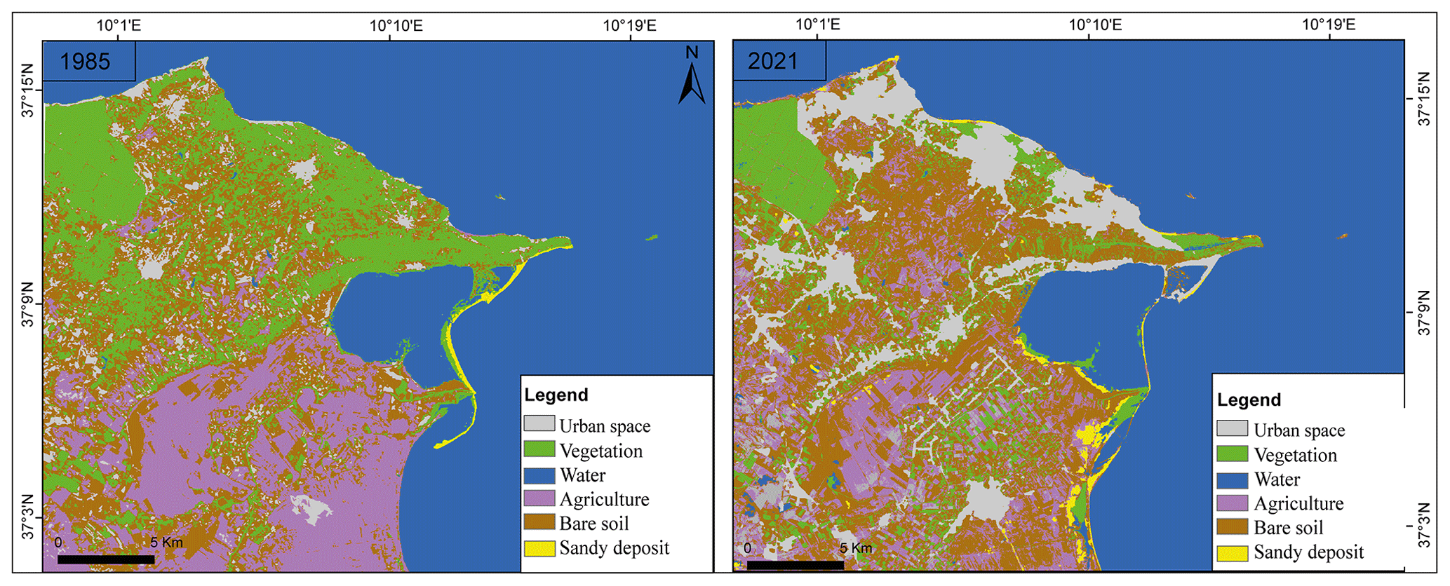
Figure 3Detection of changes in LULC from the supervised classification between 1985 and 2021 from Landsat 5 (1985) and Sentinel 2A (2021) scenes.
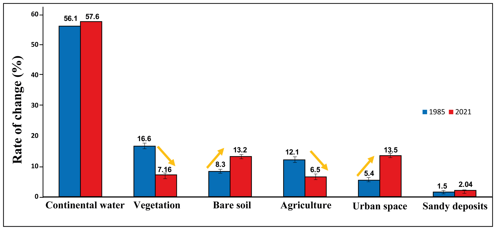
Figure 4The statistical temporal evolution of LULC classes in the lagoon between 1985 and 2021.
4.3 Socioeconomic vulnerability
Mapping of SVI values reveals that 55 % of the lagoon coastline experienced a very high vulnerability (scores 4 and 5), 30 % is at high vulnerability (score 3), and 15 % is classified as moderately vulnerable (scores 1 and 2) (Fig. 5). SVI levels are significantly higher in areas with rapid urbanization. The most vulnerable areas are in the low-lying deltaic plain of the Medjerda River. The extent of these coastal vulnerabilities results in significant degradation of coastal aquifers and consequent deterioration of crop productivity, threatening food security and leading to migration out-flows (Hzami et al., 2021).
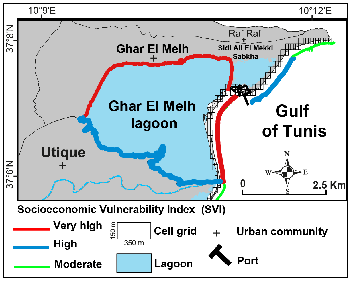
Figure 5Vulnerability scale of socioeconomic variables SVI for the Ghar El Melh Lagoon, Gulf of Tunis.
Our study suggests that the high socioeconomic coastal vulnerability area observed in the Ghar El Melh lagoon is primarily due to the rapid and extensive urbanization occurring over the last few decades. SVI values reveal that 85 % of the Ghar El Melh lagoon and its associated coast are characterized by high to very high vulnerability. Additionally, the temporal analysis of the aerial and orbital photogrammetric scenes suggests that ∼ 70 % of the Ghar El Melh coast's sandy beaches are currently eroding at an average EPR rate of −2 m yr−1. Anthropogenic factors, such as population density and land occupation, are found to be the main drivers of the observed shoreline retreat and the associated socioeconomic vulnerability in Ghar El Melh. The above results from decreased vegetation cover, water budget, sand deposit, and the increase in salt flats and urban spaces. These anthropogenic factors further aggravate the impacts of hydroclimatic extremes widely observed in the region over the last decade. Restoring a substantial part of the vegetation coverage and stabilizing the sandy barriers with the natural-based solution can reduce the vulnerability in the mid and long terms, but comprehensive urban planning that considers the recent hydroclimatic changes in this area need to be urgently implemented to mitigate the short-term impacts.
The data processing was done by ArcGIS Software. The type of my license is “GIS Professional Advanced” provided by the university of Soutern California (USC) https://uscssi.maps.arcgis.com/home/index.html (last access: September 2023) subscription code for my account: Abderraoufhzami_USCSSI.
The USGS Earth Explorer gives a quick way to download free satellite imagery for our paper (https://www.usgs.gov/centers/eros/science/usgs-eros-archive-sentinel-2, USGS, 2018). All the data used in this analysis are openly available as listed in Table 1.
Conceptualization, AH; methodology, AH, OA and EH; writing – original draft preparation: AH, data acquisition, and analysis: OA; writing – review and editing, AH, OA, EH and GM; supervision, OA and EH; project administration, HM; funding acquisition, GM and EH. The published version of the manuscript has been approved by all authors.
The contact author has declared that none of the authors has any competing interests.
Publisher's note: Copernicus Publications remains neutral with regard to jurisdictional claims in published maps and institutional affiliations.
This article is part of the special issue “IAHS2022 – Hydrological sciences in the Anthropocene: Past and future of open, inclusive, innovative, and society-interfacing approaches”. It is a result of the XIth Scientific Assembly of the International Association of Hydrological Sciences (IAHS 2022), Montpellier, France, 29 May–3 June 2022.
The authors would like to thank all researchers who contributed to the implementation of the scientific tasks of this work. The authors also thank the Copernicus editorial team for the review that helped improve this paper.
This research has been supported by the National Institute of Marine Sciences and Technologies in Tunisia, University of Carthage. This work was developed under the tasks of the PHC-UTIQUE-ECOBAM (grant no. 21G1002) project and the Arid and Water Research Center at the University of Southern California. Postdoc Abderraouf Hzami received funding under support from the Zumberge Research and Innovation Fund of the University of Southern California.
This paper was edited by Christophe Cudennec and reviewed by Ernest Amoussou and one anonymous referee.
Abulhawa, T. and Cummings, T.: Rapid cultural inventories of wetlands in Arab states including Ramsar Sites and World Heritage Properties: Building greater understanding of cultural values and practices as a contribution to conservation success, Arab Regional Centre for World Heritage and Ramsar Convention Secretariat, https://www.ramsar.org/rapid-cultural-inventories-wetlands-arab-states (last access: September 2023), 2017.
Amrouni, O., Hermassi, T., Abdeljaouad, S., and Messaoudi, S.: Contribution of Grain–size Trend to Sediment of a Microtidal Beach. Case of the Gulf of Tunis Bay (Cape Ferina–Cape Gammarth, Tunisia), Research Journal of Environmental Sciences, 8, 161–177, https://doi.org/10.1007/978-3-319-70548-4_495, 2014.
Amrouni, O., Sánchez, A., Khélifi, N., Ben Moussa, T., Chiarella, D., Mahé, G., Abdeljaouad, S., and McLaren, P.: Sensitivity assessment of the deltaic coast of Medjerda based on fine grained sediment dynamics, Gulf of Tunis, Western Mediterranean, J. Coast. Conserv., 23, 571–587, https://doi.org/10.1007/s11852-019-00687-x, 2019a.
Amrouni, O., Hzami, A., and Heggy, E.: Photogrammetric assessment of shoreline retreat in North Africa: Anthropogenic and natural drivers, ISPRS J. Photogram. Remote Sens. 157C, 73–92, 2019b.
Amrouni, O., Beji, Y., Heggy, E., and Sánchez, A.: Coastal Sedimentary dynamic of wetland ecosystem of semi-arid areas in north Africa, in: 3rd Conference of the Arabian Journal of Geosciences, Sousse, Tunisia, 2–5 November 2020, http://www.cajg.org/index.php (last access: September 2023), 2020.
Amrouni, O., Ibrahim, H.S, Hzami, A., Missaoui, H., Mahe, G., and Heggy, E.: Eroding coastal sandy barriers under changing aeolian flux in the Gulf of Tunis, Bull. Inst. Natl. Sci. Technol. Mer., 48, 37–48, https://www.instm-bulletin.tn/index.php/bulletin/article/view/298, last access: September 2023.
Beji, Y.: Dynamique sédimentaire du littoral de Ghar El Melah: Evolution naturelle et impacts anthropiques, Université de Tunis, Faculté des sciences de Tunis, 109 pp., http://hdl.handle.net/1834/41840 (last access: September 2023), 2019.
Benmoussa, B. T., Amrouni, O., Hzami, A., Dezileau, L., Mahe, G., Condomines, M., and Saadi, A.: Progradation and retrogradation of the Medjerda delta during the 20th century (Tunisia, western Mediterranean). Comptes Rendus Geosciences, 351, 340–350, https://doi.org/10.1016/J.Crte.2018.10.004, 2019.
Cooper, J. A. G., Green, A. N., and Loureiro, C.: Geological constraints on mesoscale coastal barrier behaviour, Global Planet. Change, 168, 15–34, https://doi.org/10.1016/j.gloplacha.2018.06.006, 2018.
Delile, H., Abichou, A., Gadhoum, A., Goiran, J. P., Pleuger, E., Monchambert, J. Y., Wilson, A., Fentress, E., Quinn, J., Ben Jerbania, I., and Ghozzi, F.: The geoarchaeology of Utica, Tunisia: the paleogeography of the Mejerda Delta and hypotheses concerning the location of the ancient harbor, Geoarchaeology, 30, 291–306, https://doi.org/10.1002/gea.21514, 2015.
Federal Emergency Management Agency (FEMA): Guidelines and Specifications for Flood Hazard Mapping Partners, Appendix D: Guidance for Coastal Flooding Analyses and Mapping, Prepared under FEMA's Flood Hazard Mapping Program, https://www.fema.gov/sites/default/files/nepa/ (last access: September 2023), 2003.
Forman, E. and Gass, S.: The Analytic Hierarchy Process – An Exposition, Oper. Res., 49, 469–486, 2001.
Fouad, S. S., Heggy, E., and Weilacher.: Waterways transformation in the vulnerable port city of Alexandria, Cities, 141, 104426, https://doi.org/10.1016/j.cities.2023.104426, 2023.
Gaaloul, N., Amrouni, O., Heggy, E., Douss, N., Hzami, A., Khélifi, N., Bejaoui, B., and Sánchez, A.: Impacts of water stress on lagoonal ecosystem degradation in semi-arid coastal areas, Mar. Pollut. Bull., 179, 113445, https://doi.org/10.1016/j.marpolbul.2022.113445, 2022.
Hzami, A., Amrouni, O., Romanescu, G., Constantin Stoleriu, C., Mihu-Pintilie, A., and Saâdi, A.: Satellite images survey for the identification of the coastal sedimentary system changes and associated vulnerability along the western bay of the Gulf of Tunis (northern Africa), Proc. IAHS, 377, 83–89, https://doi.org/10.5194/piahs-377-83-2018, 2018.
Hzami, A., Heggy, E., Amrouni, O., Mahé, G., Maanan, M., and Abdeljaouad, S.: Alarming coastal vulnerability of the deltaic and sandy beaches of North Africa, Sci. Rep., 11, 2320, https://doi.org/10.1038/s41598-020-77926-x, 2021.
Institut National de la Météorologie (INM): Données numériques (brutes), https://www.meteo.tn/fr/donnees-climatiques, last access: June 2020.
Kotti, F., Dezileau, L., Mahé, G., Habaieb, H., Bentkaya, M., Dieulin, C., and Amrouni, O.: Etude de l'impact des barrages sur la réduction des transports sédimentaires jusqu'à la mer par approche paléohydrologique dans la basse vallée de la Medjerda, Proc. IAHS, 377, 67–76, https://doi.org/10.5194/piahs-377-67-2018, 2018.
Kriebel, D. L.: Beach and Dune Response to Hurricanes, unpublished M.S. Thesis, Department of Civil Engineering, University of Delaware, Newark, DE, 1982.
Lionello, P. and Scarascia, L.: The relation between climate change in the Mediterranean region and global warming, Reg. Environ. Chang., 18, 1481–1493, 2018.
Louati, M., Saïdi, H., and Zargouni, F.: Shoreline change assessment using remote sensing and GIS techniques: a case study of the Medjerda delta coast, Tunisia, Arab. J. Geosci., 8, 4239–4255, https://doi.org/10.1007/s12517-014-1472-1, 2014.
MacQueen, J. B.: Some Methods for classification and Analysis of Multivariate Observations, in: Proceedings of 5th Berkeley Symposium on Mathematical Statistics and Probability, Berkeley, University of California Press, 1, 281–297, http://projecteuclid.org/euclid.bsmsp/1200512992 (last access: September 2023), 1967.
Mahapatra, M., Ramakrishnan, R., and Rajawat, A.: Coastal vulnerability assessment using analytical hierarchical process for South Gujarat coast, India, Nat. Hazards, 76, 139–159, 2015.
McLaughlin, S., McKenna, J., and Cooper J. A. G.: Socio-economic data in coastal vulnerability indices: constraints and opportunities, J. Coast. Res., 36, 487–497, 2002.
Mishra, M., Sudarsan, D., Kar, D., Naik, A. K., DAS, P. P., Santos, C. A., and da Silva, R. M.: The development and Research trend of using DSAS tool for shoreline change analysis: A scientometric analysis, Urban Environ. Eng., 14, 69–77, https://doi.org/10.4090/juee.2020.v14n1.069077, 2020.
Morgan, A., Larson, R., and Gorman, L.: Monitoring the coastal environment: part III: geophysical research methods, J. Coastal Res., 13, 1064–1085, 1997.
Moussa, M., Baccar, L., and Ben Khemis, R.: La lagune de Ghar El Melh: Diagnostic écologique et perspectives d'aménagement hydraulique, Revue des Sciences de l'Eau, 18, 13–26, 2005.
Oueslati, A., El Aroui, O., and Sahtout, N.: Sur la grande vulnérabilité du lido du complexe lagunaire de Ghar El Melh et de ses terres humides (Tunisie septentrionale). Érosion, risque de maritimisation et menaces sur le terroir original Ramli, Méditerranée, 125, 65–73, 2015.
Paskoff, R.: Les plages de la Tunisie, Editec, Caen, 198 pp., https://journals.flvc.org/jcr/article/view/77401 (last access: September 2023), 1985.
Paskoff, R.: Les littoraux. Impact des aménagements sur leur évolution, Paris, Masson, https://www.persee.fr/doc/rga_0035-1121_1985_num_73_3_2607_t1_0345_0000_1 (last access: September 2023), 1994.
Pausas, J. G. and Millán, M. M.: Greening and Browning in a Climate Change Hotspot: The Mediterranean Basin, Bioscience, 69, 143–151, 2019.
Pender, D., Callaghan, D. P., and Karunarathna, H.: An evaluation of methods available for quantifying extreme beach erosion, Journal of Ocean Engineering and Marine Energy, 1, 31–43, https://doi.org/10.1007/s40722-014-0003-1, 2015.
Pérez-Ruzafa, A., Marcos, C., and Pérez-Ruzafa, I. M.: Mediterranean coastal lagoons in an ecosystem and aquatic resources management context, Phys. Chem. Earth, 36, 160–166, https://doi.org/10.1016/j.pce.2010.04.013, 2010.
Roelvink, D., Reniers, A., van Dongeren, A., van Thiel de Vries, J., McCall, R., and Lescinski J.: Modelling storm impacts on beaches, dunes and barrier islands, Coast. Eng., 56, 1133–1152, https://doi.org/10.1016/j.coastaleng.2009.08.006, 2009.
Saaty, T. L.: Fundamentals of decision-making and priority theory, Pittsburgh, RWS Publications, ISBN 0962031763, https://books.google.tn/books?id=wct10TlbbIUC&hl=fr&source=gbs_book_other_versions (last access: September 2023), 2000.
Saïdi, H., Souissi, R., Louati, M., and Zargouni, F.: Morphologic changes and sedimentary budgets along a Mediterranean coastline with a sand spit: case of the littoral fringe Sidi Ali El Mekki-Gammarth (NE Tunisia), Rend. Fis. Acc. Lincei, 25, 393–401, https://doi.org/10.1007/s12210-014-0314-0, 2014.
Salhi, A., El Hasnaoui, Y., Pérez Cutillas, P., and Heggy E.: Soil erosion and hydroclimatic hazards in major African port cities: the case study of Tangier, Sci. Rep., 13, 13158, https://doi.org/10.1038/s41598-023-40135-3, 2023.
Samàali, H.: Etude de l'évolution de l'occupation et de l'utilisation du sol dans le delta de Medjerda par télédétection et systèmes d'informations géographiques, PhD thesis, University of Tunis, Fac. Sci. Hum. Soc. Geography., 376 pp., https://hal.archives-ouvertes.fr/tel-00612952/ (last access: September 2023), 2011.
Thieler, E. R. and Hammar–Klose, E. S.: National assessment of coastal vulnerability to future sea–level rise: preliminary results for the U.S. Atlantic coast, U.S. Geological Survey, Open-File Report, 99-593, https://doi.org/10.3133/ofr99593, 1999.
Thieler, E. R., Himmelstoss, E. A., Zichichi, J. L., and Ergul, A.: The Digital Shoreline Analysis System (DSAS) Version 4.0-An ArcGIS Extension for Calculating Shoreline Change, Open-File Report, US Geological Survey Report, 2008-1278, https://doi.org/10.3133/ofr20081278, 2009.
Thieler, E. R. and Young, R. S.: Quantitative Evaluation of Coastal Geomorphological Changes in South Carolina after Hurricane Hugo, J. Coast. Res., 8, 187–200, 1991.
USGS: USGS EROS Archive – Sentinel-2, USGS [data set], https://www.usgs.gov/centers/eros/science/usgs-eros-archive-sentinel-2 (last access: September 2023), 2018.
Van der Wal, D. and Pye, K.: The use of historical bathymetric charts in a GIS to assess morphological change in estuaries, Geogr. J., 169, 21–31, 2003.