the Creative Commons Attribution 4.0 License.
the Creative Commons Attribution 4.0 License.
 | 04 Jul 2024
Flood risk management in planning and construction of city: the Guangzhou experience
Minyi Kuang
Yanyan Zheng
Xingdong Deng
Yukui Yang
Jingchen Wang
Xintian Sui
Yuan Peng
Recently, urban flood disasters caused by rainstorm has happened more and more frequently. Chinese government has proposed that the urban flood disasters problem should be solved by integrated and systematic approach. The analysis of the historical rainstorm flood events of Guangzhou in the past 10 years showed that, the urban rainstorm flood has happened more frequently in lowland, hardening underlying surface and drainage system jacked by high water level. Guangzhou has innovatively delimited high-risk regions by watershed units, using Remote Sensing (RS) data and GIS data, which become the basis of flood risk management. The vertical planning, the storage capacity and river managing boundary have become three important conditions, which should be taken into consideration in the construction projects and serve as the basis for the whole life cycle. As a pioneer, Guangzhou has provided experience for metropolis to reduce flood risk in the construction stage. This paper analyzes the changes and causes of the overall flood safety situation in Guangzhou, and introduces the practice and exploration in Guangzhou from the aspects of promoting the accurate identification of flood risk areas, guiding the spatial control of flood control and drainage safety with planning, establishing the planning transmission mechanism, implementing the flood risk assessment system, and ensuring the transformation of resilient city goals.
- Article
(13527 KB) - Full-text XML
- BibTeX
- EndNote


On the study of urban waterlogging, the industry and academia have accumulated many research results. In the 1980s, mainly studying urban waterlogging caused by rainstorms, focusing on urban flooding caused by river basin floods. In the 1990s, the main research was on the influence of human factors such as urban construction on urban waterlogging. Since 2000, the drainage model began to simulate, summarize the causes of urban waterlogging or conduct in-depth research on a cause, and study foreign advanced concepts and technical means (Xia et al., 2018).
At present, the causes of waterlogging are all single factor analysis. There are many studies on single factors such as drainage system, underlying surface, depression, and temporal and spatial characteristics of rainfall, but there is still a lack of relevant research content on the coupling of these factors to identify potential waterlogging prone areas (Wang and Wang, 2018). Therefore, it is of great significance in planning, construction and management to study the causes of waterlogging and identify potential flood-prone areas by integrating natural rainfall factors and ground hazard factors.
In April 2021, Chinese General Office of the State Council issued the implementation opinions on enhancing urban rainstorm flood. “According to the requirements of building sponge cities and resilient cities, measures should be taken according to local conditions and cities to improve urban flood control and drainage capacity, and urban rainstorm flood problems should be solved in a coordinated and systematic way.” (Suggestions on strengthening urban waterlogging control, 2021) has been put forward. Guangzhou is located at the Pearl River Estuary, with the geographical characteristics of coastal area. The north of Guangzhou is vulnerable to torrential flood, the middle is prone to rainstorm flood and tropical cyclones and storm surges in the south. In recent years, due to the influence of extreme weather, extraordinary storm happened in Guangzhou frequently (Ai and Wu, 2018; Wang et al., 2020). Rapid urban development leads to the expansion of hardened underlying surface and the increase of rainstorm flood risk (Guo and Deng, 2011; Cheng and Li, 2015). Guangzhou has tried to solve the problem of rainstorm flood management in the source and system (Cheng, 2022; Zhan et al., 2021). This paper analyses the changes of flood risk in Guangzhou, and introduces the practice and exploration of Guangzhou in promoting the accurate identification of flood risk areas, which can guide the spatial flood control in the stage of planning, and implementing the flood risk assessment system.
Combination of drainage and storage has been basically formed in Guangzhou. In recent years, Guangzhou improved disaster emergency management by the optimizing channel management, building water conservancy facilities and improving the construction standard of drainage system.
However, affected by extreme weather changes and urban development, urban flood control has faced with new challenges (Huang et al., 2021). By 2020, there have been 639 rainstorm flood points in the whole city. Compared with 2010, the situation of rainstorm flood has increased outside the central area (Fig. 1).
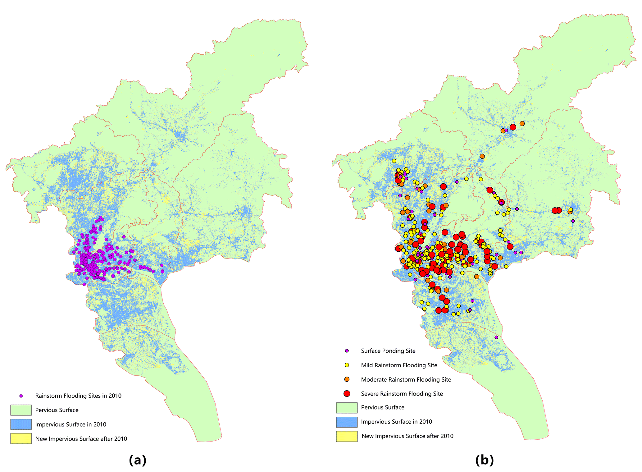
Figure 1Distribution of rainstorm flooding sites in Guangzhou. (a) Analysis in 2010. (b) Analysis in 2020.
2.1 Meteorology and hydrology
According to the statistics of rainfall data from 1955 to 2010, the frequency of rainstorms in the central area of Guangzhou was 8.7 d, the average contribution rate of rainstorms was 32.8 %, and the average intensity of rainstorms was 79.5 mm d−1. In recent years, the heavy rainfall showed the characteristics of greater intensity, more frequent and wider range. The highest tide level of the Pearl River in Guangzhou shows an upward trend. Since 2005, there have been four high tide levels exceeding the design standard (200-year return period) of the embankment.
2.2 Underlying surface
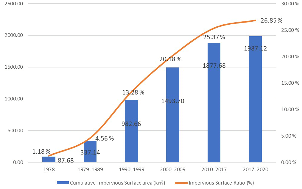
With the intensification of urban development, the total built-up area of the city increased from 952 km2 in 2010 to 1324 km2 in 2019, with a net increase of 372 km2. In recent ten years, the ground impervious rate has increased from 20.18 % to 26.85 % (Fig. 2). The expansion of impervious surface causes the increase of runoff, which is easy to cause rainstorm flood.
2.3 Stormwater storage
The water surface rate of the whole city is 10.15 %. However, the water surface rate is insufficient in the northern regions, and is large in the southern river network regions. During the construction of city, rainwater storage space and drainage channels are crowded, so that the drainage and flood prevention ability of the river basin is sharply reduced. At the same time, due to the large increase of impervious area, the peak flow and total flow of rainstorm flood increase, which causes the drainage system greatly impacted.
2.4 Vertical design
According to the analysis of the digital elevation model, the ground elevation of most areas in Panyu and Nansha in the south of Guangzhou is below 8.00 m (Fig. 3), while the highest tide level of the Pearl River in the past two years has exceeded 8.00 m, posing a high risk of flood.
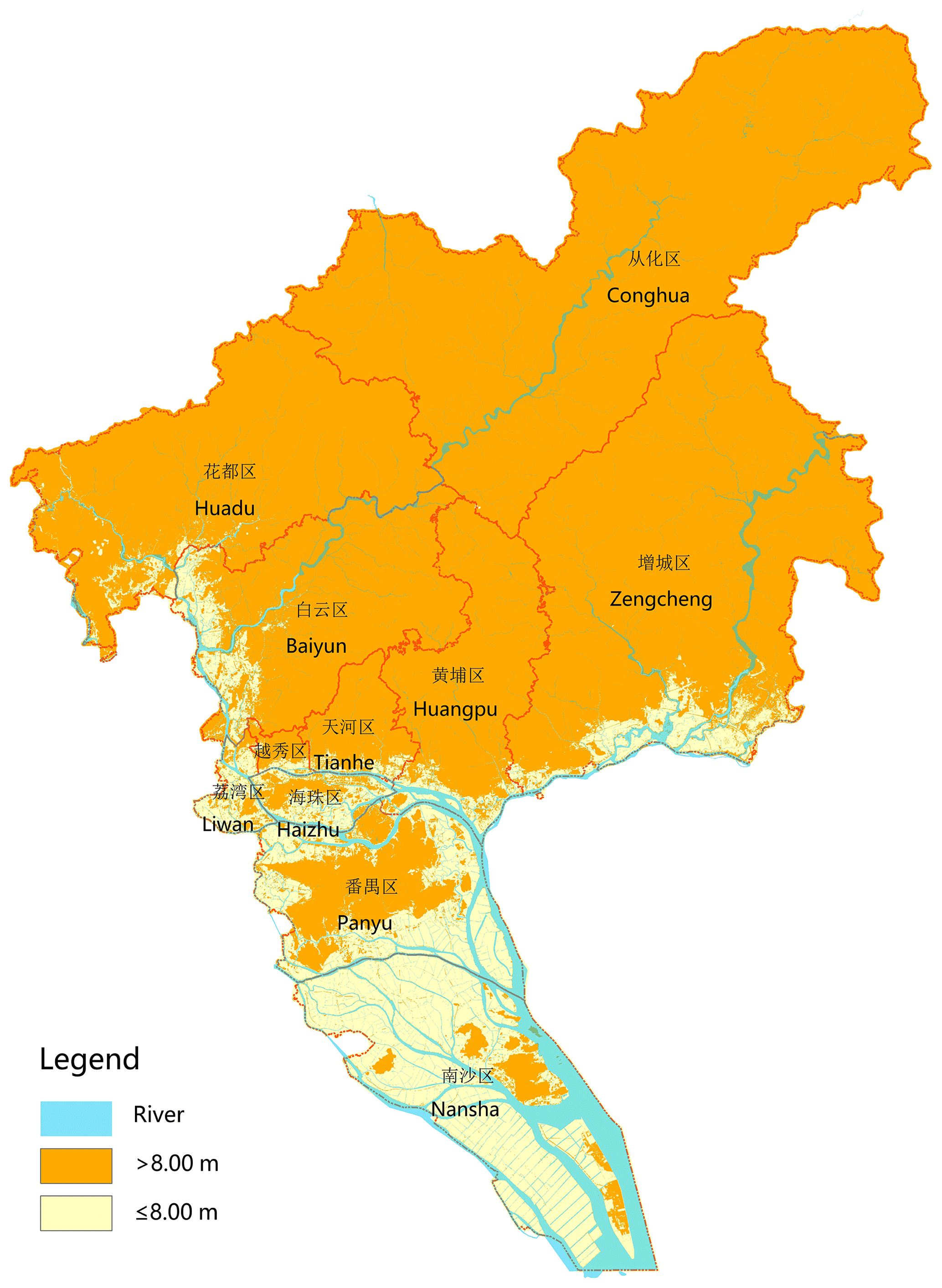
Figure 3Digital elevation model analysis of Guangzhou.
There are three vulnerabilities in the systematic control of ground elevation in Guangzhou. Firstly, the elevation connection between the old and new construction areas is not reasonable. The terrain of the old residential areas and villages is often lower than the surrounding municipal roads and new development plots, which are prone to rainstorm flood disasters during heavy rains. Secondly, in the process of urban planning and construction, the ground elevation is not fully connected with the drainage system, resulting in local depressions, leading to systemic flood risk. Thirdly, improper vertical elevation control of major construction projects such as bridges, tunnels and culverts, and rail transit forms local depressions, which become the weakness of regional drainage system. According to the analysis and statistics of causes of flood points in 2020, 20 % of these points are caused by insufficient connection between ground elevation and drainage system.
In the face of uncertain rainfall exceeding the standard, the flood risk management in Guangzhou has shifted from focusing on engineering defence to urban planning control. The following are the main practices and exploration of flood risk management in Guangzhou in recent years.
In recent years, Guangzhou has been exploring the experience of rainstorm flood management in megacities, trying to solve the problem of flood risk management with remote sensing means. Through the innovative use of remote sensing technology and LIDAR digital elevation model and other geographic information technology, we identified the impervious ground and low-lying land, and reveal the relationship between impervious ground, depression and urban rainstorm flood.
Firstly, we extracted impervious ground from 105 catchments area in the city. Using remote sensing technology, we found that, the impervious surface rate of the central urban area is 80 %–99 %, and the impervious ground area has been basically stable (Fig. 4). In other urban expansion areas, the impervious surface rate is 60 %–80 %, and the impervious surface rate increases by more than 20 % in recent years, indicating a high risk of rainstorm flood. The catchment area, which has a low average impervious surface rate in the upstream, but has a high rate in the downstream, has a high risk of flooding.
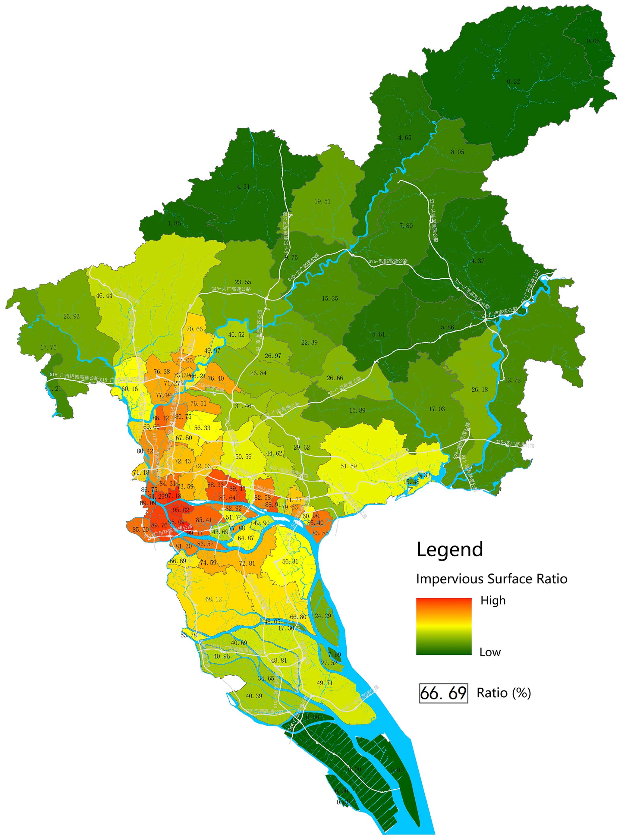
Figure 4Analysis of ground im-permeability in 105 catchments of Guangzhou.
Secondly, by combining the DEM (2 m accuracy) of the city's LIDAR high-resolution digital elevation model with the ArcGIS water conservancy analysis model, the maximum slope method was used to accurately identify the low-lying land in the city (Fig. 5). We found that, the proportion of non-depression land in Guangzhou is 84.85 %, and the proportion of depression land is 15.15 %. Among them, the low-lying depth less than 0.5 m accounted for 6.53 % of the city's area, the low-lying depth of 0.5–1.0 m accounted for 3.67 %, the low-lying depth of 1.0–1.5 m accounted for 1.73 %, the low-lying depth of 1.5–2.0 m accounted for 0.98 %, the low-lying depth greater than 2.0 m accounted for 2.24 %.
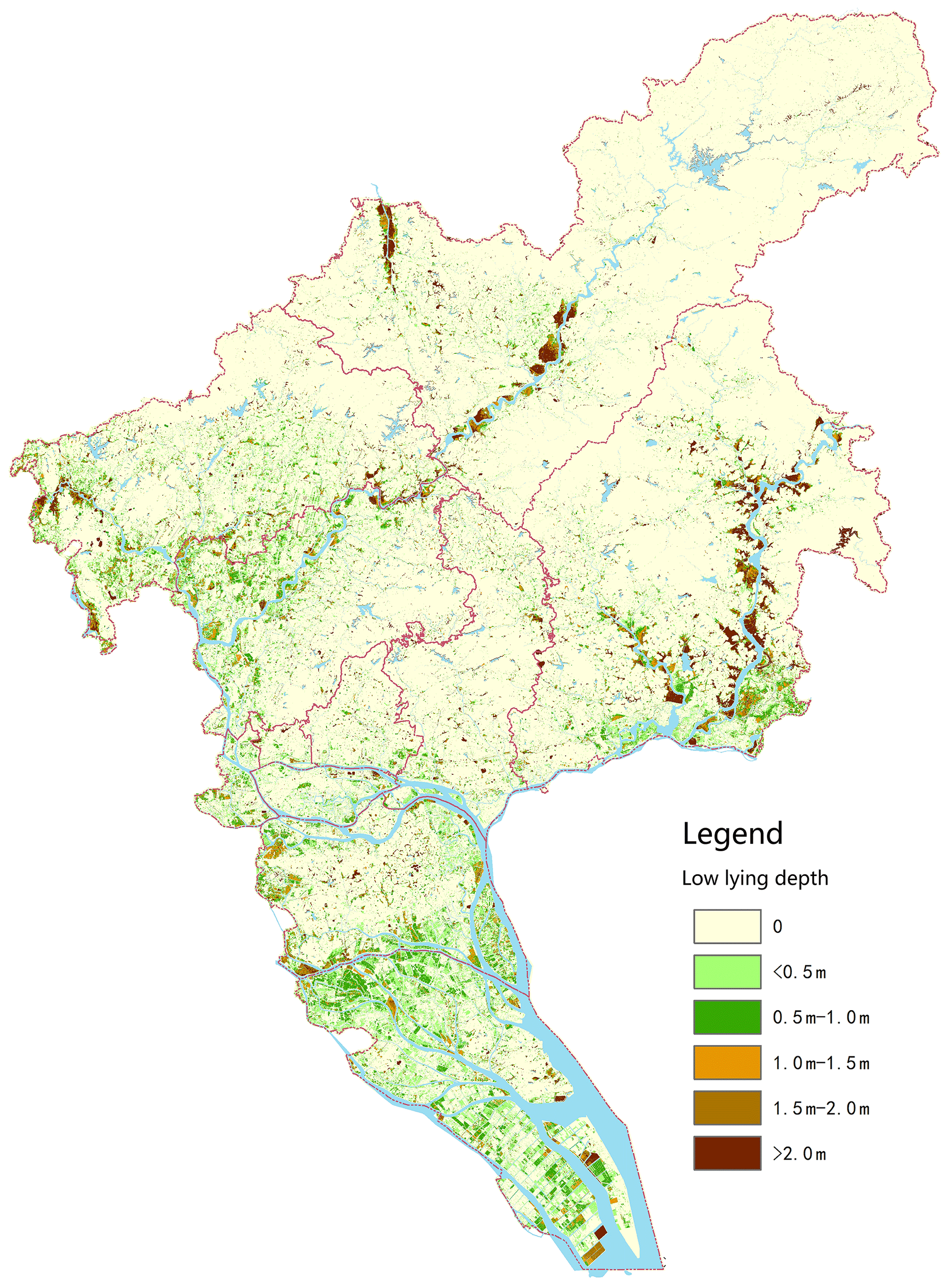
Figure 5Distribution of low-lying land in Guangzhou.
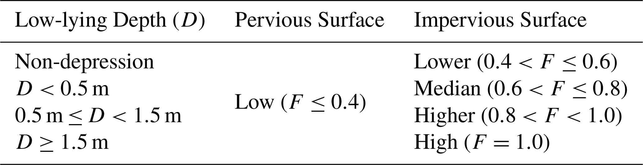
Thirdly, dividing impermeable ground into 2 levels and low-lying land into 4 levels, the two main impact factors were superimposed and standardized, and then we calculated the environmental flooding risk index (F) of points and divided five degrees of rainstorm flooding risk (Table 1).
Fourthly, The rainstorm flooding risk degrees was divided according to the two main influencing factors of impervious ground and depth of low-lying land, and the contiguous areas with high, higher and median rainstorm flooding risk degree were preliminarily designated as high-risk areas. By comparing the relationship between the water surface line of the river surge and the topography, and considering the influencing factors of the flood tide level of the Pearl River breaking 8.00 m, the boundary of the preliminarily drawn waterlogging prone risk areas was revised, and the modified 62 high-rainstorm-flood-risk areas of the city were finally determined (Fig. 6).
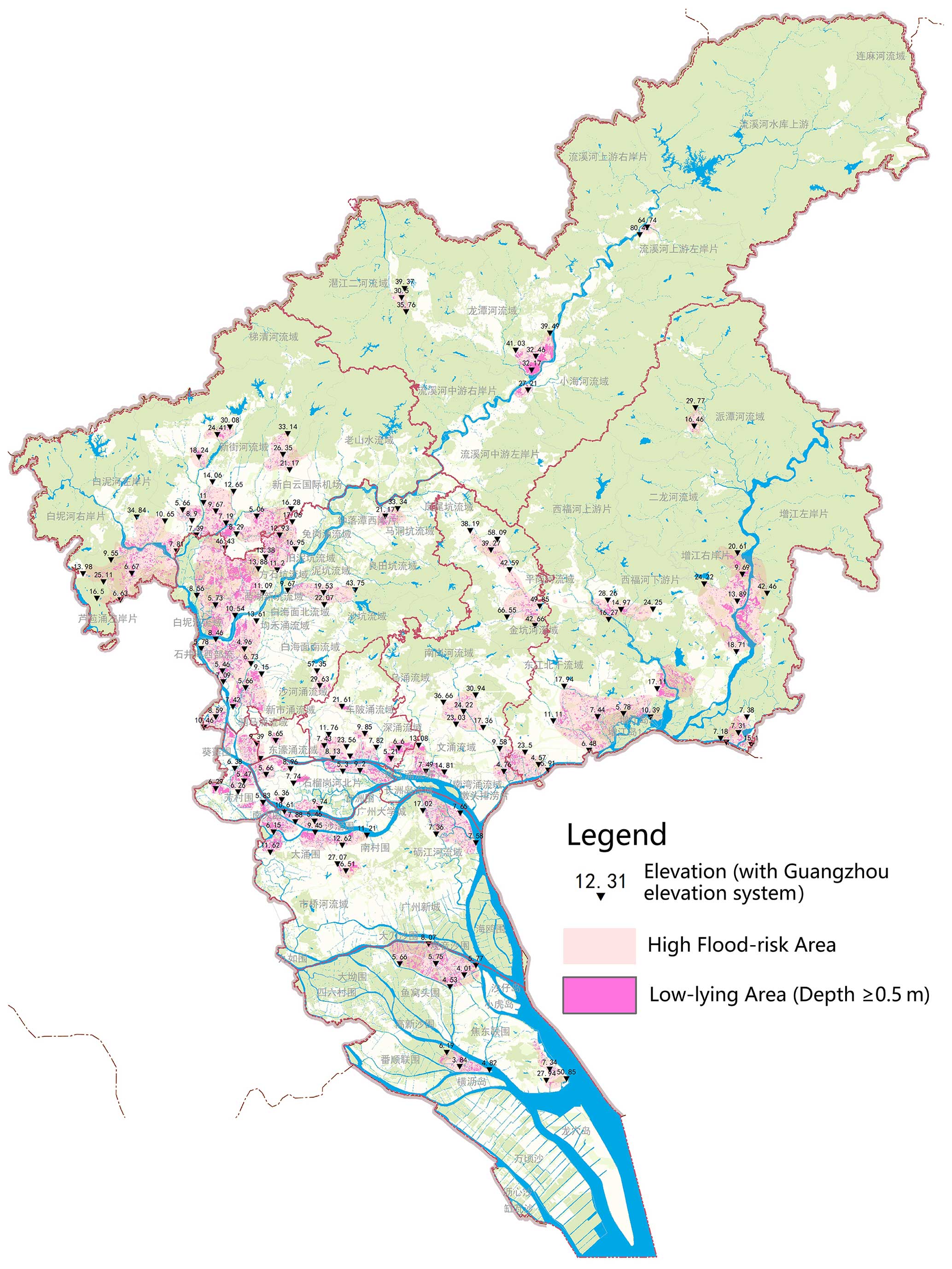
Figure 6Distribution of flood-risk areas in Guangzhou.
The area prone to rainstorm flooding is totally 772.84 km2, affecting about 4.8 million people. Rainstorm flood points in 2010 and 2020 were compared with the prone areas for verification. We found that, except the points caused by pipe plugging, inappropriate management and other reasons, rainstorm flood points are highly consistent with the designated high-rainstorm-flood-risk areas.
Guangzhou regards the delineation of rainstorm flood risk prone areas as the base of risk management and control, and regards the spatial requirements for storage, vertical design and facilities layout related to flood risk control as the rigid constraints of urban construction and the core elements of urban safety (Kuang, 2004).
4.1 Blue and green space management
The concept of blue and green space management has been promoted. Blue and green spaces have been reasonably delineated. Flood and drainage channels and rainstorm storage space has been reserved. The designated ecological control zone covers an area of 2680 km2, accounting for about 36 % of the city's total area. 38 blue lines of municipal main rivers and 17 protection lines of large and medium-sized reservoirs have been defined, and natural ecological spaces such as river and lake systems, woodland, grassland, wetland, waterfront space, green space and ecological corridor have been strictly protected, while the natural flood discharge channel and flood storage and detention area have been reserved.
4.2 River system management
According to the grade of rivers and lakes, the management scope of rivers and lakes are between 6 and 20 m. Strictly implement water requisition-compensation balance to ensure effective stormwater storage space. The planning department and the water department jointly delimit more than 1300 river management lines, take the delimited management area as the legal basis, and manage water in different levels (Administrative Measures for the Scope of the Urban Blue Line, 2006). New projects are not allowed to enter the management scope of rivers and lakes, and sufficient stormwater storage space is reserved (Fig. 7).
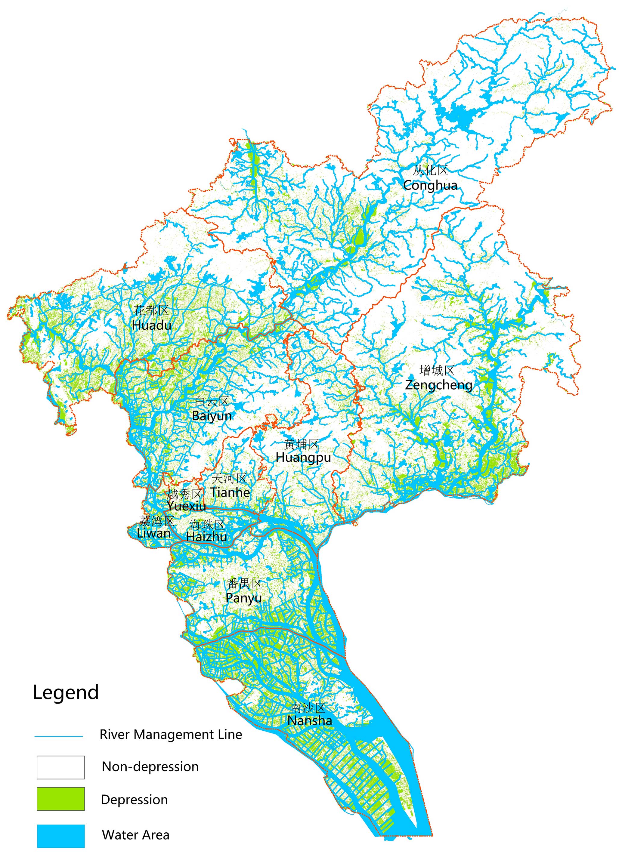
Figure 7Guangzhou River System.
4.3 Vertical elevation management
Vertical elevation is managed in concert with flood control systems. According to the designed flood level of the river, the vertical design requirements based on flood safety are clarified, and the vertical elevation control of the construction land is given priority in accordance with the principle that is conducive to rainwater removal.
For areas with ground elevation lower than the maximum flood level of 8.00 m along the Pearl River, different ground elevation control strategies should be adopted in different areas. In the southern coastal wetland area, the terrain is relatively low-lying, and the drainage method is combined with storage and drainage, and super levees are constructed to cope with the superposition of rainstorm and storm surge. In the central urban area, the drainage mode is mainly gravity flow.
4.4 Low impact development
Guangzhou divides the city into many cells, and reduce runoff of every cell by low impact development. A special section on low impact development is set up in regional planning. In the stages of land transfer and construction project planning permits, the requirements of low impact development should be clearly stated. The planning of each cell must reserve enough rainwater storage space to ensure the runoff control capacity (Zheng and Qin, 2022). The layout of rainwater storage space shall be shown on the planning drawing, which will become a legal basis map (Fig. 8).
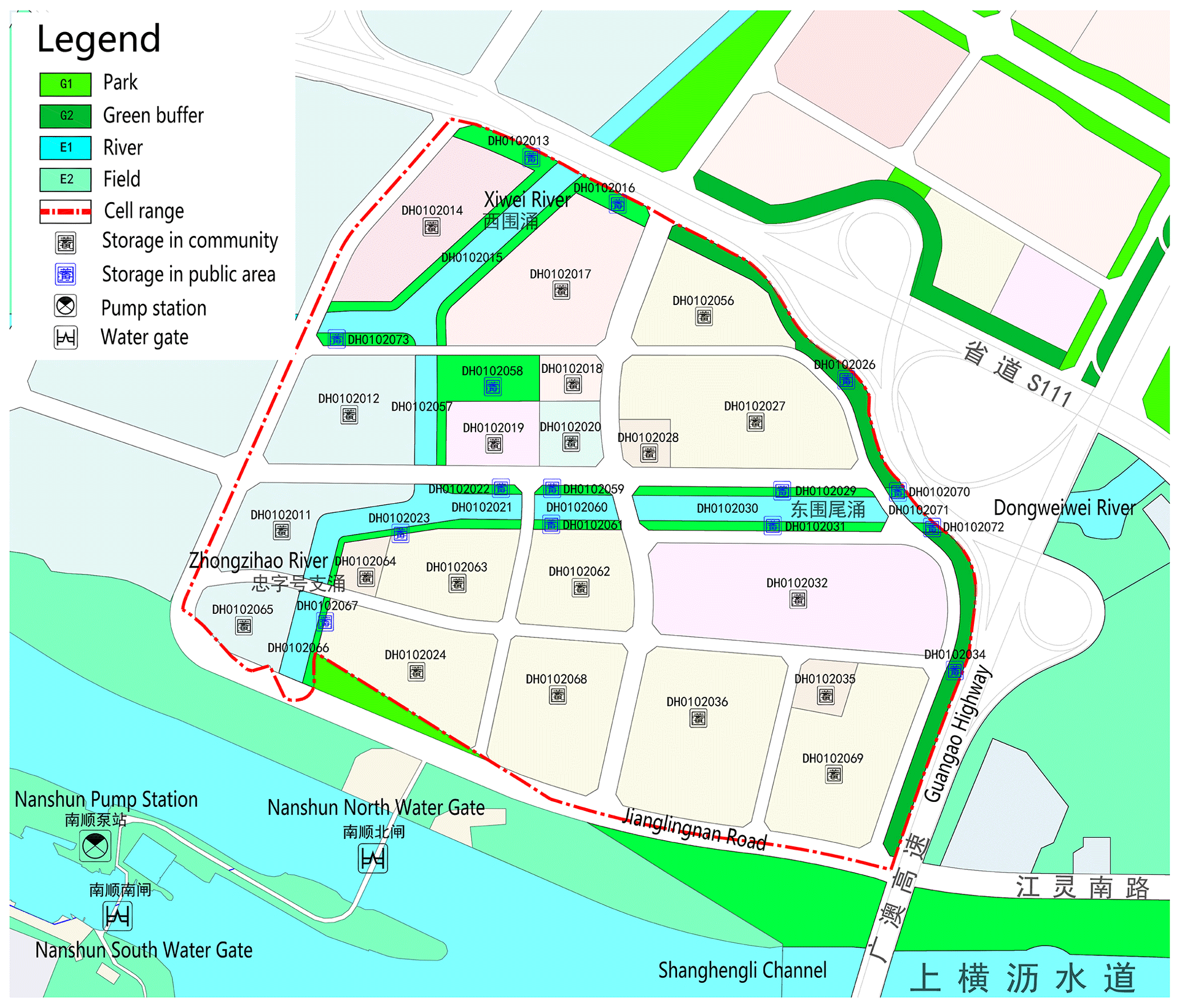
Figure 8An example of rainwater storages layout map.
In the pross of creating Lingnan eco-city with mountains and water, Guangzhou has controlled the source of urban flood and improved the rainstorm flood prevention capacity of the watershed.
5.1 Focus on the whole basin system flood risk assessment
Based on the flood risk assessment and analysis of plots, the subsequent focus should be on the flood risk assessment of river basins, and the water security content should be analyzed from the perspective of river basins, so as to improve the flood security of the region more systematically.
5.2 More closely coordinate the relationship between river management and land development
In urban planning and construction, the blue-green ecological space should be reasonably delineated, the use control of potential high-risk areas for waterlogging should be reasonably adjusted in combination with land use planning, and the relationship between river system and land development should be coordinated and optimized.
5.3 Detailed flood risk assessment on major infrastructure
Carrying out refined flood risk assessment in the early stage of major infrastructure such as tunnels, subways and culverts, identifying potential flood risk points, and improving the flood risk resistance of major infrastructure.
This paper mainly analyses Guangzhou rainstorm flood risk management experience in recent years. In the face of uncertain excessive rainfall, Guangzhou rainstorm flood governance practice innovation mainly embodied in:
Firstly, change the point from constructing engineering defence to building the flood risk control system, through the planning, construction control and improve management, which reduce the risk of rainstorm flood.
Secondly, institutional innovation. Guangzhou took the lead in establishing a transmission mechanism for rainstorm flood control in China, and implemented a flood risk assessment system at the stage of planning. Strictly protect the blue-green space, rationally control the intensity of urban development, use ecological rainstorm flood control measures in low impact development, and coordinate vertical elevation management with drainage system.
Thirdly, use the GIS and other technical means, and take watershed as the unit to identify the high rainstorm flood risk area accurately, which becomes the base of risk management and control.
This planning method has supported the Security and Resilience of Guangzhou's Territorial Spatial Planning, Urban Renewal, Guangzhou Sponge City Construction and other major planning and construction programs, and has been already applied and practiced to more than 100 flood risk assessment projects. Since the launch of the flood risk assessment system, a total of 17.66×10⁶ m3 of storage capacity has been implemented, equivalent to more than 170 small reservoirs.
The data are not publicly accessible. It is required in the analysis of rainstorm flood events of Guangzhou.
MK is responsible for the methodology development, project administration and supervision. YZ is responsible for the formal analysis, writing – original draft preparation and writing – review and editing. XD and YY are responsible for the conceptualization and funding acquisition. JW and XS are responsible for formal analysis. YP is responsible for the writing – review and editing.
The contact author has declared that none of the authors has any competing interests.
Publisher’s note: Copernicus Publications remains neutral with regard to jurisdictional claims made in the text, published maps, institutional affiliations, or any other geographical representation in this paper. While Copernicus Publications makes every effort to include appropriate place names, the final responsibility lies with the authors.
This article is part of the special issue “ICFM9 – River Basin Disaster Resilience and Sustainability by All”. It is a result of The 9th International Conference on Flood Management, Tsukuba, Japan, 18–22 February 2023.
This research has been supported by the Guangdong Enterprise Key Laboratory for Urban Sensing, Monitoring and Early Warning (grant no. 2020B121202019) and The Science and Technology Foundation of Guangzhou Urban Planning and Design Survey Research Institute (grant no. RDI220200205025).
This paper was edited by Miho Ohara and reviewed by two anonymous referees.
Administrative Measures for the Scope of the Urban Blue Line: http://www.gov.cn/fefg/2006-02/15/content_191814.htm (last access: 15 February 2006), 2006.
Ai, H. and Wu, X.: Variation Characteristics of Rainstorm in Guangzhou, Guangdong Meteorology, 40, 20–23, https://doi.org/10.3969/j.issn.1007-6190.2018.04.005, 2018.
Cheng, X.: Lessons and reflections from the case of Guojiazui Reservoir disaster caused by “7⋅20” extreme rainstorm disaster in Zhengzhou in 2021, China Flood and Drought Management, 32, 32–36, https://doi.org/10.16867/j.issn.1673-9264.2022043, 2022.
Cheng, X. and Li, C.: Evolution trend, important characteristics and countermeasures of urban flood risk, J. China Flood and Drought Management, 25, 6–9, https://doi.org/10.16867/j.cnki.cfdm.2015.03.002, 2015.
Guo, C. and Deng, L.: Analysis and Countermeasure of Waterlogging in Central Urban Area of Guangzhou, China Water and Wastewater, 27, 25–28, 2011.
Huang, H., Wang, X., and Liu, L.: A review on urban pluvial floods: Characteristics, mechanisms, data, and research methods, Progr. Geogr., 40, 1048–1059, https://doi.org/10.18306/dlkxjz.2021.06.014, 2021.
Kuang, M.: Forming a Natural Water System of River and River Branches in Urban Planning–Taking for Example the Sectional Design of the Rivers and River Branches in Guangzhou, Planners, 2004, 33–36, https://doi.org/10.3969/j.issn.1006-0022.2004.08.009, 2004.
Suggestions on strengthening urban waterlogging control: http://www.gov.cn/zhengce/content/2021-04/25/content_5601954.htm (last access: 25 April 2021), 2021.
Wang, M. and Wang, S.: Implication and Experience of Resilient City: A Case Study of New Orleans in the United States, Urban Development Studies, 25, 145–150, https://doi.org/10.3969/j.issn.1006-3862.2018.11.014, 2018.
Wang, T., Hu, L., and Chen, Z.: Causes and countermeasures of Guangzhou subway flooding caused by heavy rain on May 22 in 2020, Guangdong Meteorology, 42, 52–55, https://doi.org/10.3969/j.issn.1007-6190.2020.04.013, 2020.
Xia, J., Zhang, Y., Liang, C., and Liu, J.: Review of urban stormwater models, Engineering Journal of Wuhan University, 51, 95–105, https://doi.org/10.14188/j.1671-8844.2018-02-001, 2018.
Zhan, M., Wei, Z., Wang, J., Zhou, X., and Peng, D.: Urban physical examination evaluation methods and improvement strategies for territory space security: The case study of Guangzhou, Journal of Natural Resources, 36, 2382–2393, https://doi.org/10.31497/zrzyxb.20210915, 2021.
Zheng, Y. and Qin, H.: Hydrological Modeling of Low Impact Development Combined Facilities and Its Uncertainty Analysis, China Water & Wastewater, 38, 114–121, https://doi.org/10.19853/j.zgjsps.1000-4602.2022.01.018, 2022.