the Creative Commons Attribution 4.0 License.
the Creative Commons Attribution 4.0 License.
 | 18 Apr 2024
Uptake by end-users of a PUB approach made available as a Web Service
Tom Loree
Hervé Squividant
Josette Launay
Alban de Lavenne
Christophe Cudennec
A consolidated geomorphology-based approach for discharge hydrograph Prediction in Ungauged Basins (PUB) through deconvolution of discharge signals from gauged donor catchments, their transposition and their convolution towards target outlets, has been made available online to end-users through a Web Service (Web Processing Service Application Programming Interface – WPS API) for the synoptic peninsular region of Brittany, France. In the spirit of hydrological services, the SIMFEN Web Service allows anyone to execute the hydrological modelling online through OGC® interoperability standards; collection of public hydrometric data; connection to a pre-existing Web Service for geomorphometric analysis; and online visualization. Thanks to tangible indicators, we here show how the users' community is actually active in using the Web Service, i.e. in uptaking the recent science-operational translation of a scientific development into a Service.
- Article
(1928 KB) - Full-text XML
- BibTeX
- EndNote


UPH 7; UPH 21; UPH 22; PUB; Hydrogeomorphology; Science-Solution; Brittany
In hydrology, scientific knowledge and methodological progress are critical for society in terms of security and sustainable development, polycentric governance and citizen engagement (Young et al., 2015; Ceola et al., 2016; Di Baldassarre et al., 2019; Nardi et al., 2022). Scientific outcomes in terms of methodology have always had a high innovative potential for different end-users including operational hydrometeorological entities, water management institutions, and policy makers. The translation of methods into Services (WMO, 2015) is a major challenge which can be inscribed in the hydro-informatic side of Open Science (UNESCO, 2021; Cudennec et al., 2022b) in terms of data FAIRness and relevance (see Cudennec et al., 2020 on FAIR and SQUARE data; Pecora and Lins, 2020 on e-monitoring the nature of water; Hall et al., 2022), of efficient workflows and chainings (Cudennec et al., 2022a), and of operationalization and assimilation of innovations (Dixon et al., 2022). The scientific work is naturally valued through scientific publications with its own rules and metrics, yet the translation into innovation towards end-users needs to go beyond scientific publications and bibliometrics (Cudennec and Hubert, 2008; Koutsoyiannis et al., 2016; Cudennec et al., 2022b). Here we illustrate how a consolidated modelling approach of the PUB – Prediction in Ungauged Basins type has been translated into a Web Service (Web Processing Service Application Processing Interface – WPS API) and how indicators of use can be considered.
Prediction in Ungauged Basin (PUB) remains an ambitious task, especially when dealing with discharge series, i.e. hydrographs and derived statistics of regime (Blöschl et al., 2013; Hrachowitz et al., 2013) and related signatures (McMillan, 2021). For any gauged basin, Cudennec (2000) proposed the inversion of a geomorphology-based transfer function and so the deconvolution of the measured discharge time series to assess the net rainfall time series. The simulated discharge time series at the outlet of a similar target catchment (in particular nested or neighbouring) is then obtained by transposition from the donor catchment, then the convolution with the corresponding transfer function as deduced from its observed geomorphometry and a robust assumption on the streamflow velocity. This geomorphology-based hydrological approach (Cudennec, 2007) has been tested in different well described contexts with pseudo-ungauged strategies: semi-arid Tunisia (Boudhraâ et al., 2009, 2018), temperate oceanic France (de Lavenne et al., 2015, 2016) and pluvio-nival Canadian Québec (Ecrepont et al., 2019). Robustness has been assessed regarding the calibration configuration (Boudhraâ et al., 2018; de Lavenne et al., 2016) and the resolution of the digital elevation model used as a geomorphometric reference (Ecrepont and Cudennec, 2020). Based on these grounds, simulations in truly ungauged catchments have been performed, in particular towards coastal bays (de Lavenne and Cudennec, 2019), which are water quality-related hotspots (Heal et al., 2021; Neville et al., 2022), being fragile fresh/marine water ecosystems where water-conveyed nutrient over-loads can induce eutrophication and green tides.
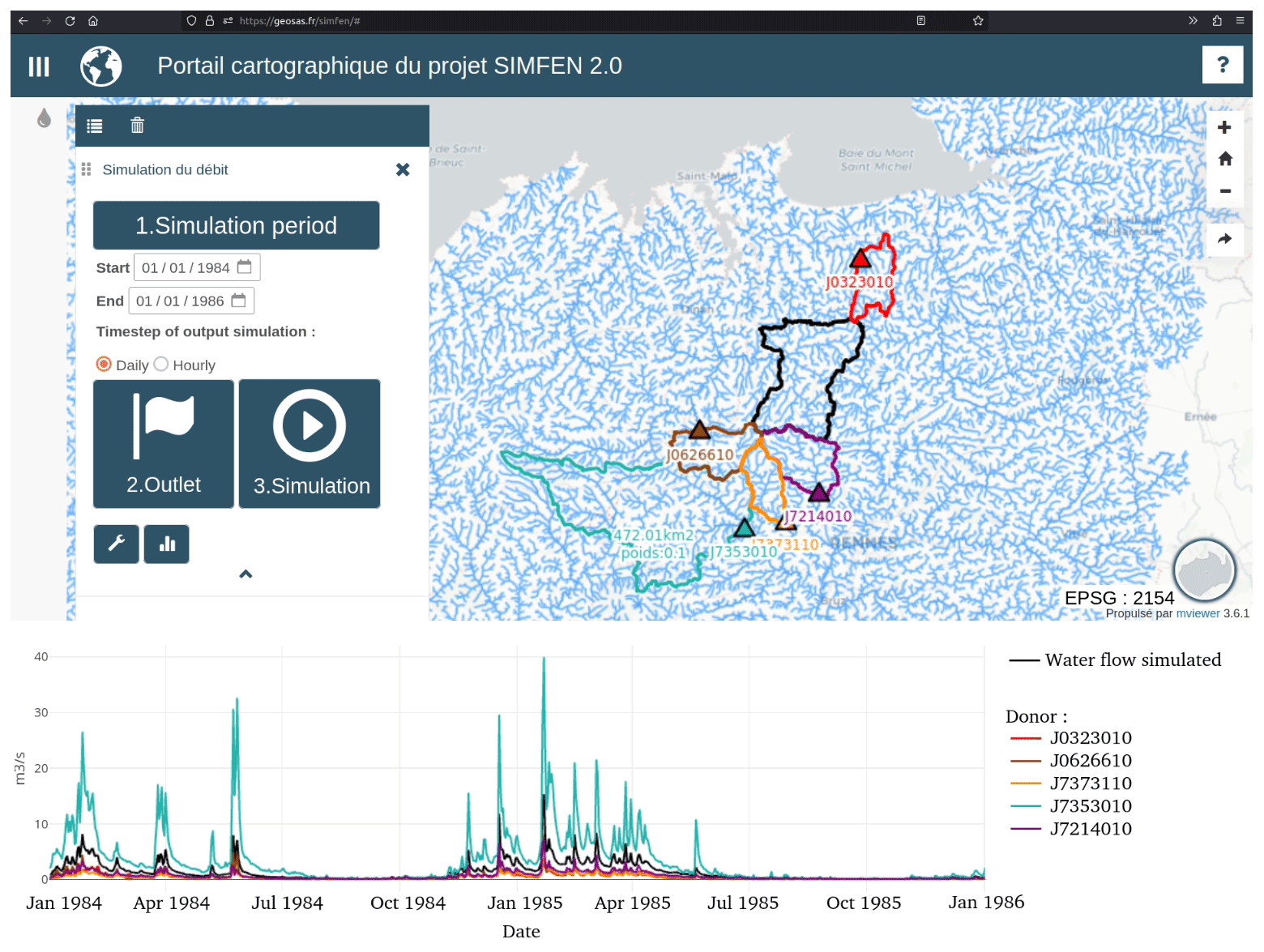
Figure 1Screenshot of the SIMFEN Web Service interface with simulated discharge for a target catchment (black in the time series and on the map) obtained by transposing observed discharges from five surrounding gauging stations (donor catchments, in colour: J0323010, J0626610, J7373110, J7353010, J7214010).
This consolidated geomorphology-based approach for discharge Prediction in Ungauged Basins (PUB) through deconvolution of discharge signals from gauged donor catchments, their transposition and their convolution towards target outlets, has been made available online to end-users through a Web Processing Service Application Programming Interface (WPS API) for the synoptic peninsular region of Brittany, France. In the spirit of hydrological Services, the SIMFEN WPS API (https://geosas.fr/simfen, last access: 10 March 2023, Dallery et al., 2022) allows anyone to execute the hydrological modelling package transfR (de Lavenne et al., 2021, 2023) online through: (1) Open Geospatial Consortium (OGC®) interoperability standards; (2) collection and use of public hydrometric data; (3) connection to the pre-existing MNTSurf WPS API for geomorphometric analysis (Squividant et al., 2015); (4) visualization using a collaboratively developed Mviewer; and (5) innovative WPS API chaining workflows facilitated by an Open Science spatial data infrastructure (Bera et al., 2015). The ability to model discharge series at any ungauged outlet of the synoptic region is offered to specialists of other disciplines, non-modeller water practitioners and interested citizens to support interdisciplinarity, water monitoring and management, and related science-society-policy debates and actions. Figure 1 illustrates the SIMFEN Web Service through its online interface.
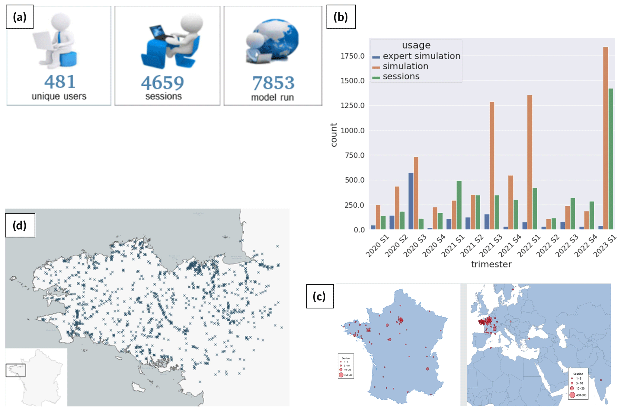
Figure 2End-using indicators of the SIMFEN Web Service API over 1 January 2020–9 February 2023 period. Overall (a) and sequential (b) usage; Mapping of users (c) and catchment outlets (d).
The modelling approach had been used and presented in different catchments across the Brittany region (a coherent hydrographic area of 29 640 km2 – Fig. 2a), with corresponding stakeholders over the last decade; but the expertise was sitting with the scientific team, whereas the demand for tailored simulations was increasingly soliciting. The principle of the SIMFEN Web Service was envisaged with key stakeholders, i.e. the Brittany regional government (Région Bretagne) and the corresponding water basin institution (Agence de l'Eau Loire Bretagne) which funded the development. The SIMFEN Web Service was beta-tested with a sample of end-users in 2019 (Dallery et al., 2022) and was then opened to end users late 2019. A public announcement was made via the different communication vehicles of the scientific team, the funders, and the regional CRESEB network for science-policy dialogue in the field of water. Beyond the water-related stakeholders, announcements and demonstrations were made within the regional GeoBretagne community dealing with data sharing. These multichannel advertisements have then been amplified and consolidated via a dedicated webinar presentation on 20 June 2021 (https://www.creseb.fr/cycle-webinaire-hmuc/, last access: 10 March 2023), incorporation in teaching at master level, and a constructive hotline interaction with pro-active end-users.
Figure 2 displays different indicators, of the metric and mapping types, of end-using between 1 January 2020 and 9 February 2023. Assessing these indicators is allowed by the digital monitoring of the Web Service actioning. The ultimate use of the simulations obtained cannot be fully captured by the digital monitoring, and the trial-and-error or expert-exploration iterations cannot be easily detected and accounted for. Yet informal feedbacks from end-users, announced and detected specific analysis works led by water institutions, consulting companies, sometimes seconded to master students from curricula where the modelling method and Service had been presented and explored, confirm that many end-users are really considering the Service beyond curiosity. Many have a real strategy for testing and subsequently for supporting operational and policy developments, in particular regarding the consolidation of the hydrometric network, the alignment of water quantity and quality monitoring, and gap filling in data series and/or in catchment-wide approaches for water resources management, and for the assessment of hydrological driving forces of specific ecosystems. A more ambitious assessment of the Service-using is under consideration, which will develop on and beyond indicators displayed in Fig. 2. Yet, it is already obvious that the end-using is much more intense than it was and would have remained if the methodological development had been kept limited to the scientific team and to publications in scientific journals.
The code has been made available as a R package by de Lavenne et al. (2021) at https://doi.org/10.57745/ZYNPKQ.
Data used in this article are freely accessible through the SIMFEN Web Service (https://geosas.fr/simfen, SIMFEN, 2023).
CC designed the objectives and funding. AdL developed the modelling package. TL and HS developed the Web Service and User interface. JL organized the relationships with partners. All iterated on the Web Service design. CC drafted the article. TL, HS, JL and AdL contributed to the article refinement.
At least one of the (co-)authors is a guest member of the editorial board of Proceedings of IAHS for the special issue “IAHS2022 – Hydrological sciences in the Anthropocene: Past and future of open, inclusive, innovative, and society-interfacing approaches”. The peer-review process was guided by an independent editor, and the authors also have no other competing interests to declare.
Publisher’s note: Copernicus Publications remains neutral with regard to jurisdictional claims in published maps and institutional affiliations.
This article is part of the special issue “IAHS2022 – Hydrological sciences in the Anthropocene: Past and future of open, inclusive, innovative, and society-interfacing approaches”. It is a result of the XIth Scientific Assembly of the International Association of Hydrological Sciences (IAHS 2022), Montpellier, France, 29 May–3 June 2022.
This research has been supported by the Conseil Régional de Bretagne and Agence de l'Eau Loire Bretagne.
This paper was edited by Salvatore Grimaldi and reviewed by two anonymous referees.
Bera, R., Squividant, H., Le Henaff, G., Pichelin, P., Ruiz, L., Launay, J., Vanhouteghem, J., Aurousseau, P., and Cudennec, C.: GéoSAS: A modular and interoperable Open Source Spatial Data Infrastructure for research, Proc. IAHS, 368, 9–14, https://doi.org/10.5194/piahs-368-9-2015, 2015.
Blöschl, G., Sivapalan, M., Wagener, T., Viglione, A., and Savenije, H.: Runoff Prediction in Ungauged Basins: Synthesis across Processes, Places and Scales, Cambridge University Press, Cambridge, https://doi.org/10.1017/CBO9781139235761, 2013.
Boudhraâ, H., Cudennec, C., Slimani, M., and Andrieu H.: Hydrograph transposition between basins through a geomorphology-based deconvolution-reconvolution approach, IAHS Publ., 333, 76–83, 2009.
Boudhraâ, H., Cudennec, C., Andrieu, H., and Slimani, M.: Net rainfall estimation by the inversion of a geomorphology-based transfer function and discharge deconvolution, Hydrolog. Sci. J., 63, 285–301, https://doi.org/10.1080/02626667.2018.1425801, 2018.
Ceola, S., Montanari, A., Krueger, T., Dyer, F., Kreibich, H., Westerberg, I., Carr, G., Cudennec, C., Elshorbagy, A., Savenije, H., van der Zaag, P., Rosbjerg, D., Aksoy, H., Viola, F., Petrucci, G., MacLeod, K., Croke, B., Ganora, D., Hermans, L., Polo, M. J., Xu, Z., Borga, M., Helmschrot, J., Toth, E., Ranzi, R., Castellarin, A., Hurford, A., Brilly, M., Viglione, A., Blöschl, G., Sivapalan, M., Domeneghetti, A., Marinelli, A., and Di Baldassarre, G.: Adaptation of water resources systems to changing society and environment – A statement by the International Association of Hydrological Sciences, Hydrolog. Sci. J., 61, 2803–2817, https://doi.org/10.1080/02626667.2016.1230674, 2016.
Cudennec, C.: Description mathématique de l'organisation du réseau hydrographique et modélisation hydrologique, PhD, ENSA Rennes, 2000.
Cudennec, C.: On width function-based unit hydrographs deduced from separately random self-similar river networks and rainfall variability, Hydrolog. Sci. J., 52, 230–237, https://doi.org/10.1623/hysj.52.1.230, 2007.
Cudennec, C. and Hubert, P.: Multi-objective role of HSJ in processing and disseminating hydrological knowledge, Hydrolog. Sci. J., 53, 485–487, https://doi.org/10.1623/hysj.53.2.485, 2008.
Cudennec, C., Lins, H., Uhlenbrook, S., and Arheimer, B.: Towards FAIR and SQUARE hydrological data, Hydrolog. Sci. J., 65, 681–682, https://doi.org/10.1080/02626667.2020.1739397, 2020.
Cudennec, C., Lins, H., Uhlenbrook, S., Amani, A., and Arheimer, B.: Operational, epistemic and ethical value chaining of hydrological data to knowledge and services: a watershed moment, Hydrolog. Sci. J., 67, 2363–2368, https://doi.org/10.1080/02626667.2022.2150380, 2022a.
Cudennec, C., Sud, M., and Boulton, G.: Governing Open Science, Hydrolog. Sci. J., 67, 2359–2362, https://doi.org/10.1080/02626667.2022.2086462, 2022b.
Dallery, D., Squividant, H., de Lavenne, A., Launay, J., and Cudennec, C.: An end-user-friendly hydrological Web Service for hydrograph Prediction in Ungauged Basins, Hydrolog. Sci. J., 67, 2420–2428, https://doi.org/10.1080/02626667.2020.1797045, 2022.
de Lavenne, A. and Cudennec, C.: Assessment of freshwater discharge into a coastal bay through multi-basin ensemble hydrological modelling, Sci. Total Environ., 669, 812–820, https://doi.org/10.1016/j.scitotenv.2019.02.387, 2019.
de Lavenne, A., Boudhraâ, H., and Cudennec, C.: Streamflow prediction in ungauged basins through geomorphology-based hydrograph transposition, Hydrol. Res., 46, 291–302, https://doi.org/10.2166/nh.2013.099, 2015.
de Lavenne, A., Skøien, J. O., Cudennec, C., Curie, F., and Moatar, F.: Transferring measured discharge time series: Large-scale comparison of Top-kriging to geomorphology-based inverse modeling, Water Resour. Res., 52, 5555–5576, https://doi.org/10.1002/2016WR018716, 2016.
de Lavenne, A., Loree, T., Squividant, S., and Cudennec, C.: transfR: Transfer of Hydrograph from Gauged to Ungauged Catchments, R package version 0.1.0, Recherche Data Gouv [code], https://doi.org/10.57745/ZYNPKQ, 2021.
de Lavenne, A., Loree, T., Squividant, H., and Cudennec, C.: The transfR toolbox for transferring observed streamflow series to ungauged basins based on their hydrogeomorphology, Environ. Model. Softw., 159, 105562, https://doi.org/10.1016/j.envsoft.2022.105562, 2023.
Di Baldassarre, G., Sivapalan, M., Rusca, M., Cudennec, C., Garcia, M., Kreibich, H., Konar, M., Mondino, E., Mård, J., Pande, S., Sanderson, M. R., Tian, F., Viglione, A., Wei, J., Wei, Y., Yu, D. J., Srinivasan, V., and Blöschl, G.: Socio-hydrology: Scientific challenges in addressing the sustainable development goals, Water Resour. Res., 55, 6327–6355, https://doi.org/10.1029/2018WR023901, 2019.
Dixon, H., Sandström, S., Cudennec, C., Lins, H., Abrate, T., Bérod, D., Chernov, I., Ravalitera, N., Sighomnou, D., and Teichert, F.: Intergovernmental cooperation for hydrometry – what, why, how?, Hydrolog. Sci. J., 67, 2552–2566, https://doi.org/10.1080/02626667.2020.1764569, 2022.
Ecrepont, S. and Cudennec, C.: Geomorphometry-based modelling of discharge series in ungauged basins – Robustness regarding DEM sources, Proc. IAHS, 383, 129–134, https://doi.org/10.5194/piahs-383-129-2020, 2020.
Ecrepont, S., Cudennec, C., Anctil, F., and Jaffrézic, A.: PUB in Québec: A robust geomorphology-based deconvolution-reconvolution framework for the spatial transposition of hydrographs, J. Hydrol., 570, 378–392, https://doi.org/10.1016/j.jhydrol.2018.12.052, 2019.
Hall, C. A., Saia, S. M., Popp, A. L., Dogulu, N., Schymanski, S. J., Drost, N., van Emmerik, T., and Hut, R.: A hydrologist's guide to open science, Hydrol. Earth Syst. Sci., 26, 647–664, https://doi.org/10.5194/hess-26-647-2022, 2022.
Heal, K. V., Bartosova, A., Hipsey, M. R., Chen, X., Buytaert, W., Li, H.-Y., McGrane, S. J., Gupta, A. B., and Cudennec, C.: Water quality: the missing dimension of water in the water-energy-food nexus?, Hydrolog. Sci. J., 66, 745–758, https://doi.org/10.1080/02626667.2020.1859114, 2021.
Hrachowitz, M., Savenije, H. H. G., Blöschl, G., McDonnell, J. J., Sivapalan, M., Pomeroy, J. W., Arheimer, B., Blume, T., Clark, M. P., Ehret, U., Fenicia, F., Freer, J. E., Gelfan, A., Gupta, H. V., Hughes, D. A., Hut, R. W., Montanari, A., Pande, S., Tetzlaff, D., Troch, P. A., Uhlenbrook, S., Wagener, T., Winsemius, H. C., Woods, R. A., Zehe, E., and Cudennec, C.: A decade of Predictions in Ungauged Basins (PUB) – a review, Hydrolog. Sci. J., 58, 1198–1255, https://doi.org/10.1080/02626667.2013.803183, 2013.
Koutsoyiannis, D., Blöschl, G., Bardossy, A., Cudennec, C., Hughes, D., Montanari, A., Neuweiler, I., and Savenije H.: Joint editorial – Fostering innovation and improving impact assessment for journal publications in hydrology, Water Resour. Res., 52, 2399–2402, https://doi.org/10.1002/2016WR018895, 2016.
McMillan, H. K.: A review of hydrologic signatures and their applications, WIREs Water, 8, e1499, https://doi.org/10.1002/wat2.1499, 2021.
Nardi, F., Cudennec, C., Abrate, T., Allouch, C., Annis, A., Assumpção, T. H., Aubert, A. H., Bérod, D., Braccini, A. M., Buytaert, W., Dasgupta, A., Hannah, D. M., Mazzoleni, M., Polo, M. J., Sæbø, Ø, Seibert, J., Tauro, F., Teichert, F., Teutonico, R., Uhlenbrook, S., Wahrmann Vargas, C., and Grimaldi, S.: Citizens AND HYdrology (CANDHY): conceptualizing a transdisciplinary framework for citizen science addressing hydrological challenges, Hydrolog. Sci. J., 67, 2534–2551, https://doi.org/10.1080/02626667.2020.1849707, 2022.
Neville, J. A., Guz, J., Rosko, H. M., and Owens, M. C.: Water quality inequality: a non-targeted hotspot analysis for ambient water quality injustices, Hydrolog. Sci. J., 67, 1011–1025, https://doi.org/10.1080/02626667.2022.2052073, 2022.
Pecora, S. and Lins, H. F.: E-monitoring the nature of water, Hydrolog. Sci. J., 65, 683–698, https://doi.org/10.1080/02626667.2020.1724296, 2020.
SIMFEN: Portrail cartographique du projet SIMFEN 2.0, SIMFEN [data set], https://geosas.fr/simfen, last access: 10 March 2023.
Squividant, H., Bera, R., Aurousseau, P., and Cudennec, C.: Online watershed boundary delineation: sharing models through Spatial Data Infrastructures, Proc. IAHS, 368, 144–149, https://doi.org/10.5194/piahs-368-144-2015, 2015.
UNESCO: Recommendation on Open Science, https://unesdoc.unesco.org/ark:/48223/pf0000379949.locale=en (last access: 10 March 2023), 2021.
WMO: Valuing weather and climate: economic assessment of meteorological and hydrological services, Geneva, Switzerland: World Meteorological Organization, 2015.
Young, G., Demuth, S., Mishra, A., and Cudennec, C.: Hydrological sciences and water security: An overview, Proc. IAHS, 366, 1–9, https://doi.org/10.5194/piahs-366-1-2015, 2015.
- Abstract
- Keywords
- Introduction
- SIMFEN: A Web Service to make a PUB modelling approach available
- Dissemination and indicators of use by end-users
- Code availability
- Data availability
- Author contributions
- Competing interests
- Disclaimer
- Special issue statement
- Financial support
- Review statement
- References