the Creative Commons Attribution 4.0 License.
the Creative Commons Attribution 4.0 License.
 | 16 Apr 2026
Spatial estimation of land loss in Zou catchment area at Atchérigbé outlet (Benin center)
Renaud Jean-Eudes Tundé Mitchozounou
Brunelle Eunice Toyin Icoutchika
Tchihoundro Gilbert Danhossou
Sessi Victaurya Eurydice Zinzindohoue
Davy Fifamè Karine Kodji
Soil degradation constitutes a major constraint for sustainable agricultural development, particularly in extension zones where land resources are under increasing pressure. This study evaluates soil loss and erosion sensitivity within the Zou watershed at the Atchérigbé outlet. The analysis integrated SRTM Digital Elevation Models (30 m, 2023), Landsat OLI TIRS 09 imagery (scenes 192-054 and 191-055, from 2018 to 2023), rainfall data from 1986 to 2021 provided by METEO BENIN, and FAO soil data. Soil loss was quantified using the Universal Soil Loss Equation (USLE), which combines rainfall erosivity (R), soil erodibility (K), the topographic factor (LS), and the vegetation cover factor (C) derived from supervised land cover classification. Five classes of erosion sensitivity were identified with in average 54 t ha−1 yr−1. Very low and low sensitivity zones dominate the watershed, covering 97 % and 2 % of the area, respectively. Medium-sensitivity areas (0.21 %) form a longitudinal band across the basin, while high-sensitivity areas (0.29 %) occur mainly in the western sector. Very high sensitivity zones (0.013 %) are localized in slope failure sites. These spatial patterns underscore the heterogeneous nature of erosion processes and their potential impacts on agricultural productivity, biodiversity, and ecosystem stability. While the USLE provides a robust framework for large-scale erosion assessment, its application remains constrained by sensitivity to input data accuracy and limited suitability under extreme conditions. Nevertheless, the results offer critical insights for watershed management. To mitigate ongoing land degradation, the study emphasizes the necessity of compensatory reforestation and the adoption of sustainable land management practices.
- Article
(5838 KB) - Full-text XML
- BibTeX
- EndNote


Soil erosion constitutes one of the most critical forms of land degradation in sub-Saharan Africa, significantly affecting agricultural productivity, soil fertility, biodiversity, and long-term ecosystem resilience (Lal, 2001). In West Africa, and particularly in Benin, increasing rainfall intensity associated with climate variability, combined with rapid agricultural expansion and unsustainable land management practices, has accelerated soil loss processes in many watersheds.
The Zou watershed in central Benin represents a highly vulnerable environment due to its strong agricultural pressure, heterogeneous soil types, and variable topography that enhances runoff generation and sediment transport. Previous studies conducted in the region (Akplo et al., 2020; Houngnandan et al., 2019; Akplo et al., 2021) have assessed soil erosion risk using empirical approaches and highlighted the influence of rainfall erosivity, soil erodibility, slope gradient, and land cover dynamics. However, these studies present several limitations. First, many assessments were conducted at coarse spatial resolutions, limiting their capacity to support local-scale land management decisions. Second, some analyses relied on generalized or outdated land cover and rainfall datasets, which may not capture recent environmental and land-use changes. Third, few studies have specifically focused on the Atchérigbé outlet of the Zou watershed, where sediment export directly impacts downstream hydrological and agricultural systems.
Despite the growing body of literature, there remains a need for updated, high-resolution spatial assessments that integrate recent topographic, climatic, and land-use data to better identify priority areas for intervention. Therefore, the core problem addressed in this study is the lack of fine-scale, spatially explicit erosion estimates at the Atchérigbé outlet capable of supporting targeted watershed management and soil conservation planning.
To address this gap, this study applies the Universal Soil Loss Equation (USLE) model (Renard et al., 1997), an empirical and spatially adaptable framework widely used in data-scarce regions. The USLE was selected for several reasons. First, it requires relatively accessible inputs rainfall data, soil properties, topography derived from DEM, and land cover information which are available for the study area. Second, it has been extensively validated in tropical and sub-tropical environments, including West Africa, making it suitable for comparative regional studies (Nearing et al., 2017). Third, its integration within a GIS environment allows spatially distributed estimation of erosion risk, which is essential for watershed-scale planning.
The novelty of this study lies in: the production of an updated, high-resolution erosion risk map for the Zou watershed at the Atchérigbé outlet using recent DEM and Landsat data; the integration of recent rainfall chronicles to better represent current erosivity patterns; the focus on a hydrologically strategic outlet zone where sediment yield has direct downstream implications and the generation of spatial decision-support information aimed at guiding sustainable land and watershed management strategies in central Benin.
By providing a refined spatial assessment of land loss and identifying erosion-sensitive hotspots, this study contributes new empirical evidence to improve soil conservation prioritization and watershed resilience planning in Benin and similar West African agroecological contexts.
The Zou basin at Atchérigbé covers an average area of 6950 km2. It lies between 7°14′30′′ and 8°33′52′′ North latitude and 1°30′58′′ and 2°13′32′′ East longitude. Figure 1 shows the geographical location of the Zou River basin.
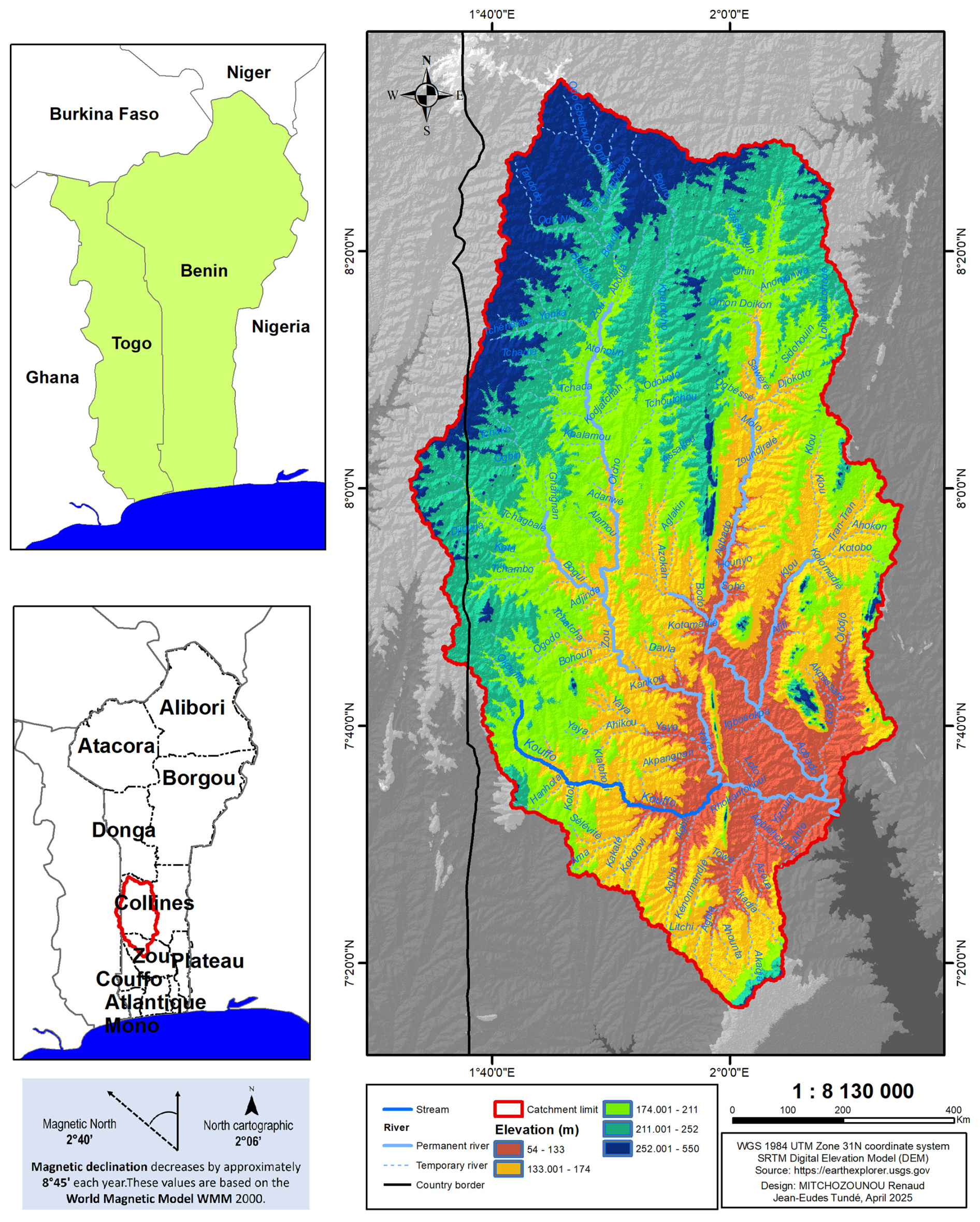
Figure 1Location map of the study area.
The data used during this study are satellite image and climate data. The satellite image are: Digital Elevation Model (DEM) who is used to calculate topographic parameters and the Landsat Oli Tirs 09 image over 6 years (2018 to 2023) of scene 192-054 and 191-055, they are downloaded from the USGS official website (https://earthexplorer.usgs.gov, last access: 28 April 2024) who are used extract land use and to calculate Normalized Difference Vegetation Index (NDVI). The soil erodibility data comes from the FAO database. The climate data consist of daily precipitation records over the period 1986–2021 from rainfall stations across the basin (Pira, Bantè, Gouka, Savalou, Tchetti, Dassa-Zoumè and Agouna). They come from the METEO Benin database.
3.1 Method about Vegetation cover treatment
The Normalized Vegetation Index (NDVI) is used to quantify the health and density of plants. It is calculated using Landsat Oli 09 satellite images, specifically the red and infrared bands. During the data processing, the Landsat image was treated by radiometric and atmospheric correction. NDVI is determined by the following expression:
Where: NIR: Near Infrared Band (B5); Red: Red Band (B4).
3.2 Method about land loss mapping
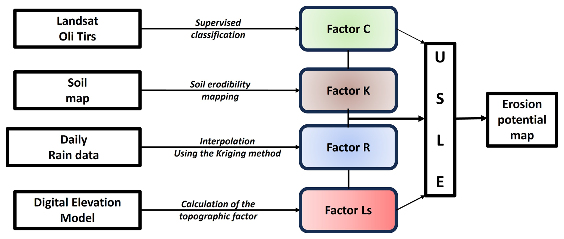
In this study, the method used to map land loss is the Universal Soil Loss Equation (USLE). The USLE was adopted in this study because it provides a robust, empirically validated, and GIS-compatible approach for estimating long-term average soil erosion, integrating key climatic, topographic, soil, and land-use factors while requiring relatively limited data inputs. The Universal Soil Loss Equation (Wischmeier and Smith, 1978a; Renard et al., 1997) remains, by far, the most widely used mathematical erosion prediction model due to its ease of application and ease of data acquisition. Integrating thematic maps of the factors of this model into the GIS made it possible to identify the impact of each factor on soil loss, to classify erosion zones by relative importance, and to quantify soil loss (Sadiki et al., 2004; Wachal and Banks, 2007). The USLE is based on several natural factors that govern the land loss process, including topographic factor, rainfall factor (processed by kriging interpolation method), soil factor, and vegetation cover factor. It is expressed in the following form:
Where: A = Soil loss rate (t ha−1 yr−1); R = Rainfall erosivity (MJ mm ha−1 h−1 yr−1); K = Soil erodibility (t h ha−1 MJ−1 mm−1); LS = Topographic factor (L in m, S in %); C = Vegetation cover.
Figure 2 shows the data source and the way we combined each of factors mentioned earlier.
During our study, the data was processed with Surfer (Version 11) for rain fall data interpolation, QGIS 3.16 for GIS and mapping and Positron (using R language) to compute the plot.
4.1 Change analysis on Vegetation cover
During our study, vegetation changes were analyzed using Landsat Oli Tirs 09 images and the Normalized Difference Vegetation Index (NDVI). Figure 3 shows the NDVI values between 2018 and 2023 for the study area.
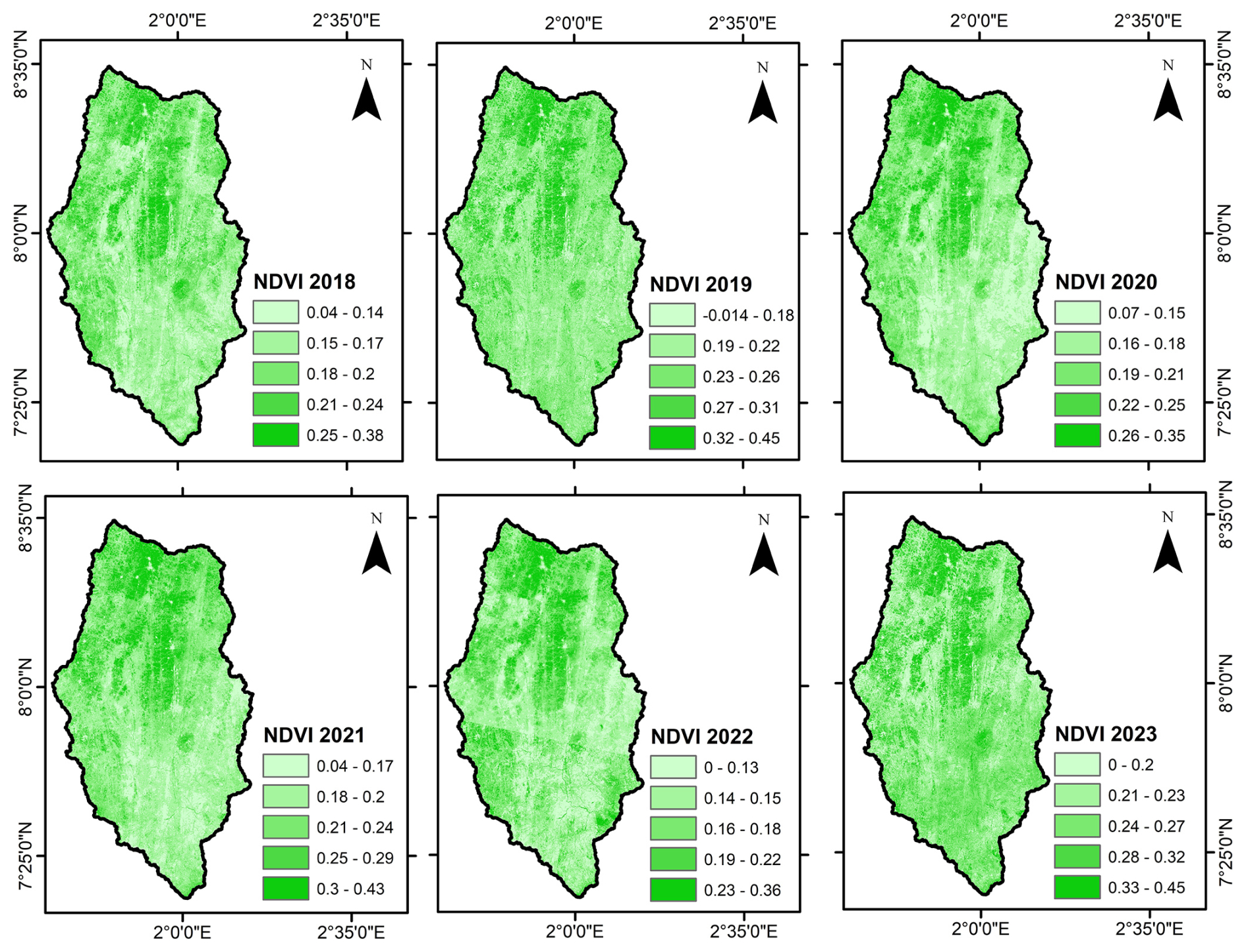
Figure 3Spatial distribution of the vegetation index.
The spatial and temporal distribution of NDVI values across the basin is not stable, having undergone changes from one year to the next. The condition of vegetation in the northern part of the basin deteriorated between 2018 and 2023. This was also observed in the south-western part of the study area. The extracted NDVI values were compared in pairs using the linear regression method. The scatter plots and regression lines are shown in Fig. 4.
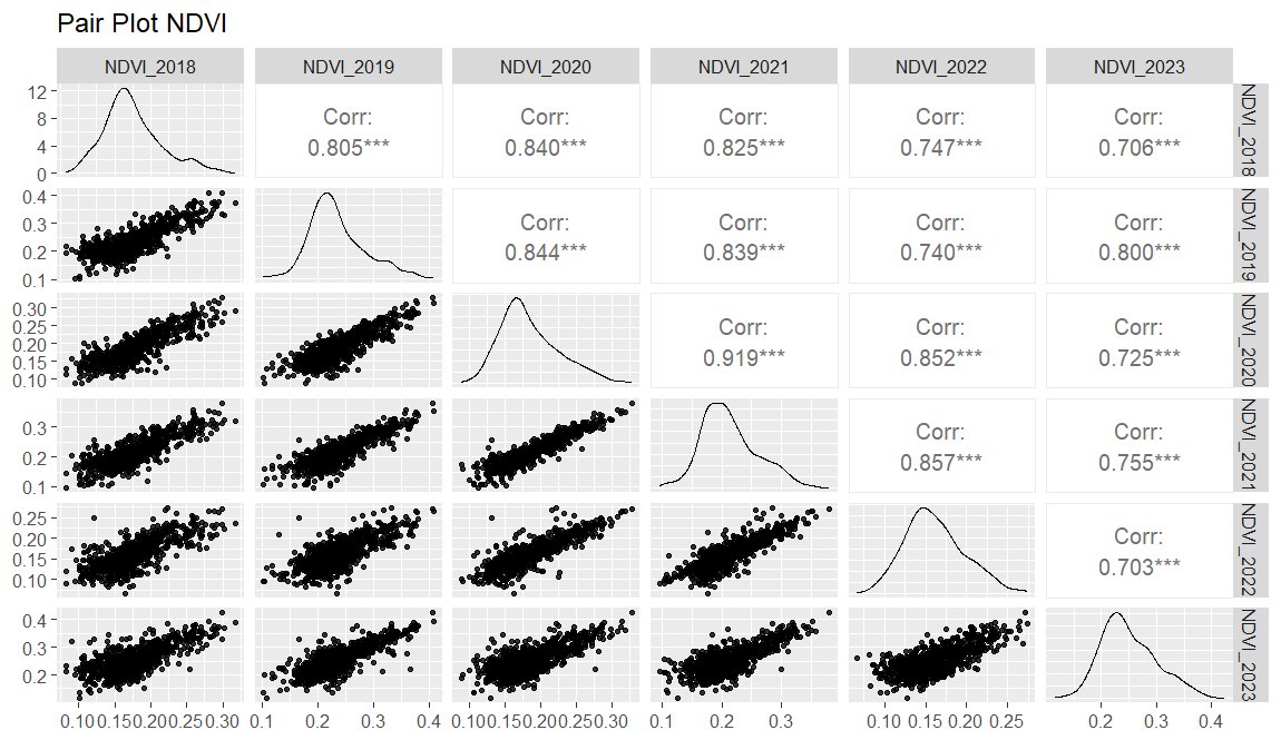
Interannual NDVI comparisons show consistently strong and statistically significant correlations across the study period. NDVI in 2018 is strongly correlated with 2019 (r = 0.805), 2020 (r = 0.840), 2021 (r = 0.825), 2022 (r = 0.747), and 2023 (r = 0.706). Similarly, NDVI in 2019 exhibits high correlations with 2020 (r = 0.844), 2021 (r = 0.839), 2022 (r = 0.740), and 2023 (r = 0.800). NDVI in 2020 shows the strongest temporal consistency, particularly with 2021 (r = 0.919) and 2022 (r = 0.852), while maintaining a strong relationship with 2023 (r = 0.725). NDVI in 2021 remains highly correlated with 2022 (r = 0.857) and 2023 (r = 0.755), and NDVI in 2022 also shows a strong association with 2023 (r = 0.703). All correlations are significant at p < 0.001, indicating stable vegetation dynamics with moderate interannual variability.
4.2 Spatial repartition of land loss
Soil losses (Fig. 5) at the scale of the Zou River watershed at the Atchérigbé outlet are obtained by multiplying the factors LS, C, R and K. Maximum soil losses represent 158.78 t ha−1 yr−1. Figure 5 shows the soil loss values at the watershed scale.
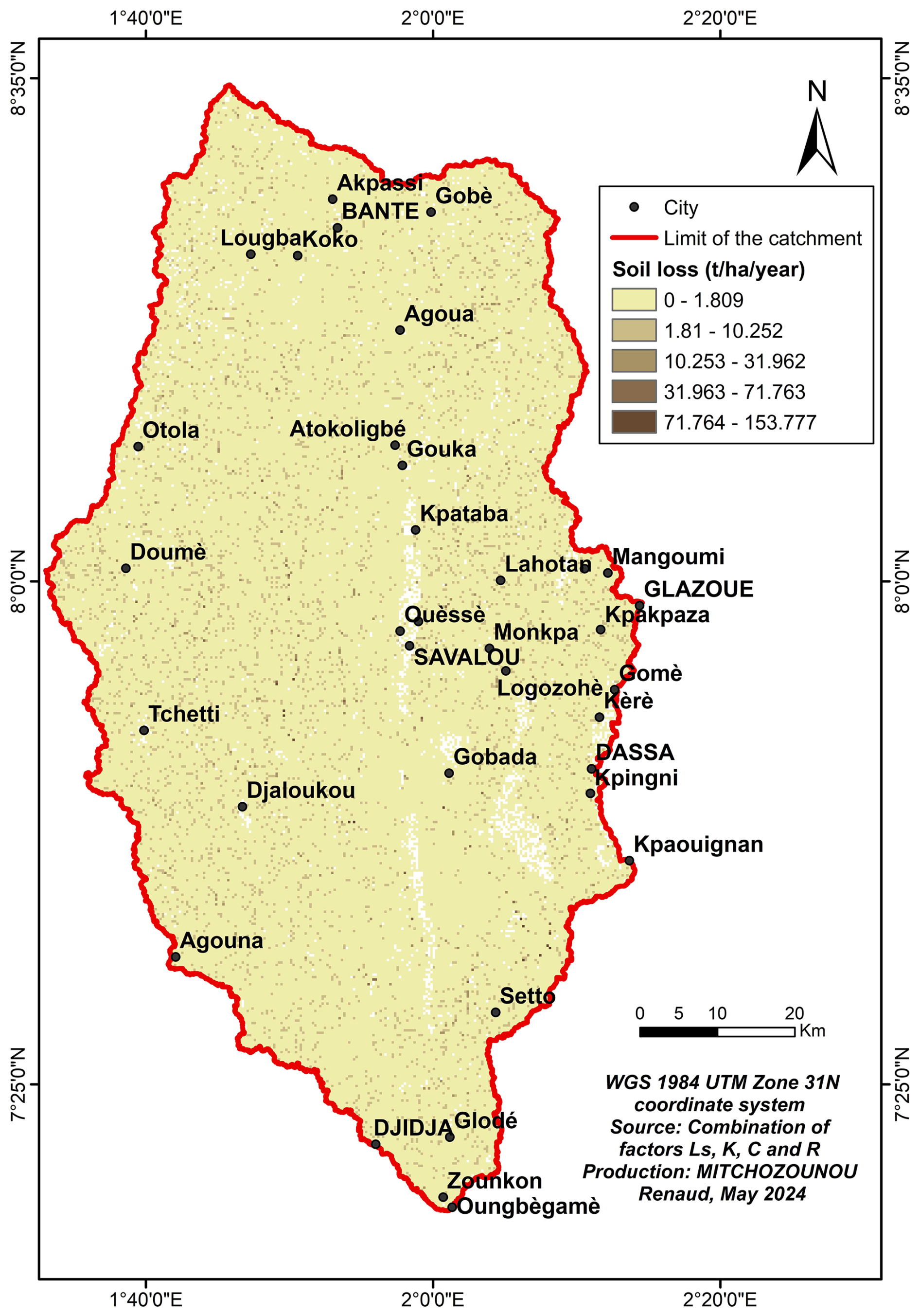
Figure 5Spatial representation of the amount of soil lost.
The areas of soil loss ranging from 71.77 to 153.78 t ha−1 yr−1 represent 0.90 km2 of the catchment area. Indeed, the degradation of vegetation cover (deforestation, farming practices), exacerbated by extreme rainfall and topographical irregularities, promotes water erosion. Soil loss values between 31.97 and 71.76 t ha−1 yr−1 affect an area of 20 km2 of the watershed. These values are observed in areas where the slope is not too steep, combined with vegetation cover that provides some protection and where rainfall is less intense. Soil loss is moderate in areas with gentle slopes where vegetation controls the process, with losses estimated at between 10.26 and 31.96 t ha−1 yr−1. In these areas, soil loss is tolerable. Low (1.82–10.25 t ha−1 yr−1) and very low (0–1.81 t ha−1 yr−1) soil loss values cover 137 and 674 km2 respectively, corresponding to the sedimentation sector.
The spatial pattern of soil loss estimated for the Zou catchment at the Atchérigbé outlet exhibits substantial variability, with most areas experiencing low to moderate annual erosion, while localized hotspots exceed 150 t ha−1 yr−1. These results are consistent with previous RUSLE-based assessments within the broader Zou watershed, where mean annual soil loss was also found to be high and areas of very high erosion risk were identified, particularly on steeper slopes and intensively cultivated lands (Akplo et al., 2020). In the Mékrou watershed of West Africa, USLE applications reported lower average annual soil losses (≈ 3.45–8.50 t ha−1 yr−1) but similarly emphasized significant spatial heterogeneity and elevated erosion in more topographically and climatically vulnerable sub-regions (Attoubounou et al., 2025). Broadscale USLE based mapping across sub-Saharan basins also shows overall mean soil loss rates around 35–75 t ha−1 yr−1, with localized peaks up to 650 t ha−1 yr−1 under highly erodible conditions (Tamene and Le, 2015). In East Africa, studies in Ethiopia's highlands reveal average annual soil loss rates frequently above 35 t ha−1 yr−1, with some catchments exhibiting values exceeding 200 t ha−1 yr−1 on steep cultivated slopes These comparisons suggest that although mean soil loss in the Zou catchment may be somewhat higher than some regional averages, the observed distribution of erosion risk from widespread low/moderate values to discrete high-risk areas is characteristic of tropical and subtropical landscapes where intense rainfall, steep slopes, and anthropogenic land-use changes interact to exacerbate soil degradation. Collectively, these findings reinforce the urgent need for targeted soil and water conservation measures in identified hotspots to mitigate continuing land degradation in central Benin and comparable environments.
Deforestation and wood harvesting exacerbate soil erosion. Analyzing forest cover is therefore essential to understand the main causes of soil degradation in the Zou River basin. The reduction of vegetation cover increases soil vulnerability to rainfall, enhances surface runoff, and leads to the loss of arable land, agricultural degradation, and sedimentation of rivers, thereby disrupting the hydrological cycle (Pimentel et al., 1995).
Remote sensing and GIS have become key tools for mapping erosion and monitoring vegetation cover changes. Landsat imagery is widely used to track land-use dynamics, while the Universal Soil Loss Equation (USLE) remains a reference model for estimating water-induced soil loss (Wischmeier and Smith, 1978b). This model integrates rainfall, topography, vegetation cover, and land management practices. In the Zou basin, the combination of steep slopes and decreasing vegetation cover makes soil erosion particularly critical. Spatial analysis has revealed erosion hotspots, especially on steep slopes and poorly protected soils. As emphasized by Pimentel et al. (1995), such soil losses can reach critical levels, threatening both agricultural fertility and downstream water quality.
This study aimed to identify and map land loss in the Zou watershed at the Atchérigbé outlet using the Universal Soil Loss Equation (USLE) with factors LS, K, C, and R. Results revealed a concentration of eroded land in the western part of the basin, highlighting the critical role of slope in water erosion processes. Vegetation cover, though of moderate influence, confirmed its importance as a protective factor against erosion.
To slow down erosion, it is essential to reduce vegetation loss through reforestation, regeneration of degraded forests, fire control, and regulated grazing. Traditional soil and water conservation practices, combined with awareness campaigns, should also be promoted to ensure the protection of soils and safeguard the livelihoods of future generations.
The satellite imagery (Landsat and DEM) were obtained from USG official site (https://earthexplorer.usgs.gov). The rain data were obtained from Benin Meteo Agency; to have access to the meteorological data, you have to address a request letter to the Meteo Benin direction (https://www.meteobenin.bj/, last access: 16 April 2026). Soil data were obtained from FAO official site (https://www.fao.org/soils-portal/en/, last access: 15 May 2024).
RJETM analyzes statistical data and writes the first draft; TGD analyzes geospatial data and draws maps with RJETM; SVEZ proofreads and the document for corrections; BETI statistics and geospatial analyses and DKFK treat statistical data before them processing.
The contact author has declared that none of the authors has any competing interests.
Publisher's note: Copernicus Publications remains neutral with regard to jurisdictional claims made in the text, published maps, institutional affiliations, or any other geographical representation in this paper. The authors bear the ultimate responsibility for providing appropriate place names. Views expressed in the text are those of the authors and do not necessarily reflect the views of the publisher.
This article is part of the special issue “Circular Economy and Technological Innovations for Resilient Water and Sanitation Systems in Africa II”. It is a result of the 2nd Edition of the C2EA Water and Sanitation Week on “From Research to Innovation and Technology Transfer”, Cotonou, Benin, 3–5 June 2025.
We would like to thank our colleagues for their dedication to their work and for publishing this article.
This paper was edited by Audace Amen V. Dossou-Olory and reviewed by Firmin Adandedji and one anonymous referee.
Akplo, E., Alladassi, K., Houngnandan, P., and Azontondé, A.:Mapping soil erosion risk in the Zou watershed (Benin) using RUSLE integrated with remote sensing and GIS, Modern Journal of Agricultural Sciences, 872–884, https://doi.org/10.1139/cjss-2021-0080, 2020.
Akplo, E., Alladassi, K. K., Houngnandan, P., and Azontondé, A.: Impact of conservation tillage on runoff, soil loss and soil fertility in Acrisols and Ferralsols of Benin, Can. J. Soil Sci., 528–540, https://www.researchgate.net/publication/358652136_Impact_of_conservation_tillage_on_runoff_soil_loss_and_soil_properties_on_acrisols_and_ferralsols_in_central_Benin (last access: 16 April 2026), 2021.
Attoubounou, R. A., Diawara, H., Ludwig, R., and Adounkpe, J.: Quantification of Soil-Water Erosion Using the RUSLE Method in the Mékrou Watershed (Middle Niger River), ISPRS Int. J. Geo-Inf., https://doi.org/10.3390/ijgi14010028, 2025.
Houngnandan, P., Akplo, E., Alladassi, K., and Azontondé, A.: Soil degradation and sustainable land management in Benin, in: Soil and Water Conservation in West Africa, Springer, 215–232, https://link.springer.com/book/10.1007/978-3-032-00704-9?page=2#toc (last access: 16 April 2026), 2019.
Lal, R.: Soil degradation by erosion, Land Degrad. Dev., 12, 519–539, https://doi.org/10.1002/ldr.472, 2001.
Nearing, M. A., Xie, Y., Liu, B., and Ye, Y.: Natural and anthropogenic rates of soil erosion, International Soil and Water Conservation Research, 77–84, https://doi.org/10.1016/j.iswcr.2017.04.001, 2017.
Pimentel, D., Harvey, C., Resosudarmo, P., Sinclair, K., Kurz, D., McNair, M., and Blair, R.: Environmental and economic costs of soil erosion and conservation benefits, Science, 267, 1117–1123, https://doi.org/10.1126/science.267.5201.1117, 1995.
Renard, K. G., Foster, G. R., Weesies, G. A., McCool, D. K., and Yoder, D. C.: Predicting soil erosion by water: A guide to conservation planning with the Revised Universal Soil Loss Equation (RUSLE), USDA Agriculture Handbook 703, ISBN 0-16-048938-5, 1997.
Sadiki, A., Bouhlassa, S., Auajjar, J., Faleh, A., and Macaire, j.: Utilisation d'un SIG pour lévaluation et la cartographie du risque d'érosion par l'équation des pertes en sol dans le Rif oriental (Maroc) cas du Bassin de l'oued Boussouab, Bulletin de l'institut Scientifique, Rabat section Sciences de la Terre, 69–79, https://www.israbat.ac.ma/wp-content/uploads/2015/03/05-%20Sadiki%20et%20al.%20(69-79).pdf (last access: 15 April 2025), 2004.
Tamene, L. and Le, B.: Estimating soil erosion in sub-Saharan Africa based on landscape similarity mapping and using RUSLE, Nutr. Cycl. Agroecosys., https://doi.org/10.1007/s10705-015-9674-9, 2015.
Wachal, D. and Banks, K. E.: Integrating GIS and erosion modeling a tool for watershed management, ESRI international user conference, https://proceedings.esri.com/library/userconf/proc07/papers/papers/pap_1038.pdf (last access: 15 April 2025), 2007.
Wischmeier, H. and Smith, D.: Use and misuse of the universal soil loss equation, J. Soil Water Conserv., 59, 1978a.
Wischmeier, W. and Smith, D.: Predicting rainfall erosion losses. A guide to conservation planning,Édit. US Department of Agriculture, Agriculture Handbook, 537, 1978b.
This study focus on maps soil loss in the Zou catchment in central Benin to help protect farmland. Using satellite images, rainfall records and soil data, we identified areas where soil lost is most at risk. Most of the basin shows low soil loss risk, while small zones on steep slopes are more exposed. The results show the important for better land care and future work with higher-resolution satellite data.
This study focus on maps soil loss in the Zou catchment in central Benin to help protect...