the Creative Commons Attribution 4.0 License.
the Creative Commons Attribution 4.0 License.
 | 19 Apr 2024
Necessary storage for managing early flash flood to save crops in the north-eastern region of Bangladesh
Abdul Wahid Mohamed Rasmy
Flash floods result from the abundant precipitation occurring in the Meghna basin, leading to significant losses of agriculture (specially Boro rice, the only crop of the farmers) in the north-eastern region of Bangladesh. Present practice to save the crop is compartmentalization of depressed area by submersible embankment. After harvesting, water is allowed to enter for fish cultivation with having objective to maintain biodiversity of that area. However, the crop is frequently damaged due to early flash flood before harvesting. Allocating necessary storage to provide spaces for excess water can save the crop. The present study calculates the necessary storage with a new method: Flood duration curve (FDC) to ameliorate floods and estimates water storage capacity of 6 compartments (locally termed as “Haor”) by using satellite-based citizen science haor volume estimation technique. According to the capacity it is observed that early flash flood can be managed by sacrificing crops of one or two haors.
- Article
(4036 KB) - Full-text XML
-
Supplement
(778 KB) - BibTeX
- EndNote


Abundant precipitation in the Meghna basin specially in Meghalaya state of India has remarkable consequences for flash floods in depressed areas (locally termed as “Haor”) of the north-eastern region of Bangladesh. Moreover, as a result of climate change, the more frequent occurrence of intense precipitation may further amplify both the frequency and intensity of flash floods (Masood and Takeuchi, 2016; Masood et al., 2015). This unique climatic characteristics in that area often result in agricultural losses.
In April–June 2022 a devastating flood occurred in this area which caused about 7.2 million people severely affected, 254 251 ha2 of croplands damaged (HCTT, 2022) and estimated total damage at USD 547.6 million (PDNA, 2023). Remarkable characteristics of this flood was its prolonged period due to slower releases of water through the Surma river. After the devastating event, a 9 members' technical committee has been formed by the ministry of water resources to investigate the probable causes of delayed flood release and to recommend feasible solutions. Major two recommendations were (a) Keeping few haors out of crop cultivation and converting them into permanent reservoirs; (b) Identifying some suitable haors where early harvesting rice variety or any other crop can be cultivated and in emergency case these haros can be sacrificed by allowing flood, so that other areas will be saved from risk. In brief, by converting some haors as reservoirs early flash flood can be managed in that area (Masood et al., 2022).
Present practice to save the crop from flash floods is compartmentalization of depressed area by submersible embankment. The height of submersible embankment is designed in such a way that the embankment can protect flood up to harvesting of rice crops (usually up to 15 May). After harvesting, water is allowed to enter in each compartment/haor for fish cultivation with having objective to maintain biodiversity of that area. However, if pre-monsoon comes earlier (before harvesting) these embankments cannot save the crops as water level exceeds design level. In that case, storing the excess water in a reservoir could potentially save the crops as recommended by the technical committee.
This study estimates necessary storage at three stations using Flood duration curve (FDC) method (Takeuchi and Masood, 2017; Masood and Takeuchi, 2015). The study also estimates water storage capacity of 6 haors by using satellite-based citizen science haor volume estimation technique (Ahmad et al., 2020; Khan et al., 2023). Finally, the study investigates the viability of the strategy of deliberately allowing a haor to be inundated as a means of safeguarding other haors.
The downstream of the Meghna basin, in north-eastern Bangladesh is particularly recognized as a flash flood prone region. The Meghna river initiates in Manipur, India, where it is known as the Barak, and upon entering Bangladesh, it splits into two branches. The northern branch, known as Surma, flows northwards along the eastern side of Bangladesh, passing by Sylhet town. This basin encompasses two of the world's wettest places, Mawsynram and Cherrapunji, both situated in Meghalaya state, India, with average annual precipitation of 11 871 and 11 777 mm, respectively (Masood and Takeuchi, 2016). 2458 mm of rainfall was recorded in just three days from 15–17 June 2022 in Cherrapunji which is the highest precipitation in 122 years' history since the rainfall recording has started (PDNA, 2023).
The main crop in this region is Boro rice, a variety cultivated during the dry season in lower lands (Kamruzzaman and Shaw, 2018). The annual production of Boro rice from this area exceeds 3 million metric tons, accounting for approximately 17 % of the country's total production. Notably, Local Boro rice, a native variety, contributes around three-fourths of the total production (Masood and Takeuchi, 2016). Unfortunately, this crop often faces challenges due to flash floods, caused by the influx of river water from the mountainous regions in India.
The key geo-physical characteristic of the area is its lower topography compared to adjacent area; locally which is called “Haor”. In brief, a haor is a wetland ecosystem in the north eastern part of Bangladesh which physically is a bowl or saucer shaped shallow depression. There are 373 haors comprising an area of about 8590 km2 (CEGIS, 2012). However, up to June 2022 about 99 haors are protected by about 2728 km length submersible embankment which are constructed by Bangladesh Water Development Board (BWDB) with the assistance of government of Bangladesh and foreign aided fund (BWDB, 2022).
Observed river water level (daily) and discharge data (weekly) from 1980 to 2022 at three stations of Surma river, Kanairgat_SW266, Sylhet_SW267 and Sunamganj_SW269 were collected from the Hydrology Division, BWDB. For better result, here, daily water level data was used to draw FDC and the available discharge and corresponding water level was used to establish the stage-discharge relationship (H-Q rating equation) in each station.
First, the FDC was potted from observed water level to estimate necessary storage.
4.1 Plotting of FDC
FDC presents the extreme values of moving averages of discharge over m-period (days) estimated from the observed time series. In this study, m was varied from 1 to 365 d. Generalized extreme value (GEV) distribution has been applied on this series to estimate extreme values for 5, 10, 20 and 50-years return periods. Detail procedure of plotting FDC with mathematical expression is presented by Masood and Takeuchi (2015).
In general, duration curves are drawn with considering annual maxima (maximum in monsoon period) from daily discharge data. However, in this study duration curves are drawn (a) with water level data instead of discharge data because of the availability of daily water level data and (b) with considering pre-monsoonal maxima (maximum in pre-monsoon period; March–May) series instead of annual maxima series as the main focus of this study is to alleviate pre-monsoonal early flash flood.
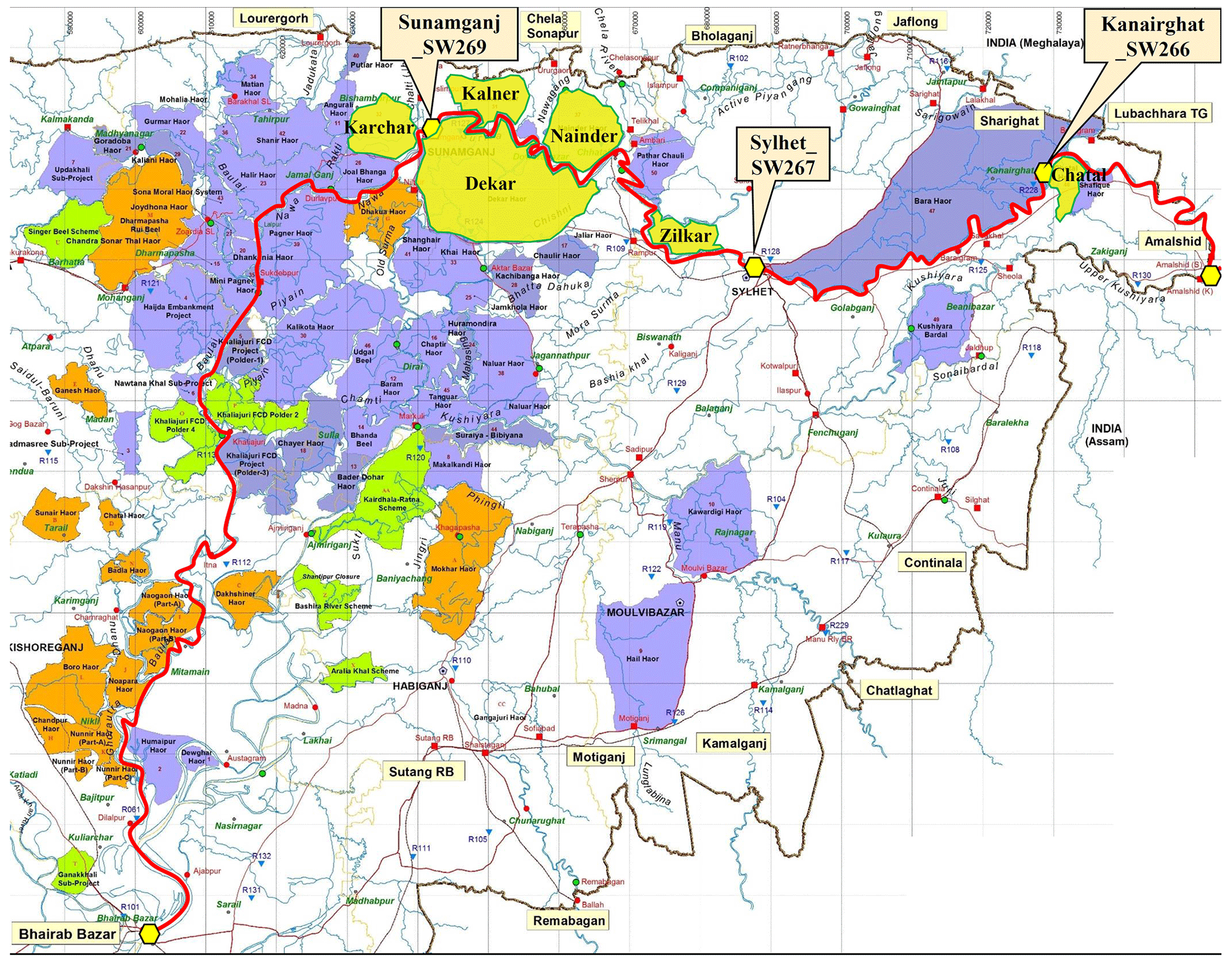
Figure 1Haor map of north-eastern region of Bangladesh. The study haors are yellow marked.
4.2 Estimation of necessary storage
The necessary storage indicates the volume of water necessary to store somewhere for flood control at the beginning of flood season. This storage can be calculated from FDC as illustrated by Takeuchi and Masood (2017). In short, the necessary storage is obtained from the largest inner rectangular area that just fits to the area surrounded by a duration curve, the target discharge level and the vertical axis at the origin. Rectangular area under FDC is expressed as volume of water [L3] which is multiplication of x-axis; m [T] and y-axis; discharge [L3 T−1]. In our study, to draw FDC we choose water level instead of discharge. Therefore, to get storage volume we had to estimate discharge from corresponding water level, which is calculated from H-Q rating equation of each gauge station. And, in our case, the submersible embankment crest level is chosen as the target level. Because, when river water level exceeds that level water overtops the embankment and causes flood in haor area.
4.3 Estimation of reservoir volume of haors
Satellite-based citizen science haor volume estimation technique has been used to estimate reservoir volume of haors. The technique is developed by the University of Washington SASWE Research Group under NASA-supported project led by University of North Carolina. With the technique, volumetric storage for 6 haors is calculated by employing extensive remote sensing data, which included information on water surface extent and elevation. Additionally, citizen-contributed gauge data was incorporated into the analysis. A trapezoidal bathymetry was assumed, and an area-volume relationship was established for specific haors. This relationship was then applied to extrapolate volumetric estimates across all haors in the region. The detail methodology is described by Ahmad et al. (2020).
5.1 Hydrologic characteristics
Using the 42-year (1980–2022) daily water level data for three stations Fig. 2 plots (a) box-and-whisker plot depicting the range of variability for each month, (b) pre-monsoonal daily water levels of historical floods in 1998, 2007, 2017 and 2022. The major observations from the figure are as follows:
-
In the boxplots for all stations it is observed that variation of water level is high in April–May compared to that of other months. This higher variability of water level is due to higher variability in rainfall pattern in those months. In pre-monsoon season often high precipitation occur in Meghalaya region of India which cause early flash flood in haor area.
-
It is also observed in the boxplots that number of outlier in February–April is higher than that of in other months. Outliers is often regarded as the presence of extreme values which may underestimate or overestimate a study because it lies at an abnormal distance from other values in a random sample from a population. These outliers in higher ranges represents very high extreme water level due to flash floods resulting from high precipitation in upstream.
-
Pre-monsoonal daily water levels show how water rises suddenly in late-March to mid-April. In particular, during the devastating flood of 2017, water overtopped almost all embankments, resulting in the loss of all crops for that season. It is also observed that water levels are significantly higher than pre-monsoonal monthly mean of all stations.
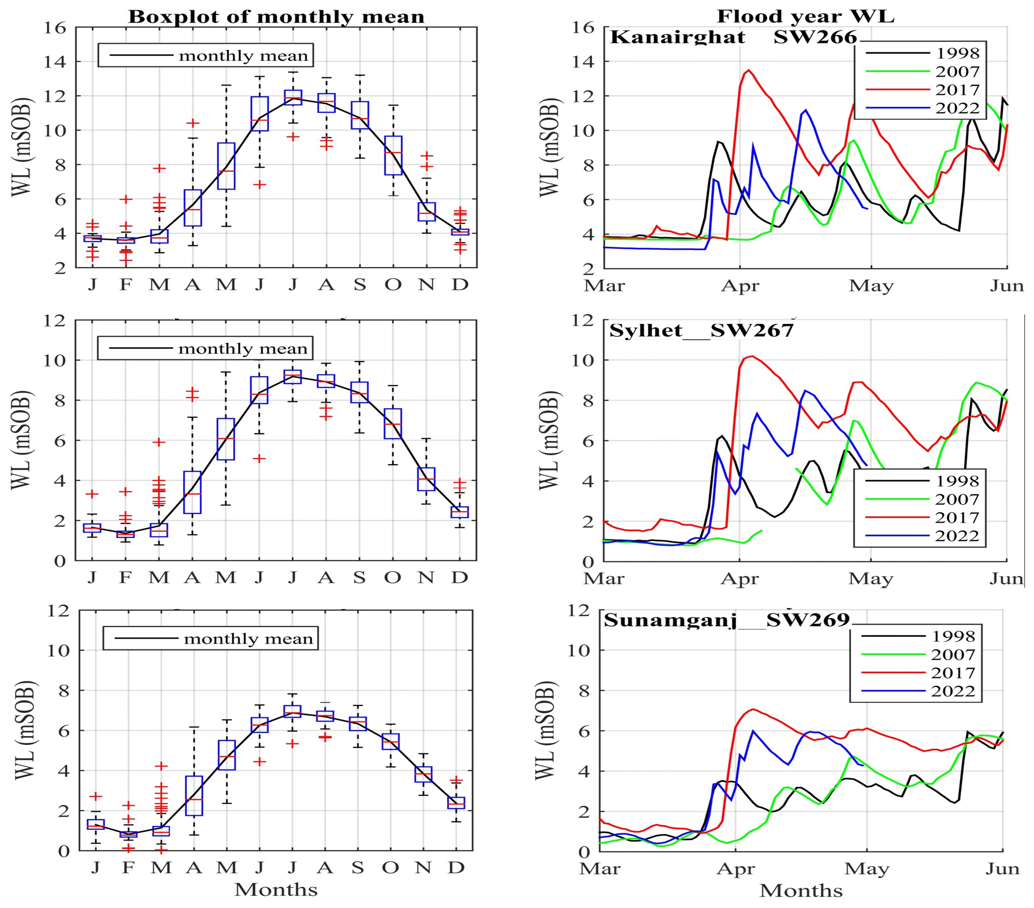
Figure 2Box-and-whisker plot of monthly mean and pre-monsoonal daily water levels of historical floods.
5.2 Necessary storage
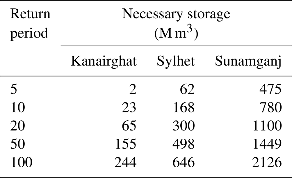
FDCs of three stations for 5, 10, 20, and 50-year return period have been plotted in Fig. 3. Largest rectangle within the FDC and above the thick line shown as dotted line in the figure. Area of the rectangle represents volume of storage needed to manage flood. The estimated necessary storages at three stations for different return period are listed in the Table 1. It is observed that necessary storage increases with the increase of return period. This is attributed to the elevated magnitude of floods associated with longer return periods. Consequently, a greater storage is essential for effectively managing floods of higher magnitudes. It is also observed that necessary storage at Sunamganj station is higher than that of other two stations. For example, necessary storage at Sunamganj is 1100 M m3 while that at Kanairghat and Sylhet is 65 and 300 M m3, respectively for 20-year return period. It is obvious that higher storage is necessary at downstream than that at upstream to manage flood as accumulated discharge increases towards downstream.
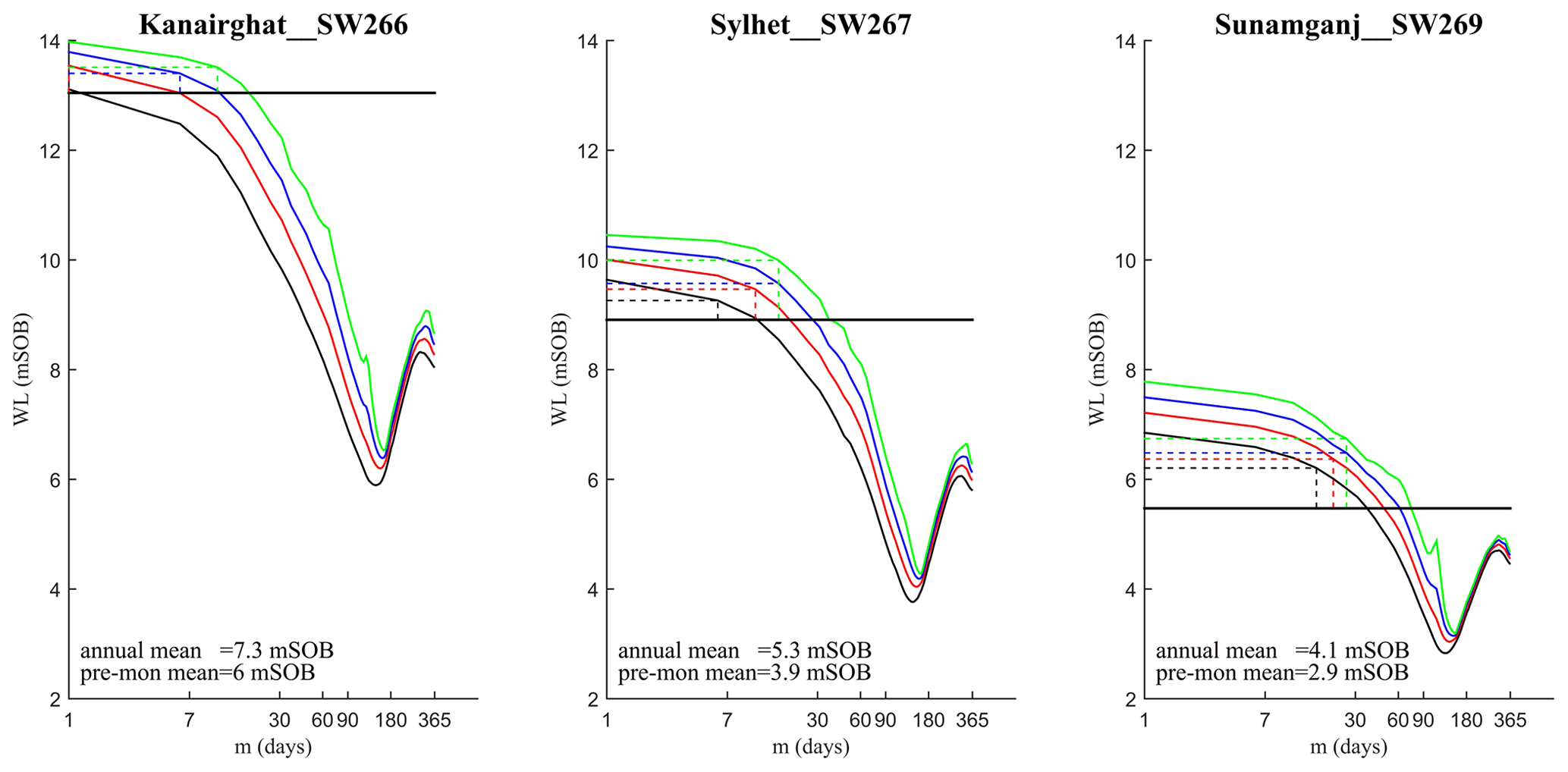
Figure 3FDCs for three stations for 5 (black), 10 (red), 20 (blue), 50 (green)-year return period (thick line indicates embankment crest level). [SOB = Survey of Bangladesh].
Table 1Necessary Storage of three stations for different return period.
5.3 Water storage capacity of haors
The selection of 6 haors took into account the following factors: (a) adjacent to the Surma River to facilitate a quicker impact on flood with rapid water release, and (b) size of haor ranging from smaller to larger.
Reservoir volume of these haors have been calculated by the technique described in Sect. 4.3 and listed in Table 2. Figure 4 shows time series (from January 2017 to October 2022) of volume of water stored in Kalner haor which is located just upstream of Sunamganj station. It shows that water stored in the haor is nearly zero during the dry and pre-monsoon season. Because, at that time the haor is bounded by embankment to protect crops. After harvesting (usually after 15 May) water is overtopped the embankment and haor is submerged quickly. In general, haor reaches its highest capacity in monsoon (June–July). Maximum volume of water stored in Kalner haor is about 172 M m3. However, at water level near the crest level of submersible embankment (end of May) volume of water stored in Kalner haor is near about 100 M m3. Time series plots of water storage capacity of these haors are presented in the Supplement.


5.4 Early flash flood management by sacrificing any haor
The necessary storage denotes the volume of water that needs to be stored at upstream at the onset of the flood season for the purpose of flood control at a specific location. Therefore, it also indicates the relative difficulty or ease of flood management. In our study area, there is insufficient space to store excess water during floods unless a haor is deliberately allowed to be inundated. Thus, opting to sacrifice the crops in one haor may be a viable solution to protect the crops in other haors.
From Table 1, it is observed that management of early flash flood at Kanairghat and Sylhet is relatively easier than that at Sunamganj as necessary storages are lower. The flood of those area can be relieved by sacrificing crops (i.e by allowing to be submerged) of one or two medium sized haors. However, for flash flood management at Sunamganj (necessary storage is 1100 M m3 considering flood of 20-year return period), two large haors (like Dekar haor whose water storage capacity is 512 M m3) need to be sacrificed.
This is an alternative solution for early flash flood management. However, if such a scenario is necessary, the government must provide compensation to farmers for their crop losses; otherwise, it could lead to a social crisis and conflicts among farmers.
This study presents an innovative methodology to estimate necessary storage for early flash flood management by FDC using long-term time series of water level data at three stations. It also calculates water storage capacity of 6 haors using satellite-based citizen science haor volume estimation technique. According to the capacity it is observed that early flash flood can be managed by sacrificing crops of one or two haors. Nevertheless, in order to prevent social conflicts and adequately compensate farmers for their losses, the government should implement necessary measures.
The study still has some limitations which can be addressed in future studies. For example, the uncertainty in estimating the storage, linked to the frequency distribution method, H-Q rating equation and availability of satellite data, requires attention. In this study, the investigation into an alternative approach for early flash flood management focuses solely on six haors. Including a larger number of haors in the analyses can enhance the comprehensiveness of the study, providing a more thorough understanding and presenting improved alternatives for selecting a viable solution.
The python code to estimate reservoir volume of haor from remote sensing data is available from Khan et al. (2023).
The data that support the findings of this study are available from the corresponding author ([Muhammad Masood) upon reasonable request.
The supplement related to this article is available online at: https://doi.org/10.5194/piahs-386-27-2024-supplement.
The authors' contributions to the paper are as follows: Conceptualization, Data curation, Methodology, Formal analysis – MM; Supervision and Validation – AWMR; Writing – original draft preparation – MM. Both authors critically reviewed the results and have approved the final version of the manuscript.
At least one of the (co-)authors is a guest member of the editorial board of Proceedings of IAHS for the special issue “ICFM9 – River Basin Disaster Resilience and Sustainability by All”. The peer-review process was guided by an independent editor, and the authors also have no other competing interests to declare.
Publisher's note: Copernicus Publications remains neutral with regard to jurisdictional claims made in the text, published maps, institutional affiliations, or any other geographical representation in this paper. While Copernicus Publications makes every effort to include appropriate place names, the final responsibility lies with the authors.
This article is part of the special issue “ICFM9 – River Basin Disaster Resilience and Sustainability by All”. It is a result of The 9th International Conference on Flood Management, Tsukuba, Japan, 18–22 February 2023.
The authors express their gratitude to Faisal Hossain and Shahzaib Khan from the University of Washington, USA, for providing the code used to estimate the reservoir volume. The first author acknowledges the support extended by The International Centre for Water Hazard and Risk Management under the auspices of UNESCO (ICHARM) for attending ICFM9. Special thanks are given to ICFM9 for covering the publication charges.
This paper was edited by Svenja Fischer and reviewed by Yukiko Hirabayashi and one anonymous referee.
Ahmad, S. K., Hossain, F., Pavelsky, T., Parkins, G. M., Yelton, S., Rodgers, M., Little, S., Haldar, D., Ghafoor, S., Khan, R. H., Shawn, N. A., Haque, A., and Biswas, R. K.: Understanding volumetric water storage in monsoonal wetlands of northeastern Bangladesh, Water Resour. Res., 56, https://doi.org/10.1029/2020WR027989, 2020.
BWDB: Annual Report 2021–22, Bangladesh Water Development Board, Dhaka, Bangladesh, 120 pp., 2022.
CEGIS: Master Plan of Haor Area, Summary Report, 1, Bangladesh Haor and Wetland Development Board, 2012.
HCTT: Flash Flood 2022 Humanitarian Response Plan, UN Bangladesh Coordinated Appeal, Humanitarian Coordination Task Team, 28 pp., 2022.
Kamruzzaman, M. and Shaw, R.: Flood and sustainable agriculture in the Haor Basin of Bangladesh: A review paper, Universal J. Agr. Res., 6, 40–49, https://doi.org/10.13189/ujar.2018.060106, 2018.
Khan, S., Hossain, F., Pavelsky, T., Parkins, G. M., Lane, M. R., Gomez, A. M., Minocha, S., Das, P., Ghafoor, S., Bhuyan, M. A., Haque, M. N., Sarker, P. K., Borua, P. P., Cretaux, J., Picot, N., Balakrishnan, V., Ahmad, S., Thapa, N., Bhattarai, R., Hasan, F., Fatima, B., Ashraf, M., Ahmad, S. K., and Compin, A.: Understanding Volume Estimation Uncertainty of Lakes and Wetlands Using Satellites and Citizen Science, IEEE J. STARS, 16, 2386–2401, https://doi.org/10.1109/JSTARS.2023.3250354, 2023.
Masood, M. and Takeuchi, K.: Climate Change Impact on the Manageability of Floods and Droughts of the Ganges-Brahmaputra-Meghna Basins Using FDCs and DDCs, J. Disaster Res., 5, 991–1000, https://doi.org/10.20965/jdr.2015.p0991, 2015.
Masood, M. and Takeuchi, K.: Climate change impacts and its implications on future water resource management in the Meghna Basin, Futures, 78, 1–18, https://doi.org/10.1016/j.futures.2016.03.001, 2016.
Masood, M., Yeh, P. J.-F., Hanasaki, N., and Takeuchi, K.: Model study of the impacts of future climate change on the hydrology of Ganges–Brahmaputra–Meghna basin, Hydrol. Earth Syst. Sci., 19, 747–770, https://doi.org/10.5194/hess-19-747-2015, 2015.
Masood, M., Ullah, M. E., and Das, S. C.: Causes of Early Flash-Flood in Haors of Bangladesh and Recommendations for Flood Management to Save Crops and to Maintain Biodiversity, IPWE-2023, Dhaka, 4–6 January 2023, ISBN 978-984-35-3438-5, 2022.
PDNA: Post Disaster Needs Assessment Bangladesh: Floods 2022, Ministry of Disaster Management and Relief, GoB, 50 pp., 2023.
Takeuchi, K. and Masood, M.: Necessary storage as a signature of discharge variability: towards global maps, Hydrol. Earth Syst. Sci., 21, 4495–4516, https://doi.org/10.5194/hess-21-4495-2017, 2017.