Articles | Volume 386
https://doi.org/10.5194/piahs-386-1-2024
Post-conference publication
 | 
19 Apr 2024
Post-conference publication |  | 19 Apr 2024

Controlling Sedimentation through Regulating the River by Thalpitigala Reservoir Project

Thanura Lasantha Babarande Guruge, Bandara Palugaswewa, and Shinji Egashira
Abstract

Mahaweli is the main river in Sri Lanka and it has many main multipurpose reservoirs, especially to cater power and irrigation requirement of the country. Reservoir capacity loss which is the major problems causing to the effectiveness of the major reservoirs in Sri Lanka, is mainly caused by sedimentation due to upstream erosion.

Hence proper monitoring, calculating and adopting measures are very important in planning a reservoir. But due to the complex nature of factors effect on sedimentation and lack of long-term data make calculation difficult.

This study discusses how different data obtained from numerical modelling and bathymetric surveys of different locations of the catchment and those are used to select and verify the empirical equation, calculation of capacity loss and make proposals to minimise sedimentation for proposed Thalpitigala Multipurpose Project in Mahaweli upper catchment.

The outcomes indicate high erosion (690 m3 km−2) and sediment transportation making rapid loosing of the capacity (5.13 MCM in 15 years) of the proposed reservoir. Thus, upper catchment protection with reforestation to reduce erosion, introduction of check dams in the upstream flow to trap the transported sediment and introduction of proper removal measures of deposited sediment are discussed for the proposed reservoir project.

1 Introduction

Sediment load is one of the most important parameters required for the selection of the dam type, the estimation of dead storage and for the design of proper sediment flushing facilities.

Among the catchments in Sri Lanka, the highest sediment yield has been reported from the Uma Oya catchment by a study done in 2019 (Dias, 2019). It is shown that erosion is 3 to 130 times faster than the soil loss tolerance (5 t ha−1 annum−1) in Sri Lanka.

Uma Oya catchment (between 6°4523′′ N, 81°0308′′ E and 6°5929′′ N, 81°0058′′ E), a sub basin of Mahaweli river basin is located in the South-Eastern slopes of the central hills of Sri Lanka with an area of 720 km2 (Fig. 1)

The last reservoir about to construct in this catchment is Thalpitigala which is considered as a multipurpose reservoir project.

Figure 2 shows the Uma Oya catchment (720 km2) and locations of proposed reservoir- Thapitigala, and other considered points.

The upstream reservoirs of the catchment, Puhulpola reservoir (Catchment area 180 km2) and Dyaraba reservoir (Catchment area 158 km2), may not cut down in full the suspended solids passing to the Thalpitigala reservoir, since those reservoirs have bottom outlets to flush the sediments, hence it is a commendable to consider nearly 80 % of the catchment sediments are to be come into the proposed reservoir.

In contrast, Thalpitigala reservoir can't eject trapped sediments at once to the river downstream as there are set of reservoirs in Mahaweli system. Consequently, it is obvious that the sediment management in the proposed reservoir is a key design factor to maintain the wellbeing and the effectiveness of the reservoir in the future.

In Figs. 3 and 4, the arial photos in rainy and dry seasons in the proposed reservoir stretch.

https://piahs.copernicus.org/articles/386/1/2024/piahs-386-1-2024-f01

Figure 1Mahaweli River Basin and Uma Oya Sub Basin.

https://piahs.copernicus.org/articles/386/1/2024/piahs-386-1-2024-f02

Figure 2Area Map of Uma Oya Catchment.

https://piahs.copernicus.org/articles/386/1/2024/piahs-386-1-2024-f03

Figure 3Arial photo of Uma Oya in rainy season (©Google Earth).

https://piahs.copernicus.org/articles/386/1/2024/piahs-386-1-2024-f04

Figure 4Arial photo of Uma Oya in dry season (©Google Earth).

https://piahs.copernicus.org/articles/386/1/2024/piahs-386-1-2024-f05

Figure 5Photo of Run off of upper catchment of Uma Oya-Dayaraba Dam.

Download

The magnitude of sediment transportation in the water can be evidently seen by comparing the dry and flood flows shown in following Figs. 3 and 4. The spill water characteristic of upstream Dayraba reservoir in rainy seasons is shown in Fig. 5.

2 Characteristics of sediment yield in study basin

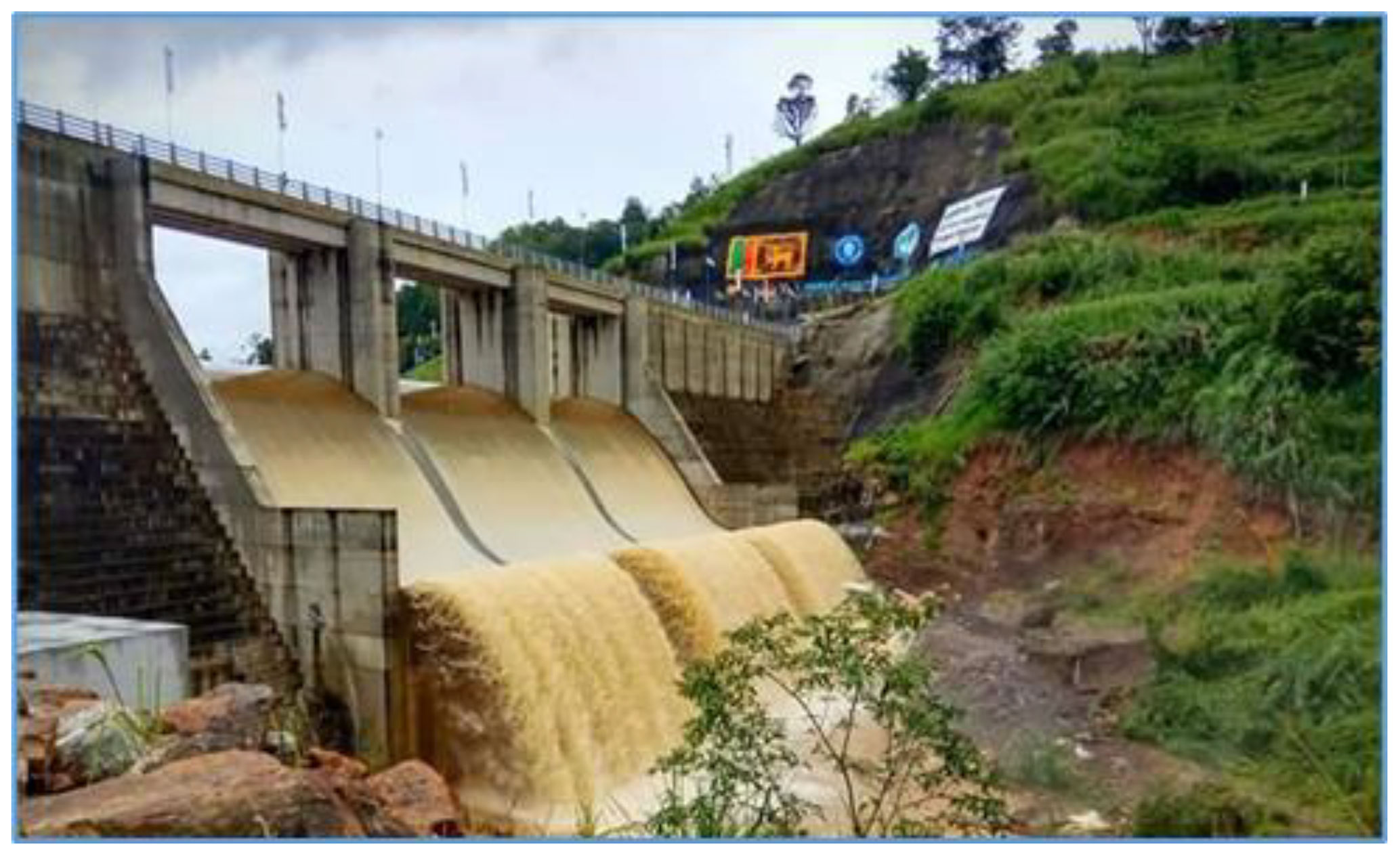
The sediment quantity transported with the upstream flows deposited and travelled in a reduced rate in the reservoir system governing the distance by the decreased water velocity, making complex analyses in sediment studies.

In the study of the erosion rates in the catchment, the land cover properties, land use properties, geography, soil parameters etc. have to be considered.

When we have to study the sediment inflow, settling, and degradation courses relation with known factors such as water velocity, particle size, particle type, turbidity, cross flows etc. The difficulty of analysing the Sedimentation processes in a reservoir can be reduced by truncating minor factors and considering most influencing factors,

Because of this complexity, many mathematical models and empirical relationships are being developed to simulate the physical processes of sediment transport and deposition in reservoirs.

The results of modelling and simulations can be verified by bathymetric measurements of sediment loads in known points and volumetric measurements of partials in runoff water. Those can be spatially and temporally analysed to understand the variation of sediment transportation throughout the river flow.

Herewith we are going to discuss some empirical measurements and simulations used to determine the reservoir sedimentation, life reduction and measures intended to implement to minimize the vulnerability.

The following calculations show three different methods used in three different occasions, for three different locations of the same catchment.

2.1 Calculation of Sediment Delivery Ratio and Sediment Yield

The sediment delivery ratio (SDR) of a river basin reflects the conveyance status of sediment which occurs due to erosion of soil, through runoff of the stream flow. The sediment delivery ratio calculation models have certain related conditions such as environmental factors, rainfall, land topography, soil type and texture etc. The drainage basin area method (Vanoni, 1975) is used to determine SDR considering the similarities of above factors to model catchment.

SDR=0.42A-0.125

Total catchment area of Uma Oya at the confluence of Mahaweli (Upstream of Ranteme reservoir) is 720 km2; Catchment Area = 281.25 sq. miles; Therefore SDR = 0.21

SDR=SedimentyieldGrossErosion

Universal soil loss equation

A=R×K×LS×C×P

Erosiverainfallforces(R)=120Inherenterodibilityofthesoil(K)=0.67Hillsidelength-slopefactor(LS)=1.91Landcoverfactors(C)=0.5LandUsefactors(P)=0.75Longtermsoillossrate(A)=57.59tAcre-1annum-1Soilgrosserosion=144.00tha-1annum-1Annualsedimentyield=30.0tha-1annum-1AnnualSedimentYield=11.28m3haannum-1AnnualSedimentYield=1128m3km-2annum-1

2.2 Annual Sedimentation for Proposed Reservoir Location.

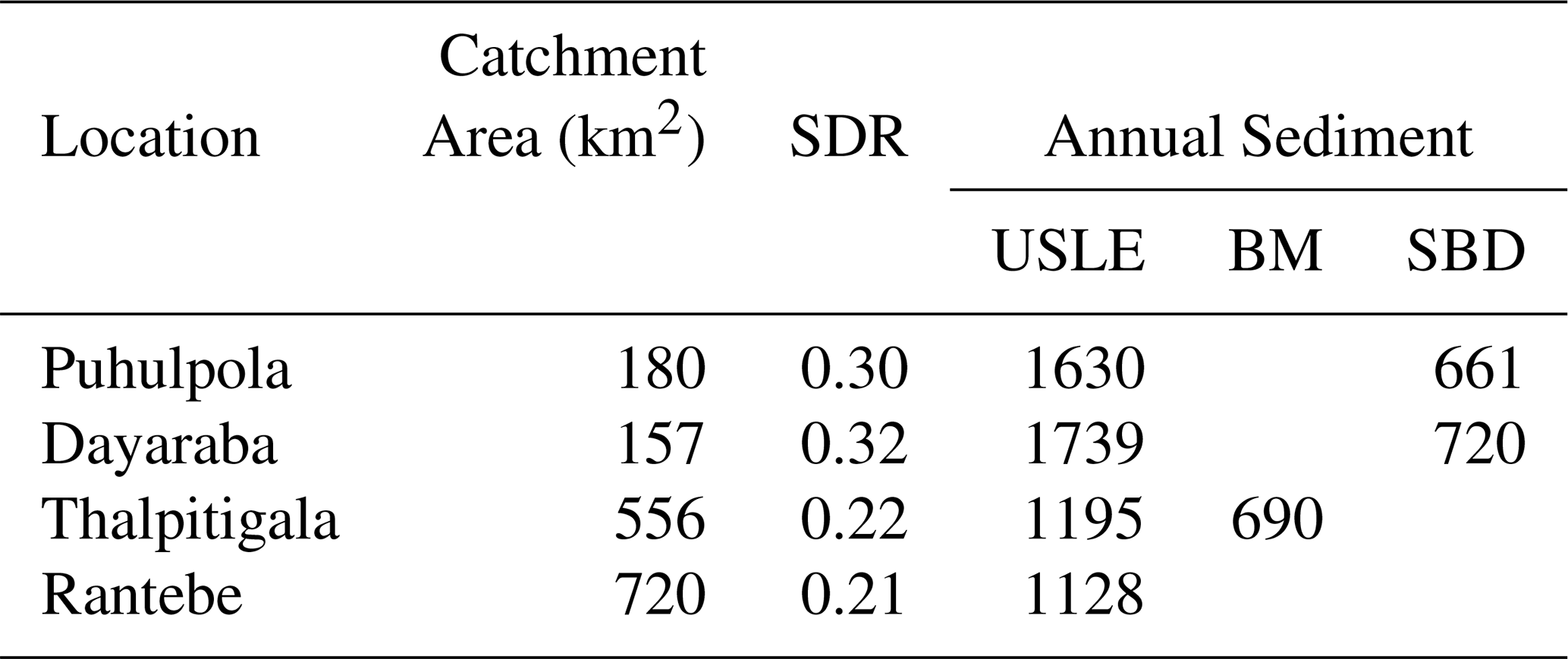
As per the sediment analyses done by Ministry of Irrigation, the following results have been obtained in feasibility report. The analyses have been done through bathymetric mapping done for downstream of Uma Oya for a catchment area of 556 km2 at Bathmedilla weir section (SDR = 0.22) in 2013.

Annualsedimentyield=18.30tha-1annum-1Annualsedimentyield=690m3km2annum-1

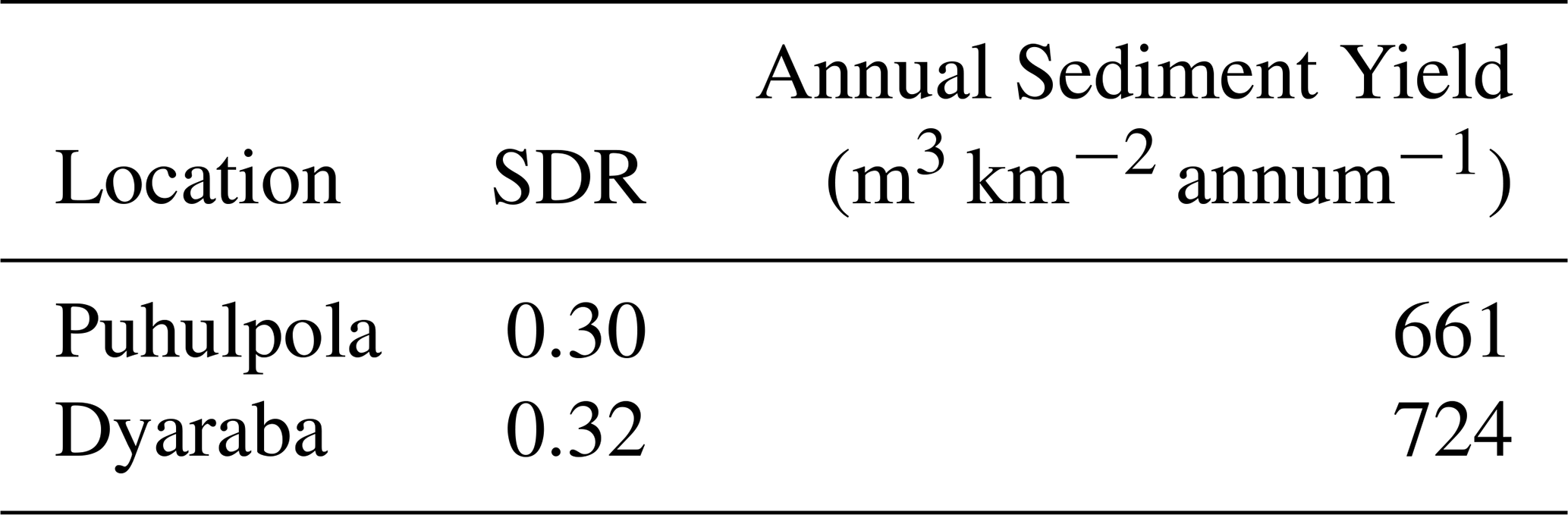
2.3 Annual sedimentations at Puhulpola and Dayaraba Reservoirs

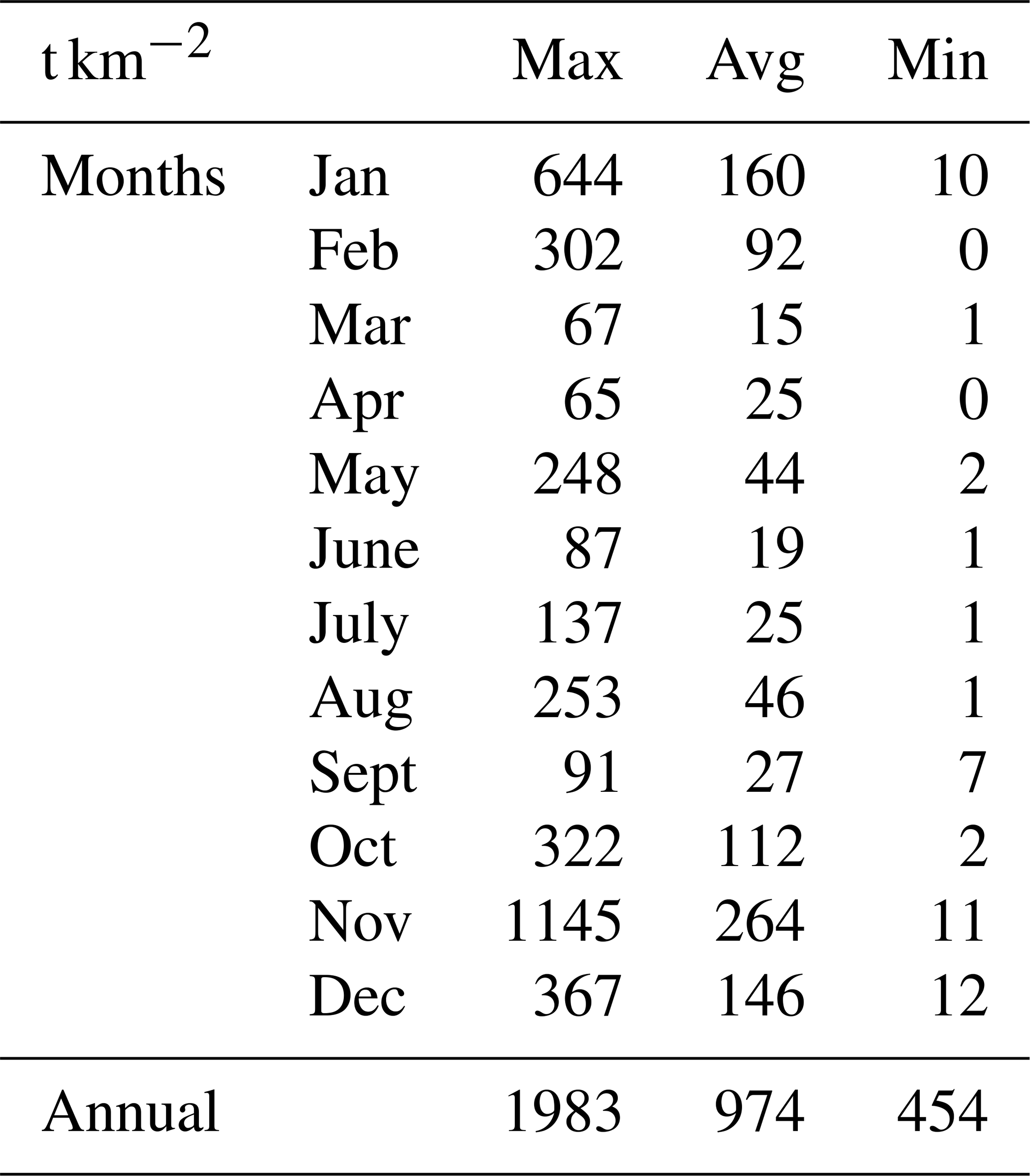
The study done by Ministry of Irrigation and Farab in 2010 in above reservoirs in the upstream of Uma Oya using EPM method and sediment sampling data for 8 years, shows the results as follows.

This is a very comprehensive study which has considered most of the complex parameters in simulation of mathematical model. Table 1 shows the summary of compiled data of 8 years

Table 1Specific sediment yield at Welimada Station.

Download Print Version | Download XLSX

Table 2 shows the results obtained for upper catchment reservoirs from simulation of sediment bulk density.

Table 2Results of sediment yield in Uma Oya catchment.

Download Print Version | Download XLSX

https://piahs.copernicus.org/articles/386/1/2024/piahs-386-1-2024-f06

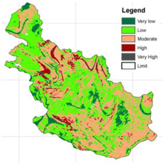
Figure 6Erosion rate in Uma Oya basin.

Figure 6 shows the variation of erosion rate in Uma Oya basin according to the simulation done using EPM model.

Table 3Comparison of results with calculated results using universal soil loss equation.

USLE – Universal soil loss equation. BM – Bathymetric Mapping. SBD – Simulation of Sediment Bulk Density.

Download Print Version | Download XLSX

Herewith, as indicated in Table 3 the practical results obtained from BM and SBD are considered for further analyses as USLE shows fairly high values than experienced.

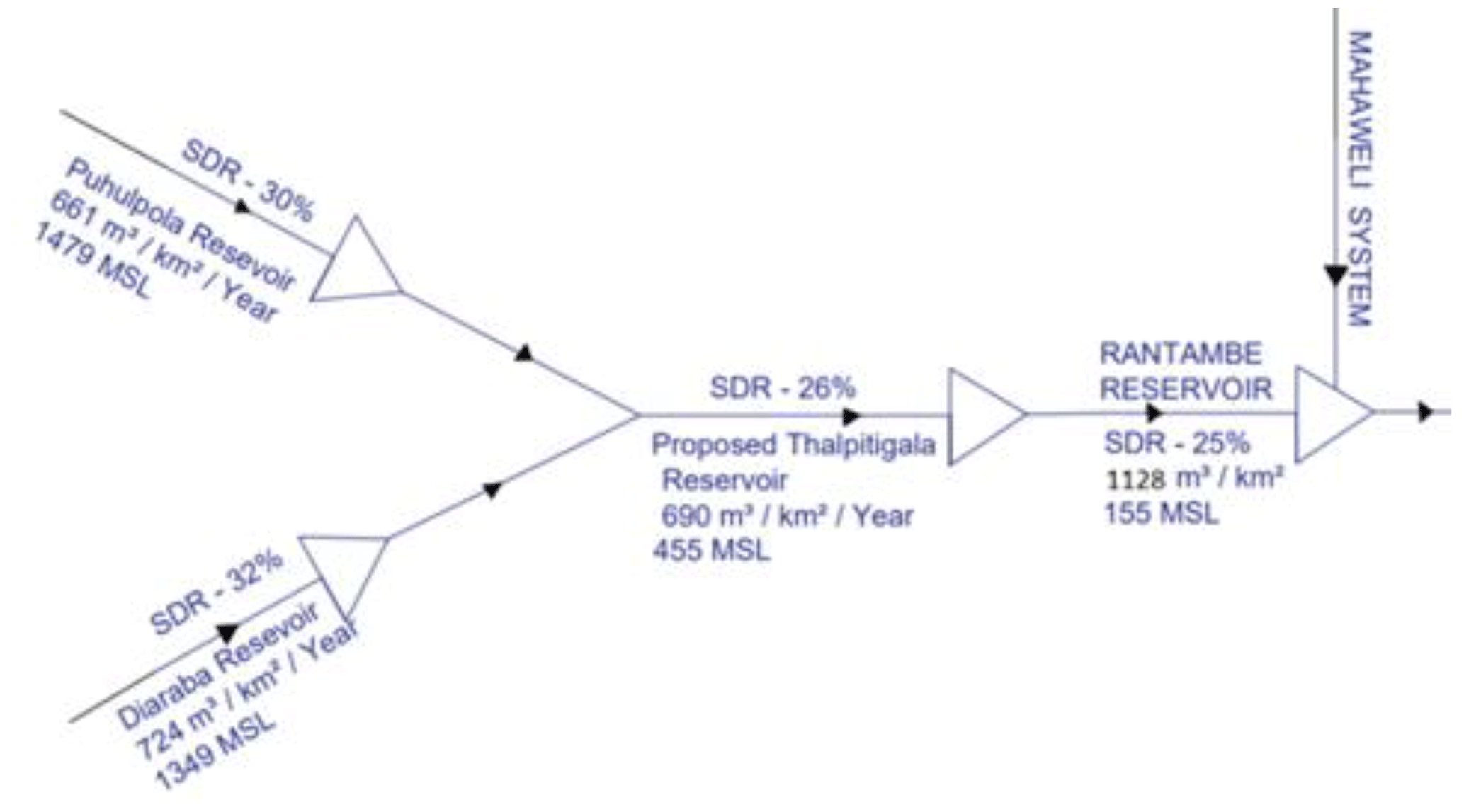
Accordingly, the specific sediment yield in each location can be showed in following Fig. 7.

https://piahs.copernicus.org/articles/386/1/2024/piahs-386-1-2024-f07

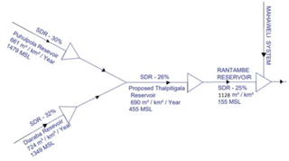
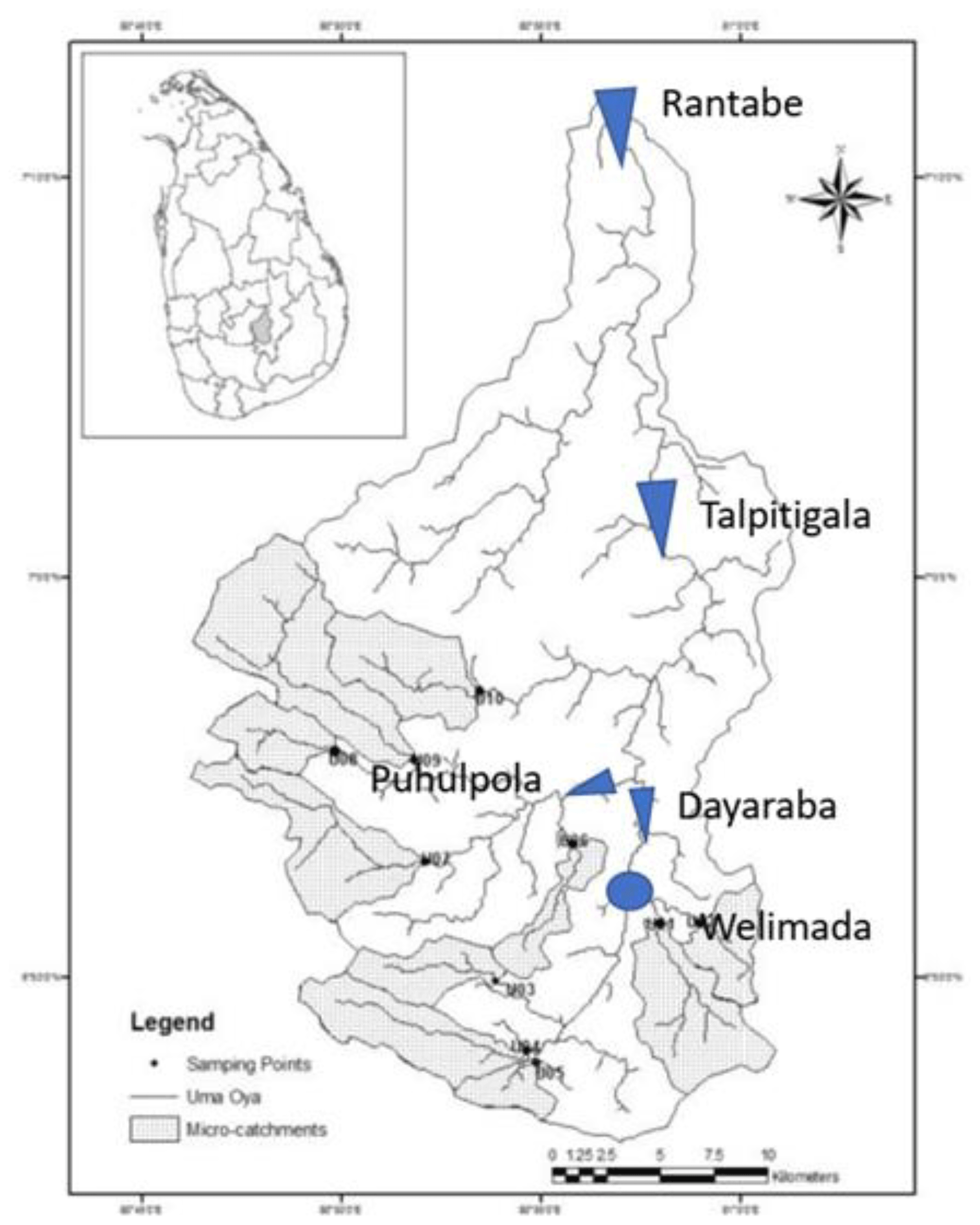
Figure 7Schematic diagram of Reservoir system in Uma Oya.

Download

Considering the annual sediment yield to proposed Thalpitigala Reservoir, the deposition was projected.

InitialReservoircapacity=15.56MCMProjectLifetime=50yearsTrapEfficiencyAssumepercentagefilledwithtyears;0.43%FirstC/T=0.066FirstTrapEfficiency=82%FinalC/T=0.037FinalTrapEfficiency=73%AverageTE=77.5%Timeperiod=14.4yearsSedimentyield=5.13MCM

Accordingly, within one third of life time, the reservoir losses one third of its capacity which implies the total dead storage vanishes. Hence sediment management is very essential

3 Sediment Control and Management Methods

In controlling and managing the sedimentation, it is needed to outline an allowable sediment discharge from the point we consider, to the downstream. Then the sediment volume should be controlled at the considered point.

In order to reduce reservoir sedimentation, we may have two possible methods: One is to reduce the inflow rate of sediment to the reservoir, and the other is to reduce sedimentation within the reservoir.

https://piahs.copernicus.org/articles/386/1/2024/piahs-386-1-2024-f08

Figure 8Closed type check dam.

Download

The prior methods implicate various erosion controls by means of structural and non-structural measures by using check dams, soil conservation performances, etc. The latter is to reduce the sediment deposition within the reservoir by means of dam operations such as sediment flushing, sediment sluicing, sediment bypassing, etc. Figure 8 illustrates a sample of the check dam to reduce sediment erosion.

4 Conclusion and Recommendations

Among the said measures, for this project the following measures are considered.

  • Reduce sediment yield from upstream – Introduce check dams to capture sediments

  • Introduce upper catchmant management to reduce erosion. – Reforestration

  • Route Sediments/Remove sediments – Introduce two bottom outlets to the dam flush through separate channel to adjacent basin- Wela Oya which do not have reservoirs in down stream

4.1 Check dams

In this regard our main intention is to trap sediments. Accordingly, 50 % of sediment specially the bead load is intended to be trapped and removed by dredging. Therefore, the closed type check dams (about 3 in selected locations) are recommended. The collected or dredged sediments can be used for other purposes such as construction sand from course material and fertilizer by fine organic layer after drying. Those options should be checked and verified with annual collected sediments volume, and verify the feasibility.

4.2 Bottom outlets

Two bottom outlets are suggested for the dam, from each side of the spillway. The sediment flushing is suggested while the reservoir water level is at low levels in order to increase the efficiency if sediments removing. As mention early when the sediment flushing is in operation the sediments could be mixed and disturbed via mechanical methods in order to increase the sediment outflow. Then the trapped or deposited sediments also could be deposited and removed. However frequent and timely flushing can reduce the requirement for mechanical mixing. Those should be carefully mentioned in operation manuals.

In a flushing process, mainly the finer particles are extracted. However, the flushed sediment can't be allowed to transport in the same basin further downstream river flow since there are some important reservoirs in Mahaweli system. Therefore, the flushed bed load could be trapped just downstream of the dam with a structure such as sedimentation tank, small check dam type walls or cascade, etc. The collected sediments could be removed and used as suggested in check dams.

The suspended sediment can be transported with the flush water to the adjacent catchment Wela Oya which doesn't have any reservoir in its downstream.

When these structures are designed, design Sediment discharges, flood volumes and levels, required sediment removing frequency, the access and machineries to be used, etc. should be thoroughly examined and analysed in crucial locations.

The monitoring of sediment is very important even after the construction of structures. Hence periodical bathymetric mapping in the reservoir and check dams are essential for timely removals of sediment. The volumetric measurement of sediment yield in identified control points in daily basis is required for integrated sediment management of total reservoir system.

4.3 Upper Catchment Protection Measures

The most sustainable sedimentation control measure among all is the upper catchment development to minimize the erosion. Accordingly, reforestation in steep slopes of the catchment is introduced with soil protection methods. 200 ha new forest plantations have been introduced as an initial step of this.

Code availability

The software EPM is not used in this research. Uma Oya multipurpose project used it for analysing their data. Their results were taken only to verify this research results. Reference is given for that.

Data availability

This study is a part of designing of Thalpitigala Reservoir Project. The designing process is not yet finished. So, some of the data is still not published.

Author contributions

TLBG: Conceptualization, Formal analysis, Investigation, Methodology, Project administration, Resources, Validation, Visualization, Writing – original draft preparation, BP: Data curation, Funding acquisition, SE: Supervision, Writing – review & editing.

Competing interests

At least one of the (co-)authors is a guest member of the editorial board of Proceedings of IAHS for the special issue “ICFM9 – River Basin Disaster Resilience and Sustainability by All”. The peer-review process was guided by an independent editor, and the authors also have no other competing interests to declare.

Disclaimer

Publisher’s note: Copernicus Publications remains neutral with regard to jurisdictional claims made in the text, published maps, institutional affiliations, or any other geographical representation in this paper. While Copernicus Publications makes every effort to include appropriate place names, the final responsibility lies with the authors.

Special issue statement

This article is part of the special issue “ICFM9 – River Basin Disaster Resilience and Sustainability by All”. It is a result of The 9th International Conference on Flood Management, Tsukuba, Japan, 18–22 February 2023.

Acknowledgements

We would like to express our special thanks to ICHARM for giving us this opportunity through ICFM-9, guiding the report and funding. We extend our thanks to Ministry of Irrigation, Department of Irrigation, Central Engineering Consultancy Bureau of Sri Lanka and Uma Oya Multipurpose project for providing data, support and guidance.

Review statement

This paper was edited by Kensuke Naito and reviewed by two anonymous referees.

References

Dias, B. A. R. H. (E.U.): Assessment of Soil Erosion in Uma Oya Catchment, J. Environ. Profession. Sri Lanka, 8, 39–51, 2019. 

Ministry of Irrigation and Water Resources Management of Sri Lanka, Farab, Poiry: Report on Metrology, Hydrology and Sedimetology, 70–82, 2010. 

Ministry of Irrigation and Water Resources Management of Sri Lanka: Feasibility report Lower Uma Oya Reservoir Project (Thalpitigala Reservoir), 41 pp., 2015. 

Ouyang, D. and Bartholic, J.: Institute of Water Research, Michigan State University, East Lansing, MI Predicting Sediment Delivery Ratio in Saginaw Bay Watershed, 659–671, 1997. 

U.S Department of Interior B.O: Reservoir Sedimentation – Technical Guideline for Bureau of Reclamation, 2–30, 1982. 

Vanoni, V. A.: Sedimentation Engineering Practice. American Society of Civil Engineers, Manuals and Reports on Engineering Practice, 1975. 

Download
Short summary
Sedimentation is one of the major problems in Sri Lankan reservoirs. Hence the study of sediment yield and transportation have become a necessary factor in designing of reservoirs, especially in deciding the capacity and lifetime. The insufficient past data and high variability of prevailing data of sediment make the simulations difficult and vague. Hence deciding the most suitable method of obtaining short term data, verification and controlling methods are discussed.