Articles | Volume 385
https://doi.org/10.5194/piahs-385-53-2024
Post-conference publication
 | 
18 Apr 2024
Post-conference publication |  | 18 Apr 2024

Artificial Recharge of the Shallow Alluvial Aquifer as an Adaptation Strategy in the Garonne Valley, France

Nazeer Asmael, Alain Dupuy, and Bernard Leroy
Abstract

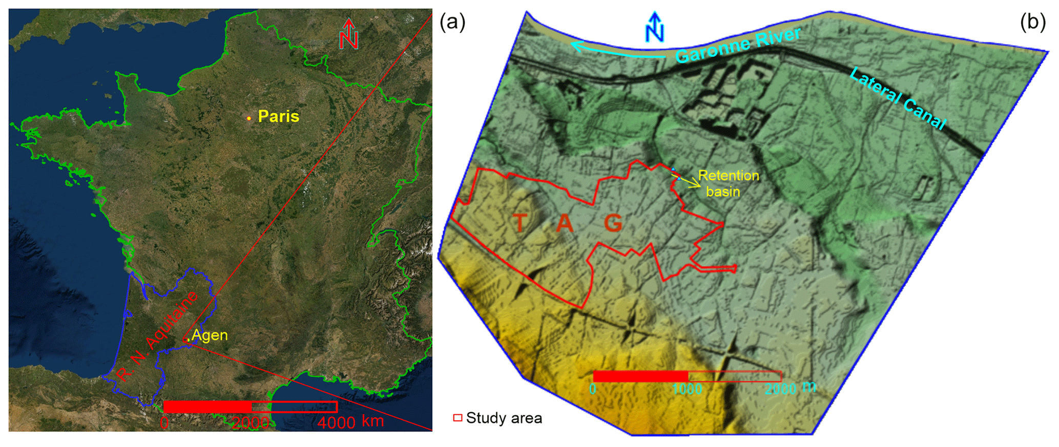
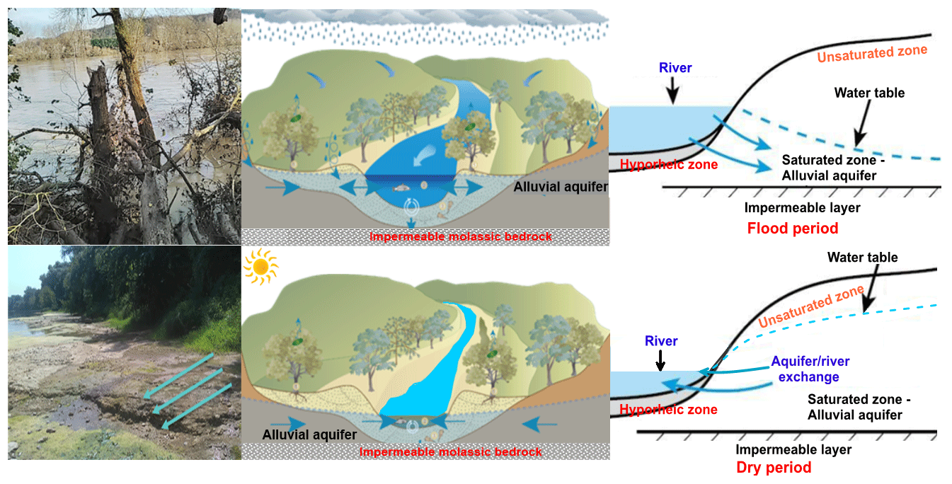
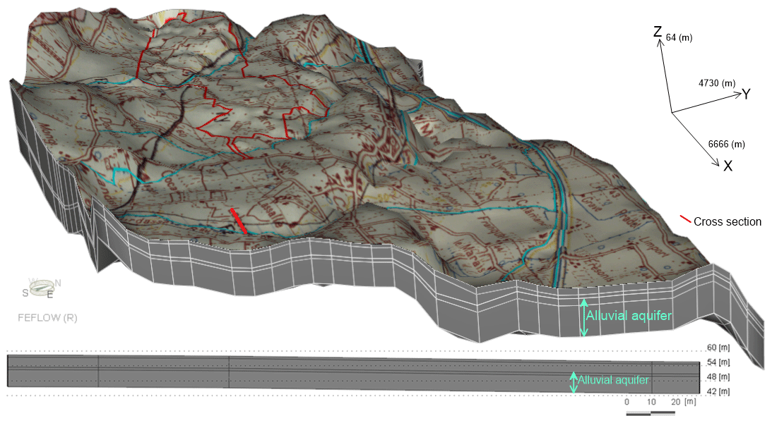
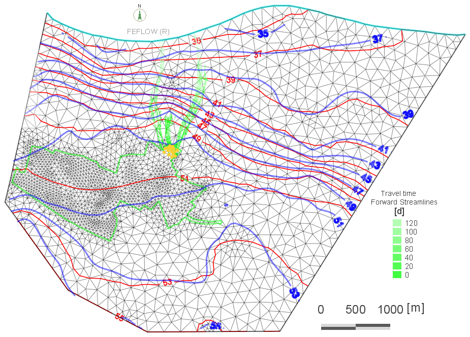
The Garonne River is the primary river in the southwest part of France. The Quaternary alluvial aquifer along this River may represent a substantial water resource, especially for agricultural activities well-developed in the Garonne Valley. However, this shallow aquifer hosts numerous irrigation wells reducing the baseflow during the intensive pumping periods. It is recharged by rainfall, lateral inflow from the hillside (overlying terraces), and the river bed seepage during the flood periods. The aquifer sustains the River during the dry periods. Furthermore, the potential recharge of this aquifer is particularly sensitive to annual climate fluctuation and consequently affects the ecosystems and related socio-economy. Groundwater artificial recharge can be considered an innovative and sustainable nature-based solution. The runoff water from The Techno-Pole Agen – Garonne (TAG) zone is collected in retention basins and is a potential source to recharge the shallow alluvial aquifer. The study aims to model water infiltration and understand the aquifer response and, consequently, the effects on river low flow. Within the framework of this study, 132 wells/boreholes were used in to determine the groundwater level fluctuations and to create its maps. The measurements showed that the artificial recharge increased the groundwater level by more than 1 m close to the retention basin after the rainstorm event. Similarly, a three-dimensional (3D) groundwater model shows a similar magnitude aquifer response to the induced infiltration. Consequently, this model satisfactorily represents the interest of the artificial recharge of the alluvial aquifer and permits predictions about whether the aquifer can maintain the low flow of in the Garonne River. To this end, it was estimated that the infiltrated water would take about 4 months to reach the River, which is an appropriate time to sustain it during the dry periods.

Keywords

Climate change; Alluvial aquifer; Artificial recharge; Groundwater modelling; Water resources management, Garonne valley; France

1 Introduction

After the Loire and Seine, the Garonne River is the third of the large French Atlantic rivers. Its drainage basin has an area of 57 000 km2 (Lancaster, 2005) and up to Tonneins, the last gauging station uninfluenced by the tidal action, it is calculated to be 50 000 km2 (Biancamaria et al., 2019). The Garonne Basin is mainly influenced by the Oceanic and Mediterranean climate as well as snowmelt from the mountainous areas.

In the Garonne Valley, water is a crucial element for economic and social development. Both surface water and groundwater resources usually meet the needs of all uses. However, the spatial and temporal distribution of these resources does not always match the demands. Several studies have mentioned how the current and future negative impacts of climate change influence the hydrology of the Garonne River and its surrounding alluvial aquifers (Caballero et al., 2007; Hendrickx and Sauquet, 2013; Agence de l'eau Adour-Garonne, 2014; Guivarch et al., 2015; Le Treut, 2018).

https://piahs.copernicus.org/articles/385/53/2024/piahs-385-53-2024-f01

Figure 1Map of France, prepared by QGIS, free and open source software, showing the location of the study area in Nouvelle Aquitaine Region (a) and the topographic units of the study area according to IGN (French national geographic institute) spatial satellite data with a 5 m resolution (b).

Groundwater and surface water resources interact in a range of geological, topographical, and climatic settings, and they have varying degrees of connection (Ivkovic, 2009). The shallow alluvial aquifer system investigated in this work overlies an impermeable layer of Tertiary Molasse sediments and it supplies water to thousands of irrigation wells. According to the location and the degree of incision of the River into the Tertiary Molasse, the Garonne River can temporarily recharge the alluvial aquifer during flood periods. On the other hand, this aquifer drains and sustains the low flow of the River during dry periods. This aquifer drainage takes place mainly in summer and is often the main source for the River during this period (Brugeron et al., 2018). The impacts of climate change on the water resources in the Garonne Valley lead to seeking adaptation strategies, including artificial aquifer recharge.

The Techno-Pole Agen - Garonne (TAG) project is under construction close to the City of Agen southwest France. The project and its surrounding areas (about 20 km2), where the current major occupation is essentially agricultural activities, are taken as a study area. The alluvial aquifer in this area will be used as a potential source to create a peri-urban, natural, green, and temperate zone in order to combat rising temperatures. The study aims to: (1) determine the potential response of the alluvial aquifer to artificial recharge; (2) identify how this strategy will participate in increasing the baseflow toward the Garonne River during dry periods and (3) recognize the potential of this strategy as a management tool in the Garonne Valley to mitigate the impacts of climate change on water resources.

2 Materials and methods

2.1 Study area

The study area is located in the southwest of France (Fig. 1). The TAG Project is considered as one of the most important project from the economical point of view in the southwest of the region. It is under construction within an area of about 240 ha near Agen. The project zone and surrounding area were taken as a study area (≈20 km2). This area is characterized by a temperate transitional climate between the Oceanic and Mediterranean regimes. It is characterized in the south and southwest by hillsides, while the floodplain is dominated in the north and northeast. The relief, according to IGN (French national geographic institute) spatial satellite data with a 5 m resolution, ranges from about 83 m in the south toward the hillsides to 32 m in the north near the Garonne River.

The alluvial deposits are dominant in the study area (Danneville, 2016). The low alluvial plain, consisting of gravel and large pebbles intercalate with a sandy matrix, occupies the north and northeast parts. In contrast, the low terrace predominantly contains weathered deposits of silt and sandy-clay. The alluvial deposits are limited at the bottom by the molassic layer. The thickness of these deposits is between 6 to 10 m and decreases towards the hillside, where the silt, clay, and sand cover intercalates with the aeolian sediments of the hills.

https://piahs.copernicus.org/articles/385/53/2024/piahs-385-53-2024-f02

Figure 2Alluvial aquifer/Garonne River interface and exchange patterns during flood and dry periods, after the Rhône Mediterranean and Corse Water Agency and Queensland Government.

Download

The substantial variation in the sedimentological composition of the alluvial deposits induces subsurface heterogeneity leading to an important change in hydraulic properties of the alluvial aquifer over several orders of magnitude in a relatively small area. The hydraulic conductivity values of this aquifer vary from 10−2 to 10−5 m s−1.

https://piahs.copernicus.org/articles/385/53/2024/piahs-385-53-2024-f03

Figure 3Location maps of observation wells (left) and monthly groundwater level fluctuations in two boreholes located close to the retention basin, as well as monthly rainfall variation measured in Agen station close to the TAG area.

2.2 Methods

2.2.1 The observed relationship between the alluvial aquifer and the Garonne River in the study area

The impermeable molassic rocks that form the riverbed of the Garonne River are characterized by a low altitude compared with the adjacent alluvial aquifer. The alluvial aquifer is characterized by a shallow flushed system that drains into the River during low flow periods when the groundwater level is higher than the river level. Conversely, during the flood periods, when the river level is higher than the groundwater level, the surface water seeps and recharges the aquifer either through the river banks if they are not clogged or through the infiltration when the river water reaches about 2 km further from the River in the flooded plain. However, the exchanges between the aquifer and the River depends on the River's head (Fig. 2).

https://piahs.copernicus.org/articles/385/53/2024/piahs-385-53-2024-f04

Figure 4The three-dimensional (3D) representation model of the study area.

Download

These exchanges have significant quantitative and qualitative consequences, particularly during low-flow periods when the aquifer contributes to maintain the River's flow and its thermal buffering capacity. The river temperature was measured locally as 29 °C in August 2019 while the temperature of the drained groundwater in the River was 15 °C in the same period.

2.2.2 Potential of artificial recharge of the alluvial aquifer in the TAG area

Based on the observed hydraulic relationship between the Garonne River and the adjacent alluvial aquifer, the artificial recharge of this aquifer has been initiated.

The runoff water in the TAG area is collected in the retention basins in order to enhance the recharge of the aquifer and its later use. Following the storm event of November 2019, the retention basin has filled up. Consequently, the infiltrated water has created a piezometric dome that has been observed in the two boreholes (PZ1 and PZ6) located near the basin where the groundwater level has increased by about 1m (Fig. 3).

https://piahs.copernicus.org/articles/385/53/2024/piahs-385-53-2024-f05

Figure 5Measured and calculated groundwater level maps, March–2019.

https://piahs.copernicus.org/articles/385/53/2024/piahs-385-53-2024-f06

Figure 6Groundwater flow patterns towards the Garonne River after artificial recharge applied in the TAG area.

3 Groundwater modeling result

By using FEFLOW (DHI-WASY 2010) and according to IGN (French national geographic institute) spatial satellite data with a 5 m resolution, the two-dimensional (2D) horizontal finite element mesh was generated. After that, the three-dimensional (3D, Fig. 4) slice elevations, layer properties and boundary conditions were defined.

The model domain was discretized into elements and nodes with five model layers. The first layer represents vegetal soil, its thickness changes between 1–3 m. The second layer consists of silt and sandy silt with a thickness changes between 1–7 m. The third layer represents a thin sandy layer with a thickness ranging from 1 to 2 m. The fourth one constitutes the alluvial aquifer (gravels, pebbles, and sandy-clay) housed in the molassic formations with a thickness varying from 6 to 10 m.

The calibrated hydraulic conductivity values with the inverse method in a steady state, in order to simulate the measured hydraulic heads, shows that these values change between 10−2 and 10−5. The calibrated model has allowed us to specify the spatial distribution of the aquifer permeability and to visualize the main flow directions in relation to the equipotential lines. These lines show that the infiltration basin is located in an area characterized by relatively high permeability.

The superposition of the measured and calculated groundwater level contours (Fig. 5) for the same period indicates a good agreement. The two sets of piezometric contours, plotted every 2 m, are relatively close to each other over the whole study area.

The calibrated model has defined the initial groundwater level, which is used to run it in the transient regime taking into account the effect of artificial recharge from the retention basin (Fig. 6). A piezometric dome and significant rise in groundwater level can be observed near the retention basin after storm events and, consequently, runoff water infiltration (Fig. 6). Thus, the initial piezometric contour value has moved about 500 m toward a groundwater flow direction.

The results show that the infiltrated water during March-April takes about 4 months to reach the Garonne River which is an appropriate time to sustain the low flow of the river.

4 Conclusions

The application of artificial recharge of the alluvial aquifer in the study area is found to be a significant tool to maintain groundwater level. Groundwater modelling results show how this mechanism can be used to sustain the low flow of the Garonne River. It was estimated that the infiltrated water would take about 4 months to reach the River, which is an appropriate time to sustain it during the dry periods if the recharge takes place between January and April. This pragmatic and potentially eco-responsible management tool can be considered as an adaptation strategy to climate change in the whole Garonne Valley.

Based on the obtained results of this project, three other pilot sites in the Garonne valley were selected to be studied and subsequently evaluate their potential for artificial recharge using the Canal Lateral of the Garonne River as a source. This will help to recharge the Garonne River during the dry period with thermally tempered water and contribute to proper functioning of its environment. However, this methodology is appropriate to preserve the water resources in the study area and to maintain the agricultural activities of the inhabitants, who depend mainly on agricultural production.

Data availability

No data sets were used in this article.

Author contributions

All the authors contributed to the work presented in this paper and commented on the manuscript at all stages. NA, AD and BL designed the methodological framework and revisions. NA and AD performed the simulation and analysed the results. NA prepared the manuscript with contributions of AD and BL.

Competing interests

The contact author has declared that neither of the authors has any competing interests.

Disclaimer

Publisher’s note: Copernicus Publications remains neutral with regard to jurisdictional claims in published maps and institutional affiliations.

Special issue statement

This article is part of the special issue “IAHS2022 – Hydrological sciences in the Anthropocene: Variability and change across space, time, extremes, and interfaces”. It is a result of the XIth Scientific Assembly of the International Association of Hydrological Sciences (IAHS 2022), Montpellier, France, 29 May–3 June 2022.

Acknowledgements

We thank the ACMG (Climatological Association of the Middle Garonne) for their technical support.

Financial support

This research has been supported by the Nouvelle Aquitaine Region (File no 2017-1R20104) and by SMEAG, Syndicat mixte d'études et d'aménagement de la Garonne (File no CT_2019-068).

Review statement

This paper was edited by Christophe Cudennec and reviewed by two anonymous referees.

References

Agence de l'eau Adour-Garonne: Eau et Changements climatiques en Adour-Garonne, Les enjeux pour la ressource, les usages et les milieux, http://oai.eau-adour-garonne.fr/oai-documents/60721/GED_00000000.pdf (last access: 4 March 2022), 2014. 

Biancamaria, S., Mballo, M., Le Moigne, P., Sánchez Pérez, J. M., Espitalier-Noël, G., Grusson, Y., Cakir, R., Häfliger, V., Barathieu, F., Trasmonte, M., Boone, A., Martin, E., and Sauvage, S.: Total water storage variability from GRACE mission and hydrological models for a 50 000 km2 temperate watershed: the Garonne River basin (France), J. Hydrol., 24, 100609, https://doi.org/10.1016/j.ejrh.2019.100609, 2019. 

Brugeron, A., Schomburgk, S., Cabaret, O., Bault, V., Bel, A., Salquebre, D., Fourniguet, G., Lamotte, C., and Parmentier, M.: Synthèse sur la cartographie et la caractérisation des alluvions dans le référentiel hydrogéologique BDLISA, Rapport final BRGM/RP-67533-FR, 2018. 

Caballero, Y., Voirin-Morel, S., Habets, F., Noilhan, J., Le Moigne, P., Lehenaff, A., and Boone, A.: Hydrological sensitivity of the Adour-Garonne river basin to climate change, Water Resour. Res., 43, W07448, https://doi.org/10.1029/2005WR004192, 2007. 

Danneville, L.: Contribution des eaux souterraines aux débits et à la qualité des eaux de surface – Exemple de la Garonne, de ses sources à la confluence du Tarn, https://tel.archives-ouvertes.fr/tel-01420437 (last access: 18 March 2022), 2016. 

DHI-WASY GmbH: FEFLOW 6, Finite elements subsurface flow and transport simulation system, In User's Manual, DHI-WASY GmbH: Berlin, Germany, 2010. 

Guivarch, M., Dany, A., Toulzac, N., Guiheux, A., and Le Gall, G.: État Initial du SAGE Vallée de la Garonne, Rapport, Version 6, Février 2015. 

Hendrickx, F. and Sauquet, E.: Impact of warming climate on water management for the Ariège River basin (France), Hydrolog. Sci. J., 58, 976–993, https://hal.archives-ouvertes.fr/hal-01117889v2, 2013. 

Ivkovic, K. M.: A top-down approach to characterise aquifer-river interaction processes, J. Hydrol., 365, 145–155, https://doi.org/10.1016/j.jhydrol.2008.11.021, 2009. 

Lancaster, R. R.: Fluvial evolution of the Garonne River, France: integrating field data with numerical simulations, https://digitalcommons.lsu.edu/gradschool_theses/3351 (last access: 18 March 2022), 2005. 

Le Treut, H.: Les impacts du changement climatique en Aquitaine, in: L'air et l'eau – Presses Universitaires de Bordeaux, chapitre 8, https://books.openedition.org/pub/663?lang=fr{#}text (last access: 10 March 2022), 2018. 

Queensland Government: Groundwater dependent ecosystem pictorial conceptual model “alluvia”: version 1.5, Queensland Government, Brisbane, 2017. 

QGIS Development Team (2019): QGIS Geographic Information System, Open Source Geospatial Foundation Project, http://qgis.osgeo.org, last access: 12 November 2019. 

Download
Short summary
In the Garonne valley, water is extremely important. In addition to the Garonne River, its accompanying alluvial aquifer located in the valley, is identified as an essential reservoir. This aquifer is in hydraulic contact with the river. Artificial groundwater recharge is one of the possible adaptation strategies in water resource management. It is economically interesting to improve the quantitative and qualitative status of groundwater bodies, and it can respond to local problems.