the Creative Commons Attribution 4.0 License.
the Creative Commons Attribution 4.0 License.
 | 19 Apr 2024
Analyzing the Effects of Climate Change for the Water Tower of Mesopotamia, Türkiye
Gokcen Uysal
Yusuf Ogulcan Dogan
Huseyin Soykan Civelek
Ali Arda Sorman
Aynur Sensoy
This study aims to analyze future snowmelt runoff and snow extent for the Upper Euphrates Basin (41 109 km2) which is the most upstream basin of the water tower Mesopotamia and located in the Eastern mountainous part of Türkiye. The future characterization of snowmelt runoff and snow water equivalent is investigated taking the regional climate model projections into account through hydrological model applications. The basin is divided into two major sub-basins Karasu Basin and Murat Basin. The conceptual hydrological models, HBV and HEC-HMS have been utilized to establish a rainfall-runoff relationship. The models are calibrated and validated with observed daily total precipitation and average temperature data for the 1980–2011 period. Future projections are selected for the 2025–2100 periods using EU-CORDEX data with various global circulation models. MPI-ESM-LR and CNRM-CM5 data sets and RCP4.5 and RCP8.5 emission scenarios are used for future projections. The results indicate a decrease in snow cover extent and an increase in snowmelt runoff. The overall assessment will help us to understand how these changes will affect the operations of water resources systems (downstream reservoirs) in terms of flood control, energy production, irrigation, water supply, etc.
- Article
(2637 KB) - Full-text XML
- BibTeX
- EndNote


Hydrological modelling; Climate change; Snowmelt; Euphrates River Basin; UPH 2
Global climate change greatly affects climatological and hydrological elements like temperature, precipitation regime, groundwater levels and hydrological response (Gleick, 1989). Although floods and droughts are/will be the main expected consequences in the future, also it is expected that global change will have different effects on each region (Tabari, 2020). Therefore, the assessment of potential impacts of climate change on regional water resources is receiving growing attention from various researchers. The Mediterranean Basin has been identified as one of the world's most sensitive regions to climate change consequences (URL-1, 2022). Fujihara et al. (2008) explored the potential impacts of climate change on the Seyhan River Basin in Türkiye and concluded an increase in temperature and a reduction in precipitation for future projections. Bozkurt and Sen (2013) investigated future climate change in the Euphrates–Tigris Basin using dynamically downscaled outputs of different Global Circulation Models (GCMs) and emissions scenario simulations for two 30 year periods, 2041–2070 and 2071–2099. According to their analyses, significant decreases in the annual surface runoff is expected.
GCMs are generally used in large-scale climate change impact studies and play a key role in recognizing future global climatic changes (Fujihara et al., 2008). The model outputs necessitate a proper hydrological modeling background to produce future projections. The eastern part of Türkiye is covered with full or partially snow during winter and large rivers such as Euphrates and Tigris are mainly fed by the snowmelt. This study aims to project future runoff and snow components in the snow-dominated basins of the Euphrates River basin by integrating climate model data sets and two well-known conceptual hydrological models.
This section briefly describes the data used for the set-up and the structures of hydrological modelling approaches together with the climate data and their assessment for the future projections. Hydrological modelling is accomplished with two conceptual models: HBV-Light and HEC-HMS. After calibrating and validating models, GCM data set based runs are employed to simulate the historical and future changes. The changes over the reference period are calculated for runoff and snow components.
2.1 Hydro-Meteorological and Climate Data
Türkiye has a complex topography and variable climate. Two upstream snow-dominated catchments (Fig. 1) are selected; Karasu Basin (15 330 km2) and Murat Basin (25 779 km2) having the elevation ranges between 860–3565 and 840–4045 m, respectively. Annual total precipitation is 429.3 and 593.9 mm yr−1, annual average temperature is 9.1 and 8.2 °C and annual average discharge is 153.5 and 239.0 m3 s−1 between 1980-2011 for Karasu and Murat, respectively. These basins play an important role in downstream water structures. The region is also the concern of various national and international projects (Şensoy and Uysal, 2012; Uysal et al., 2016; Şorman et al., 2019; Uysal and Şorman, 2021).
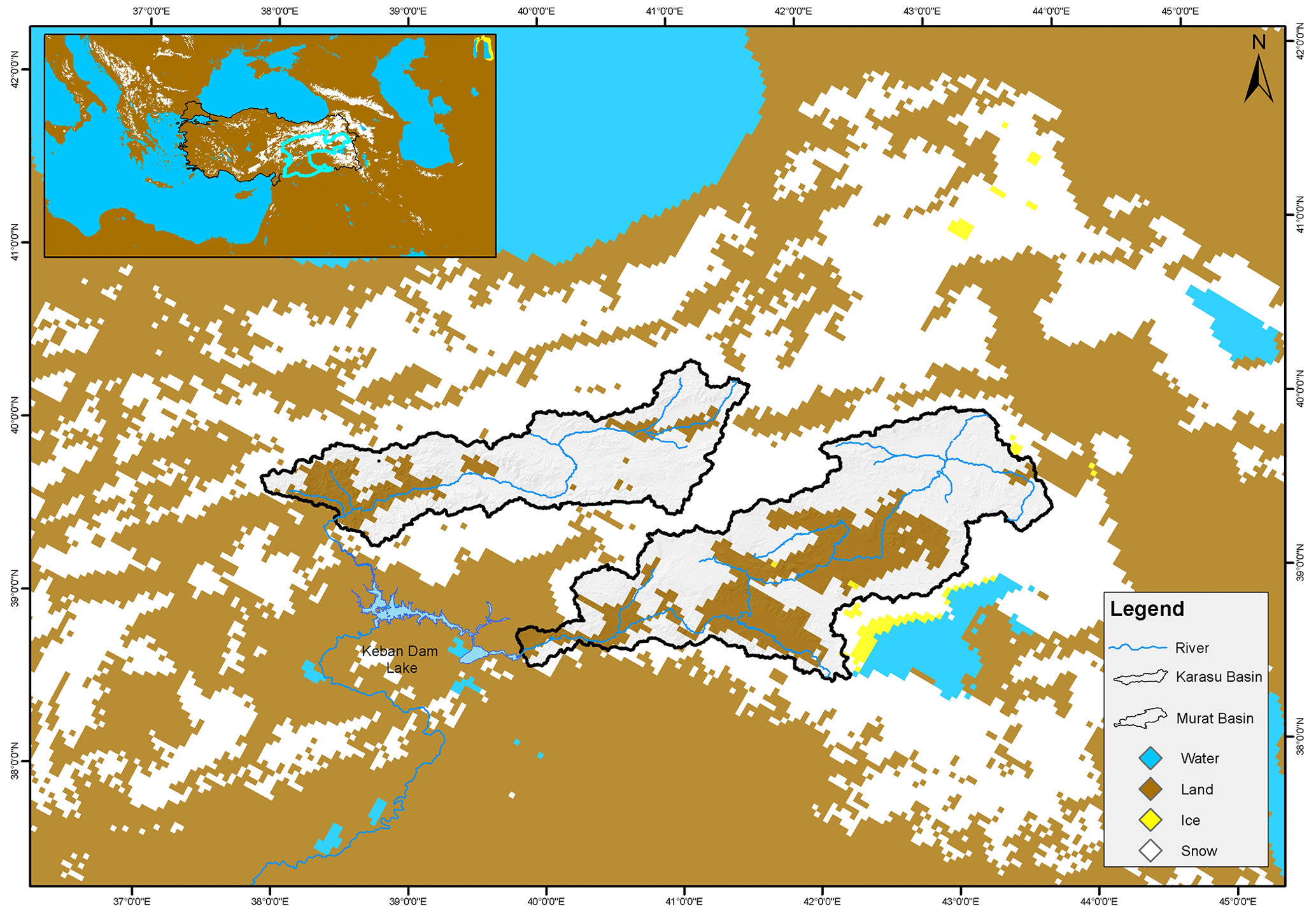
Figure 1Snow cover across Türkiye from IMS satellite (30 March 2009) and the selected catchments on the Euphrates River.
Historical simulations and projections of future changes in precipitation and temperature are provided by the EURO-CORDEX platform (URL-2, 2021). MPI-ESM-LR and CNRM-CM5 GCMs data sets having RCP4.5 and RCP8.5 concentration scenarios with 112.5 km spatial resolution are selected in the study. Data over the basin are derived from Regional Climate Model (RCM) ModeRegCM4.3.4 to provide a series of high-resolution inputs (20 km resolution). Linear bias correction is applied for precipitation and temperature data sets. Stationary climate simulations are used for reference (1971–2000) and future (2025–2100) periods. The future projection period is evaluated under 2025–2050, 2051–2075, and 2076–2100 periods.
2.2 HBV Hydrological Model
The Swedish Meteorological and Hydrological Institute (SMHI) developed HBV as a conceptual and continuous hydrological model (Bergström, 1995). The HBV-Light version (Seibert and Vis, 2012) was utilized in this study as it offers a user-friendly graphical interface and an automatic calibration opportunity. The HBV model distributes precipitation, temperature, and potential evapotranspiration inputs based on elevation and vegetation zones. The model calculates snow and soil moisture layers based on zones, as well as runoff and routing processes for the entire basin, to mimic daily flow.
2.3 HEC-HMS Hydrological Model
HEC-HMS (Hydrologic Modeling System) model is developed by the U.S. Army Corps of Engineers Hydrologic Engineering Center (USACE) and is designed to simulate the rainfall-runoff process of dendritic watershed systems as continuous or event-based and to be applicable in a wide range of geographic areas (Scharffenberg and Fleming, 2000). Inputs are precipitation, temperature, and potential evapotranspiration. In this study, soil moisture accounting (SMA), linear reservoir and Clark unit hydrograph method are chosen respectively as a loss, baseflow and transform methods. SMA module considers continuous situation-based soil moisture variation which is carried out by calculating the amount of water stored in and moving through vegetation, soil surface, profile and groundwater layers. Linear reservoir method is more compatible with SMA.
2.4 Assessment Metrics
Nash-Sutcliffe Efficiency (NSE), Killing-Gupta Efficiency (KGE) and Pearson correlation coefficient (r) are used to test hydrological model performances (Eqs. 1–4):
where x is observation, y is modelled value, is average observation, is average modelled value, Sx is the standard deviation of the observed data, Sy is the standard deviation of the modelled data, n is the number of data sets.
Contingency tables evaluate the consistency by using two main indicators i.e., Probability of Detection (POD) (Eq. 5) and False Alarm Rate (FAR) (Eq. 6).
where “a” (detected by both ground and GMC), “b” (detected by only GCM), “c” (detected by only ground) and “d” (no detection in both).
3.1 Hydrological Modelling Performances
The conceptual daily hydrological models are calibrated and validated from 1980–2011. Tables 1 and 2 show that the HBV model has a higher model efficiency for both basins and periods. The performance of HBV is slightly better than the HEC-HMS model in terms of NSE, mainly associated with peak flow accuracy. KGE accounts for various components and both models show similar performances in Karasu.
Table 1Model performances for Karasu basin.
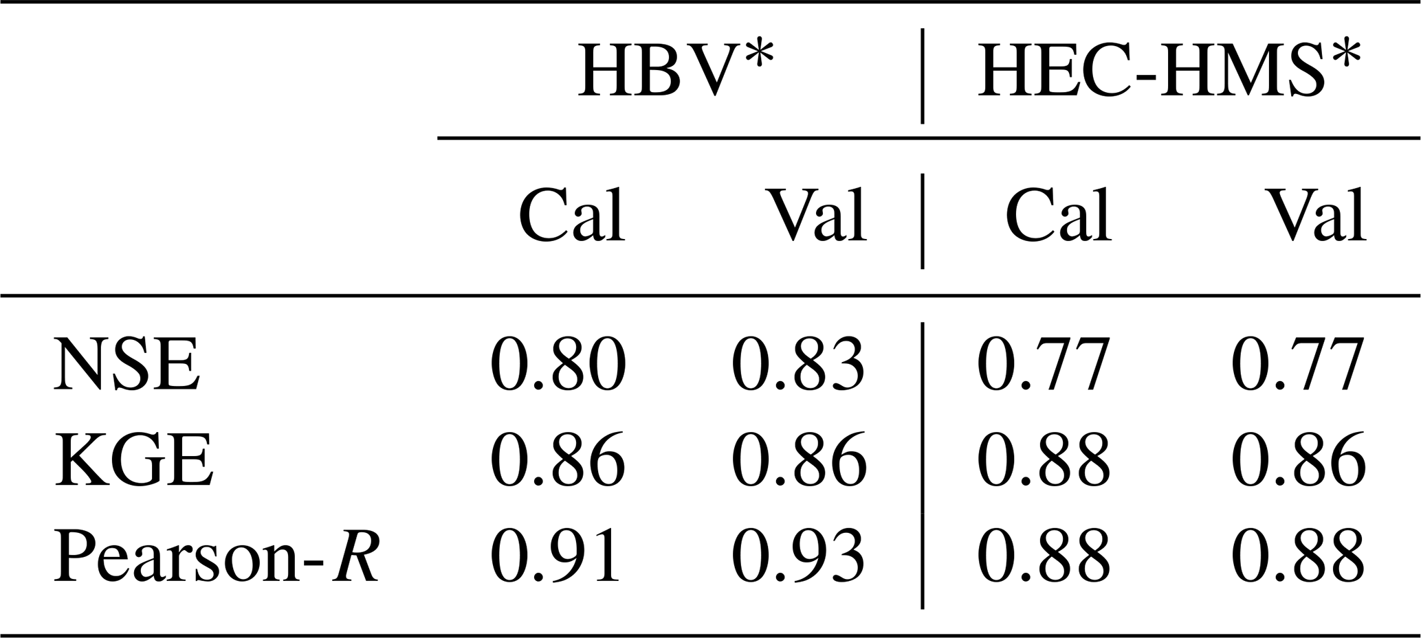
∗Cal: 1980–1999, Val: 1991–2011.
Table 2Model performances for Murat basin.
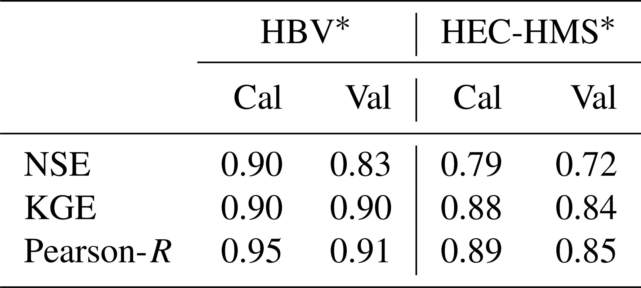
∗Cal: 1980–1999, Val: 1991–2011.
3.2 Raw and Bias-Corrected Climate Data Performances
Bias correction is applied for temperature and precipitation GCM data sets. Performances of the raw and bias-corrected GCMs data sets are compared with gauge measurements for the reference period. Pearson-R values of monthly average bias-corrected temperature against gauge measurement are around 0.96 for MPI-ESM-LR and CNRM-CM5 in both basins. Figure 2 depicts both basins' POD and FAR values with monthly (mo) threshold precipitations. POD values increased in both products after the bias correction application. CNRM-CM5 performs slightly better in comparison with MPI-ESM-LR.

3.3 Future Projections
The performances of the hydrological models, GMCs data are assessed and the change in future projections (runoff and SWE) are demonstrated against the reference period. Future projections are assessed for RCP8.5 as the worst-case scenario (Fig. 3). Both models demonstrate a possible increase in the runoff for two mountainous basins (more emphasized for Karasu Basin) for the first two projection periods and a significant decrease for the last projection period according to MPI-ESM-LR based GCM. CNRM-CM5 based hydrological model results indicate a variational change with low percentages for the first two projection periods, however, an increase in runoff for the last projection period for both basins. These mismatches might be assigned to variations of precipitation in each GCM in each period.
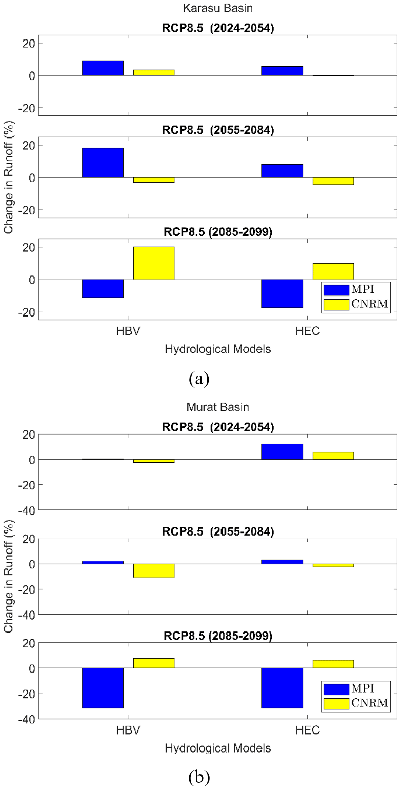
Figure 3The change in runoff for three future projections (a) Karasu Basin, (b) Murat basin.
Figure 4 depicts the change in snow water equivalent (SWE) in terms of percentages in the future projections. Regardless of the hydrological model and GCM, the reduction is expected in future SWE values. Fewer reduction is expected for the 2024–2054 period. The reductions are exacerbated along with a longer lead time period. This might be attributed to the increase in temperature in the future.
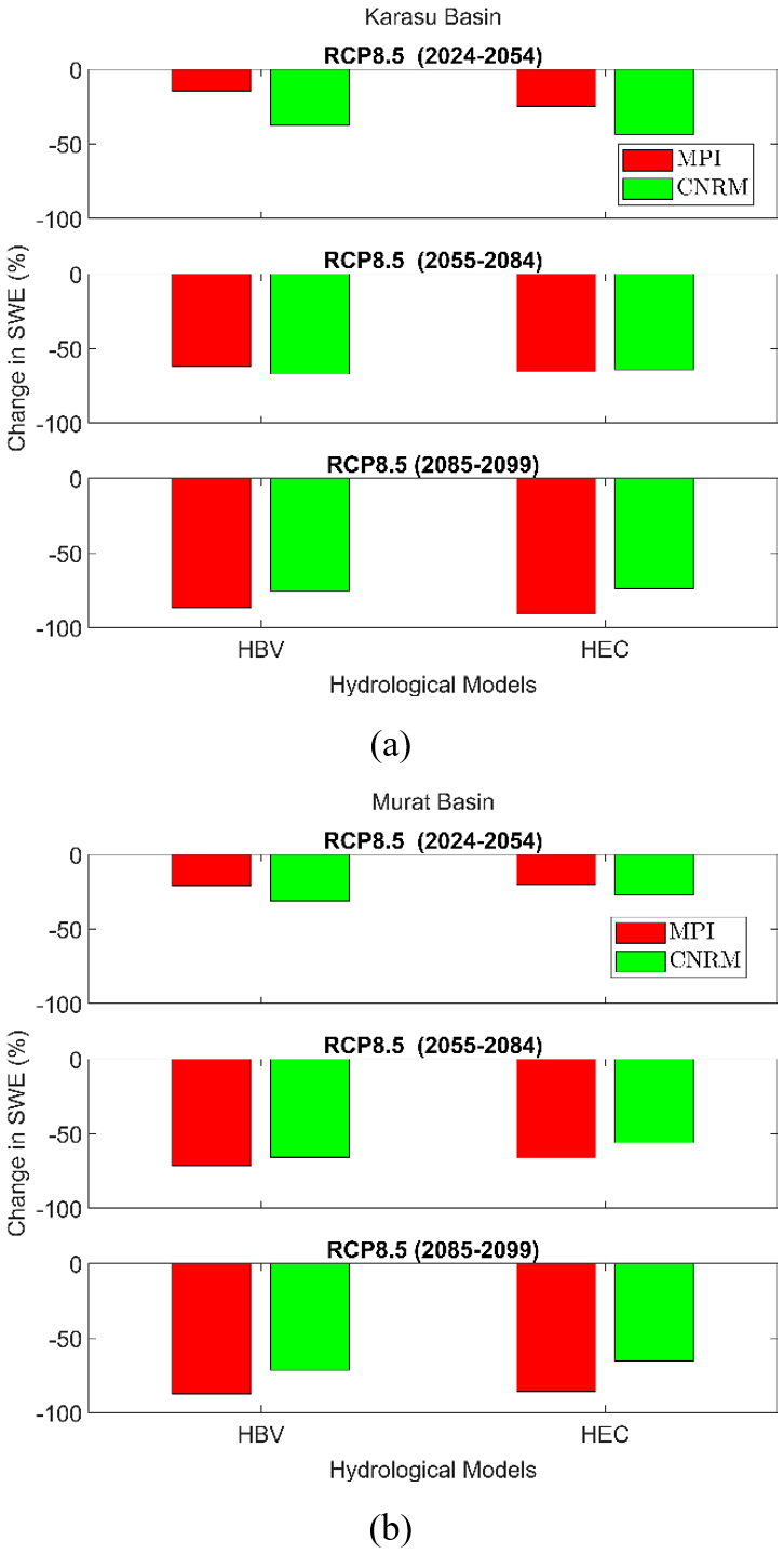
Figure 4The change in snow water equivalent (SWE) for three future projections (a) Karasu Basin, (b) Murat basin.
3.4 Discussion of the Results
A bias correction is required for GCM data sets, however the improvement for precipitation data is limited compared to the temperature data. Both hydrological models (HBV and HEC-HMS) provide satisfactory calibration and validation performances. The change in runoff is variable depending on GCM data set. For example, MPI-ESM-LR based runoff present no change or slight increase for change in percent runoff between 2024–2054 and 2055–2084, however an increase is expected for 2085–2099. On the other hand, the change for CNRM-CM5 is either vice versa or less. The future projection of the SWE is decreasing related to the increase in temperature data. Climate change will alter snowfall to rainfall, thus will have various impacts on surface runoff and snow extent.
The study investigates the future implications of snowmelt runoff against the changing climate for the upstream part of the Euphrates River. EU-CORDEX GCM data sets MPI-ESM-LR and CNRM-CM5 are accounted to estimate future projections of discharge and SWE. The study accounts different hydrological models (HBV & HEC) in the assessment. Both hydrological models provide satisfactory validation NSE values (0.84–0.90). The bias correction is required for GCM data sets before using them in the models. A possible increase in the runoff for the first two projection period, and a significant decrease for the last projection period especially according to MPI-ESM-LR are expected. These results indicate a drastic and continuous decrease in SWE due to changes in the temperature. These changes will negatively affect the operation of reservoirs, the agriculture policy, and tourism management. Nonetheless of model selection, change in precipitation holds more uncertainty which might cause the variation in streamflow runoff. Changes in snow line elevation and lag time are being assessed in future studies. Considering the variation in GCMs, increasing the number of climate models would provide more information to interpret the results.
Publicly available free climate datasets (https://esg-dn1.nsc.liu.se/search/cordex/, ESGF, 2024) are analyzed in this study. The hydro-meteorological data set is not public or open to third parties.
GU analyzed the data, wrote the draft; YOD and HSC performed the model simulations; AS designed the research; GU, YOD, HSC, AS, AAS reviewed and edited the manuscript.
The contact author has declared that none of the authors has any competing interests.
Publisher’s note: Copernicus Publications remains neutral with regard to jurisdictional claims made in the text, published maps, institutional affiliations, or any other geographical representation in this paper. While Copernicus Publications makes every effort to include appropriate place names, the final responsibility lies with the authors.
This article is part of the special issue “IAHS2022 – Hydrological sciences in the Anthropocene: Variability and change across space, time, extremes, and interfaces”. It is a result of the XIth Scientific Assembly of the International Association of Hydrological Sciences (IAHS 2022), Montpellier, France, 29 May–3 June 2022.
Special thanks are extended to the State Hydraulics Works of Türkiye (DSI) as well as the Turkish State Meteorological Service (MGM).
This research has been supported by Eskisehir Technical University (Scientific Research Projects 22DRP190 and 22ADP051).
This paper was edited by Christophe Cudennec and reviewed by two anonymous referees.
Bergström, S.: The HBV model, in: Computer models of watershed hydrology, edited by: Singh, V. P., Water Resources Publications, Highlands Ranch, Colorado, USA, 443–476, ISBN 9780918334916, 1995.
Bozkurt, D. and Sen, O. L.: Climate change impacts in the Euphrates–Tigris Basin based on different model and scenario simulations, J. Hydrol., 480, 149–161, https://doi.org/10.1016/j.jhydrol.2012.12.021, 2013.
ESGF: ESGF@LiU/CORDEX, MPI-ESM-LR (Max Planck Institute Earth System Model running on low resolution grid) and CNRM-CM5 (Centre National de Recherches Météorologiques-climate model version 5), Earth System Grid Federation (ESGF) [data set], https://esg-dn1.nsc.liu.se/search/cordex/, last access: 5 February 2024.
Fujihara, Y., Tanaka, K., Watanabe, T., Nagano, T., and Kojiri, T.: Assessing the impacts of climate change on the water resources of the Seyhan River Basin in Turkey: Use of dynamically downscaled data for hydrologic simulations, J. Hydrol., 353, 33–48, https://doi.org/10.1016/j.jhydrol.2008.01.024, 2008.
Gleick, P. H.: Climate change, hydrology, and water resources, Rev. Geophys., 27, 329–344, 1989.
Scharffenberg, W. A. and Fleming, M. J.: Hydrologic Modeling System-HEC-HMS-User's Manual-Version 2.0, ASIN B0006RUUPC, 2000.
Seibert, J. and Vis, M. J. P.: Teaching hydrological modeling with a user-friendly catchment-runoff-model software package, Hydrol. Earth Syst. Sci., 16, 3315–3325, https://doi.org/10.5194/hess-16-3315-2012, 2012.
Şensoy, A. and Uysal, G.: The value of snow depletion forecasting methods towards operational snowmelt runoff estimation using MODIS and Numerical Weather Prediction Data, Water Resour. Manag., 26, 3415–3440, https://doi.org/10.1007/s11269-012-0079-0, 2012.
Şorman, A. A., Uysal, G., and Şensoy, A.: Probabilistic snow cover and ensemble streamflow estimations in the Upper Euphrates Basin, J. Hydrol. Hydromech., 67, 82–92, https://doi.org/10.2478/johh-2018-0025, 2019.
Tabari, H.: Climate change impact on flood and extreme precipitation increases with water availability, Sci. Rep., 10, 13768, https://doi.org/10.1038/s41598-020-70816-2, 2020.
URL-1: https://climate-adapt.eea.europa.eu/, last access: 25 March 2022.
URL-2: https://www.euro-cordex.net/, last access: 1 December 2021.
Uysal, G. and Şorman, A. Ü.: Evaluation of PERSIANN family remote sensing precipitation products for snowmelt runoff estimation in a mountainous basin, Hydrolog. Sci. J., 66, 1790–1807, https://doi.org/10.1080/02626667.2021.1954651, 2021.
Uysal, G., Şensoy, A., and Şorman, A. A.: Improving daily streamflow forecasts in mountainous Upper Euphrates basin by multi-layer perceptron model with satellite snow products, J. Hydrol., 543, 630–650, https://doi.org/10.1016/j.jhydrol.2016.10.037, 2016.