the Creative Commons Attribution 4.0 License.
the Creative Commons Attribution 4.0 License.
 | 19 Apr 2024
Evaluation and calibration of alternative methods for estimating reference evapotranspiration in the main hydrosystems of Senegal: Senegal, Gambia and Casamance River Basins
Ansoumana Bodian
Papa Malick Ndiaye
Serigne Bassirou Diop
Lamine Diop
Alain Dezetter
Andrew Ogilvie
Koffi Djaman
Reference evapotranspiration (ET0) is an essential parameter for hydrological modeling, irrigation planning and for studying the impacts of climate change on water resources. The Penman–Monteith method is recommended for estimating ET0 under all climatic conditions, but its application is limited in regions where data is difficult to access. The alternative is to use methods that incorporate fewer climatic parameters. The objective of this work is to evaluate twenty alternative methods using few climate parameters of estimating ET0 and to calibrate/validate the best ones in order to adapt them to the climatic context of the main hydrosystems of Senegal: Senegal, Gambia and Casamance river basins. The KGE and the PBIAS were used to evaluate the performance of the methods. The results show that after calibration/validation the methods of Trabert, Hargreaves, Hargreaves & Samani, Trajkovic and Oudin are the best on for the estimation of the reference evapotranspiration in the Senegal, Gambia and Casamance River Basins.
- Article
(4773 KB) - Full-text XML
- BibTeX
- EndNote


UPH1; SDG6; Reference evapotranspiration; Senegal; Gambia; Casamance River Basins
The estimation of evapotranspiration is a major difficulty in the context of developing countries. This is generally explained by the difficulty of accessing the climatic data necessary for its estimation and the low density of measurement stations. To overcome this, reanalysis data can be an alternative to often incomplete observed data. These data give the opportunity to calculate the evapotranspiration with several methods. The latter vary according to the climatic parameters that they integrate. A distinction is made between aerodynamic methods according to which evapotranspiration is proportional to wind speed and saturation deficit (Dalton, 1802), methods based on temperature (Hargreaves, 1975) and solar radiation (Makking, 1957) and those based on which combine several climatic variables (Penman, 1948; Monteith, 1965). These methods make it possible to estimate the reference evapotranspiration (ET0) and their performance varies according to the geographical areas (Djaman et al., 2015). Therefore, it is important to evaluate them before using them in a specific context. Moreover, even after evaluation, these methods must be calibrated in order to adapt them to the local climatic context other than the original climates under which these models were developed. Several studies around the world (Bogawski and Bednorz, 2014; Valipour, 2015; Djaman et al., 2015; Ndiaye et al., 2020) have focused on the evaluation of different ET0 estimation methods. In the Senegal River Basin, Ndiaye et al. (2020) evaluated the performance of twenty alternative methods for estimating ET0. Their results showed that the best methods retained after calibration/validation: Valiantzas 2, Trabert, Valiantzas 3 and Hargreaves and Samani. This work aims to expand the study by Ndiaye et al. (2020) on the other watersheds of Senegal (Gambia and Casamance) in order to evaluate alternative methods using few climate parameters of estimating ET0 on the main hydrosystems of Senegal.
2.1 Study area
The Senegal, Gambia and Casamance river basin constitute the main hydrosystems of the Senegalese territory (Fig. 1). The Senegal and Gambia rivers have their source in the Fouta Djallon at an altitude of 1150 m and drain respective areas of more than 300 000 and 77 100 km2, respectively (Ndiaye et al., 2020). The Senegal river basin extends into Senegal, Guinea, Mauritania and Mali and is managed by the Organization for the Development of the Senegal River. The Gambia river covers parts of Senegal, Gambia and Guinea together with Guinea-Bissau which constitute the Organization for the Development of the Gambia River. The Casamance basin extends over an area of 20 150 km2 and is located almost entirely in Senegalese territory (Dacosta, 1989). From a climatic point of view, these three hydrosystems extend over three climatic zones: Guinean (average annual rainfall >1500 mm); South Soudanian (1000 < rainfall < 1500 mm); North Sudanian (500 < rainfall < 1000 mm) and Sahelian (rainfall < 500 mm). The water resources of these three hydrosystems are used for the development of agriculture, hydroelectric production, drinking water supply, navigation and the maintenance of ecosystems.
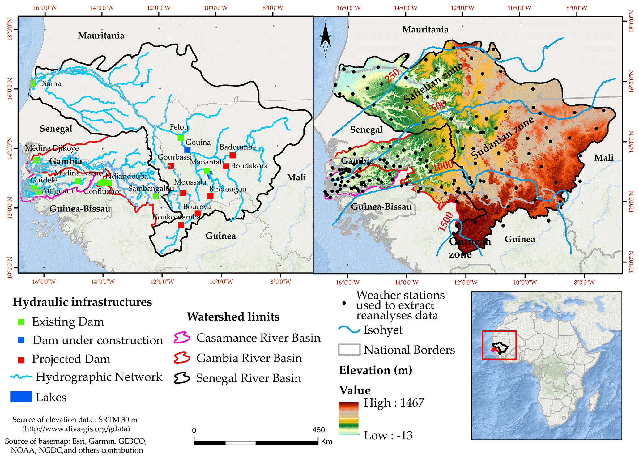
Figure 1Location of the three Senegalese hydrosystems, hydraulic infrastructures, climate zones, hydrographic network and weather stations used to extract reanalyses data.
2.2 Data
In West Africa, meteorological data managed by national meteorological services are difficult to access due to their high acquisition costs (Bodian et al., 2020). Additionally, the low density of the observation networks limits their spatial representativeness at the scale of the catchment area (Ndiaye et al., 2020). For this reason, reanalyses from the NASA Langley Research Center (LaRC) POWER Project funded through the NASA Earth Science/Applied Science Program (https://power.larc.nasa.gov, last access: February 2022) are used as an alternative (Ndiaye et al., 2020). The coordinates of 160 (64, 58 and 38 for Senegal, Gambia and Casamance river basins, respectively) stations distributed across the three basins (Fig. 1) are used to extract climate variables on a daily scale over the period 1984–2019. The climatic variables collected are: maximum and minimum air temperatures, solar radiation, air relative humidity and wind speed at 2 m above ground.
2.3 Methods
2.3.1 Estimation method of reference evapotranspiration
The reference method used is that of FAO56-PM which is given by the following formula:
Where is the reference evapotranspiration (mm d−1), Rn: net radiation on the crop surface (MJ m−2 d−1), G is the heat flux density of the soil (MJ m−2 d−1) which is ignored on a daily scale, T is the average daily air temperature at a height of 2 m (°C), Cn and Cd are constant values which change according to the scale of time used (on a daily scale Cn and Cd are 900 and 0.34 respectively), u2 is the wind speed at a height of 2 m (m s−1), es is the saturated vapor pressure (kPa) , ea is real vapor pressure (kPa), (es-ea) is the saturation deficit (in kPa) Δ is the vapor pressure slope curve (kPa °C−1) and γ is the psychrometric constant psychometric (kPa °C−1).
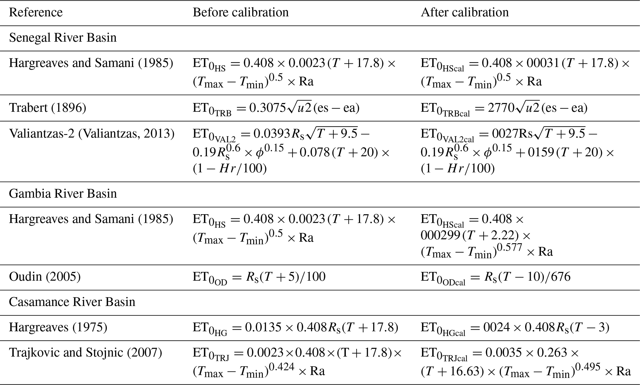
Table 1List of the twenty alternative methods evaluated against FAO56-PM.
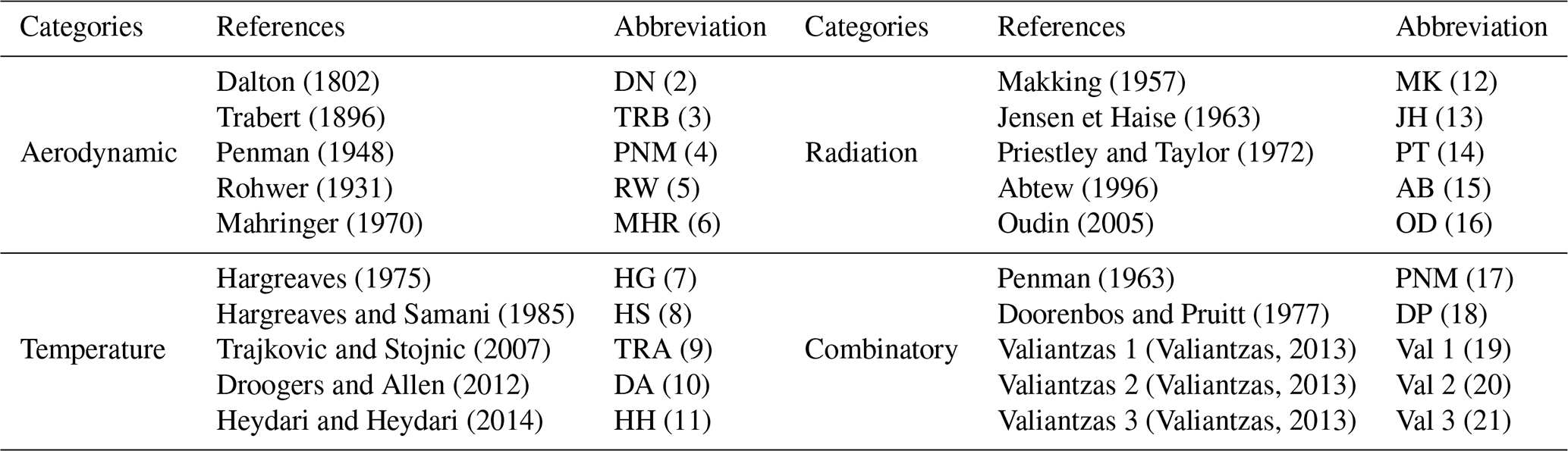
The list of the twenty alternative methods used in this work as well as their mathematical formulations are detailed in Ndiaye et al. (2020). The Table 1 give only the names of methods used and their categories.
The calibration of the best methods was done by the gradient reduction method (Bogawski and Bednorz, 2014). This seeks to change the constant values of the original methods to minimize estimation errors. For this, the series is divided into two part as recommended by Xu and Singh (2001): of the series (1984–2005) for calibration and (2006–2019) for validation. The calibrated methods were re-evaluated using the same criteria as for the evaluation with different timeframe dataset.
2.3.2 Evaluation criteria
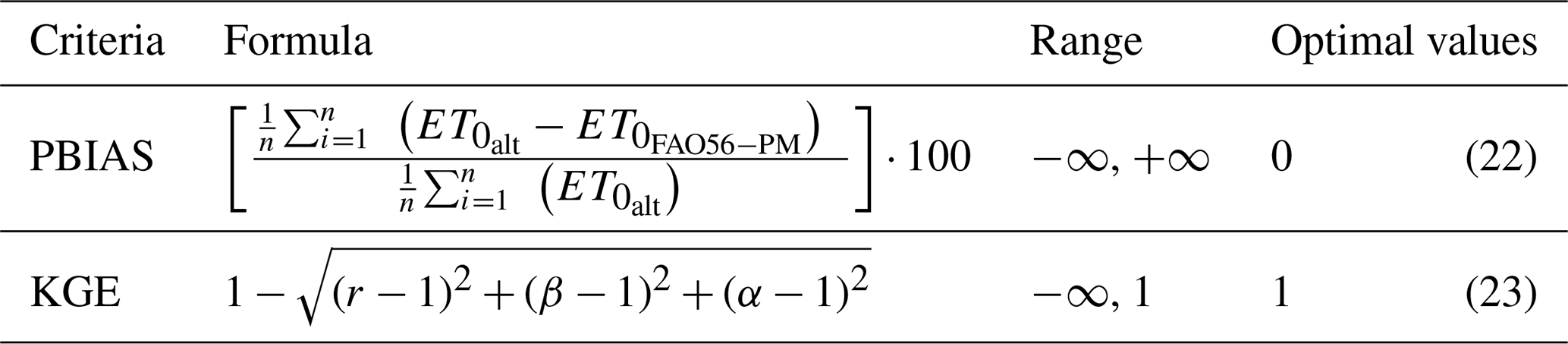
Kling Gupta Efficiency (KGE, Gupta et al., 2009) and percentage bias (PBIAS) are used (Table 2) to assess the performance of alternative methods. The KGE includes both the correlation coefficient (r), the biases (β) and the variability (γ) and makes it possible to determine the degree of concordance between the reference ET0 and that of the alternative methods. The PBIAS indicates errors as a percentage. A positive/negative PBIAS indicates an overestimation/underestimation of ET0 by the alternative method.
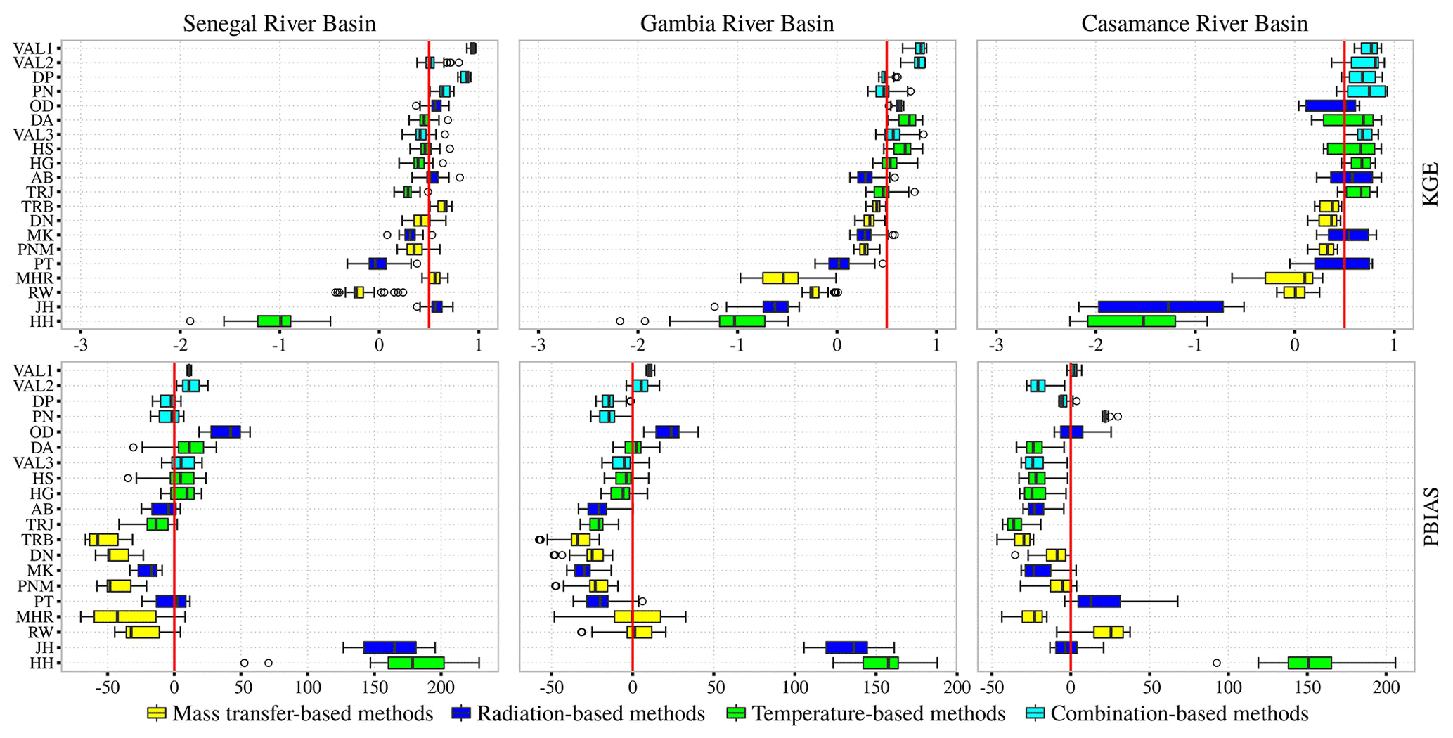
Figure 2Performance of the methods according to the KGE (The red line in each figure represents the mean values of each KGE).
3.1 Evaluation of twenty alternative methods against FAO56-PM
Figure 2 gives the synthesis of the KGE of the twenty alternative methods compared to the FAO56-PM (Penman–Monteith). Because of the objective of this work, only the results of methods integrating few climatic variables are presented. The performance of these methods varies slightly depending on the river basins. For the Senegal River basin, the five best methods are those of Trabert, Valiantzas 3, Jensen & Haise and Hagreaves & Samani. For the Gambia River basin, in addition to the methods of Valiantzas (2 and 3), those of Oudin, Droogers & Allen and Hargreaves & Samani are the most robust for estimating ET0. The KGE values of these methods are generally greater than 0.60 and estimation errors of −4 % to 23 %. In the Casamance River basin, the temperature-based methods of Hargreaves (HG) and Trajkovic give the best results with KGE of nearly 0.88 and low estimation errors ranging from −4.6 % to 11 %.
3.2 Calibration and validation of the best methods
The choice of methods to be calibrated is guided by the performance criteria and the number of climatic variables they include. On the basis of these criteria, five methods were selected in each basin for calibration. In the Senegal River basin, the mean KGE values of Trabert and Hargreaves & Samani methods increased globally by 24 % to 40 %. Trabert estimation errors were reduced by 97 % after calibration. In the Gambia River basin, the KGE values of the calibrated methods increased by 12 % to 28 %. The estimation errors of the VAL2 and DA methods decreased by 37 % and 23 %, respectively, after calibration in the basin. In the Casamance River basin, calibration slightly improved the performance of the methods. For example, the KGE values of the VAL2, HG and TRJ methods increased by 7 %, 5 % and 2 % respectively (Fig. 3 and Table 3). Figure 4 gives the spatial distribution of the PBIAS, which shows that the calibrated methods are effective in all the river basins. The Trabert method overestimates ET0 over almost the entire Senegal River basin while the combinatory (VAL2, VAL3), radiation-based (Oudin) and temperature-based (Hargreaves) methods underestimate it in the Gambia basin. In the Casamance River basin, ET0 is overestimated on the coastal fringe and underestimated on the mainland. Given the similarity of certain results and based on the number of climatic variables, the best methods retained in this study are summarized in Table 2. Thus, the calibration has improved the performance of the methods for estimating ET0 in the three basins. The performance of these methods was noted by Ndiaye et al. (2020) in the Senegal River Basin and Djaman et al. (2015) in the Senegal River Valley and Delta.
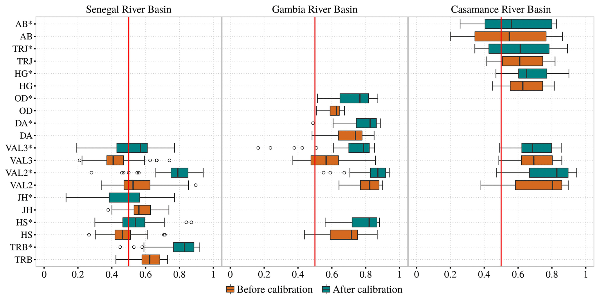
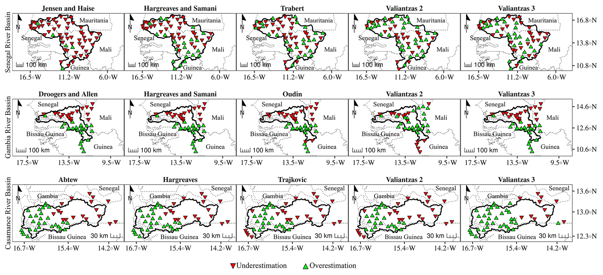
Figure 4Spatial repartition of PBIAS according to calibrating methods.
This study provides information on the choice of simple methods for estimating reference evapotranspiration in the main hydrosystems of Senegal. The results show that the Trabert method can be used in the Senegal River basin when temperature and wind speed data are available. The Valiantzas 2 method is applicable to all three basins. For the Gambia and Casamance river basins, temperature-based (Hargreaves, Hargreaves & Samani and Trajkovic) and radiation-based (Oudin) methods can be used when only temperature or solar radiation data is available. This information can be useful for water managers and irrigation development. However, the reanalyses data used can constitute a limit of this work.
The software R used in this study is freely available (https://www.r-project.org/, last access: February 2022; R Development Team, 2022). The code is not publicly accessible. Please contact the authors if you are interested in this research code.
The data of climate variables used in this study are available for public. They come from NASA Langley Research Center (LaRC) POWER Project funded through the NASA Earth Science/Applied Science Program (https://power.larc.nasa.gov/data-access-viewer/, last access: February 2022; NASA, 2022). Please contact the authors if you are interested in the evapotranspiration data used in this research.
Conceptualization, methodology,
software and writing: AB, PMN, SBD. Review, editing and proofreading: AD, LD, AO, and KD. All authors have read and agreed to the published version of the manuscript.
The contact author has declared that none of the authors has any competing interests.
Publisher's note: Copernicus Publications remains neutral with regard to jurisdictional claims in published maps and institutional affiliations.
This article is part of the special issue “IAHS2022 – Hydrological sciences in the Anthropocene: Variability and change across space, time, extremes, and interfaces”. It is a result of the XIth Scientific Assembly of the International Association of Hydrological Sciences (IAHS 2022), Montpellier, France, 29 May–3 June 2022.
The authors would like to thank ActNAO for funding Bassirou Diop's Master's work, the results of which are presented in this document. They are also grateful to SYSTA for according the travel grant to Papa Malick Ndiaye to participate in the 11th Scientific Assembly of the IAHS from 29 May to 5 June 2022 in Montpellier, France.
This paper was edited by Christophe Cudennec and reviewed by Abdoulaye Faty and one anonymous referee.
Abtew, W.: Evapotranspiration measurement and modeling for three wetland systems in South Florida, Water Resour. B., 32, 465–473, 1996.
Bodian, A., Diop, L., Panthou, G., Dacosta, H., Deme, A., Dezetter, A., Ndiaye, P. M., Diouf, I., and Vichel, Th.: Recent Trend in Hydroclimatic Conditions in the Senegal River Basin, Water, 12, 436, https://doi.org/10.3390/w12020436, 2020.
Bogawski, P. and Bednorz, E.: Comparison and validation of selected evapotranspiration models for conditions in Poland (Central Europe), Water Resour. Manag., 28, 5021–5038, https://doi.org/10.1007/s11269-014-0787-8, 2014.
Dacosta, H.: Précipitations et écoulements sur le bassin de la Casamance. Dakar: ORSTOM, 278 p. multigr. Th. 3e cycle: Géogr. Phys., Hydrologie, Université Cheikh Anta Diop: Dakar, 1989.
Dalton, J.: Experimental essays on the constitution of mixed gases; on the force of steam of vapor from waters and other liquids in different temperatures, both in a Torricellian vacuum and in air on evaporation and on the expansion of gases by heat, Memoirs of the Manchester Literary and Philosophical Society, 5, 535–602, 1802.
Djaman, K., Balde, A. B., Sow, A., Muller, B., Irmak, S., Ndiaye, M. K., and Saito, K.: Evaluation of sixteen reference evapotranspiration methods under sahelian conditions in Senegal River Valley, J. Hydrol. Reg. Stud., 3, 139–159, https://doi.org/10.1016/j.ejrh.2015.02.002, 2015.
Doorenbos, J. and Pruitt, W. O.: Guidelines for Predicting Crop Water Requirements, FAO Irrigation and Drainag, Paper No. 24, FAO, Rome, Italy, 1977.
Droogers, P. and Allen, R. G.: Estimating Reference Evapotranspiration under Inaccurate Data Conditions, Irrig. Drain. Syst., 16, 33–45, https://doi.org/10.1023/A:1015508322413, 2002.
Gupta, H. V. K., Yilmaz, G. K. K., and Martinez, G. F.: Decomposition of the mean squared error and NSE performance criteria: Implications for improving hydrological modeling, J. Hydrol., 377, 80–91, 2009.
Hargreaves, G. H.: Moisture availability and crop production. Transactions of the ASAE, 18, 980–984, 1975.
Hargreaves, G. H. and Samani, Z. A.: Reference Crop Evapotranspiration from Temperature, Am. Soc. Agric. Eng., 1, 96–99, 1985
Heydari, M. M. and Heydari, M.: Evaluation of Pan Coefficient Equations for Estimating Reference Crop Evapotranspiration in the Arid Region, Archives of Agronomy and Soil Science, 60, 715–731, https://doi.org/10.1080/03650340.2013.830286, 2014.
Jensen, M. E. and Haise, H. R.: Estimating evapotranspiration from solar radiation, J. Irrig. Drain. Div., 89, 15–41, 1963.
Mahringer, W.: Verdunstungsstudien and Neusiedler See, Archiv für Meteorologie Geophysik und Bioklimatologie, série B, 18, 1–20, 1970.
Makking, G. F.: Testing the Penman formula by means of lysimeters, J. Inst. Water Eng., 11, 277–288, 1957.
Monteith, J. L.: Evaporation and Environment. 19th Symposia of the Society for Experimental Biology, University Press, Cambridge, 19, 205–234, 1965.
NASA: POWER Data Access Viewer, NASA [data set], https://power.larc.nasa.gov/data-access-viewer/, last access: February 2022, 2022.
Ndiaye, P. M., Bodian, A., Diop, L., Deme, A., Dezetter, A., and Djaman, K.: Evaluation and Calibration of Alternative Methods for Estimating Reference Evapotranspiration in the Senegal River Basin, Hydrology, 7, 24, https://doi.org/10.3390/hydrology7020024, 2020.
Oudin, L.: Recherche d'un Modèle D'évapotranspiration Potentielle Pertinent Comme Entrée d’un Modèle Pluie-Débit Global (Search for a Relevant Potential Evapotranspiration Model as Input for a Global RainFlow Model), PhD Thesis, L'école National de Génie Rural, des Eaux et Des Forêts (ENGREF), 2005, Paris, France, 496 pp., https://pastel.archivesouvertes.fr/file/index/docid/499816/filename/memoire.pdf (last access: March 2022), 2005 (in French).
Penman, H. L.: Natural evaporation from open water, bare soil and grass, P. Roy. Meteorol. Soc., 193, 120–145, 1948.
Penman, H. L.: Vegetation and hydrology, Tech. Comm. No. 53, Commonwealth Bureau of Soils, Harpenden, England, 125 pp., 1963.
Priestley, C. H. B. and Taylor, R. J.: On the assessment of surface heat flux and evaporation using large scale parameters, Mon. Weather Rev., 100, 81–92, 1972.
R Development Team: The R Project for Statistical Computing, R Development Team [software], https://www.r-project.org/, last access: February 2022.
Rohwer, C.: Evaporation from Free Water Surfaces, Technical Bulletin, 271, US Department of Agriculture, Washington DC, 1931.
Trabert, W.: Neue beobachtungen über verdampfungsgeschwindigkeiten, Meteorol. Z., 13, 261–263, 1896.
Trajkovic, S. and Stojvic, V.: Effect of wind speed on accuracy of Turc method in humid climate, Architecture and civil engineering, 5, 107–113, 2007.
Valiantzas, J.: Simple ET0 of Penman's Equation without wind/or Humidity Data. II: Comparisons Reduced Set-FAO and other methodologies, Am. Soc. Civ. Eng., 139, 9–19, https://doi.org/10.1061/(ASCE)IR.19434774.0000502, 2013.
Valipour, M.: Calibration of mass transfer-based methods to predict reference crop evapotranspiration, Application Water Science, 1, 1–11, 2015.
Xu, C. Y. and Singh, V. P.: Evaluation and generalization of temperature-based methods for calculating evaporation, Hydrol. Process., 14, 305–319, 2001.