the Creative Commons Attribution 4.0 License.
the Creative Commons Attribution 4.0 License.
 | 19 Apr 2024
Impacts of climate variations and human influences on groundwater recharge in the semi-arid Trarza aquifer (SW Mauritania)
Ahmed Salem Mohamed
Christian Leduc
Sidi Yeslem
Guinka Tagarinska
Salek Aichete
Hydrological processes are rapidly changing in semi-arid areas under the double constraint of climate change and anthropization. Such changes were investigated at different scales of time and space in the Trarza aquifer (SW Mauritania), a flat region of about 40 000 km2 with a low rainfall (100 to 250 mm a−1). All old sources of hydrogeological information were exploited in complement with the more recent surveys. The geochemical information shows the importance of Quaternary eustatic variations in the present groundwater mineralization. In spite of very great variations of rainfall, the piezometric stability over the last 50 years shows that infiltration (about 4 mm a−1) did not vary significantly. Since 1989, the big Diama dam has raised the mean level of the Senegal River, which brings an additional inflow to the alluvium and to the Trarza aquifer (about 34 hm3 a−1). Groundwater recharge from the river and rainfall infiltration over the whole area have the same order of magnitude. In the Nouakchott area, the new supply of water to the capital (45 hm3 a−1) has led to a significant groundwater rise and the submersion of several urban districts.
- Article
(1539 KB) - Full-text XML
- BibTeX
- EndNote


UPH3; UPH13; Panta Rhei; Field observation; Mauritania; Groundwater recharge; Surface-groundwater interaction; Temporal changes
The climate change is often evoked as a major threat on water resources in the next decades, especially in semi-arid areas. In fact, most of these regions are already exposed to multiple human activities that deeply modify the water cycle and these changes undermine the fragile balance between resources and uses that has existed for centuries (e.g. Scanlon et al., 2006; Leduc et al., 2017).
In Africa, the Sahelian region was marked by the catastrophic droughts of the 1970s and 1980s (e.g. Balme et al., 2006). In contrast with this violent phenomenon, the ever increasing demographic pressure and its heavy consequences on land use and land cover is an even more important driver of change, but it has acted continuously and progressively over the long term (e.g. Leblanc et al., 2008). In the same time, the multiplication of large and small hydraulic works, linked to the development of irrigation and the greater control of floods, modifies the flow and storage of both surface water and groundwater. Research on the evolution of water resources must therefore be carried out at multiple spatial and temporal scales. In the Sahel, wide areas with little infrastructure, a small amount of heterogeneous and sparse data do not represent the most favourable context. The Trarza aquifer in south-western Mauritania is emblematic of these difficulties where multiple influences must be unravelled among anthropization and climatic fluctuations of the last few decades, but also older paleo-environmental changes. These different drivers have considerably impacted the groundwater quantity and quality. The analysis of all the available data, recent and old, shows that beyond the apparent regional stability of the water table, water flows have changed considerably since 50 years.
The Trarza region extends over 40 000 km2 in SW Mauritania and is limited by the Senegal River, the Atlantic Ocean and the Mauritanides metamorphic range (Fig. 1). In this very flat region, the succession of Quaternary dunes and interdune depressions is the main relief figure. The short rainy season (June to September) and the long dry season are typical of the Sahelian climate, as well as the S-N rainfall gradient (about 250 mm a−1 in the Senegal River valley and only 100 mm a−1 in Nouakchott). Like everywhere in semi-arid areas, rainfall is very irregular in space and over time: the annual average may fall in one or two rainy events (as in the case of Rosso in 2010) and, at another scale of time, the whole Sahelian region was marked by a long and severe drought in the 1970s and 1980s. The phreatic aquifer is the highest in a multi-layered aquifer system of the Senegal-Mauritania sedimentary basin. Its Tertiary and Quaternary sediments are alternating lacustrine, eolian and marine deposits. The rural population is less than 300 000 inhabitants, to be compared with more one million people living now in Nouakchott, the capital city that was created from nearly nothing at the end of the 1950s. Until 2011, the water supply for Nouakchott was taken from the Trarza aquifer by pumping in the Idini area. Water for the city is now transferred from the Senegal River by a 180 km pipe.

Figure 1Extent of the Trarza phreatic aquifer and its piezometric contour lines drawn from the 2010–2020 survey.
The mean depth to the water table is about 30 m, but it varies between a few metres close to the sea and the Senegal River and more than 70 m in the north-eastern part. The thickness of the saturated zone varies between 10 and 50 m, with a mean of 20 m. The volume of water stored in the aquifer is estimated at 100 km3.
All available hydrogeological data since the first measurements in 1959 were collected and exploited. This data set is very heterogeneous, with a few big campaigns like in 1959 (Paloc, 1962), 1973 (unpublished) and 2011 (unpublished), and many sparse and discontinuous point observations. In a few sites, a specific survey provides a much denser information in space and/or over time. The richest example is the Idini area where the national water company SNDE has accumulated about 1000 measurements since 1972 in the 30 km2 of the pumping site.
These different measurements consist mostly of groundwater levels and, secondarily, electrical conductivity of groundwater. Analyses of major ions and isotopes and estimations of hydrodynamic characteristics are much rarer.
In spite of its heterogeneity, this data set enables the differentiation of the multiple drivers acting on the Trarza phreatic aquifer at various scales in space and over time, from the local pumping to the climatic variations and marine transgressions of the Quaternary.
4.1 Long-term regional stability
The comparison of measurements over 60 years requires that wells are indisputably identified and not exposed to significant perturbations like a local pumping or a distant big hydraulic work. Depending on the data subsets that are compared, the number of common points varies between 13 and 97. The main result is the absence of a clear trend over decades. For instance, in the most copious comparison (1973 vs. 2011), rising wells are as numerous as decreasing wells and their geographical distribution has no visible pattern. This overall stability is a significant help: isolated measurements can be used for complementing the major field campaigns and their merging provides a very robust piezometric map (Fig. 1).
4.2 Rainfall infiltration in the interdune depressions
After clearing of possible disturbances by local pumping, a seasonal fluctuation of the groundwater level is frequently observed in interdune depressions during the rainy season (between 0.2 and 1 m in most cases).The continuous measurement in the Nkek village (Fig. 2) illustrates the phenomenon, in complete coherence with other continuous observations and measurements taken before and after the rainy season in 36 wells in 2010 and 49 wells in 2015.
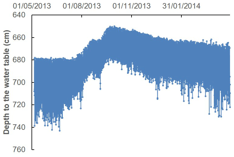
Figure 2Fluctuation of the groundwater level in a well at the foot of a dune: seasonal recharge by rain infiltration and daily perturbation by pumping.
In spite of the low annual rainfall, this recharge seems present over the whole aquifer. Nine measurements of 14C (Mohamed, 2012) and 17 measurements of 3H (IAEA, 2011, 2017) revealed highly variable mixing of recent and older waters (0–6 TU; 0–9 ka) and confirmed the existence of a modern contribution everywhere in the aquifer.
Using the water table fluctuation method (WTF) and assuming an effective porosity of 8 %, the median value of recharge was estimated at 1.5 % of the total rainfall in the north of the study area, and 2.1 % in the south, which represents a regional recharge by rainfall of about 4 mm a−1.
4.3 Recharge from the Senegal River
In the whole Trarza region, the highest groundwater levels are met along the Senegal River. Before the construction of the Diama dam, at 23 km from the river mouth, and the Manantali dam, in Mali, at the end of the 1980s, the annual flood of the river was very variable in duration and amplitude. Exchanges between the river and alluvium reversed seasonally (Illy, 1973). In the low flow period, sea water could reach 250 km up the valley, which obviously impacted the groundwater quality. Since the construction of the two dams, the river level is kept much higher (in Rosso, the minimum river level has risen by 2 m). The river control induces a permanent recharge to the Trarza phreatic aquifer, and the rise of groundwater levels on both banks of the river is up to 1 m (Mohamed et al., 2014; Ngom et al., 2016). This recharge flow is estimated at about 110 hm3 a−1, a hydraulic gradient of 1 ‰ and a median transmissivity of 5.5 × 10⁻³ m2 s−1 in the neighbouring aquifer. Uncertainty is still large but independent calculations in surface water and groundwater converge.
4.4 Urban recharge in Nouakchott
In its natural state, groundwater of the Nouakchott area was naturally brackish and not used for human consumption. It was, and still is, very close to the ground surface and hydraulically constrained by the sea and the strong evaporation uptake. Population in the capital city changed from 5000 inhabitants in 1960 to more than one million. Most of domestic waste water is discharged in individual septic tanks and recharges the phreatic aquifer. Since 2011, the water supply provided from the Senegal River has tripled the quantity of water distributed in the capital (about 0.12 hm3 d−1 presently). Increased leaks from the water distribution network and increased waste water release have increased the aquifer recharge and the water table has risen by up to 0.6 m (Mohamed et al., 2017). Large urban districts are now submerged and the phenomenon is limited only by a constant pumping in multiple sites of the city (Fig. 3).
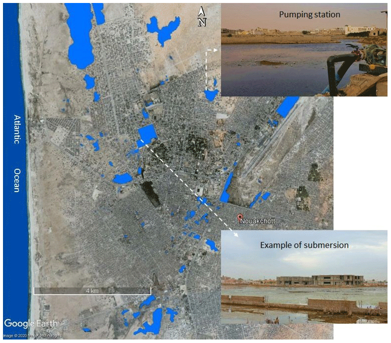
Figure 3Areas submerged by the groundwater rise in Nouakchott in light blue (background © Google Earth).
4.5 Intense pumping in Idini
After 40 years of progressive increase of pumping, the maximum drawdown observed in the piezometers spread over the 30 km2 of the Idini pumping site was 7.7 m. Because of the strong reduction in pumping since 2011, the groundwater level has partially recovered (up to 3 m). The volume of dewatered aquifer was about 16 hm3 in 2011, which is very small in comparison with the total of pumped volumes over four decades (0.4 km3). This limited drawdown is consistent with the local hydrodynamic characteristics (median transmissivity of 5.5 × 10⁻³ m2 s−1).
Whatever the pumping rate, there has been no overall degradation of the groundwater quality in Idini over time. Only three boreholes among the 46 wells in operation have experienced a significant change in mineralization since 1972 (from 300 to 1210 mg L−1 for the most important variation) while in all others, no fluctuations exceeded 10 % in 50 years.
5.1 Regional groundwater flows
The uneven distribution of information, with a smaller density in the north and east of the Trarza aquifer, is a difficulty but not an obstacle to the understanding of regional hydrogeology.
The highest groundwater levels are observed close to the coast and in the Senegal River valley, and the water table progressively decreases to the northeast. This reminds the natural piezometric closed depressions that are frequently observed in the Sahelian region (e.g. Favreau et al., 2002). The singularity of a dissymmetrical shape can be explained by the contact with the impervious metamorphic Mauritanides rocks.
5.2 Long-term stability and recharge
Like all other Sahelian regions, Trarza was subject to the very severe droughts of the 1970s and 1980s and to rapid demographic changes but, surprisingly, there is no obvious trace of these major events in groundwater while many other Sahelian aquifers experimented important changes (e.g. Leduc et al., 2001). The stability of the water table over 60 years is an indicator of a low renewal rate. Out of the Nouakchott area, recharge is due to rainfall infiltration and inflow from the Senegal River, estimated at about 0.16 and 0.11 km3a−1 respectively. Even if uncertainty remains large on the two figures, the order of magnitude is certain. Their sum is less than 3 ‰ of the water stored in the Trarza aquifer, which is coherent with the small impact of recent events. The net recharge is probably even smaller than 3 ‰ as a significant part of this inflow may go back to the atmosphere by evapotranspiration in the first months after infiltration.
The low value of rain infiltration, between 1 % and 5 % of annual rainfall, agrees with other estimates of recharge in semi-arid areas. Under the natural conditions that previously existed in south-western Niger, Le Gal La Salle et al. (2001) proposed a value of 5 mm a−1 (i.e., 1 % of annual rainfall of about 560 mm). The same ratio was also calculated by Leduc et al. (2000) in the drier north-western Lake Chad basin. Beyond the Sahelian belt, the proposed value also agrees with the wide compilation of studies in semi-arid regions by Scanlon et al. (2006), who concluded that recharge usually varies between 0.1 % and 5 % of annual rainfall.
A first independent confirmation of the low renewal rate comes from the stability of the piezometric closed depression. In continental areas, the only acceptable explanation for such shapes is evapotranspiration uptake, which is necessarily very low when groundwater lies at some tens of metres below the ground surface. An important recharge would rapidly erase the depression.
Another confirmation comes from the presence of seawater in the aquifer, at tens of kilometres of the present coastline (Mohamed et al., 2014). These relicts of the last transgression episodes of Quaternary would have disappeared by dilution in case of an important annual recharge.
5.3 Groundwater memory
Transgression episodes have been essential drivers of groundwater dynamics in the past (Elouard et al., 1972; Miskovsky et al., 1991). They covered a very large extent and lasted a long time and their impact is still visible locally in the aquifer mineralization (high salinity, Br Cl ratio close to the marine ratio), even very far from the present coastline (Fig. 4). Traces of more local and/or shorter hydrological events of the past are identified with greater difficulty.
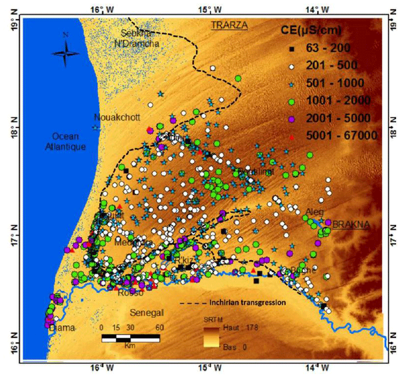
Figure 4Groundwater salinity in the Trarza aquifer (Mohamed, 2012; complemented with the data set of the present study). The black dashed line limits the maximum of Quaternary transgressions.
In 1950, an exceptional flood of the Senegal River spread floodwater throughout the Aftout es Sahili, a long topographic depression parallel to the coastline, at a distance of 1 to 3 km from the sea. It brought water from the Senegal River right up to Nouakchott, 190 km north of the river delta. There was no hydrogeological measurements at that time but the presence of modern fresh water in the coastal brackish groundwater is a good indicator of an exceptional recharge (Mohamed, 2012). This fresh water may result from the 1950 flood only or from the accumulation of several similar older floods that occurred a very few times per century. Their impact was limited to a narrow coastal strip but the amount of water entering the aquifer may have been as important locally as the rain infiltration for 30 or 50 years.
Further into the past, the bed of the Senegal River has moved significantly over time. A former river bed is still visible farther north in Mauritania in the form of Lake Aleg and Lake R'kiz, then farther south in Senegal with Lake Guiers (Fig. 1). The maximum distance to the north from the present bed is about 70 km. Each year Lake R'kiz is filled up by a distributary of the Senegal River, which follows the ancient bed and recharges the surrounding aquifer with a preferential flow along the former bed.
The long history of the Trarza aquifer implies that the contemporary observations have to be interpreted in connection with present drivers and also in reference to much older events.
5.4 Anthropogenic perturbations in Nouakchott
Increasing groundwater recharge in Nouakchott obviously has considerable social, sanitary and geotechnical consequences. The process started 10 years ago and will probably continue over the next decades. Even partially polluted by domestic uses, this artificial recharge will gradually reduce the groundwater salinity, which was originally very high in this area.
As a counterpoint to the geochemical improvement, this artificial recharge is compensated by a permanent pumping to limit the extension of flooded areas. Part of this water is discharged into the sea, the rest is discharged over the ground surface away from the city, which only shifts the problem. In this very flat city, partly below sea level and with a very insufficient wastewater collection system, a more sustainable alternative is still to be found.
Another important issue in the Nouakchott area is the weakening of the coastal dune bar by uncontrolled sand extraction and by harbour dykes modifying the littoral sediment transport (Mohamed et al., 2017). The rise of the sea level and the increased number of storms expected as a consequence of the global warming will lead to more frequent intrusion of seawater in the coastal area. The same threat concerns two other sites of new big harbours along the Mauritanian coast.
5.5 Anthropogenic perturbations in the Senegal River valley
Thirty years after Diama dam was built, groundwater can be considered as having reached a new equilibrium with the raised base level of the river. Our present estimate of annual inflow from the Senegal River of about 110 hm3 is a net recharge to the Trarza aquifer, lower than the total sum of fluxes exchanged each year in both directions during the annual flood and the following recession. It is consistent with the hydrological surveys of the Senegal River (e.g. Dieng, 1999). In the most recent synthesis, Bader (2015) estimated the river loss between Bakel (630 km upstream of Diama) and Diama at a mean value of 725 hm3 a−1, to be divided into direct evaporation, evapotranspiration in the riparian vegetation and groundwater recharge through the two banks.
The Senegal delta area downstream of Diama is very fragile hydraulically and sedimentarily, depending on oceanic and continental conditions (e.g. Barusseau et al., 1998) and human interventions could significantly impact it. A dramatic example is the artificial breach that was opened in October 2003 in the Langue de Barbarie, which is a narrow strip of land between the Senegal River and the Atlantic Ocean, downstream of Diama. The breach was dug to prevent a disastrous flood of the Senegal River, with an initial width of a few metres that rapidly reached 5 km and changed the freshwater-salt water balance in the whole area. In a less violent evolution, irrigation expands along the Senegal valley (34 700 ha in 2015) and will even increase with the construction of a new canal to the Aftout es Sahili coastal depression, transferring water from the Senegal River (55 km northwards) to a new 16 000 ha irrigated area. These new hydraulic conditions will progressively modify both the level and quality of groundwater, northwards and eastwards respectively, as already observed ion the southern bank of the Senegal River (e.g. Diaw et al., 2019).
Like many other semi-arid areas, South-west Mauritania depends on groundwater for supplying water to rural communities, but hydrogeological information is still scarce. This may be easily explained by the size of the country, the small and poor population, and the sparse hydraulic infrastructure. The lack of any information before the 1950s and the limited amount of data acquired since could limit the identification of major physical processes. In fact, the large extent of the aquifer and the small renewal rate give it a great inertia, which makes possible to concatenate heterogeneous data sets. This inertia allows scientists to go back into the past and find traces of exceptional events that took place a few decades, centuries or thousands of years ago.
In contrast with many other semi-arid aquifers, the Trarza aquifer does not appear exposed to high risks in the near future. In quantitative terms, the water supply to Nouakchott from the Senegal River has considerably reduced the volume of water pumped from the aquifer and the higher river level in the Senegal River has increased the recharge from the river. In qualitative terms, the control of the Senegal River now avoids the marine intrusion that used to come up every year and brings an additional input of freshwater to the aquifer. At the local scale of Nouakchott, the massive introduction of fresh water in the aquifer reduces the groundwater salinity.
Numerous decisions concerning water management in Mauritania are now taken without a clear idea of the hydrological context and their possible consequences. The relative groundwater inertia and the absence of an immediate big threat cannot justify that observation networks are not seen as a necessity by authorities while they undertake new large-scale hydraulic infrastructures.
Older data were exploited from numerous original technical reports, mostly unpublished. Data are not freely available but may be requested from the first author.
The paper was mostly written by ASM and CL. All authors contributed to the collection and interpretation of recent data.
The contact author has declared that none of the authors has any competing interests.
Publisher’s note: Copernicus Publications remains neutral with regard to jurisdictional claims in published maps and institutional affiliations.
This article is part of the special issue “IAHS2022 – Hydrological sciences in the Anthropocene: Variability and change across space, time, extremes, and interfaces”. It is a result of the XIth Scientific Assembly of the International Association of Hydrological Sciences (IAHS 2022), Montpellier, France, 29 May–3 June 2022.
This paper was edited by Christophe Cudennec and reviewed by Mohammad Merheb and one anonymous referee.
Bader, J. C.: Monographie hydrologique du fleuve Sénégal. De l'origine des mesures jusqu'à 2011, IRD Editions, ISBN 978-2-7099-1885-5, 2015.
Balme, M., Lebel, T., and Amani, A.: Années sèches et années humides au Sahel: quo vadimus?, Hydrol. Sci. J., 51, 254–271, 2006.
Barusseau, J. P., Ba, M., Descamps, C., Diop, E. S., Diouf, B., Kane, A., Saos, J. L., and Soumaré, A.: Morphological and sedimentological changes in the Senegal River estuary after the construction of the Diama dam, J. Afr. Earth Sci., 2, 317–326, 1998.
Diaw, M., Mall, I., Leblanc, M., Faye, S., and Travi, Y.: Quantitative estimation of recharge potentialities of shallow aquifers in Senegal River Delta hydrosystem, American J. Water Sci. Engineering, 5, 47–61, 2019.
Dieng, B.: Impacts des barrages de Diama et Manantali sur les nappes de la vallée du fleuve Sénégal. Sud Sci. Technologies. 3, 31–38, 1999.
Elouard, P., Faure, H., and Hébrard, L.: Quaternaire du littoral mauritanien entre Nouakchott et Port-Etienne (18°–21° latitude Nord), ASEQUA, 23, 15–24, 1972.
Favreau G., Leduc, C., Marlin, C., and Guero, A.: Une dépression piézométrique naturelle en hausse au Sahel (Sud-Ouest du Niger), C.R. Geosci., 334, 395–401, 2002.
IAEA (International Atomic Energy Agency): Studies on groundwater in Mauritania, Water & Environment news no. 28, IAEA, Vienna, Austria, ISSN 1020-7120, 2011.
IAEA (International Atomic Energy Agency): Integrated and sustainable management of shared aquifer systems and basins of the Sahel Region, The Senegalo-Mauritanian basin. Report of the RAF/7/011 project, Vienna, Austria, 43 pp., https://www.iaea.org/sites/default/files/raf7011_senegalo-mauritanian_basin.pdf (last access: 1 July 2023), 2017.
Illy, P.: Etude hydrogéologique de la vallée du fleuve Sénégal, Technical report for “Projet hydro-agricole du bassin du fleuve Sénégal”, OMVS technical report, Dakar, Senegal, 163 pp., 1973.
Leblanc, M. J., Favreau, G., Massuel, S., Tweed, S. O., Loireau, M., and Cappelaere, B.: Land clearance and hydrological change in the Sahel: SW Niger, Global Planet. Change, 61, 135–150, 2008.
Leduc, C., Sabljak, S., Taupin, J. D., Marlin, C., and Favreau, G.: Estimation de la recharge de la nappe quaternaire dans le Nord-Ouest du bassin du lac Tchad (Niger oriental) à partir de mesures isotopiques, C.R. Acad. Sci. Paris, 330, 355–361, 2000.
Leduc, C., Favreau, G., and Schroeter, P.: Long-term rise in a Sahelian water-table: the Continental Terminal in South-West Niger, J. Hydrol., 243, 43–54, 2001.
Leduc, C., Pulido-Bosch, A., and Remini, B.: Anthropization of groundwater resources in the Mediterranean region: processes and challenges, Hydrogeol. J., 25, 1529–1547, 2017.
Le Gal La Salle, C., Marlin, C., Leduc, C., Taupin, J. D., Massault, M., and Favreau, G.: Renewal rate estimation of groundwater based on radioactive tracers (3H, 14C) in an unconfined aquifer in a semi-arid area, Iullemeden Basin, Niger, J. Hydrol., 254, 145–156, 2001.
Miskovsky, J. C., Saos, J. L., and Bonkel, A.: Paléohydrologie et paléoclimatologie des bassins endoréiques du sud de la Mauritanie depuis 18 000 B.P., Bull. Soc. Géol. France, 162, 1141–1150, 1991.
Mohamed, A. S.: Approches hydrodynamique et géochimique de la recharge de la nappe du Trarza (SO de la Mauritanie), PhD thesis, University Paris-Sud 11, France, https://theses.hal.science/tel-00800604 (last access: 1 July 2023), 2012.
Mohamed, A. S., Marlin, C., Leduc, C., and Jiddou, M.: Means of groundwater recharge in a semi-arid area: example of the Trarza aquifer (southwest Mauritania), Hydrol. Sci. J., 59, 1046–1062, 2014.
Mohamed, A. S., Leduc, C., Marlin, C., Wagué, O., and Sidi Cheikh, M. A.: Impacts of climate change and anthropization on groundwater resources in the Nouakchott urban area (coastal Mauritania), C.R. Geosci., 349, 280–289, 2017.
Ngom, F. D., Tweed, S., Bader, J. C., Saos, J. L., Malou, R., Leduc, C., and Leblanc, M.: Rapid evolution of water resources in the Senegal delta, Global Planet. Change, 144, 34–47, 2016.
Paloc, H.: Carte hydrogéologique du bassin sud-ouest mauritanien au 1 / 500 000 et notice explicative d'après les travaux d'Elouard P. (1959), Technical report, BRGM, Dakar, 1962.
Scanlon, B. R., Keese, K. E., Flint, A. L., Flint, L. E., Gaye, C. B., Edmunds, W. M., and Simmers, I.: Global synthesis of groundwater recharge in semiarid and arid regions, Hydrol. Process., 20, 3335–3370, 2006.