the Creative Commons Attribution 4.0 License.
the Creative Commons Attribution 4.0 License.
Using radiotracers 137Cs and 210Pbex to document climate change in mountain areas through the estimate of soil erosion rates
During the last few decades, a general increase in heavy rainfall events has been documented in many areas of the world. These events have caused changes in soil erosion rates and strongly affected the human activities in mountain areas by reducing the national income obtained from cultivated land. In this context, the use of fallout radiotracers can be an important tool for better understanding the consequences of climate change in these areas and proposing effective countermeasures in order to reduce soil loss. In this contribution, plot experiments carried out in southern Italy that involve the use of 137Cs and 210Pbex measurements were performed to estimate soil erosion rates during the last few decades. The overall results indicate an increase in soil erosion rates during the last 15–20 years and suggest the use of this technique to detect climate change in mountain areas.
- Article
(2129 KB) - Full-text XML
- BibTeX
- EndNote
The global fallout of the artificial radionuclide caesium-137 (137Cs; half-life of ca. 30.2 years), associated with the testing of nuclear weapons performed during the period 1954–1980, has now been successfully used as the basis for estimating soil erosion rates in many areas of the world (IAEA, 2014; Ritchie and Ritchie, 2005). Important advantages of the approach include, firstly, the potential to obtain retrospective information on soil erosion rates on the basis of a single site visit; secondly, the spatially distributed nature of the data generated; and, thirdly, the ability to collect data from the “natural” landscape without the need to establish long-term monitoring using experimental plots or catchments that have been proven to be very expensive and time-consuming. In nearly all situations, the resulting estimates of the soil erosion rate represent values of mean annual erosion for a time window representing the period elapsed between the onset of significant 137Cs fallout in the mid-1950s (or the occurrence of peak 137Cs fallout in the early 1960s) and the time of sample collection.
The similar behaviour of fallout lead-210 (210Pb; half-life ca. 22 years) in soils makes it a potential alternative to 137Cs for soil erosion investigations in areas where 137Cs measurements encounter problems. In fact, thanks to its continuous fallout (depending only on precipitation); its estimates cover a longer period (ca. 110 years = 5 half-lives); and, therefore, its combined use with 137Cs can provide important suggestions in an extended time window. The potential to obtain estimates of soil erosion rates related to different time windows can also be exploited to document possible recent changes in soil loss due to variation in land use and/or due to climate change. In fact, by virtue of its shorter half-life, 210Pbex results more sensitive to soil erosion rates occurred during the last 15–20 years, and the problem of documenting changing erosion rates over such period can be addressed.
This paper describes this technique based on the use of 137Cs and 210Pbex measurements collected within some experimental plots located in two mountain areas of southern Italy.
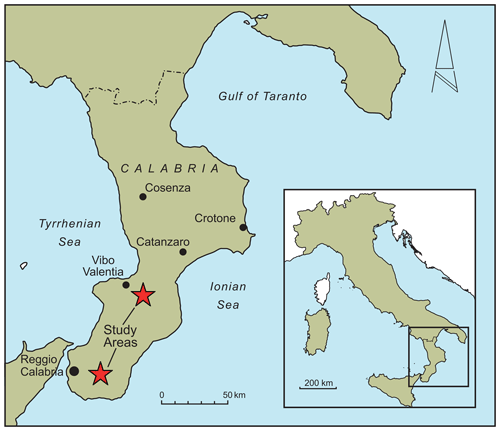
The investigation was carried out in two study areas (Mongiana and Ferraina) located across the Calabrian Apennine mountain and both covered by beech (Fagus sylvatica) and pine (Pinus nigra laricio) forests (Fig. 1). Both areas experience a temperate climate, with mild to warm summers and cool winters.
In the experimental site of Mongiana (range of elevation = 850–1050 m a.s.l.), three areas (3 ha in size) have been identified. In each area, three plots have been established to document soil erosion rates in three sub-areas in response to different silvicultural thinning practised during the last 30 years. The sub-areas consist of an undisturbed zone (control), here selected as a reference site; a zone with a traditional thinning (namely Plot 1), in which a cutting with moderate intensity was operated; and a zone with an innovative treatment (namely Plot 2), in which ca. 27 % of the total biomass was removed.
In the experimental site of Ferraina (range of elevation = 1360–1465 m a.s.l.), four plots, including two stands with Calabrian pine of different canopy covers and two stands with beech (one of which was cut in 2009), have been established. More specifically, the two pine forest stands, namely Plot 1 and Plot 2, are characterized by 50-year pine trees planted in the late 1960s during a massive re-afforestation programme (ca. 150 000 ha). The two beech forest stands, namely Plot 3 (beech forest clear-cut) and Plot 4 (beech forest undisturbed) consisted of seminatural high beech forests (ca. 140 years old). Plot 4 was not disturbed by cutting activities, except for a minimum removal of trees in the past few decades; on the contrary, Plot 3 was clear-cut in 2009 and then left to evolve naturally.
The sampling programme for 137Cs and 210Pbex measurements comprised several field campaigns aimed at collecting soil samples to characterize an undisturbed location (reference site) and the plots themselves.
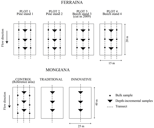
The sampling was undertaken in May 2018 in the experimental area of Mongiana and in June 2018 in Ferraina using the sampling strategy illustrated in Fig. 2.
Totally, eight final composite soil cores (six from the plots and two from the reference areas) were taken with a 10 cm diameter steel core tube driven into the soil to a depth of ca. 35 cm. Each composite core taken from the plots consisted of three single-sectioned cores combined layer by layer. Each sectioned core consisted of ca. 15–20 layers of 2 cm each. In the site of Ferraina, six additional composite bulk samples were collected for each plot to account for spatial variability. The composite core collected in the two reference areas consisted of nine single-sectioned cores combined layer by layer.
All samples provided by the sampling campaigns, namely the composite bulk cores and the sectioned cores, as well as the samples collected from the reference site were initially oven-dried at 105 °C, disaggregated, homogenized and passed through a 2 mm sieve. A representative fraction of the <2 mm fraction of each sample was then placed into a 0.5 L Marinelli beaker or, in the case of smaller samples, plastic pots (330 cm3) for determination of their 137Cs and 210Pbex activity. Before the analyses, the samples were sealed for 3 weeks based on the standard requirements for 210Pbex measurements. The samples were analysed at the Department of Agriculture of the Mediterranea University in Reggio Calabria, Italy, using high-resolution high-purity germanium (HPGe) detectors. The total inventory (Bq m−2) of each bulk core (see Table 1) was calculated as the product of the measured 137Cs activity (Bq kg−1) and the dry mass of the <2 mm fraction of the bulk core (kg), divided by the surface area associated with the core (m2).
4.1 137Cs and 210Pbex inventories at the reference sites and within the study plots
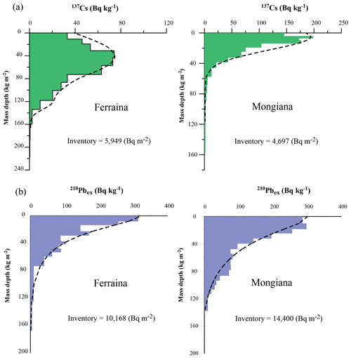
Information regarding the depth distribution of 137Cs and 210Pbex at the reference sites is reported in Fig. 3 for both study areas.
The total inventory associated with the 137Cs profiles is estimated to be 5949 Bq m−2 for Ferraina and 4697 Bq m−2 for Mongiana (see Table 1). For the 210Pbex profiles, the total inventory is estimated to be 10 168 Bq m−2 for Ferraina and 14 400 Bq m−2 for Mongiana. Table 1 provides a summary of the mean, the range and the standard deviation of the 137Cs; the 210Pbex inventories obtained within the experimental plots; and the reference sites for the two study areas.
4.2 Estimating erosion rates from the 137Cs and 210Pbex measurements obtained for the sampling points within the study plots
Estimation of erosion rates from 137Cs and 210Pbex measurements is generally based on the degree of reduction in the measured inventory relative to the local reference inventory. In this study, a diffusion and migration model has been used for the purpose of estimating the soil erosion rates indicated by the 137Cs and 210Pbex inventories measured at the sampling sites (see Porto et al., 2003, 2004, 2006, 2018). The model converts the magnitude of the reduction or increase in the radionuclide inventory relative to the reference inventory to an estimate of the rate of soil loss for uncultivated sites. Further details of this model can be found in Porto et al. (2003, 2018).
The range of the erosion rates estimated for the individual sampling points within the study plots based on the 137Cs and 210Pbex measurements are presented in Fig. 4 for each study area. The dashed lines representing the mean value of these estimates are also superimposed in the graphs for further comparison.
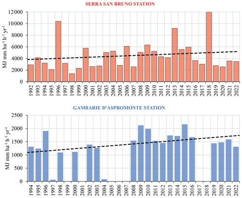
The results reported in Table 1 and Fig. 4 indicate that appreciable rates of soil erosion have occurred throughout the study plots during the time windows explored by the two radiotracers. These rates (see Fig. 4) are higher for the Mongiana site, where the values of soil loss provided by 137Cs range from 2.55 to 9.85 t ha−1 yr−1, and those obtained from 210Pbex measurements range from 6.45 to 10.75 t ha−1 yr−1. Equivalent estimates at the Ferraina site provided lower values, ranging from 0.25 to 1.33 t ha−1 yr−1 for 137Cs and from 0.77 to 3.50 t ha−1 yr−1 for 210Pbex measurements. This difference in magnitude between the two sites is related to a number of factors that include difference in rainfall erosivity, change in land use and silviculture treatments, as it was emphasized by Altieri et al. (2018) and Romeo et al. (2021). However, when the comparison is related to the two sets of estimates provided by 137Cs and 210Pbex measurements within the same study area, it can be seen that overall values of erosion rates obtained with 210Pbex are higher than those provided by 137Cs. These estimates of mean annual soil loss produced for the two study areas are also outlined in Fig. 4 (see dashed lines). The estimates of the long-term mean erosion rates derived from the 137Cs measurements relate to a period of about 65 years, extending from the commencement of fallout (1954) to the time of sampling. In contrast, because 210Pbex fallout can be considered to be essentially continuous, the equivalent estimates derived from the 210Pbex measurements will reflect a longer period of up to 110 years (ca. 5 half-lives). However, because of the relatively short half-life of 210Pbex (22.3 years), the final estimates of erosion rates obtained using this radiotracer are likely to be more sensitive to erosion occurring during the past 15–20 years. The higher soil erosion rates estimated using the 210Pbex measurements are therefore seen as a reflection of increased erosional activity in recent years in response to, for example, changes in rainfall patterns or, alternatively, changes in land use and/or silvicultural treatment (Porto and Walling, 2012; Porto et al., 2009). The increased soil loss evidenced by the experimental plots is consistent with the results of recent studies undertaken in southern Italy, where a trend of increasing rainfall erosivity during the last 15–20 years has been documented (Porto and Walling, 2012; Porto et al., 2013; Capra et al., 2017). In Fig. 5, the annual values of the rainfall erosivity factor (R factor) (Wischmeier and Smith, 1978) for the two stations of Serra San Bruno, located in the Mongiana study area, and of Gambarie d'Aspromonte, located in the vicinity of the Ferraina site, are reported. The calculations of the R factor were made using rainfall datasets related to a duration of 30 min (see Porto, 2016). The histograms presented in Fig. 5 confirm the increasing trend of the annual values of the rainfall erosivity factor during the last 30 years for both study areas.
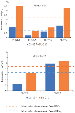
Figure 4Comparison between the ranges covered by the estimates of mean annual soil loss provided by 137Cs and 210Pbex for each study area.
A comparison between the two sets of data also reveals a higher magnitude of rainfall erosivity for the Mongiana site than for Ferraina, where the values of the R factor are ca. 1:5 of those of the former. This difference also confirms the higher absolute estimates of soil erosion rates provided by the two radiotracers for the two study areas.
The results presented above are seen as a confirmation of the potential for combining 137Cs and 210Pbex measurements to document recent changes in soil erosion in mountain areas. The results obtained from the 210Pbex measurements point to higher values of soil loss if compared to equivalent estimates provided by 137Cs. This is consistent with the trend demonstrated by independent information on changes in annual rainfall erosivity in these areas during the last 15–20 years. Further validation of this approach, particularly in different environments and in areas where soil erosion rates might be expected to be declining, could usefully be undertaken.
Data are available upon request from the author.
The author has declared that there are no competing interests.
Publisher’s note: Copernicus Publications remains neutral with regard to jurisdictional claims made in the text, published maps, institutional affiliations, or any other geographical representation in this paper. While Copernicus Publications makes every effort to include appropriate place names, the final responsibility lies with the authors.
This article is part of the special issue “Mountain Hydrology and Cryosphere”. It is a result of the International Conference on Mountain Hydrology and Cryosphere, Kathmandu and Dhulikhel, Nepal, 9–10 November 2023.
The study has been finalized in the frame of Erasmus+ KA2 – Cooperation for innovation and the exchange of good practices – Capacity building in the field of higher universities of western Balkan countries/SETOF. The author is also indebted to the Agenzia Regionale per la Protezione dell’Ambiente (ARPACAL) for providing the rainfall data used in this study.
This research has been supported by the Erasmus+CBHE project titled “Soil Erosion and Torrential Flood Prevention: Curriculum Development at the Universities of Western Balkan Countries – SETOF” (grant no. 598403-EPP-1-2018-1-RS-EPPKA2-CBHE-JP).
Altieri, V., De Franco, S., Lombardi, F., Marziliano, P. A., Menguzzato, G., and Porto, P.: The role of silvicultural systems and forest types in preventing soil erosion processes in mountain forests. A methodological approach using Caesium-137 measurements, J. Soil. Sediment., 18, 3378–3387, 2018.
Capra, A., Porto, P., and La Spada, C.: Long-term variation of rainfall erosivity in Calabria (southern Italy), Theor. Appl. Climatol., 128, 141–158, 2017.
International Atomic Energy Agency (IAEA): Guidelines for Using Fallout Radionuclides to Assess Erosion and Effectiveness of Soil Conservation Strategies, IAEA-TECDOC-1741, IAEA, Vienna, https://www-pub.iaea.org/MTCD/Publications/PDF/TE-1741_web.pdf (last access: 19 July 2024), 2014.
Porto, P.: Exploring the effect of different time resolutions to calculate the rainfall erosivity factor R in Calabria, southern Italy, Hydrol. Process., 30, 1551–1562, 2016.
Porto, P. and Walling, D. E.: Validating the use of 137Cs and 210Pbex measurements to estimate rates of soil loss from cultivated land in Southern Italy, J. Environ. Radioactiv., 106, 47–57, 2012.
Porto, P., Walling, D. E., Ferro, V., and Di Stefano, C.: Validating erosion rate estimates by caesium-137 measurements for two small forested catchments in Calabria, Southern Italy, Land Degrad. Dev., 14, 389–408, 2003.
Porto, P., Walling, D. E., and Callegari, G.: Validating the use of caesium-137 measurements to estimate erosion rates in three small catchments in Southern Italy, IAHS/AISH Publ., 288, 75–83, 2004.
Porto, P., Walling, D. E., Callegari, G., and Catona F.: Using fallout lead-210 measurements to estimate soil erosion in three small catchments in Southern Italy, Water, Air, And Soil Pollution: Focus, 6, 657–667, 2006.
Porto, P., Walling, D. E., and Callegari, G.: Investigating the effects of afforestation on soil erosion and sediment mobilisation in two small catchments in Southern Italy, Catena, 79, 181–188, 2009.
Porto, P., Walling, D. E., and Callegari, G.: Using 137Cs and 210Pbex measurements to investigate the sediment budget of a small forested catchment in southern Italy, Hydrol. Process., 27, 795–806, 2013.
Porto, P., Walling, D. E., and Callegari ,G.: Using repeated 137Cs and 210Pbex measurements to establish sediment budgets for different time windows and explore the effect of connectivity on soil erosion rates in a small experimental catchment in Southern Italy, Land Degrad. Dev., 29, 1819–1832, 2018.
Ritchie, J. C. and Ritchie, C. A.: Bibliography of publications of 137Cesium studies related to erosion and sediment deposition, USDA-ARS Hydrology and Remote Sensing Lab, Occasional Paper HRSL-2005-01, https://www.ars.usda.gov/ARSUserFiles/80420510/Cesium137/BiblioCs1372008.pdf (last access: 19 July 2024), 2005.
Romeo, F., Porto, P., Mallamaci, C., and Muscolo, A.: The relationships between selected soil properties and caesium-137 identify organic carbon, nitrogen and water soluble phenols as indicators of soil erosion processes in different forest stands, J. Forestry Res., 32, 2589–2598, 2021.
Wischmeier, W. H. and Smith, D. D.: Predicting rainfall-erosion losses. A guide to conservation farming, United States Department of Agriculture Handbook, 537, 1–151, https://books.google.it/books?id=rRAUAAAAYAAJ&printsec=frontcover#v=onepage&q&f=false (last access: 19 July 2024), 1978.


