the Creative Commons Attribution 4.0 License.
the Creative Commons Attribution 4.0 License.
 | 19 Apr 2024
Hydrodynamic Investigation of Laguna Lake, Philippines for Water Security and Flood Risk Management of Metro Manila
Eugene C. Herrera
Kensuke Naito
Laguna Lake, strategically located at the center of urban development, Metro Manila, is the focal point of national development efforts for economic activities, including flood disaster operation. It is the most stressed inland water body at the same time however, with competing and conflicting water-users, and continued environmental degradation from anthropogenic-based stressors. The use of the lake as a source of raw water for domestic supply have become more significant and critical over the past recent years with the aggravating condition of water scarcity in Metro Manila. It also serves as an important flood-detention storage for Metro Manila during the rainy season, with flow diversions from upstream Marikina river basin. This study presents a three-dimensional hydrodynamic study of Laguna Lake to understand the physical processes that govern and influence lake hydraulics for various water uses. A hydrodynamic model was set-up incorporating spatial and temporal variations in wind forcing and watershed river discharges, and dynamic sea interaction. Simulation results reveal a significant increase in lake salinity concentration for incremental increases in lake water abstraction, particularly during the dry season. A numerical experiment on bathymetric evolution also showed various Pasig River hydraulic discharge features and an increase in hydraulic residence time of the lake. Modelling analysis on the lake's flood detention function on the other hand revealed different shore-land flood inundation areas and recession durations for varying lake-flood detention levels that warrants the need for a more comprehensive and sustainable flood management operation in the metropolis. Results from this study substantiate scientific information for outlining management approaches and conservation strategies especially for fast developing environments.
- Article
(9636 KB) - Full-text XML
- BibTeX
- EndNote


Laguna Lake with substantial economic value for water resource development is the most important natural resource in the Philippines. Situated adjacent to a thriving mega city, Metro Manila, it is the focal point of national development efforts not only in the agriculture and fishery, water supply and energy sectors, but in the regional development program as well (Santos-Borja and Nepomuceno, 2003). However, it is the most stressed inland water body at the same time with competing and conflicting water-users, and continued environmental degradation from anthropogenic-based stressors. The lakes’ dynamic interaction with Manila Bay through Pasig River makes it ideal for fishery and aquaculture with the entry of salt-water, but at the same time discharges nutrient-rich polluted waters of Metro Manila and surrounding coastal provinces to the lake (Tabios III, 2020). The lake has also been traditionally utilized as a water resource for irrigation, power-plant cooling, hydropower generation, recreation, and transport route for people and products. It also serves as flood-detention storage for Metro Manila during the rainy season. More recently, it has been tapped as a source of raw water for domestic supply. Discussions on maximizing the use of the lake for this function have become more significant and critical over the past recent years with the aggravating condition of water scarcity in Metro Manila and the vicinity. With the lake's invaluable water resource, competition and conflicts among its stakeholders are common occurrences. Approximately twenty million inhabitants depend on the lake for environmental goods and services.
Flooding occurs when lakes, riverbeds, soil and vegetation cannot absorb all the water. In the case of Laguna Lake, it serves as a detention storage of floodwaters that drains the Pasig-Marikina-Laguna Lake basins during intense rainfall events. Mangahan Floodway is opened for flood diversion to Laguna Lake through the Rosario Weir when Sto. Nino (station along Marikina River) water elevation reaches 4.5 m a.s.l. (Fig. 1). By design, the Mangahan Floodway is capable of handling 2400 m3 s−1 of water flow. To complement the floodway, the Napindan Hydraulic Control Structure (NHCS) was built in 1983 at the confluence of the Marikina River and the Napindan channel of the Pasig River to regulate the storage of flood waters in the lake during extreme rainfall events, and at the same time the tidal flow of saline water from Manila Bay to prevent the intrusion of polluted water into the lake during the dry season. It has a fully gated diversion dam at its head and was designed with a width of 260 m. Over 40 000 households are situated along the floodway's banks and these shoreline slums have reduced its effective width to 220 m. The flood-control system's operational rule, that is based on flood depths and channel discharge capacities, has not been updated since its first operation in 1986. With the competing and conflicting use of the lake waters, management of this flood-detention function has not been carried-out effectively. NHCS which was to close its gates after diverting floodwaters from Marikina River (through Mangahan Floodway) to detain water temporarily in the lake as part of flood operation were almost never closed to allow saline water to enter the lake since it benefits the aquaculture industry and fisheries sector. Thus, the NHCS was practically never operated for purposes of tidal flow regulation or pollution control.
By carrying flood waters to Laguna Lake, the Mangahan Floodway lessens flood conditions in Metro Manila but contributes to flooding of the coastal areas of Taguig, Taytay, and other towns in Laguna and Rizal along the lake. Incidents of severe floods became more frequent and lasted longer in these areas since its construction. An unusual large flood occurred in October/November 1986, lasting for 2 months and resulting in high mortality and morbidity rates due to gastroenteritis and other water-borne diseases (Jorgensen and Vollenweider, 1988).
Furthermore, pollution and sediments carried by the floodway has jeopardized the existing and potential uses of the lake. The sedimentation rate of the lake is estimated at 1.5 million m3 yr−1 with the Marikina River as a major contributor of silt to the lake through the Mangahan Floodway (Santos-Borja and Nepomuceno, 2003). Additional pollution and siltation come from the shoreline settlers, living in slums up to 5 rows deep, whose waste goes directly into the floodway (JICA, 2018).
The pressures of both growing user-demand and declining water quality laid ground the value of scientific knowledge on lake environmental-functioning for the optimal and sustainable use of the lake water resources. This study investigates the hydrodynamic features of Laguna Lake with the use of high-resolution numerical modelling analyses. The study aims to clarify the circulation and transport features of the lake and provide information on the hydraulics of the lake for different lake-water use and assess critical lake ecosystem conditions.
This paper presents a three-dimensional hydrodynamic study of Laguna Lake to properly understand the physical processes that govern and influence the circulation and mass transport characteristics of the lake for various water uses. The model was set-up to take into account the physical effects of natural climatic and hydrologic factors such as discharges from rivers, direct lake rainfall and evaporation, lake groundwater interaction, wind induced circulation, and tidal fluctuation at Manila Bay. Fish pen and fish cage structures used for aquaculture, affecting lake circulation were also incorporated into the model, in addition to different lake water withdrawals. The hydrodynamic component of Delft3D, FLOW was utilized to simulate the physics of the lake. Delft3D-FLOW solves the Navier Stokes equations for an incompressible fluid, under the shallow water and the Boussinesq assumptions. In the vertical momentum equation, the vertical accelerations are neglected, which leads to the hydrostatic pressure equation. In 3D models, the vertical velocities are computed from the continuity equation. The set of partial differential equations in combination with an appropriate set of initial and boundary conditions is solved on a finite difference grid. Reference is made to the technical reference manual (Delft Hydraulics, 2007) for these formulations. The unsteady shallow-water equations were solved in 3D with a vertical sigma-coordinate system laid-out on a horizontal orthogonal curvilinear grid. Flow is forced by tide at the open boundary, wind stress at the free surface, and pressure gradients due to free surface (barotropic) and density (baroclinic) gradients. Sediment transport and morphologic changes were not included in the simulations. The hydrodynamic model was calibrated and validated using hydrographic data from field surveys and long-term monitoring information (Herrera et al., 2015; Japan International Cooperation Agency, 2018).
3.1 Flood detention operation
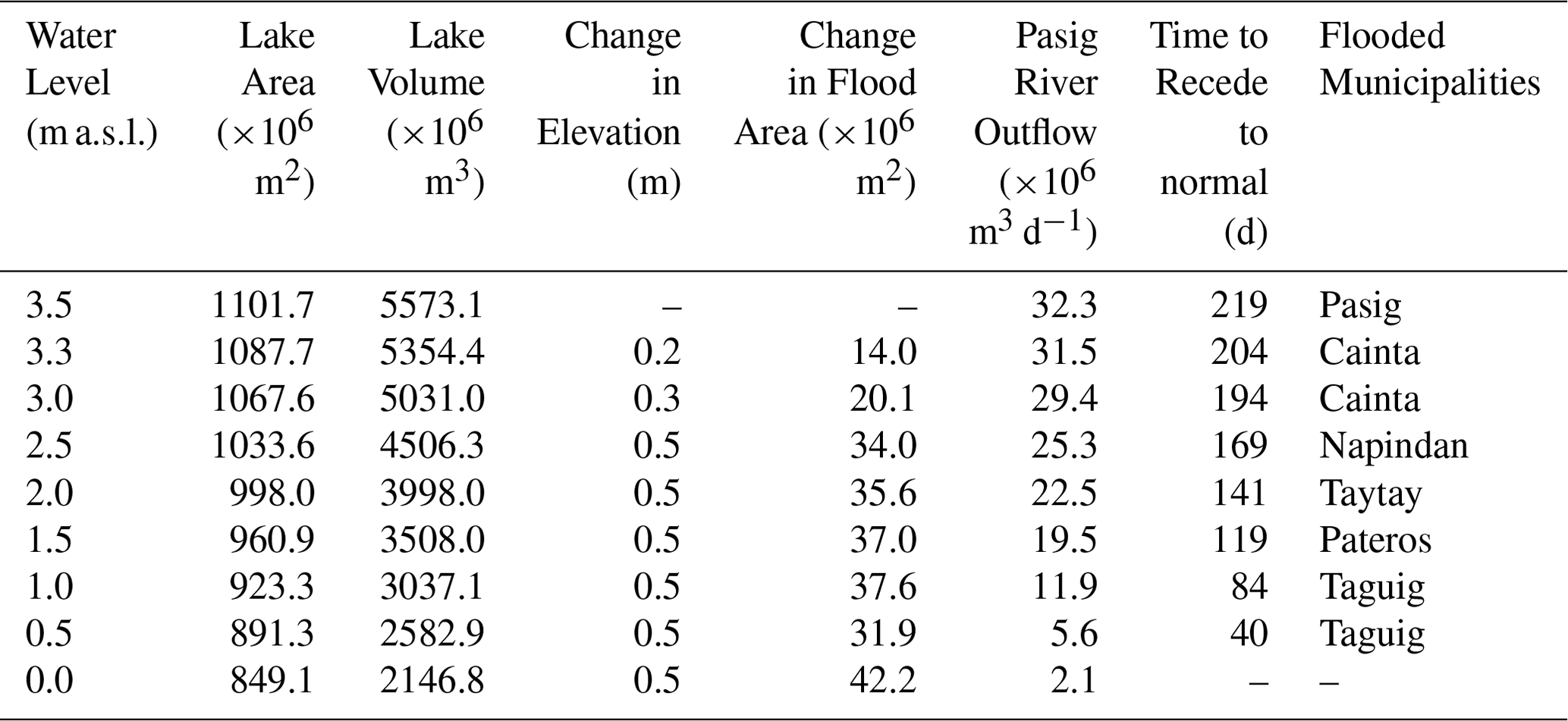
Laguna Lake serves as a flood-detention storage for Metro Manila (Fig. 1). Excess runoff discharge from Marikina Basin is diverted to the lake for temporary storage until flood waters from the watershed recedes. In 26 September 2009, typhoon Ketsana (local name Ondoy) dumped about 45 cm of rain in 12 h that resulted to widespread flooding. A 1.2 m increase in lake level that occurred due to the flood detention operation took months to recede causing flood waters in shoreland areas to last until January of the following year (Figs. 2 and 3). Although, the volume of water generated by Ketsana would have resulted to flooding nonetheless even with a fully operational flood management and control system, there are measures that can be taken to reduce the impact of such extreme event to a predetermined safety level. Among these include effective regulation of both Mangahan Floodway and NHCS operation using updated hydraulic information, enhancement of the monitoring and early warning system within the Pasig-Marikina-Laguna Lake basin, increasing the flow capacity of Napindan channel, and others. Scenario simulations revealed different shore-land flood inundation areas and recession durations for varying lake flood detention levels (Fig. 3 and Table 1). Pasig takes the longest time to recede back to normal water levels (10.5 m based on Laguna Lake Development Authority datum) at roughly 219 d. It is followed by Cainta at 194–204 d, then Napindan at 169 d, Taytay at 141 d, Pateros at 119 d and Taguig at 40–84 d. Other flooding hydraulic details from the hydrodynamic modelling conducted are presented in Table 1.

Figure 1Metro Manila flood mitigation infrastructures and surrounding watersheds and water bodies.
Although the operation of these existing flood control infrastructure (Rosario Weir, Mangahan Floodway, and NHCS) during typhoon Ketsana lessened the flood conditions in Metro Manila, it significantly contributed to flooding of the coastal areas around Laguna Lake. Based on the results of the numerical simulation (Fig. 3 and Table 1), there is an apparent need to effectively manage the operation of the lake for flood detention so as not to cause flooding to shoreland communities. The results also call for immediate action on updating the operational rule of the flood control system and improving the discharge capacities of the critical channels in the system, particularly the Mangahan Floodway, Napindan channel, Pasig River and lower Marikina River.
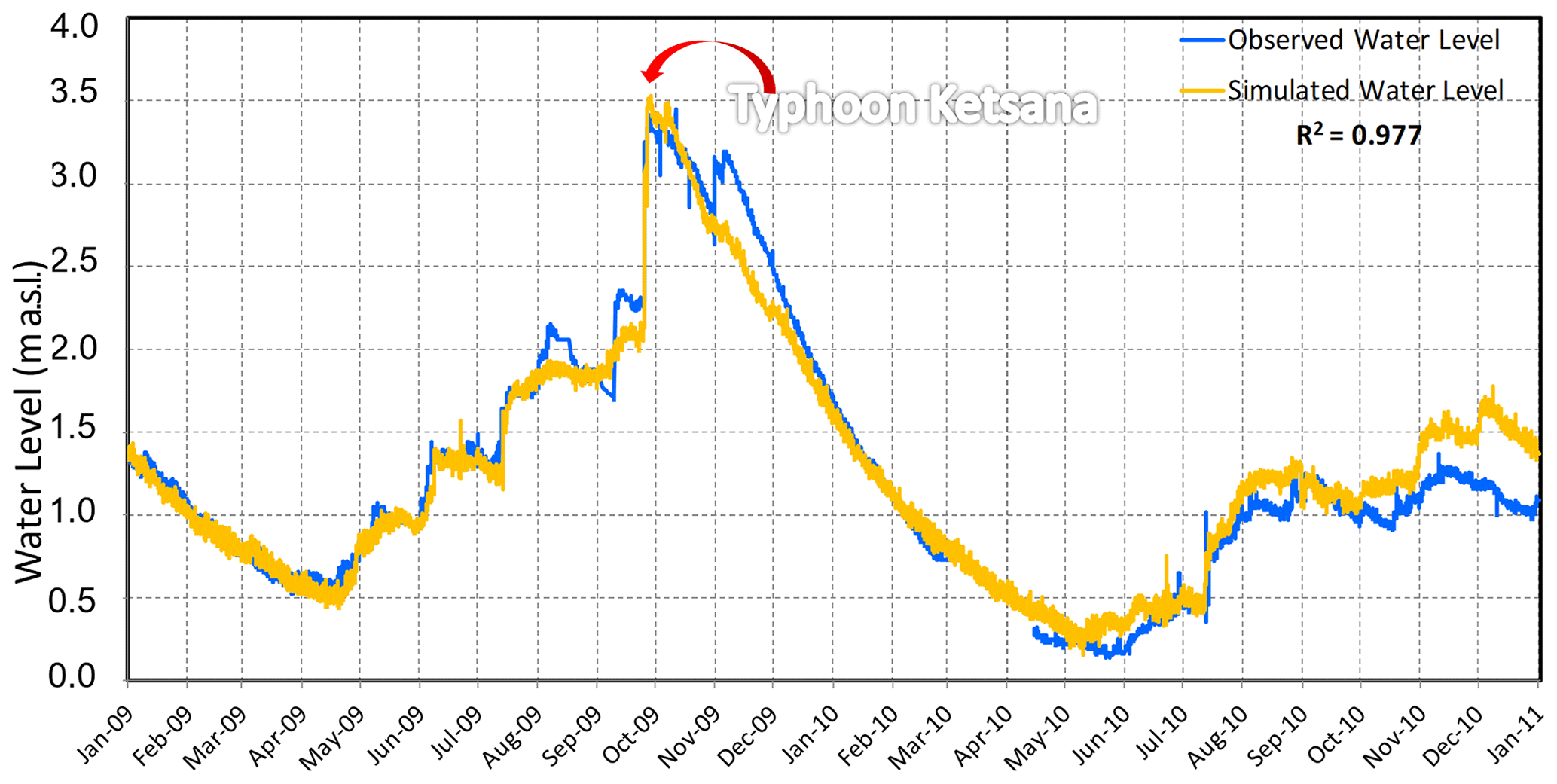
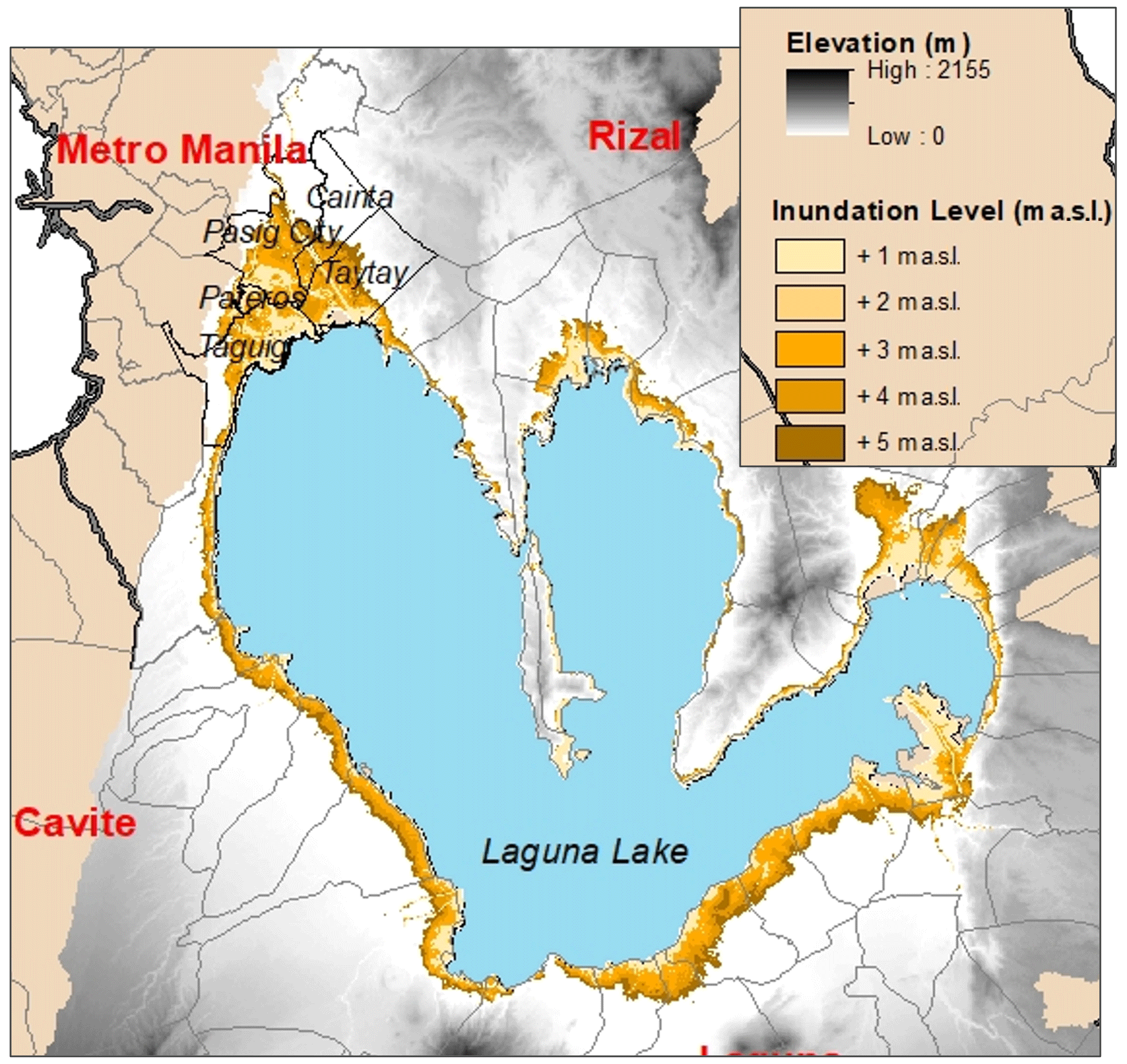
Figure 3Laguna Lake shoreland flooding at different inundation levels.
Table 1Hydrodynamic matrix of Laguna Lake during flood detention operation.
3.2 Bathymetric change and eutrophic vulnerability
The watershed of the lake has undergone significant changes from population growth, urbanization, industrialization, and land use conversion, resulting to increased siltation, eutrophication and pollution (Nauta et al., 2003). Rivers emptying to the lake unload wastes, organic matter, and sediments that settle and accumulate on the lakebed. A hydrodynamic model experiment for different lake bathymetric configuration (1963, 1983 and 2008) showed various Pasig River hydraulic discharge features and an increase in hydraulic residence time of the lake in terms of salinity distribution (Fig. 4). The historical change in lake bathymetry from years of deposition, erosion and reworking of sediments brought forth the changes in circulation pattern that led to the longer residence time of the lake. Erosion and deepening in the northern west and east lobes of the lake in particular could have retarded lake outflow-directed circulation. More polluted seawater was also observed to be intruded during the dry season due to the longer lake residence time. Seawater entry demonstrated larger extent in intrusion plume as a result which further established the increase in eutrophic vulnerability and higher potential for adverse response to eutrophication of Laguna Lake in recent years. Thus, it is revealed from the numerical experiment that eutrophic vulnerability in Laguna de Bay is not a simple function of anthropogenic waste loading but watershed sediment input as well with the accompanying changes in circulation patterns. Results from this numerical scenario analysis warrants the need for a better management of the sediment and pollution loading of rivers to the lake.

Figure 4Hydrodynamic simulation for seawater intrusion plume of the 2008, 1983 and 1963 lake bathymetric scenarios.
3.3 Increasing lake abstractions and lake hydrodynamics
Scenario simulations were also conducted to study the impact of increased lake water abstractions on the lake hydrodynamics, particularly the entry of polluted salt water from Manila Bay through the Pasig River. Simulation results reveal a significant increase in lake salinity concentration for incremental increases in lake water abstraction, particularly during the dry season. Different abstraction scenarios corresponded to different current movement patterns and concentration distributions of the lake saltwater plume (Figs. 5 and 6). With the drop in lake water level by about 1.5–2.0 cm for every 400 million L d−1 lake water abstraction during the dry season, Pasig River backflow (Manila Bay to Laguna Lake) is induced by the intensified hydrodynamic imbalance between the lake and the bay resulting to higher incidence of lake salinity intrusion. With the drop in annual average Pasig River outflow (Laguna Lake to Manila Bay), the eventual exit of saline water from the lake (the lake hydraulic residence time), will take a longer period compared to the hydrodynamic condition without abstraction, increasing Laguna Lake's eutrophic vulnerability. In spite of the sheer volume of the lake waters, and its high potential for raw water abstraction and use, a scientific-based permitting guideline needs to be in place to sustainably manage requests for water abstraction and prevent any deleterious effects on the lake's environmental functioning.
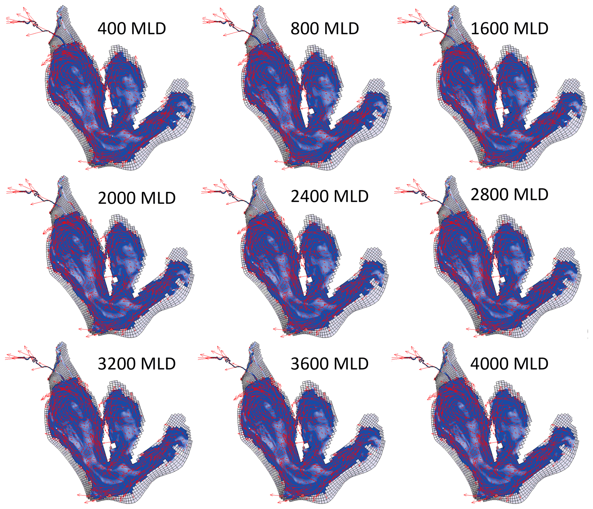
Figure 5Laguna Lake circulation patterns for various abstraction rates.

Figure 6Laguna Lake dry season salinity plume in parts salinity units for various abstraction rates.
A 3-dimensional hydrodynamic model was set-up for Laguna Lake, Philippines using Delft-3D to properly understand the physical and environmental processes that govern and influence the lake dynamics. The water balance of the lake was analyzed by taking into account the physical effects of all natural climatic and hydrologic factors, as well as man-made interventions. Field measurement data on various water quality and hydrodynamic parameters were used for the calibration and validation of the model. Observed lake parameters were reproduced by the model within acceptable limits of accuracy.
In general, in spite of the data limitations, the hydrodynamic set-up and simulation results showed that the hydrodynamic model can describe the water balance and transport processes in Laguna Lake within sound degree of accuracy. The validated model was able to provide useful information for understanding the dynamic condition of the lake and for predicting the impacts of future man-made interventions, such as temporary flood detention and water abstraction for domestic use. Baseline information has been generated to form the scientific foundation of probable protective regulations and policies for Laguna Lake. Considering Laguna Lake is a multi-purpose reservoir, water allocation and flood-detention function require greater analysis and understanding of the dynamics of its environment for it to be managed sustainably. Thus, deeper and better understanding of the lake dynamics generated can serve as a sound basis for lake management options and for further research undertakings, essential for the lake's optimal and sustainable use as a multi-purpose resource, while preserving its environmental integrity at the same time.
Only processed data directly used for the final version of the model are available upon request. Raw data are to be gathered from the agencies from which the authors collected such datasets.
ECH conceptualized, set up and simulated the models, conducted the extraction, analysis, and documentation of model results. KN reviewed the abstract and supported the overall study for its submission to the ICFM9 conference.
At least one of the (co-)authors is a guest member of the editorial board of Proceedings of IAHS for the special issue ”ICFM9 – River Basin Disaster Resilience and Sustainability by All”. The peer-review process was guided by an independent editor, and the authors also have no other competing interests to declare.
Publisher’s note: Copernicus Publications remains neutral with regard to jurisdictional claims made in the text, published maps, institutional affiliations, or any other geographical representation in this paper. While Copernicus Publications makes every effort to include appropriate place names, the final responsibility lies with the authors.
This article is part of the special issue ”ICFM9 – River Basin Disaster Resilience and Sustainability by All”. It is a result of The 9th International Conference on Flood Management, Tsukuba, Japan, 18–22 February 2023.
The authors would like to express gratitude to Laguna Lake Development Authority, to their former Integrated Water Resources Management Division for all the assistance and logistical support during the field surveys, as well as the maintenance of the IMSWES monitoring platform. Appreciation is also given to the Department of Science and Technology (DOST) for facilitating the entry of instruments. This research was supported by The Japan Society for the Promotion of Science (JSPS) Grant-in-Aid for Scientific Research [No. 18254003, No. 20121007 and No. 21254002]; JSPS Core University Exchange Program; Asia-Pacific Network (APN) Grant [ARCP2006-08NMYNadaoka]; Science and Technology Research Partnership for Sustainable Development (SATREPS) in collaboration between Japan Science and Technology Agency (JST, JPMJSA1909) and Japan International Cooperation Agency (JICA); and the Department of Science and Technology (DOST) and DOST Philippine Council for Industry, Energy and Emerging Technology Research and Development (DOST-PCIEERD) through the project Eco-System Modelling and Material Transport Analysis for the Rehabilitation of Manila Bay (e-SMART) under the IM4ManilaBay Program.
This research has been supported by the Science and Technology Research Partnership for Sustainable Development (grant no. JPMJSA1909) and the Department of Science and Technology, Philippines (grant no. Eco-System Modelling and Material Transport Analysis for the Rehabilitation of Manila Bay (e-SMART) Project).
This paper was edited by Shinji Egashira and reviewed by two anonymous referees.
Delft Hydraulics: Simulation of multi-dimensional hydrodynamic flows and transport phenomena, Delft3D-FLOW User Manual Version 3.14, WL/ Delft Hydraulics, the Netherlands, 642 pp., https://content.oss.deltares.nl/delft3d4/Delft3D-FLOW_User_Manual.pdf (last access: 4 March 2024), 2007.
Herrera, E. C., Nadaoka, K., Blanco, A. C., and Hernandez, E. C.: Hydrodynamic Investigation of a Shallow Tropical Lake Environment (Laguna Lake, Philippines) and Associated Implications for Eutrophic Vulnerability, ASEAN Engineering Journal, 4-1, 48–62, https://doi.org/10.11113/aej.v4.15432, 2015.
Japan International Cooperation Agency: Resettlement Action Plan for Mangahan Floodway, Pasig-Marikina River Channel Improvement Project Phase IV Report, 1-1–1-3, September 2018.
Jorgensen, S. E. and Vollenweider, R. A. (Eds.): Principles of Lake Management, in: Guidelines of Lake Management, International Lake Environment Committee Foundation, United Nations Environment Programme, 191 pp., ISBN: 4-906356-27-3, 1988.
Nauta T. A., Bongco, A. E., and Santos-Borja, A. C.: Set-up of a decision support system to support sustainable development of the Laguna de Bay, Philippines, Mar. Pollut. Bull., 47, 211–218, https://doi.org/10.1016/S0025-326X(02)00407-1, 2003.
Santos-Borja, A. and Nepomuceno, D.: Experience and Lessons Learned Brief for Laguna de Bay, Philippines, Presented in the Lake Basin Management Initiative ILEC/LakeNet Regional Workshop for Asia: Sharing Experience and Lessons Learned in Lake Basin Management, Manila, Philippines, 1–4 September 2003, 225–258, https://iwlearn.net/documents/6001 (last access: 4 March 2024), 2003.
Tabios III, G. Q.: Water Resources Systems of the Philippines: Modeling Studies, 4, 403 pp., ISBN 978-3-030-25400-1, Springer Nature, Switzerland, https://doi.org/10.1007/978-3-030-25401-8, 2020.