the Creative Commons Attribution 4.0 License.
the Creative Commons Attribution 4.0 License.
 | 19 Apr 2024
Designing and Developing Dynamic Decision Support Information for Disaster Response
Hiroaki Sano
Yuichiro Usuda
Recently, Japan has been struck by extremely heavy rains and serious floods. To plan for disaster response, it is needed to consider various information such as precipitation, water level of rivers, weather forecasts, and so on. However, it requires high skill to integrate this information to utilize. Our study aims to provide the decision support information for both the national and the local governments by dynamic risk analysis to enforce disaster resilience. To demonstrate the effectiveness of disaster dynamics analysis, we have developed the “Dynamic Decision Support System for Disaster Response (DDS4D)”. DDS4D synthesizes natural observation data, social observation data, and geospatial data to provide decision support information that fits decision maker's the situational awareness in real time. Verifying several information products generated by DDS4D in the actual flood in Japan, we confirmed that they could support decision making of government.
- Article
(6408 KB) - Full-text XML
- BibTeX
- EndNote


The information sharing capability is the highest priority feature for the disaster information system. Even if the system has excellent functions, without information sharing capability, it may not perform properly in a serious disaster situation (UN-GGIM, 2017). To address this issue, we, National Research Institute for Earth Science and Disaster Resilience (NIED), have developed the “Shared Information Platform for Disaster Management (SIP4D)” to establish the inter-organizational common situational awareness under disaster situations (Hanashima et al., 2017). Previous studies have pointed out the importance of shared situational awareness in the coordination of the disaster response agencies (Bando and Machida, 2015; Kondo et al., 2019). Based on an extensive review of previous research, Sophronides et al. (2017) noted that shared situational awareness (SSA) is essential to prevent potential adverse effects and implement emergency response without delay in emergencies in which various organizations operate toward different goals. They also note that data acquisition from multiple sources and sharing information through network-centric systems contributes to the creation of a common operational picture which can support all the responding units to have the same understanding and awareness (shared situational awareness) of information and emergency status when conducting operations. The design concept of SP4D (Usuda et al., 2019) is to realize the above points made by Sophronides et al. as an actual system. The effectiveness of information sharing through SIP4D in establishing shared situational awareness in disaster response has been demonstrated in the actual disaster response (Ise et al., 2017).
Through our experience with SIP4D in several major disasters, we have found that shared situational awareness does not always activate to effective disaster response. In emergency situations, it is often difficult for the decision maker to process shared information, resulting in situations where information is shared but not fully utilized (Ise et al., 2022). This issue implies the need for a mechanism to assist decision makers, i.e., a decision support system, as well as shared situational awareness (Valachamy et al., 2022).
In a comprehensive review of decision support systems, Akter and Wamba (2019) state that in disaster response, a real-time data-driven analytics platform needs to be developed to prioritize urgent issues, prevent subsequent disasters, coordinate support organizations, and dispatch first responders. They also state that the major challenge is to develop a data integration protocol that ensures proper data collection, modelling, and notification systems.
Ka Hong et al. (2020) point out in their review that most current Disaster Management Decision Support Systems (DMDSS) focus on resource management as a method of managing tasks. They also state that, therefore, future DMDSS must include the study of task complexity to increase its reliability and accuracy in advising the task performer which task should be completed first. To address these issues, Zhang et al. (2019) have developed a system that automates decision support by weighting tasks using multi-criteria decision analysis models and GIS. This research is innovative in that it focuses on supporting group decision making and collaborative problem solving by combining various social vulnerability indices and social media data, rather than technical improvements in task management.
However, it is expected that even sophisticated decision support methods will not be fully effective during the imminent and initial phases of a disaster, because it is difficult to obtain sufficient information about the disaster situation. In addition, users often lack the skills to interpret the decision support information provided by the system and reflect it in their actions. This is not a problem of system functionality, but it is an issue that must be considered in the concept of decision support.
To address these issues, a technology-driven approach alone is not sufficient. This is because a technology-driven approach tends to focus on specific technologies and tools for handling information and may neglect to consider what is critical to information for decision-making (Neuvel et al., 2012; Usuda, 2021).
Through discussions with practitioners in charge of disaster management at the Cabinet Office (CAO), we have identified the following three simple requirements for information content for decision support.
- a.
Bringing information closer to the interests of decision makers.
- b.
Match the granularity of information to the decision maker's point of view.
- c.
Responding immediately to issues that arise in the field of disaster response.
We believed that by implementing a function in SIP4D to generate information that meets these requirements, the shared information should truly be useful for decision making in disaster response. To demonstrate this concept, we developed DDS4D as a proof-of-concept model and conducted a demonstration experiment using actual disaster data.
Currently, information content that meets the previously mentioned requirements must be created manually. In the event of a catastrophe such as the Nankai Trough Earthquake, such a response will be impossible. Therefore, DDS4D must be able to generate the required information content without human intervention and on a regular basis.
DDS4D was designed by mapping the above three requirements to the following practical use cases.
To satisfy requirement “a”, it is necessary to generate information that integrates disaster hazard data and the extent of expected damage.
For example, heavy rainfall as a hazard is provided by SIP4D in the form of grid data, but it is difficult to determine where and how much damage will occur from this data alone. In this case, the population of residents and number of buildings in the grid where heavy rainfall is occurring should be analysed together with rainfall data to provide information on estimated inundation damage.
Furthermore, if the estimated information is provided as grid data, The decision makers would have to replace it with the administrative areas. In this case, the grid data should be aggregated and provided by the administrative districts. This is the optimization of information granularity to satisfy requirement “b”.
Finally, disaster response may require information that cannot be anticipated in advance. The 2019 Boso Peninsula typhoon caused massive power outages throughout Chiba Prefecture, requiring the identification and mapping of elderly welfare facilities that did not have their own power generation systems, but this type of information is not typically used in disaster response. To support decision making, such ad hoc information needs to be provided in a timely manner. This corresponds to requirement “c”.
3.1 Functional requirements for decision making
In designing the DDS4D proof-of-concept model, we implemented the following three features to be able to demonstrate the previously mentioned requirements.
The first is “Foresight on potential municipalities to support”. For the demonstration, DDS4D estimates damage using forecast data and estimate municipalities that should be supported. This analysis will be useful for quantitative decisions such as the number of dispatching supports. We show the example of this demonstration, supporting decisions based on Disaster Relief Act application predictions.
The second is “Nationwide, uniform, comprehensive and quantitative monitoring of abnormalities”. For the demonstration, DDS4D continuously and automatically detects municipalities where evacuation instructions have not been issued even though there is a high risk of disaster. It will prevent omissions of evacuation instructions. We show the example of this demonstration, preventing delay of issuing the evacuation instructions.
The third is “Automatic detection of municipalities that will require support changes”. For the demonstration, DDS4D detects that even if the estimated scale of damage is the same, there is a large difference in the response of basic local governments, such as the investigation of damage certification. This analysis will be utilized to detect the need to dispatch specialist staff, etc.
3.2 Architecture and functions of DDS4D
DDS4D is constructed from three sub systems, “DDS-DB”, “DDS-SY” and “DDS-VI”. The three subsystems operate autonomously and mutually collaborate with each other, triggered by data updates and user demand (see Fig. 1).
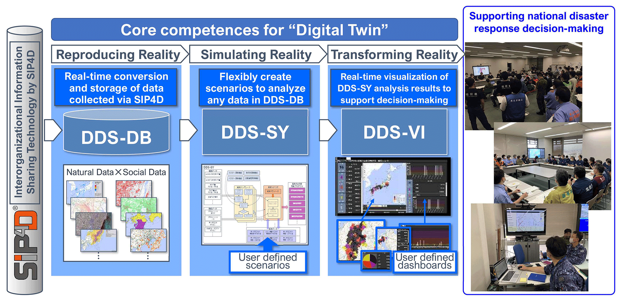
Figure 1System design concept of “DDS4D”. (All base maps are based on the GSI Maps published by Geospatial Information Authority of Japan).
Disaster Dynamics Spatiotemporal Database, DDS-DB, is a large-size spatiotemporal database which records dynamic disaster data as time series geospatial data.
To be able to store all kinds of disaster dynamic data aggregated by SIP4D as spatiotemporal data with low latency at each update timing, DDS-DB has high-speed conversion capability for vector-type geospatial data between raster data. DDS-DB automates spatial processing between regular geospatial data and store the processing results in time series. It also has the ability to automatically generate the Representational State Transfer Application Programming Interface (REST API) for external systems to retrieve data from DDS-DB. Moreover, DDS-DB archives automatically the original data files over the medium to long term and easily restores the original data.
Disaster Dynamics Synthesizer, DDS-SY, is the agile data analysis infrastructure which operates the dynamic analysis based on the user-definable analysis scenario.
User can create and modify the scenarios according to the data processing flow. Once defined, the scenarios are automatically executed when the data are updated. The multiple spatial operations, the time-series operations, and the conditional judgments can be executed in parallel using the dynamic disaster data stored in DDS-DB as input. The processing results can be stored in DDS-DB as spatiotemporal datasets.
To provide an agile way to define a series of processes (analysis scenarios) arbitrarily by the user and automatically executed, it has simple Graphical User Interface (GUI) for creating, executing, and controlling analysis scenarios.
Disaster Dynamics Visualizer, DDS-VI, is the visualization sub-system for decision support that can draw maps and graphs in real time based on the information products created by DDS-SY. User can define the screen layout and presentation of information using GUI on their purpose.
To be able to display the DDS-VI, a web-based dashboard that lists dynamic disaster information for use by disaster response agencies, using dynamic disaster data according to an arbitrarily defined layout. To monitor updates to the data displayed in the DDS-VI and automatically update the contents of the display.
DDS-VI's GUI should be able to seamlessly display time-series data, and link lists, maps, and graphs to time-axis operations.
4.1 Rapid Evaluation of the Disaster Relief Act
Figure 2 shows the analytic framework for demonstration of the “Rapid evaluation of the Disaster Relief Act”. This law is constituted to provide financial supports for affected municipalities and its support levels are defined based on the number of damaged households. DDS4D estimates the number of households that affected by flood and evaluates which municipalities are eligible to apply for the Disaster Relief Act. We defined the following process as the analysis scenario on DDS4D.
-
Step 1: Analyze the number of buildings will be exposed heavy rainfall within the inundation hazardous areas.
-
Step 2: Aggregate the number of buildings analyzed in “Step1” by municipalities.
-
Step 3: Estimate the number of households will lose housings based on the result of “Step2” by applying the evaluation model.
-
Step 4: Based on the result of “Step3”, evaluate which clause of the Disaster Relief Act will be applied.
If the rain fall forecast is used instead of the effective rainfall, these analytics could predict the status hours later.
DDS4D performs this scenario every 30 min.
These information products can contribute to decision making at the national level, i.e., to make a nationwide estimate of the possible damage caused by the disaster and to support local governments; at the prefectural level, to support municipalities by making a quantitative estimate of the damage at an early stage of disaster response; and at the municipal level, to decide whether to apply for the Disaster Relief Act at an appropriate time.
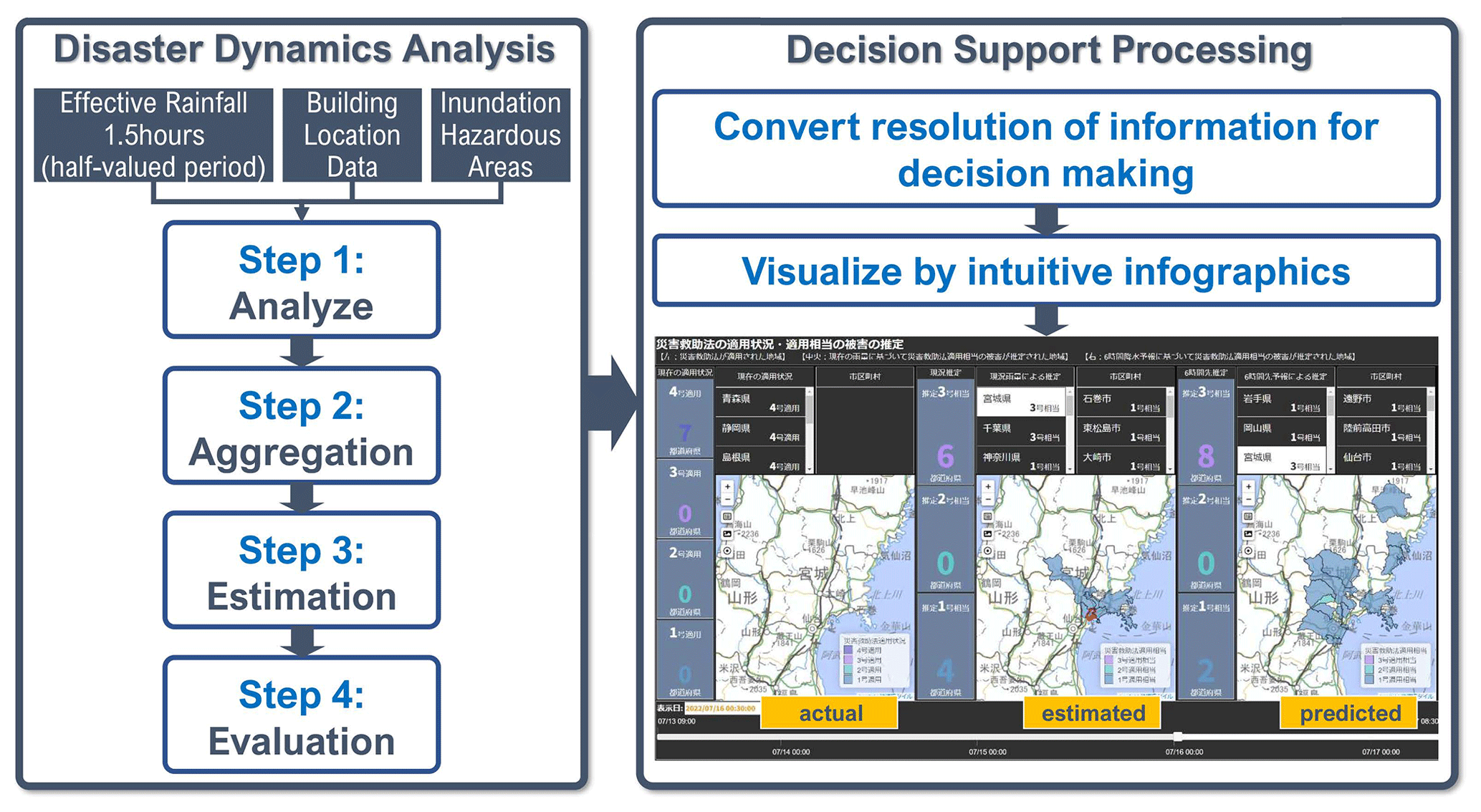
Figure 2Analytic framework for “Rapid evaluation of the Disaster Relief Act”. (All base maps are based on the GSI Maps published by Geospatial Information Authority of Japan).
Figure 3 shows actual screen images of DDS-View at the heavy rain in Miyagi prefecture, 16 July 2022.
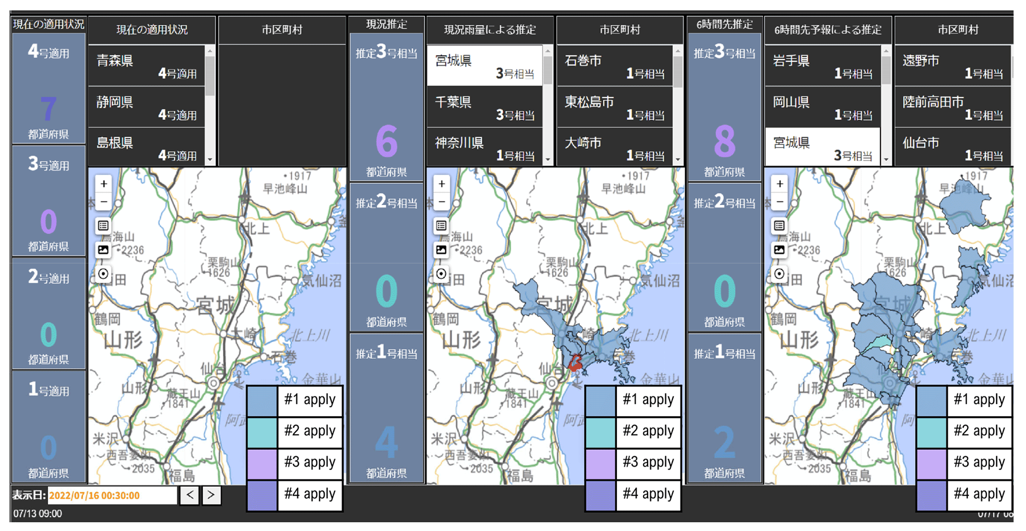
Figure 3DDS4D shows the estimated results at 00:30 JST (Japan standard time), 16 July 2022. (The map shown on the centre) (All base maps are based on the GSI Maps published by Geospatial Information Authority of Japan).
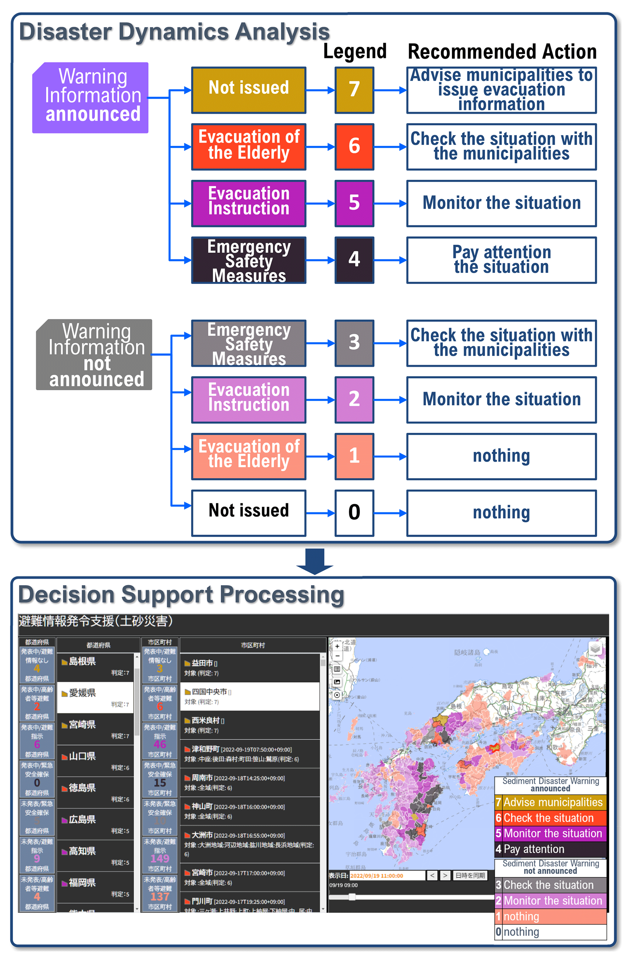
Figure 4Analytic framework for demonstration of “Decision support for evacuation instruction”. (The base map is based on the GSI Maps published by Geospatial Information Authority of Japan).
Each three map shows actual, estimated, and predicted data for local governments which are applied the Disaster Relief Act, generated by the scenario shown in Fig. 2.
At 00:30 JST (Japan standard time) on 16 July, DDS4D evaluated that Osaki City might be suffered enough damage to be covered by the Disaster Relief Act and other municipalities will be suffered in next 6 h.
At 15:00 JST on 16 July, Miyagi prefecture applied the Disaster Relief Act to Osaki city and Matsushima town. The estimation time was 14.5 h earlier than the published time the act applied. It means that the municipalities could have more time for preparation of disaster relief action when they refer the information products provided by DDS4D.
4.2 Demonstration of decision supporting functions
Figure 4 shows the analytic framework for demonstration of “Decision support for evacuation instruction”.
According to CAO's evacuation information guidelines, it is recommended that municipalities issue the evacuation instruction when the sediment disaster warning information is announced. The government officers are supposed to keep track of municipalities that have been announced the sediment disaster warning information and have not yet issued the evacuation instruction and provide technical assistance as needed. However, it requires a great deal of effort to constantly check both the status of evacuation information issued by the more than 1700 municipalities nationwide and the status of sediment disaster warning information. Therefore, we have defined an analysis scenario that automatically performs this cross judgment and have DDS4D perform it every 10 min.
The decision to issue evacuation information is made by the mayor of the municipality and is not enforced by the government but detecting municipalities that are unable to decide due to a lack of information and confirming in advance whether assistance is required would be effective in preventing delays in issuing evacuation information.
The decision to issue evacuation information is made by the mayor of the municipality and is not enforced by the government, but detecting municipalities that are unable to decide due to a lack of information and confirming in advance whether assistance is needed would be effective in preventing delays in issuing evacuation information.
When Typhoon No. 14 approached Japan in 2022, DDS4D detected delays in issuing evacuation notices in 41 municipalities. It can be inferred that some decision-making problems occurred in municipalities that remained unannounced for several hours.
By using DDS4D, government emergency management personnel can be relieved of the complicated task of comparing multiple sources of information to monitor delays in issuing evacuation orders. They can then focus on assisting communities that are hesitant to issue evacuation orders.
In this paper, we described the design concept and a practical demonstration case of DDS4D, a decision support system for decision makers in administrative disaster response. In the DDS4D decision support demonstration during the 2022 flood season, we developed about 20 kinds of dynamic analysis scenarios and verified their effectiveness by generating information content using actual disaster data. Although the cross-judgement to support the issuance of evacuation information is still being tested by government disaster management officials and specific examples are still being collected, this decision support information was developed through collaboration between the research team and government staff, an achievement that would not have been possible without the agile analysis scenario development capabilities of DDS4D.
The results of the DDS4D demonstration were presented to disaster management personnel in the three prefectures, and interviews were conducted. As a result, the three requirements established in the DDS4D design were evaluated as appropriate to support disaster response decision making. In addition, the information products generated by DDS4D were evaluated as unique and useful as decision support information. We believe that this fact demonstrates the effectiveness of the DDS4D design philosophy, i.e., the back-casting approach of defining the requirements of the information to be generated from the decision maker's point of view and reflecting them in the system architecture and demonstrates the originality of DDS4D. On the other hand, the development of DDS4D so far has focused on building an agile development platform for decision support and has not pursued the accuracy and validity of the analysis methods. Some disaster management personnel requested that the information be more persuasive and simpler to present to higher-level decision makers (e.g., prefectural governors). The future challenge is to improve the quality of analysis scenarios by introducing more accurate analysis methods and models with better explanatory power.
Since the programs mentioned in this paper are under continuous development, there are no plans to release the source code at this time. The copyright of the program belongs to NIED.
Because the data used in this paper include paid data, they cannot be made public due to data terms of use. For further information, please contact to the corresponding author.
MH was responsible for the conceptual design of DDS4D, directed the system development, and wrote the manuscript for this paper. HS was responsible for the development and demonstration of the disaster dynamics analysis methodology and contributed to the implementation of the analysis scenario presented in this paper. YU supervised the overall research and the conceptual framework of this paper.
The contact author has declared that none of the authors has any competing interests.
Publisher’s note: Copernicus Publications remains neutral with regard to jurisdictional claims made in the text, published maps, institutional affiliations, or any other geographical representation in this paper. While Copernicus Publications makes every effort to include appropriate place names, the final responsibility lies with the authors.
This article is part of the special issue “ICFM9 – River Basin Disaster Resilience and Sustainability by All”. It is a result of The 9th International Conference on Flood Management, Tsukuba, Japan, 18–22 February 2023.
The content of this paper was conducted as a part of “Enhancement of National Resilience against Natural Disasters” of the Cross-ministerial Strategic Innovation promotion Program (SIP) by the Council for Science, Technology, and Innovation.
This research has been supported by the Council for Science, Technology and Innovation.
This paper was edited by Mohamed Rasmy and reviewed by two anonymous referees.
Akter, S. and Wamba, S. F.: Big data and disaster management: a systematic review and agenda for future research, Ann. Oper. Res., 283, 939–959, https://doi.org/10.1007/s10479-017-2584-2, 2019.
Bando, M. and Machida, C.: For sharing disaster information in local government: Through inter-departmental cooperation of disaster prevention and medical affairs, J. Jpn. Soc. Civ. Eng. Ser F6 (Saf. Probl.), 71, I_205–I_212, https://doi.org/10.2208/jscejsp.71.i_205, 2015.
Hanashima, M., Sato, R., and Usuda, Y.: The Standardized Disaster-Information Products for Disaster Management: Concept and Formulation, J. Disaster Res., 12, 1015–1027, https://doi.org/10.20965/jdr.2017.p1015, 2017.
Ise, T., Takahashi, T., Sato, R., Sano, H., Isono, T., Hanashima, M., and Usuda, Y.: Consideration on Utilization of Information in Disaster Response Site – Based on Information Support for 2016 Kumamoto Earthquakes, J. Disaster Res., 12, 1028–1038, https://doi.org/10.20965/jdr.2017.p1028, 2017.
Ise, T., Hanashima, M., and Usuda, Y.: Current status and issues of information sharing in disaster response in Japan: Information linkage by “SIP4D,” J. Disaster Res., 17, 976–984, https://doi.org/10.20965/jdr.2022.p0976, 2022.
Ka Hong, S. G., Ahmad, A., Raja Azman, R. F., and Faudzi, M. A.: Exploratory Review on Decision Support System for Disaster Management, in: 2020 8th International Conference on Information Technology and Multimedia (ICIMU), Selangor, Malaysia, 24–26 August 2020, 390–394, https://doi.org/10.1109/ICIMU49871.2020.9243314, 2020.
Kondo, Y., Ichikawa, M., Kondo, H., Koido, Y., and Otomo, Y.: Current disaster medicine in Japan and the change brought by information sharing, J. Disaster Res., 14, 292–302, https://doi.org/10.20965/jdr.2019.p0292, 2019.
Neuvel, J. M. M., Scholten, H. J., and van den Brink, A.: From spatial data to synchronised actions: The network-centric organisation of spatial decision support for risk and emergency management, Appl. Spat. Anal. Polic., 5, 51–72, 2012.
Sophronides, P., Papadopoulou, C.-A., Giaoutzi, M., and Scholten, H. J.: A Common Operational Picture in Support of Situational Awareness for Efficient Emergency Response Operations, Journal of Future Internet, 102, 10–35, https://doi.org/10.18488/journal.102.2017.21.10.35, 2017.
UN-GGIM: UN Strategic Framework on Geospatial Information and Services for Disasters, https://ggim.un.org/documents/UN-GGIM_Strategic_Framework_Disasters_final.pdf (last access: 14 November 2022), 2017.
Usuda, Y.: Forefront of disaster information sharing systems: Supporting disaster responses using SIP4D, IEICE Commun. Soc. Mag., 15, 192–199, https://doi.org/10.1587/bplus.15.192, 2021.
Usuda, Y., Matsui, T., Deguchi, H., Hori, T., and Suzuki, S.: The Shared Information Platform for Disaster Management – The Research and Development Regarding Technologies for Utilization of Disaster Information, J. Disaster Res., 14, 279–291, 2019.
Valachamy, M., Sahibuddin, S., Ahmad, N. A., and Bakar, N. A. A.: Critical success factors for geospatial data sharing in disaster management, IOP Conference Series: Earth and Environmental Science, 1064, 012038, https://doi.org/10.1088/1755-1315/1064/1/012038, 2022.
Zhang, Z., Hu, H., Yin, D., Kashem, S., Li, R., Cai, H., Perkins, D., and Wang, S.: A cyberGIS-enabled multi-criteria spatial decision support system: A case study on flood emergency management, Int. J. Digit. Earth, 12, 1364–1381, https://doi.org/10.1080/17538947.2018.1543363, 2019.
- Abstract
- Introduction
- Fundamental design of DDS4D
- System overview of DDS4D
- Demonstration of decision supporting functions
- Conclusion
- Code availability
- Data availability
- Author contributions
- Competing interests
- Disclaimer
- Special issue statement
- Acknowledgements
- Financial support
- Review statement
- References