the Creative Commons Attribution 4.0 License.
the Creative Commons Attribution 4.0 License.
 | 19 Apr 2024
A Method for Municipalities to Enhance Disaster Resilience for Potential Future Floods Using a Climate Projection Database
Akihiro Suzuki
Fumihiko Uemura
Tsuyoshi Hoshino
Taro Yamamoto
Tomohito J. Yamada
Issuing appropriate evacuation information is a daunting task for municipalities during unprecedented heavy rainfalls. Due to their limited experience, they will encounter greater challenges in responding appropriately in future climate conditions, where the scale of floods will be greater. In this study, we proposed a method to make flood scenarios based on a climate projection database. We also developed an exercise method for municipalities to consider issuing evacuation information using the scenarios. Through a demonstration experiment in Hokkaido, Japan, we conducted a simulation exercise based on the method for a municipality. As a result, they considered specific response and provided valuable insights, thereby enhancing preparedness for potential future flood disaster.
- Article
(8566 KB) - Full-text XML
- BibTeX
- EndNote


In recent years, record-breaking heavy rainfalls frequently occurred in Japan. Over Hokkaido, northern-most island of Japan, severe flooding occurred due to four consecutive typhoons, especially Typhoon Lionrock in 2016. After the disaster, the central and local government established a committee to discuss flood-control measures based on specific flood-risk assessments, such as the inundation probability in past and future climate conditions based on climate projections (Yamada, 2019). Also, the Ministry of Land, Infrastructure, Transport, and Tourism of Japan (MLIT) launched a project to promote the concept of “River Basin Disaster Resilience and Sustainability by All” for all class-A river basins in Japan. The project aims to mitigate flood risks with three type of measures: flood prevention (e.g., river levees), exposure reduction (e.g., moving out of high risk area), and disaster resilience (e.g., evacuation), in collaboration with all stakeholders of the basin (Koike, 2021). If flood prevention and exposure reduction measures are insufficient (e.g., dike failure), disaster resilience measures become necessary. Municipalities issue evacuation information, based on the lead-time necessary for evacuation, first for vulnerable residents (Evacuation of the Elderly, etc.), then Evacuation Instruction is issued for every residents. However, during unprecedented heavy rainfalls, municipalities are unable to evaluate the situation correctly, thereby limiting evacuation information (Sato et al., 2011).
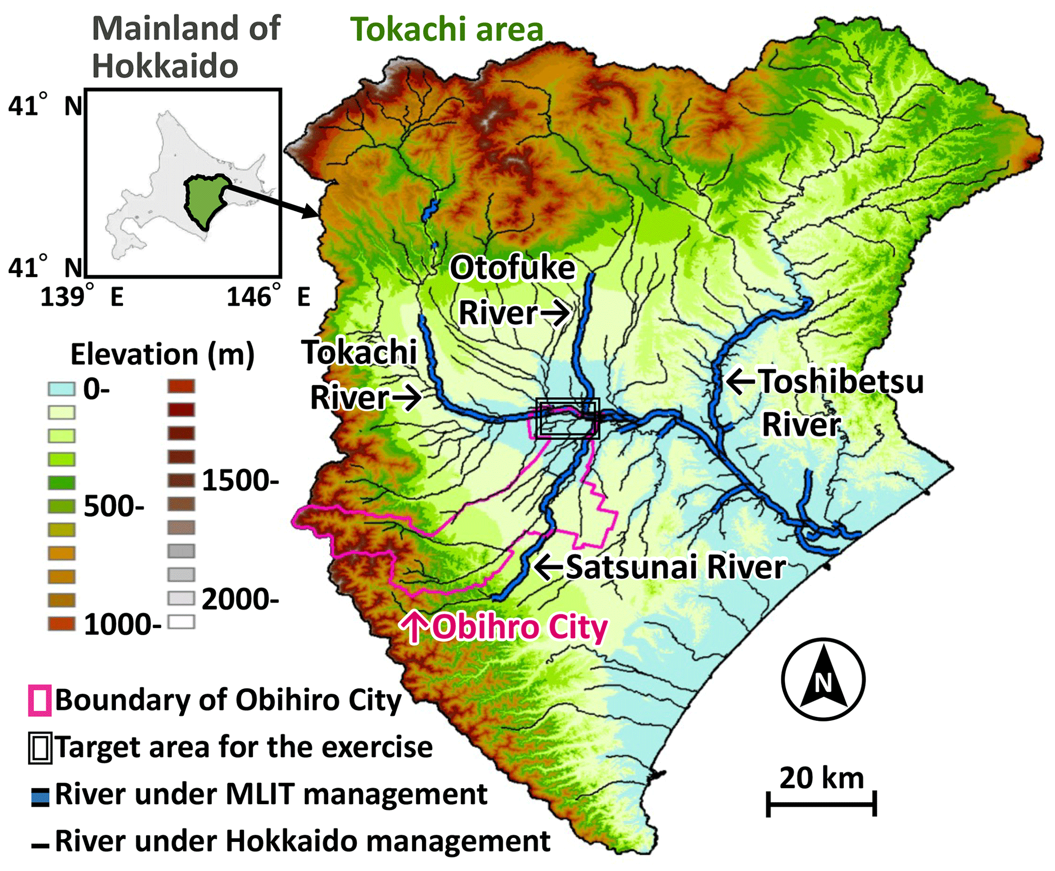
Figure 1Elevation of Tokachi Subprefecture, river channels, and the location of the target area for the exercise method. (The elevation and river line data was provided by the Geospatial Information Authority of Japan).
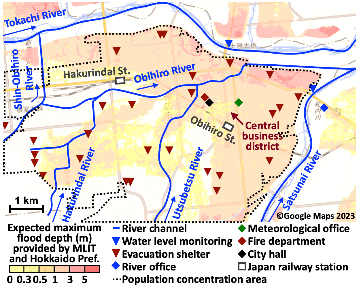
Figure 2The target area includes information on maximum expected flood depths, river channels, water level monitoring points, flood evacuation shelters, key public facilities, and areas with high population concentration.
We discussed emergency response with municipalities using flood scenarios targeted at big rivers under future climate conditions, as calculated by Yamada (2019). As a result, it was suggested that municipalities are also concerned about flooding of small rivers, and that to consider evacuation information at specific times and areas, disaster-related information, such as warnings, is necessary (Suzuki et al., 2022). The objective of this study is to develop a disaster resilience method for potential future flood disasters. We proposed a method for making flood scenarios, which encompass small river flooding, based on climate projections. Additionally, we developed an exercise method for municipalities to contemplate the issuance of evacuation information, utilizing these scenarios to enhance their preparedness and gain practical experience. The detailed procedures for conducting such exercises based on this method have been outlined in Suzuki et al. (2023). Furthermore, we conducted a simulation exercise using this method in a demonstration experiment in Hokkaido, Japan. In this paper, besides explaining these methods, we elaborate on the results of the simulation exercise and discuss the outcomes achieved, along with the challenges and further utilization ideas.
2.1 Target area
The target area for the simulation exercises was Obihiro City, in Tokachi Subprefecture, Hokkaido, and with the largest population in the subprefecture. Figure 1 shows the elevation and class A river channels, along with the target area. The city is located between 2 big rivers the Tokachi River, flowing on the north side, and the Satsunai River, flowing on the east side. Figure 2 shows the target area along with the maximum expected flood depth simulated by MLIT. It also marks river channels, water level monitoring point, flood evacuation shelters, key public facilities, and the population concentration areas. The population concentration areas, defined by the Ministry of Internal Affairs and Communications, have a population density of over 4000 people per square kilometer, including adjacent areas, with a combined population exceeding 5000. Due to the high risk of significant flooding in the city's core, there is substantial flooding risk
2.2 Data
To make potential future flood scenarios we used 5 km spatial resolution rainfall data under future climate conditions, with an average global temperature increase of 4° compared to pre-1850, from the Database for Policy Decision Making for Future Climate Change (d4PDF) (Kawase, 2023). This meteorological dataset contains thousands of years of past and future climate conditions, enabling the statistical inference of the intensity and frequency of extreme weather events (Mizuta et al., 2017; Yamada et al., 2021).
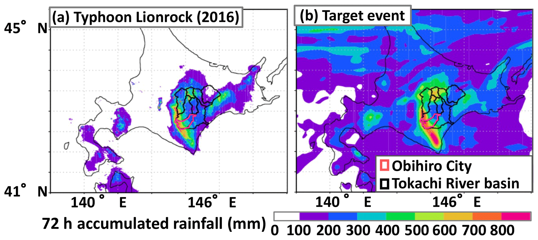
Figure 3Peak rainfall amount over Tokachi River basin for 72 h in the target event and rainfall caused by Typhoon Lionrock (2016), and the location of the basin and Obihro City.
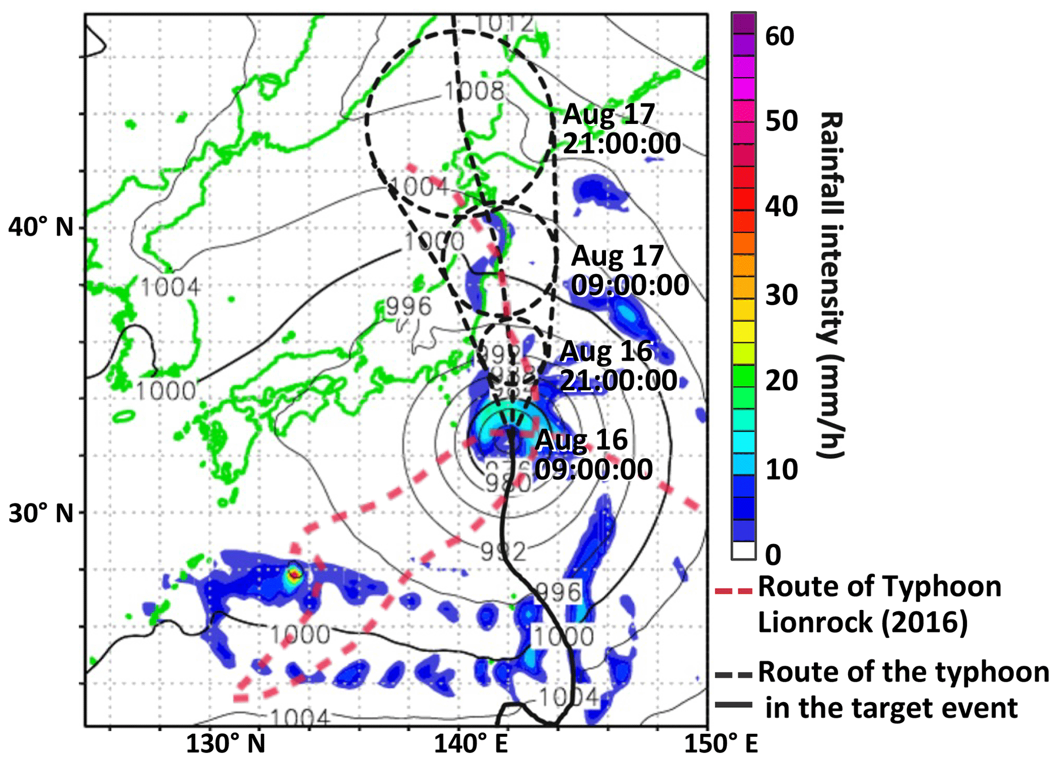
Figure 4The routes of Typhoon Lionrock (2016) and the typhoon in the target rainfall event and sea-surface pressure in a weather report provided at start of the exercise method.
We selected a rainfall event with a route similar to that of Typhoon Lionrock (2016) and a spatial distribution of rainfall, but the scale of rainfall is greater. Figure 3 shows the peak rainfall amount over the basin for 72 h in the target rainfall event and rainfall caused by Typhoon Lionrock. The peak rainfall amount for the selected event is almost 1.5 times greater than that of Typhoon Lionrock. In Fig. 4, the route of the typhoon in the target rainfall event and the Typhoon Lionrock of 2016. In the d4PDF dataset, historical experiments spanning 3000 years identified 37 typhoons have similar route to Typhoon Lionrock, and in future experiments covering 5400 years, 64 case were found. This “similar route” is defined, following Hoshino et al. (2020), as typhoon with path around the Tohoku region (35–40° N) deviating by no more than 1° in longitude from Typhoon Lionrock's route. Typhoons approaching and making landfall in Hokkaido from the Pacific Ocean generally exhibit less pressure drop, increasing the likelihood of significant rainfall, a concern by municipal officials (Kitano et al., 2017).
2.3 Potential future flood scenario
The flood scenario is composed of rainfall intensity, river water level, and flood depth data at a 1 h resolution. The target rivers include large rivers managed by MLIT (the Tokachi, Satsunai Rivers) as well as relativity small rivers managed by Hokkaido Prefecture (the Hakurindai, Utsubetsu, Obihiro, and Shin-Obihiro Rivers), as shown in Fig. 2. For the rivers managed by MLIT, where survey and observation are well-developed, we calculated water level and flood depth based on the storage function method, kinematic wave model, and two-dimensional plane flow analysis (Yamada, 2019). For the rivers managed by Hokkaido, we calculated flood depth based on the two-dimensional plane flow analysis using the Nays2DFlood solver of the International River Interface Cooperative (iRIC) software, which allows for the unified analysis of river channels and floodplains (Shimizu, 2014). These two methods are employed for rivers managed by MLIT and Hokkaido for calculating the expected maximum flood depth, which is utilized in the creation of flood hazard maps for municipalities. The calculation model was provided by the MLIT, and it was developed in accordance with a manual for calculating the expected maximum flood depth (National Institute for Land and Infrastructure Management, 2017). The flood depth for the flood scenario is obtained by superimposing the maximum flooding depth of the target rivers at the same time.
Please note that all times listed in this paper are in Japan Standard Time (JST). Also, in the d4PDF for future climate conditions, the year number has no meaning and is not described. Figure 5 shows the river water level at the monitoring points as shown in Fig. 2 ,of the Tokachi and Satsunai Rivers. As shown in Fig. 5, the water level of the two rivers began to rise around 16 August at 18:00:00. Additionally, water-level criteria are shown in Fig. 5, that is equivalent to Alert Level that is a reference for issuing evacuation information as bellow. Alert Level 1: Criterion for Flood-Fighting Standby; Level 2: Advisory Water Level; Level 3: Evacuation-Warning Water Level (reference criterion for Evacuation of the Elderly, etc.); Level 4: Hazardous Water Level (reference criterion for Evacuation Instruction); High Water Level (HWL): Water levels increase to this level when the designed-maximum flow rate occurs. It is an index of flooding, although river levees are generally designed higher than this level.
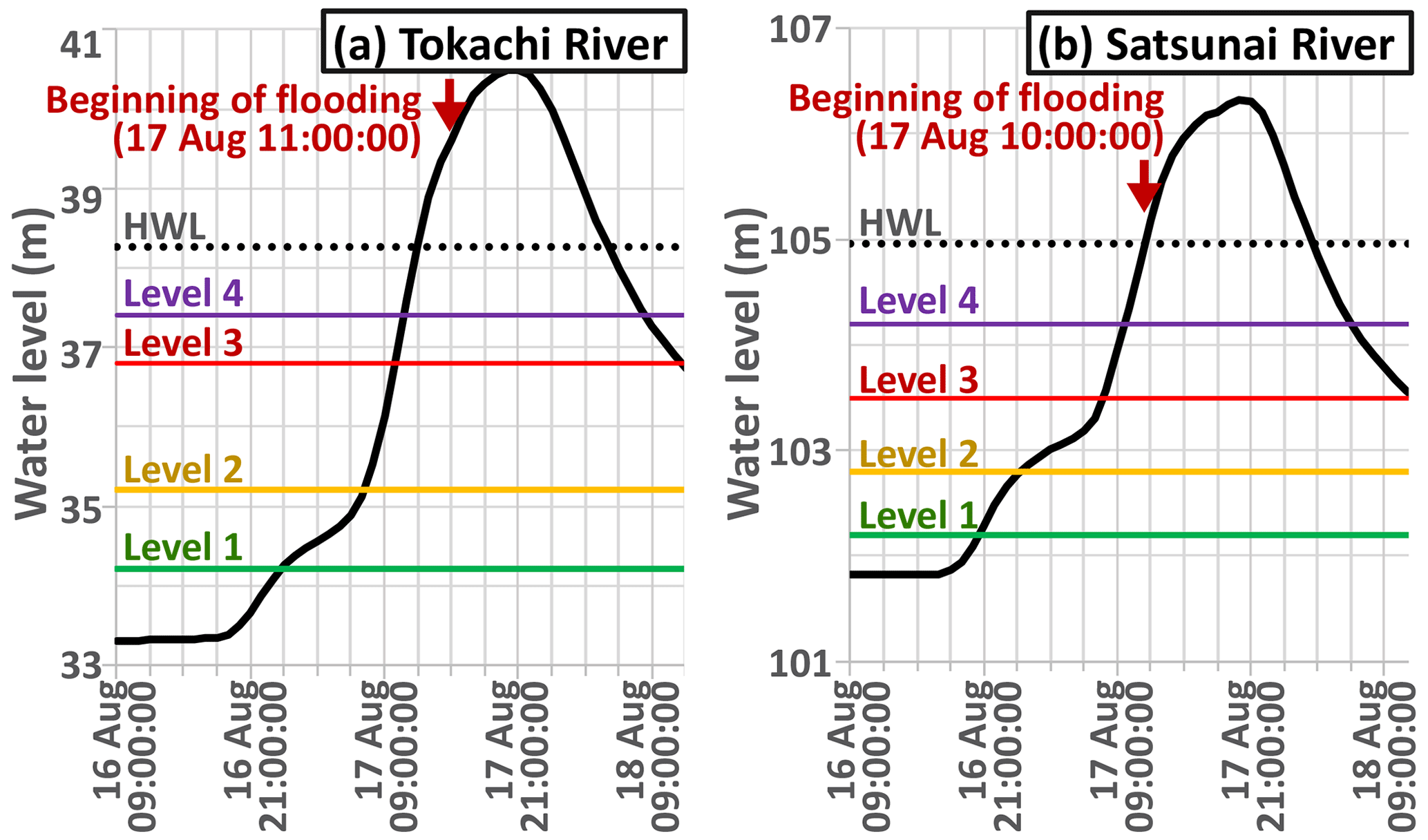
Figure 5Water levels, and the water-level criteria of Tokachi and Satsunai Rivers at the monitoring point.
Figure 6 illustrates flood depths in the target area, corresponding to Fig. 2. In this scenario, around 06:00 on 17 August, small to medium-sized rivers (Hakurinndai, Utsubetsu, Obihiro Rivers) flowing through the city's core rapidly overflowed, followed by the larger Satsunai River. The inundation area resembles the expected maximum flood shown in Fig. 2. However, as the expected maximum flood is a superposition of potential inundation areas, the scenario's inundation area is relatively smaller.
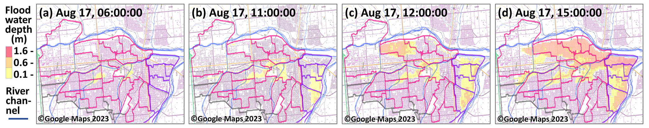
Figure 6Flood depth at the onset of flooding of each river and the areas around the Satsunai (purple lines) and Utsubetsu Rivers (pink lines) considered for issuing evacuation information in the demonstration experiment.
2.4 Exercise method
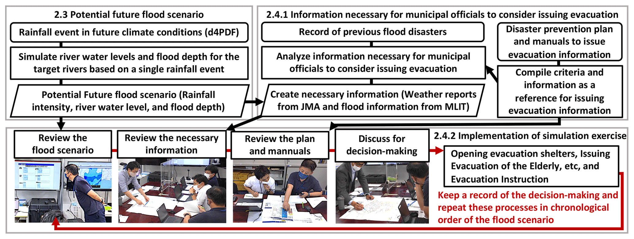
Figure 7 shows the flowchart of the proposed method. We summarized the method for implementing simulation exercises for municipality to consider issuing evacuation information for the flood scenarios that will potentially occur in future climate conditions. In preparing for the simulation exercise, we analyzed and created the necessary information to assist the officials in imaging the situation and making decisions on issuing evacuation information for an unprecedented scale and pattern of flood disaster (namely, using the potential future flood scenarios).
2.4.1 Information necessary for decision-making
First, we compiled the municipal disaster-prevention plan and the manuals for issuing evacuation information to determine the criteria used as a reference for decision-making on issuing evacuation information. The criteria are detailed below: (1) Heavy Rain Advisory and Warning announced by the Japan Meteorological Agency (JMA), (2) Water level criteria of the rivers, and (3) Flood Advisory and Warning announced by MLIT, which are determined based on observations and forecasts of the water levels. These advisories are equivalent to Level 2 of Alert Level, and the warnings are equivalent to Level 3.
Next, using a method for organizing events and information among a disaster chronologically as Seki et al. (2016), we compiled a chronological table containing all the disaster-related information provided to Obihiro City and decision-making of the municipality during Typhoon Lionrock (2016), based on the disaster reports provided by MLIT. In consultation with the municipality and the river office of MLIT using the chronological table, we identify the information necessary for decision-making on issuing evacuation information. The necessary information is as follows: (1) Weather reports provided by JMA, which include sea-surface pressure, typhoon route, accumulated rainfall at observation points from the typhoon approached, forecasted daily rainfall over the region for the next 1–2 d, and Heavy Rain Advisory and Warning based on forecasted rainfall up to 6 h in advance. (2) Water level information that reaches the criteria, as well as Flood Advisory and Warning based on forecasted river water levels up to 6 h in advance, and are provided by MLIT.
Finally, we created the necessary information based on the flood scenario for the simulation exercise.
2.4.2 Implementation of simulation exercise
We set the period of the flood scenario for the simulation exercise from 09:00:00 on 16 August, a few days before the typhoon reached Hokkaido, to 21:00:00 on 17 August, when the inundation area is at its maximum. The figure suggests that the typhoon is strong, with a sea-surface pressure of 970 hPa at its center, and it is forecasted to reach Hokkaido in a few days. Figure 4 shows the sea-surface pressure and the typhoon's route in the weather report provided at the beginning of the simulation exercise.
In this exercise method, the scenario time is advanced by the hour. The flood scenario and the information necessary for decision-making on issuing evacuation information are provided to the officials corresponding to the scenario time. Then, the officials consult the disaster prevention plan and manuals for issuing evacuation information. They decide on specific areas and the level of evacuation information, which may include emergency response measures such as opening evacuation shelters and deploying patrols. Furthermore, they discuss the rationale for these decisions. Finally, they repeat all the processes in chronological order of the scenario. The flood scenario is visualized in the same format as during an actual disaster. Rainfall intensity is provided as the forecast by JMA up to 6 h in advance, river water levels are provided as the observation by MLIT, and flood depth is provided as the forecast by the Integrated Disaster Response Support System for Municipalities (IDR4M) up to 6 h in advance. IDR4M is a system that forecasts flooding risk based on machine learning and physical forecasts (Mitani, 2021). At Obihiro City, IDR4M provides trial forecasts of flooding for the demonstration experiment.
The results of a simulation exercise based on the proposed method with the municipal officials of Obihiro City are presented as follows. The decision-making and the rationale on issuing evacuation information are detailed.
(1) On 16 August at 09:00:00, the prevention officials based on forecasted typhoon route, approaching Hokkaido, and large amount of daily rainfall in the first weather report notified all relevant agencies about the possibility of patrols deployment and opening evacuation shelters. (2) At 15:00:00, the officials initiated the opening evacuation shelters throughout the city to avoid opening the shelters at night. Voluntary Evacuation Advisory was issued for the areas around the Satsunai River bounded by purple lines in Fig. 6 after opening the shelters, because the daily rainfall forecast was a potentially record-breaking amount, according to a weather report. (3) At 18:00:00, the officials deployed patrols because the water levels of the Satsunai River exceeded Level 1 (criterion (2) in Sect. 2.3.1). (4) On 17 August at 00:00:00, the officials issued an Evacuation of Elderly, etc. for the area around the Hakurindai, Utsubetsu, and Obihiro Rivers bounded by pink lines in Fig. 4, because Heavy Rainfall Warning (criterion (1) in Sect. 2.3.1) was announced and flooding was forecasted in 6 h by IDR4M. The area for Evacuation of Elderly, etc. was expanded because of Flood Warning (criterion (3) in Sect. 2.3.1) for the Tokachi River and a heavy rainfall was predicted in the upstream part of the river based on rainfall data. Moreover, flooding within a few hours was a subject of concern Evacuation of Elderly, etc. was issued for the area bounded by purple lines in Fig. 4. (5) At 05:00:00, the officials issued Evacuation Instruction for the area bounded by pink lines in Fig. 4 because the river water levels of the Hakurindai and Utsubetsu Rivers exceeded Level 4. Moreover, Evacuation Instruction was issued for the area bounded by purple lines in Fig. 4 because the water level was rising rapidly and Flood Warning was announced.
Based on the post-simulation exercise review, we describe achievements of this method. Furthermore, we will discuss the challenges and further utilization ideas.
4.1 Achievements
In the simulation exercise, prevention officials gained valuable experience and insight. Initially, officials believed that Satsunai River would experience flooding based on their past experiences and the forecasted daily rainfall. However, sudden overflows occurred in smaller rivers like Hakurindai River in this flood scenario, giving them new insights into these flooding patterns. During the simulation exercise, the flood scenario and necessary information were presented in the same format and were as comprehensive as in an actual disaster, enabling officials to compare it with established criteria and manuals. This facilitated decision-making regarding the issuance of evacuation information for specific areas and times. Additionally, longer-term forecast information, such as weather reports, allowed for considerations not only in the immediate decision-making before a flood but also for the early opening of evacuation shelters and flood-fighting activities, including the deployment of patrols.
4.2 Challenges
4.2.1 Enhancement of model accuracy
Current flood analysis models, similar to the models used in the creation of maximum expected inundation depth maps employed in the development of flood hazard maps, do not incorporate the influence of elevated water levels at confluence points downstream. Furthermore, the effects of inland flooding, including runoff from sewage systems, have not been considered. These factors may result in accuracy issues in the calculation results.
4.2.2 Multi-hazard scenario incorporation
In actual emergencies during heavy rainfall, municipalities must respond not only to river-based floods but also to sediment disasters. However, the current scenarios only consider river-based floods and do not encompass other types of hazards. Therefore, to avoid underestimating the necessary responses during emergencies, it is necessary to encompass the various types of hazards caused by rainfall.
4.2.3 Approximation to actual disaster conditions
Municipalities rely on consultations with the JMA observatory and MLIT river offices, as well as reports from citizens, as key sources of information for emergency decision-making. To better reflect real conditions, additional situational information and participation of related organizations are effective.
4.2.4 Scenario selection and prioritization
Comprehensive preparation for future floods requires exercises involving numerous heavy rainfall scenarios. However, conducting these exercises is impractical due to extensive procedures, including scenario creation, coordination with municipalities for simulation training, and prioritization of representative scenarios. Addressing this challenge involves selecting a subset of critical scenarios that must be experienced at least and evaluating the effective order for simulation exercises.
4.3 Further utilization ideas
4.3.1 Expanding for residents and companies
In the “River Basin Disaster Resilience and Sustainability for All” project, it is crucial that all stakeholders within the basin contribute to mitigation efforts. To enhance disaster resilience, residents and companies must actively prepare on a daily basis and respond appropriately in emergency. Our method has the potential to support them in creating emergency plans, gaining practical experience, and enhancing their preparedness. However, it is necessary to understand that key actions for them during emergency response (e.g., issuance of evacuation information by municipalities) and the necessary information for decision-making (e.g., weather and river warnings for municipalities) are essential. Furthermore, developing methods of exercises to simulate as actual emergency for them is equally important.
4.3.2 Testing new forecast and disaster information
Testing new forecasting and support information for municipal decision-making during the trial phase usually involves assuming past disaster events. In our method, there is the potential to assess the impact of this new information on future floods within the context of real emergency situations, including currently available forecasts and disaster-related information. Additionally, it can contribute to exploring the optimal integration of new information with existing data and determining when to utilize it in emergency decision-making, all from the perspective of information recipients.
In this study, to enhance disaster resilience against potential future flood disasters, we proposed a method to make flood scenarios based on climate projections, considering the risk of flooding in small rivers. Focusing on the information necessary for decision-making on issuing evacuation information, we also developed an exercise method for municipalities using the flood scenarios. Moreover, we conducted a simulation exercise with municipal officials in Hokkaido using this method. As a result, issuing evacuation information for specific areas and times and providing valuable insights, including knowledge of new flooding patterns and disaster prevention issues, were achieved, thereby enhancing preparedness for potential future flood disasters. Furthermore, we discussed the challenges in applying this method to municipal disaster prevention strategies and explored additional ways to utilize it in the future.
The software code and research data supporting the findings of this study were developed through collaborative efforts with local municipalities and administrations. Due to the nature of this partnership, public disclosure poses significant challenges. As a result, the software code and research data are not publicly available at this time. However, in cases where there is a recognized need and an agreement has been reached with relevant stakeholders, access to the software code and research data can be facilitated by the corresponding author, Akihiro Suzuki.
AS: Conceptualization; data curation; formal analysis; investigation; methodology; project administration; software; validation; visualization; writing – original draft; writing-review & editing. FU: Data curation; formal analysis; investigation; software; visualization. TH: Data curation; formal analysis; investigation; software; visualization. TY: Project administration. TJY: Conceptualization; data curation; funding acquisition; methodology; project administration; resources; software; supervision; validation; writing – original draft; writing-review & editing.
The contact author has declared that none of the authors has any competing interests.
Publisher’s note: Copernicus Publications remains neutral with regard to jurisdictional claims made in the text, published maps, institutional affiliations, or any other geographical representation in this paper. While Copernicus Publications makes every effort to include appropriate place names, the final responsibility lies with the authors.
This article is part of the special issue “ICFM9 – River Basin Disaster Resilience and Sustainability by All”. It is a result of The 9th International Conference on Flood Management, Tsukuba, Japan, 18–22 February 2023.
This study is supported by the Council for Science, Technology and Innovation (CSTI), Cross-ministerial Strategic Innovation Promotion Program (SIP), Development of a Resilient Smart Network System against Natural Disasters, with funding provided by the National Research Institute for Earth Science and Disaster Resilience (NIED), and The Advanced Studies of Climate Change Projection (SENTAN) Grant Number JPMXD0722680734 from the Ministry of Education, Culture, Sports, Science, and Technology (MEXT), Japan.
The utilization of d4PDF in this study was made possible through collaboration with the Earth Simulator and its associated science programs (SOUSEI, TOUGOU, SI-CAT, DIAS) of MEXT, Japan.
The Crisis Management Section of the City of Obihiro, Hokkaido, provided valuable cooperation during the empirical experiments in this study.
The Ministry of Land, Infrastructure, Transport and Tourism, Japan, supported the development of rainfall runoff and inundation calculation models for flood scenarios by providing observation data and software code.
Flood analysis in small rivers was conducted using the Nays2DFlood solver of the International River Interface Cooperative (iRIC) software.
This research has been supported by the Japan Society for the Promotion of Science (grant no. 22H01594) and the Ministry of Education, Culture, Sports, Science and Technology (grant no. JPMXD0722680734).
This paper was edited by Daisuke HARADA and reviewed by two anonymous referees.
Hoshino, T., Okachi, H., Takehara, Y., and Yamada, T. J.: Evaluation of heavy rainfall risk of typhoon hagibis (2019) associated with typhoon track, J. Jpn. Soc. Civ. Eng. Ser. B1, 76, 414–423, https://doi.org/10.2208/journalofjsce.10.1_534, 2020.
Kawase, H.: Dynamical downscaling ensemble data covering the whole Japan from d4PDF with 5-km nonhydrostatic regional climate model (NHRCM), Data Integration and Analysis System (DIAS) [data set], https://doi.org/10.20783/DIAS.657, 2023.
Kitano, Y., Yamamoto, T., Kobayashi, A., and Yamada, T. J.: Statistical analysis of typhoon related events in Hokkaido and surroundings in the last 56 years including the 2016 heavy rainfall, J. Jpn. Soc. Civ. Eng. Ser. B1, 73, 4, 1231–1236, https://doi.org/10.2208/jscejhe.73.I_1231, 2017 (in Japanese).
Koike, T.: Evolution of Japan's flood control planning and policy in response to climate change risks and social changes, Water Policy, 23, 77–84, https://doi.org/10.2166/wp.2021.287, 2021.
Mitani, Y.: Development of innovative technology for new disaster prevention information system, J. Struct. Mater. Civ. Eng., 37, 21–27, 2021 (in Japanese).
Mizuta, R., Murata, A., Ishii, M., Shiogama, H., Hibino, K., Mori, N., Arakawa, O., Imada, Y., Yoshida, K., Aoyagi, T., Kawase, H., Mori, M., Okada, Y., Shimura, T., Nagatomo, T., Ikeda, M., Endo, H., Nosaka, M., Arai, M., Takahashi, C., Tanaka, K., Takemi, T., Tachikawa, Y., Temur, K., Kamae, Y., Watanabe, M., Sasaki, H., Kitoh, A., Takayabu, I., Nakakita, E., and Kimoto, M.: Over 5,000 years of ensemble future climate simulations by 60-km global and 20-km regional atmospheric models, Bull. Amer. Meteor., 98, 1383–1398, https://doi.org/10.1175/BAMS-D-16-0099.1, 2017.
National Institute for Land and Infrastructure Management: Manual for Creating Flood Inundation Assumed Area. 4th edn., 2017.
Sato, S., Hayashi, H. Tamura, K., and Urata, Y.: Lessons and Issues Learned from Emergency Response of the 2009 HeavyRain – TRENDREADER Analysis of Open Ended Answer Data in “Survey of Municipal Governments Published Evacuation Advisory and Order”, J. Jpn. Soc. Nat. Disaster Sci., 30, 123–145, 2011 (in Japanese).
Seki, K., Wakigawa, K., and Okayasu, T.: Study on the decision-making system for effective evacuation during flood events, Adv. River Eng., 22, 362–366, https://doi.org/10.11532/river.22.0_361, 2016 (in Japanese).
Shimizu, Y.: iRIC Software Nays-2D Flood Solver Manual, https://i-ric.org/solvers/nays2dflood/ (last access: 5 November 2020), 2014 (in Japanese).
Suzuki, A., Yamada, T. J., Yamamoto, T., and Uemura, F.: Efforts toward evacuation decision making and prior learning using ensemble climate information in Tokachi River basin, Hokkaido, Proc Jpn. Soc. Civ. Eng., Hokkaido Blanch 2022 Annual Meeting, 2022 (in Japanese).
Suzuki, A., Uemura, F., Hoshino, T., Ishihara, M., Yamamoto, T., Hashimoto, S., and Yamada, T. J.: A method for municipality to plan issuing evacuation information for flood risk considering impact of the climate change, J. Jpn. Soc. Civ. Eng. Ser. G, 79, 23-27045, https://doi.org/10.2208/jscejj.23-27045, 2023 (in Japanese).
Yamada, T. J.: A Case Study: Adaptation Measures for Extreme Floods in Japan, Using Huge Ensemble of High-resolution Climate Model Simulation, United Nations Framework Convention on Climate Change, Bonn, Germany, 28–30, https://unfccc.int/documents/196569 (last access: 1 December 2023), 2019.
Yamada, T. J., Hoshino, T., and Suzuki, A.: Using a massive high-resolution ensemble climate data set to examine dynamic and thermodynamic aspects of heavy precipitation change, Atmos. Sci. Lett., 22, e1065, https://doi.org/10.1002/asl.1065, 2021.