the Creative Commons Attribution 4.0 License.
the Creative Commons Attribution 4.0 License.
 | 19 Apr 2024
Comparison of one-site vs. multi-sites calibration schemes for hydrological modelling of nested catchments in the West African Sahel
Yetchékpo Patrick Gbohoui
Roland Yonaba
Tazen Fowé
Bernadin Elégbédé Manou
Taofic Bacharou
Yvon-Carmen Hountondji
Ernest Amoussou
Luc O. Sintondji
Jean-Emmanuel Paturel
Harouna Karambiri
Hamma Yacouba
Runoff simulation in highly anthropized catchments is complex, but essential for water management, especially in poorly gauged and data-scarce hydrosystems of the West African Sahel. This study aims to evaluate the effect of different calibration schemes on runoff simulation. The physically-based and semi-distributed hydrological SWAT (Soil and Water Assessment Tool) model is used to simulate daily runoff in the Nakanbé catchment at Wayen station in Burkina Faso (in the West African Sahel) over the period 2006–2012. Four (4) hydrometric stations (Dombré, Rambo, Ramsa and Wayen) gauging 4 nested catchments (ranging from 1060 to 21 178 km2 in size) are considered. The added value of the consideration of nested catchments is assessed through the following 3 calibration schemes: one-site (OS) at the entire catchment outlet (Wayen); multi-sites with nested sub-catchments (MS1); and multi-sites without considering nested sub-catchments (MS2). The results indicate that OS and MS2 schemes perform well (KGE > 0.7, |PBIAS %), with MS2 scheme being superior (KGE, PBIAS). However, the MS1 scheme (KGE = 0.68; PBIAS = −22.9 %) performed worse in comparison to the traditional OS scheme. The comparison of the three modelling schemes provides evidence that accounting for nested sub-catchments does not necessarily improve the quality of rainfall-runoff simulations. Yet, multi-site calibration should be favoured when catchments are not nested.
- Article
(1143 KB) - Full-text XML
- BibTeX
- EndNote


UPH6; Modelling; Nested catchments; Sahel
The combined effects of climate and environmental changes increase the complexity of runoff modelling. In highly anthropized catchments, for example, natural hydrological behaviour is altered, affecting the ability of hydrological models to simulate runoff, especially if detailed and accurate data is not available (Zhang et al., 2013; Abbaspour, 2015; Zanin et al., 2018). Physically-based and distributed/semi-distributed models are known to be suitable for rainfall-runoff modelling in such contexts (Zanin et al., 2018). However, these models generally involve large number of parameters. The calibration of distributed/semi-distributed and physically-based models remains a challenging task.
Calibration is usually performed at the outlet of a single catchment and does not always represents the hydrological processes in the different river sub-catchments (Zanin et al., 2018). Multi-sites/multi-variables calibration approaches are therefore often applied to obtain realistic optimized parameter values (Cao et al., 2006; Zanin et al., 2018). These approaches often improve the simulation performance of hydrological models.
The Soil and Water Assessment Tool (SWAT, https://swat.tamu.edu/, last access: 13 October 2023) model is a physically-based and semi-distributed agro-hydrological modelling tool that allows the implementation of multi-sites modelling. The SWAT model is widely applied around the world and in Africa (Tan et al., 2020; Akoko et al., 2021).
The West African Sahel is known for the fragility of its hydrological system, for which a wide range of questions remains unsolved (Blöschl et al., 2019). Indeed, the hydrological behaviour of some West African Sahel catchments has been strongly affected by global change (Descroix et al., 2018; Gbohoui et al., 2021; Yonaba et al., 2021a). Volta is one of the most important rivers in West African and has its source in the Sahelian part of Burkina Faso (Nakanbé River). The Volta catchment is highly anthropized and shelters several dams for hydroelectric or agricultural purposes. Previous studies on modelling the runoffs of this river were mainly devoted to its downstream outlets (Schuol et al., 2008; Sood et al., 2013; Poméon et al., 2018). Furthermore, these studies did not analyse the effects of considering nested or non-nested catchments in the multi-sites modelling process.
This study focuses on the headwater sub-catchments and the Wayen station, whose gauged catchments covers the entire Sahelian part of the Volta catchment. It aims to assess various calibration schemes, namely one-site calibration (OS, at the entire catchment outlet) and different multi-sites (MS) calibration schemes using the SWAT model and 4 nested catchments (ranging in size from 1060 to 21 178 km2) in the West African Sahel.
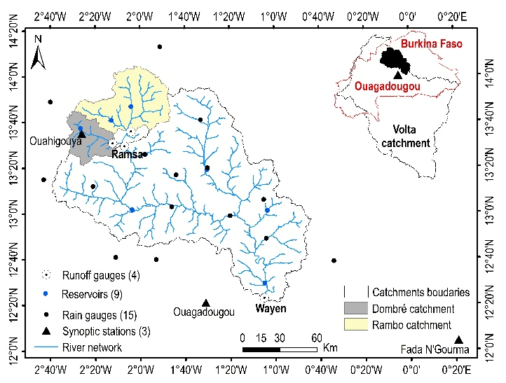
Figure 1Study area (headwater catchments of the White Volta) with drainage network, reservoirs, synoptic stations, rain gauges and runoff gauges (data source: IGB and DGRE).
2.1 Study area
The study area covers the headwater sub-catchment of the Nakanbé, located between 0°40′ and 2°40′ W longitudes and 12°20′ and 14°00′ N latitudes. The relief of the catchment is generally flat with an extremely low average longitudinal slope (Slope <0.2 %).
The study area (Fig. 1) is a combination of four nested catchments: Rambo (2471 km2), Dombré (1060 km2), Ramsa (3826 km2), and Wayen (21 178 km2). The Rambo and Dombré sub-catchments are nested within the Ramsa sub-catchment, while Ramsa itself lies within the larger Wayen catchment. The Wayen catchment shelters several natural and artificial reservoirs of various sizes, the most important of which are shown in Fig. 1.
2.2 Data
2.2.1 Hydrometeorological data
To evaluate the OS and MS calibrations, 4 hydrometric stations (runoff gauges) are selected: Rambo, Dombré, Ramsa and Wayen (whose location is presented in Fig. 1). The daily runoff data available at these stations covers the period 1965–2018. These stations were operational at different dates and their records are filled with several gaps. Therefore, a common gap-free period for the 4 runoff gauges is used in this study, which is the period 2006–2012. The data was obtained from a national agency (in French, “Direction Générale des Ressources en Eau”, DGRE) in Burkina Faso.
The characteristics of the 9 main reservoirs (shown in Fig. 1) in the catchment were obtained from the DGRE. Water withdrawals data at Ziga dam (close to Wayen runoff gauge in Fig. 1) was provided by the national office in charge of water and sanitation (in French “Office National de l'Eau et de l'Assainissement”, ONEA) in Burkina Faso.
The meteorological data for the period 2006–2012 were provided at the daily time step and included precipitation, temperature (minimum and maximum), solar radiation, wind speed, and relative humidity. The data was collected from the national meteorology agency (ANAM-BF) in Burkina Faso for 15 rain gauges and 3 synoptic stations (Fig. 1).
2.2.2 Ancillary data
The Digital Elevation Model (DEM) was downloaded from the Japan Aerospace Exploration Agency (JAXA) website (https://www.eorc.jaxa.jp/ALOS/en/aw3d30/index.htm, last access: 30 June 2022). It has a spatial resolution of 30 m × 30 m.
The Food and Agriculture Organization (FAO) digital soil map (http://www.fao.org/soils-portal/soil-survey/cartes-historiques-et-bases-de-donnees-des-sols/carte-faounesco-des-sols-du-monde/fr/, last access: 30 June 2022) was used to generate the soil data needed for SWAT. In terms of hydraulic characteristics, the catchment basements are crystalline, which limits infiltration.

Figure 2Land use and land cover map (data source: DGRE). RNGE, AGRL, BARR and WATR are identification codes for the LULC types implemented in SWAT.
The land use and land cover (LULC) data were obtained from the national geography institute (in French, “Institut Géographique du Burkina”, IGB), and was further reclassified into 4 units: water, bare soil, cultivated areas and vegetation (Fig. 2). These units were deemed reliable to cover the variability and physical processes in Sahelian landscapes (Yonaba et al., 2021b; Paturel et al., 2016).
2.3 Model setup
The model setup is carried out through the ArcSWAT 2012.10_5.21 interface. SWAT simulates hydrology at the scale of element areas known as Hydrological Response Units (HRUs). HRUs are created from the overlay of sub-catchment contours, LULC units, soil types, and slope classes. The model outputs are estimated at the HRU scale and summed up to obtain processes outputs at the sub-catchment scale, further routed at the entire catchment outlet (Neitsch et al., 2011).
Surface runoff is simulated through the Soil Conservation Service (SCS) Curve Number (CN) method, and the Muskingum method is further used for routing through the channel network system. Potential evapotranspiration is estimated through the Penman–Monteith formula.
In this study, the model was set up over the period 1965–2018 with a warm-up period of 3 years (1965–1968). The common data period (2006–2012) for the 4 runoff gauges is used to implement the modelling schemes.
2.4 Model calibration and validation
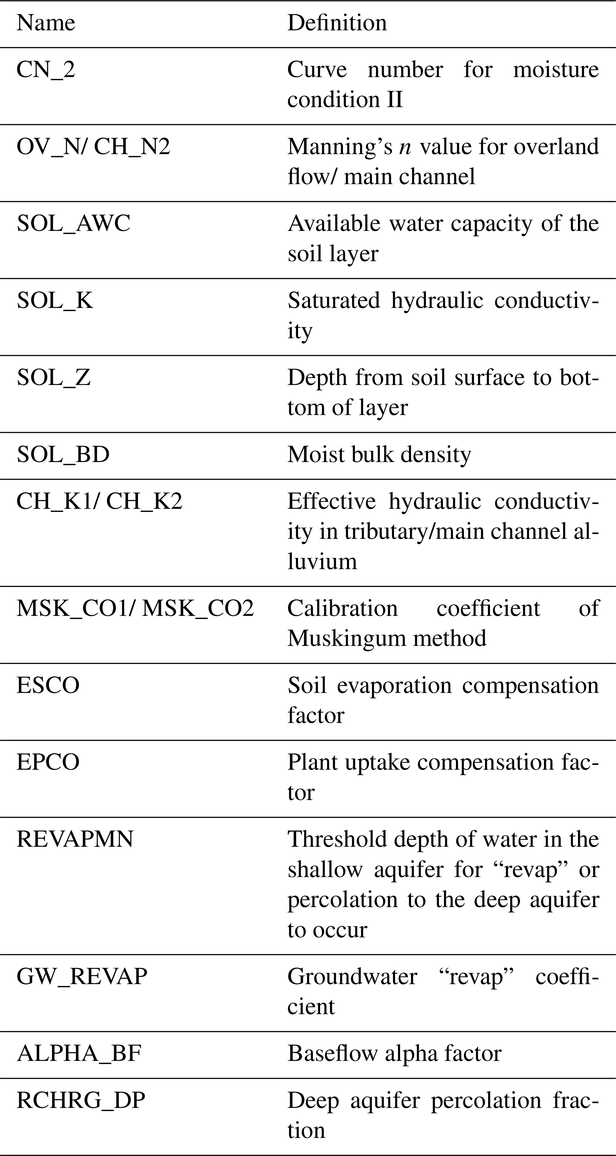
Based on a literature review of SWAT model applications in West African Sahel (Schuol et al., 2008; Sood et al., 2013; Adjei et al., 2015; Awotwi et al., 2015; Akpoti et al., 2016; Poméon et al., 2018; Yonaba et al., 2021a), a set of 33 parameters is initially screened for sensitivity analysis Thus, 17 parameters (presented in Table 1) were selected and considered for calibration and validation.
The calibration/validation process was performed under SWAT-CUP with the Sequential Uncertainty Fitting (SUFI2) algorithm, which combines optimization and uncertainty analysis (Abbaspour, 2015). The objective function used was the Kling-Gupta Efficiency (KGE) criterion with an acceptability threshold of 0.5 (Thiemig et al., 2013). The under/overestimation of the model was assessed with the bias percentage (PBIAS) criterion. These criteria were defined in the SWAT-CUP user manual (Abbaspour, 2015).
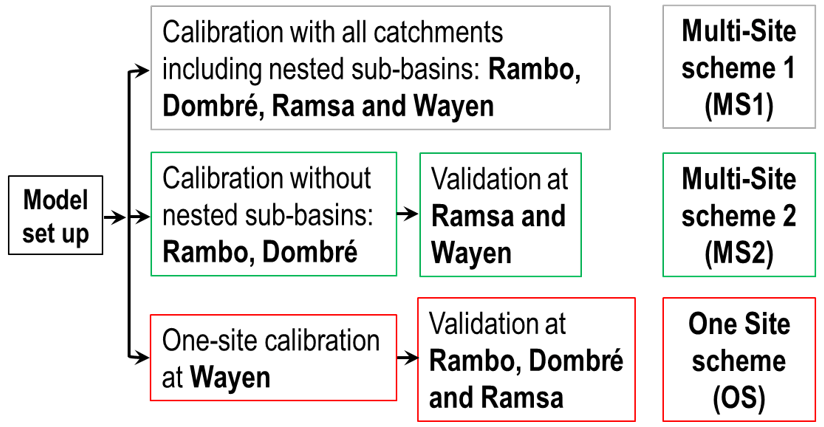
The effects of multi-sites modelling compared to traditional modelling at the catchment outlet are evaluated through three schemes presented in Fig. 3: one-site (OS) at the entire catchment outlet (Wayen); multi-sites calibration with nested sub-catchments (MS1) and multi-sites without nested sub-catchments (MS2). The modelling process in SWAT is carried out through successive iterations. In this study, each modelling scheme consisted of 3 iterations of 500 simulations: 2 iterations for parameters calibration et 1 iteration for runoff simulation.
A comparative study of the results of the three modelling schemes allowed us to evaluate the effects of the one-site and the different multi-sites schemes on surface runoff simulation at the Wayen outlet. The results of the MS1 scheme (including nested catchments) compared to those of the MS2 scheme (non-nested catchments) allowed us to assess the consideration of the upstream-downstream hydraulic connections between nested catchments in the calibration process.
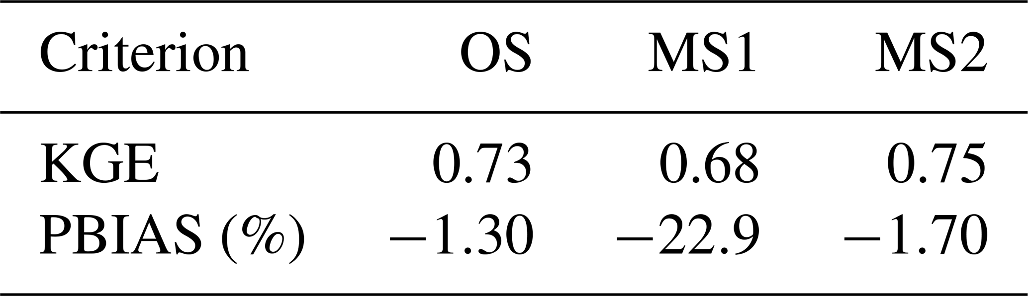
Table 2Performance of the three modelling schemes at Wayen outlet.
3.1 One-Site vs. Multi-Sites (nested or not) modelling
The performance of the different modelling schemes for the Wayen runoff gauge is shown in Table 2. Further details on the simulation results can be found in Gbohoui (2021).
The results indicated that OS (one-site calibration) and MS2 (multi-site without nested sub-catchments) schemes are good to very good (KGE >0.7; |PBIAS %) at Wayen station. Previous attempts to model the runoff at Wayen station using the SWAT model (Sood et al., 2013; Poméon et al., 2018) resulted in weaker performance (KGE ≤0.5). The improved simulation performance attained in our study should be related to the effort to integrate some characteristics of the main water reservoirs. However, the availability of accurate data on soil types and catchment management might have further helped improving the accuracy of the simulations, especially at intermediate points within the catchment.
The MS2 scheme provided the optimal runoff simulation results at Wayen (KGE = 0.75). This suggests that the multi-sites calibration scheme without nested sub-catchments could therefore be applied to obtain regionalized parameter values for the West African Sahel region from small catchments distributed across all climatic zones.
The MS1 scheme (KGE = 0.68; PBIAS %) performed less than the OS scheme (KGE = 0.73; PBIAS = −1.30 %). Thus, it can be seen that the multi-sites scheme with nested sub-catchments did not improve significantly surface runoff simulation at the catchment outlet (Wayen), while considering the hydraulic connection between nested sub-catchments should have improved the modelling performance. The underperformance of the so-called multi-sites modelling scheme with nested sub-catchments is also reported in previous studies (Migliaccio and Chaubey, 2007; Zanin et al., 2018). The underlying explanation might be related in the operating mode of the optimisation algorithms. In multi-sites calibration, the optimisation algorithms apply ratios to the outputs of each catchment to obtain the final result (Migliaccio and Chaubey, 2007). However, the hydrological response at the outlet of a downstream catchment considers the upstream sub-catchments. Therefore, in the case of nested sub-catchments, such upstream sub-catchments are considered several times, leading to an overall bias in the final result.
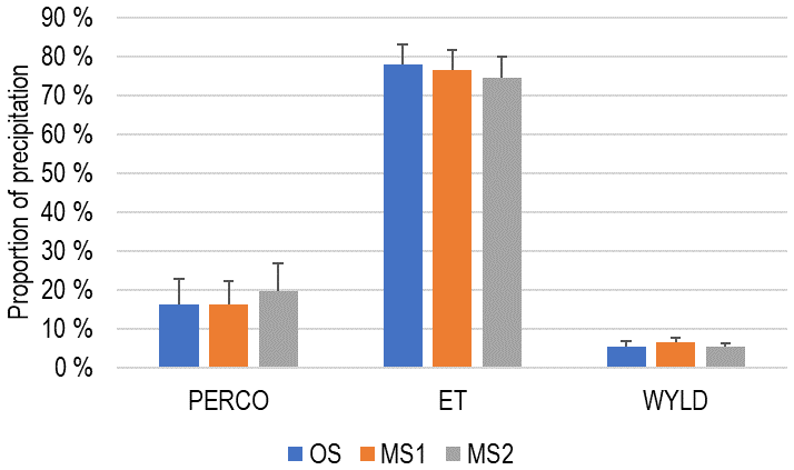
Figure 4Water balance of the White Volta catchment at Wayen over the period 2006–2012. PERCO: Percolation, WYLD: Water yield, ET: Actual Evapotranspiration.
3.2 Water balance of the Nakanbé catchment at Wayen station
The three modelling schemes led to similar results for the water balance of the Wayen catchment. Figure 4 shows the repartition of rainfall in the different components of the water balance. Over the period 2006–2012, more than 70 % of the rainfall is lost as actual evapotranspiration. The high evapotranspiration values observed in the Wayen catchment reflects the overall behaviour of the West African Sahel catchments. In such context, evapotranspiration is the most important term of the water balance (Derive, 2003).
In this study, we implemented several modelling schemes to capture the hydrological response of the Nakanbé catchment at Wayen station (21 178 km2). To this end, the SWAT model is applied with one-site, multi-sites with and without nested sub-catchments calibration schemes. The results showed that the multi-sites without nested sub-catchments scheme (MS2) performs well overall optimal (KGE = 0.75 and PBIAS = −1.70 %).
The SWAT agro-hydrological model is widely used due to its performance and wide range of applicability. However, this study findings suggest that multi-sites modelling under SWAT does not consider the upstream-downstream hydrological connection in nested sub-catchment during calibration. Therefore, integrating such hydrological connectivity in the model functioning is suggested to further improve the performance of the model, especially when applied to such contexts.
The data used are the property of national organizations in Burkina Faso: Direction Générale des Ressources en Eau (DGRE), Agence Nationale de la Météorologie (ANAM).
PYG: Conceptualization, Data curation, Methodology, Formal analysis, Software, Writing – original draft preparation, Writing-review and editing. RY and TF: Methodology, Formal analysis, Software, Writing-original draft preparation, Writing – review and editing. BEM, TB, YCH, EA and LOS: Writing – original draft preparation, Writing – review and editing. JEP, HK and HY: Conceptualization, Methodology, Formal analysis, Funding acquisition, Project administration, Writing original draft preparation, Writing-review and editing.
The contact author has declared that none of the authors has any competing interests.
Publisher's note: Copernicus Publications remains neutral with regard to jurisdictional claims made in the text, published maps, institutional affiliations, or any other geographical representation in this paper. While Copernicus Publications makes every effort to include appropriate place names, the final responsibility lies with the authors.
This article is part of the special issue “IAHS2022 – Hydrological sciences in the Anthropocene: Variability and change across space, time, extremes, and interfaces”. It is a result of the XIth Scientific Assembly of the International Association of Hydrological Sciences (IAHS 2022), Montpellier, France, 29 May–3 June 2022.
Participation in the conference was paid for by SYSTA (SIVAPALAN Young Scientists Travel Award). The research has been supported by the African Development Bank Group (Project no. P-Z1-IA0-013, grant no. 2100155032824).
This paper was edited by Christophe Cudennec and reviewed by Domiho Japhet Kodja and one anonymous referee.
Abbaspour, K. C.: SWAT calibration and uncertainty programs – A User Manual, eawag, 17–66, 2015.
Adjei, K. A., Ren, L., Appiah-Adjei, E. K., and Odai, S. N.: Application of satellite-derived rainfall for hydrological modelling in the data-scarce Black Volta trans-boundary basin, Hydrol. Res., 46, 777–791, https://doi.org/10.2166/nh.2014.111, 2015.
Akoko, G., Le, T. H., Gomi, T., and Kato, T.: A Review of SWAT Model Application in Africa, Water, 13, 1313, https://doi.org/10.3390/w13091313, 2021.
Akpoti, K., Antwi, E. O., and Kabo-bah, A. T.: Impacts of Rainfall Variability, Land Use and Land Cover Change on Stream Flow of the Black Volta Basin, West Africa, Hydrology, 3, 26, https://doi.org/10.3390/hydrology3030026, 2016.
Awotwi, A., Yeboah, F., and Kumi, M.: Assessing the impact of land cover changes on water balance components of White Volta Basin in West Africa, Water Environ. J., 29, 259–267, https://doi.org/10.1111/wej.12100, 2015.
Blöschl, G., Bierkens, M. F., Chambel, A., Cudennec, C., Destouni, G., Fiori, A., Kirchner, J. W., McDonnell, J. J., Savenije, H. H., Sivapalan, M., Stumpp, C., Toth, E., Volpi, E., Carr, G., Lupton, C., Salinas, J., Széles, B., Viglione, A., Aksoy, H., Allen, S. T., Amin, A., Andréassian, V., Arheimer, B., Aryal, S. K., Baker, V., Bardsley, E., Barendrecht, M. H., Bartosova, A., Batelaan, O., Berghuijs, W. R., Beven, K., Blume, T., Bogaard, T., Borges de Amorim, P., Böttcher, M. E., Boulet, G., Breinl, K., Brilly, M., Brocca, L., Buytaert, W., Castellarin, A., Castelletti, A., Chen, X., Chen, Y., Chen, Y., Chifflard, P., Claps, P., Clark, M. P., Collins, A. L., Croke, B., Dathe, A., David, P. C., de Barros, F. P. J., de Rooij, G., Di Baldassarre, G., Driscoll, J. M., Duethmann, D., Dwivedi, R., Eris, E., Farmer, W. H., Feiccabrino, J., Ferguson, G., Ferrari, E., Ferraris, S., Fersch, B., Finger, D., Foglia, L., Fowler, K., Gartsman, B., Gascoin, S., Gaume, E., Gelfan, A., Geris, J., Gharari, S., Gleeson, T., Glendell, M., Bevacqua, A. G., González-Dugo, M. P., Grimaldi, S., Gupta, A. B., Guse, B., Han, D., Hannah, D., Harpold, A., Haun, S., Heal, K., Helfricht, K., Herrnegger, M., Hipsey, M., Hlaváčiková, H., Hohmann, C., Holko, L., Hopkinson, C., Hrachowitz, M., Illangasekare, T. H., Inam, A., Innocente, C., Istanbulluoglu, E., Jarihani, B., Kalantari, Z., Kalvans, A., Khanal, S., Khatami, S., Kiesel, J., Kirkby, M., Knoben, W., Kochanek, K., Kohnová, S., Kolechkina, A., Krause, S., Kreamer, D., Kreibich, H., Kunstmann, H., Lange, H., Liberato, M. L. R., Lindquist, E., Link, T., Liu, J., Loucks, D. P., Luce, C., Mahé, G., Makarieva, O., Malard, J., Mashtayeva, S., Maskey, S., Mas-Pla, J., Mavrova-Guirguinova, M., Mazzoleni, M., Mernild, S., Misstear, B. D., Montanari, A., Müller-Thomy, H., Nabizadeh, A., Nardi, F., Neale, C., Nesterova, N., Nurtaev, B., Odongo, V. O., Panda, S., Pande, S., Pang, Z., Papacharalampous, G., Perrin, C., Pfister, L., Pimentel, R., Polo, M. J., Post, D., Sierra, C. P., Ramos, M.-H., Renner, M., Reynolds, J. E., Ridolfi, E., Rigon, R., Riva, M., Robertson, D. E., Rosso, R., Roy, T., Sá, J. H. M., Salvadori, G., Sandells, M., Schaefli, B., Schumann, A., Scolobig, A., Seibert, J., Servat, E., Shafiei, M., Sharma, A., Sidibe, M., Sidle, R. C., Skaugen, T., Smith, H., Spiessl, S. M., Stein, L., Steinsland, I., Strasser, U., Su, B., Szolgay, J., Tarboton, D., Tauro, F., Thirel, G., Tian, F., Tong, R., Tussupova, K., Tyralis, H., Uijlenhoet, R., Beek, R. V., Ent, R. J. V. , Ploeg, M. V. D., Loon, A. F. V., Meerveld, I. V., Oel. P. R. V., Vidal, J.-P., Freyberg, J. V., Vorogushyn, S., Wachniew, P., Wade, A. J., Ward, P., Westerberg, I. K., White, C., Wood, E. F., Woods, R., Xu, Z., Yilmaz, K. K., and Zhang, Y.: Twenty-three unsolved problems in hydrology (UPH) – a community perspective, Hydrol. Sci. J., 64, 1141–1158, https://doi.org/10.1080/02626667.2019.1620507, 2019.
Cao, W., Bowden, W. B., Davie, T., and Fenemor, A.: Multi-variable and multi-site calibration and validation of SWAT in a large mountainous catchment with high spatial variability, Hydrol. Process., 20, 1057–1073, https://doi.org/10.1002/hyp.5933, 2006.
Derive, G.: Estimation de l'évapotranspiration en région sahélienne: synthèse des connaissances et évaluation de modélisations (SISVAT, RITCHIE): application à la zone d'HAPEX-Sahel (Niger), PhD Thesis, Institut National Polytechnique De Grenoble, 189 pp., https://www.theses.fr/2003INPG0052 (last access: 14 October 2023), 2003.
Descroix, L., Guichard, F., Grippa, M., Lambert, L., Panthou, G., Mahé, G., Gal, L., Dardel, C., Quantin, G., Kergoat, L., Bouaïta, Y., Hiernaux, P., Vischel, T., Pellarin, T., Faty, B., Wilcox, C., Abdou, M. M., Mamadou, I., Vandervaere, J.-P., Diongue-Niang, A., Ndiaye, O., Sané, Y., Dacosta, H., Gosset, M., Cassé, C., Sultan, B., Barry, A., Amogu, O., Nka Nnomo, B., Barry, A., and Paturel J.-E.: Evolution of Surface Hydrology in the Sahelo-Sudanian Strip: An Updated Review, Water, 10, 748, https://doi.org/10.3390/w10060748, 2018.
Gbohoui, P.: Modélisation hydrologique de bassins emboîtes du Nakanbé au Burkina Faso dans un contexte de changement global (PhD Thesis), Université de Montpellier ; Institut International d'Ingénierie de l'Eau et de l'Environnement (2iE), 303 pp., https://hal-enpc.archives-ouvertes.fr/tel-03541807 (last access: 14 October 2023), 2021.
Gbohoui, Y. P., Paturel, J.-E., Fowe, T., Mounirou, L. A., Yonaba, R., Karambiri, H., and Yacouba, H.: Impacts of climate and environmental changes on water resources: A multi-scale study based on Nakanbé nested watersheds in West African Sahel, J. Hydrol.-Reg. Stud., 35, 100828, https://doi.org/10.1016/j.ejrh.2021.100828, 2021.
Migliaccio, K. W. and Chaubey, I.: Comment on Cao, W., Bowden, B. W., Davie, T., and Fenemor, A. 2006. “Multi-variable and multi-site calibration and validation of SWAT in a large mountainous catchment with high spatial variability”, Hydrol. Process., 20, 1057–1073, Hydrol. Process., 21, 3226–3228, https://doi.org/10.1002/hyp.6491, 2007.
Neitsch, S. L., Arnold, J. G., Kiniry, J. R., and Williams, J. R.: Soil and water assessment tool theoretical documentation version 2009, Texas Water Resources Institute, 2011.
Paturel, J. E., Mahé, G., Diello, P., Barbier, B., Dezetter, A., Dieulin, C., Karambiri, H., Yacouba, H., and Maiga, A.: Using land cover changes and demographic data to improve hydrological modeling in the Sahel, Hydrol. Process., 31, 811–824, https://doi.org/10.1002/hyp.11057, 2016.
Poméon, T., Diekkrüger, B., Springer, A., Kusche, J., and Eicker, A.: Multi-Objective Validation of SWAT for Sparsely-Gauged West African River Basins – A Remote Sensing Approach, Water, 10, 451, https://doi.org/10.3390/w10040451, 2018.
Schuol, J., Abbaspour, K. C., Srinivasan, R., and Yang, H.: Estimation of freshwater availability in the West African sub-continent using the SWAT hydrologic model, J. Hydrol., 352, 30–49, 2008.
Sood, A., Muthuwatta, L., and McCartney, M.: A SWAT evaluation of the effect of climate change on the hydrology of the Volta River basin, Water Int. 38, 297–311, https://doi.org/10.1080/02508060.2013.792404, 2013.
Tan, M. L., Gassman, P. W., Yang, X., and Haywood, J.: A review of SWAT applications, performance and future needs for simulation of hydro-climatic extremes, Adv. Water Resour., 143, 103662, https://doi.org/10.1016/j.advwatres.2020.103662, 2020.
Thiemig, V., Rojas, R., Zambrano-Bigiarini, M., and De Roo, A.: Hydrological evaluation of satellite-based rainfall estimates over the Volta and Baro-Akobo Basin, J. Hydrol., 499, 324–338, https://doi.org/10.1016/j.jhydrol.2013.07.012, 2013.
Yonaba, R., Biaou, A. C., Koïta, M., Tazen, F., Mounirou, L. A., Zouré, C. O., Queloz, P., Karambiri, H., and Yacouba, H.: A dynamic land use/land cover input helps in picturing the Sahelian paradox: Assessing variability and attribution of changes in surface runoff in a Sahelian watershed, Sci. Total Environ., 757, 143792, https://doi.org/10.1016/j.scitotenv.2020.143792, 2021a.
Yonaba, R., Koïta, M., Mounirou, L. A., Tazen, F., Queloz, P., Biaou, A. C., Niang, D., Zouré, C., Karambiri, H., and Yacouba, H.: Spatial and transient modelling of land use/land cover (LULC) dynamics in a Sahelian landscape under semi-arid climate in northern Burkina Faso, Land Use Policy, 103, 105305, https://doi.org/10.1016/j.landusepol.2021.105305, 2021b.
Zanin, P. R., Bonuma, N. B., and Corseuil, C. W.: Hydrosedimentological modeling with SWAT using multi-site calibration in nested basins with reservoirs, RBRH, 23, 26, https://doi.org/10.1590/2318-0331.231820170153, 2018.
Zhang, Y., Xia, J., Shao, Q., and Zhai, X.: Water quantity and quality simulation by improved SWAT in highly regulated Huai River Basin of China, Stoch. Environ. Res. Risk A., 27, 11–27, https://doi.org/10.1007/s00477-011-0546-9, 2013.