the Creative Commons Attribution 4.0 License.
the Creative Commons Attribution 4.0 License.
 | 19 Apr 2024
Multidisciplinary approach to understand the salinization of fractured crystalline aquifers in semi-arid region
Marjorie Beate Kreis
Jean-Denis Taupin
Nicolas Patris
Patrick Lachassagne
Virginie Vergnaud-Ayraud
Julien Daniel Pierre Burte
Christian Leduc
Eduardo Sávio Passos Rodrigues Martins
In semi-arid areas, groundwater (GW) represents the most reliable resource for water supply. In the semi-arid region of Ceará (Northeastern Brazil), GW of the crystalline fractured aquifers has a salinity higher than expected in this type of environment. This study implemented a multidisciplinary approach based on hydrodynamic (piezometric) and hydrogeochemical (18O, 2H, 3H, 14C, CFC, SF6, Electrical Conductivity, major ions) data to understand the salinization processes. Results demonstrate that GW is generally recent and recharged by meteoric waters mainly through indirect infiltration from evaporated surface water. The study suggests that GW, originally bicarbonated, becomes progressively enriched in chloride due to the dissolution and leaching of salts, during the wet season, which come from meteoric inputs and have precipitated in the unsaturated zone and pond sediments during dryer periods.
- Article
(1604 KB) - Full-text XML
- BibTeX
- EndNote


SDG6; Field observation
In crystalline aquifers, groundwater (GW) resources are generally scarce and may be subject to salinization, notably in semi-arid areas (Rabemanana et al., 2005; Jalali, 2007; Sreedevi et al., 2021). In semi-arid Northeastern Brazil (NEB), the processes at the origin of the high and heterogeneous GW salinity observed in the crystalline basement are still controversial. In Ceará (a state in semi-arid NEB), almost 75 % of the area consists of Precambrian basement rock (Santiago et al., 2001; Osorio, 2018). However, the hydrogeological functioning of the crystalline aquifers remains unclear despite the importance of this resource to cope with the lack of water in rural areas, especially during prolonged drought. Given the complexity of fractured medias, this study used a multidisciplinary approach to understand the hydrogeological functioning and hydrochemical processes that lead to GW salinization through the implementation of a monitoring network of the electrical conductivity (EC) and the piezometric levels, a multi-tracer sampling (18O, 2H, 3H, 14C, CFC, SF6) and the analysis of major ions.
2.1 Geographic and climatic context
The study area is included in the Banabuiú watershed (19 647 km2), in the center of the Ceará at approximately 180 km of the oceanic coast. Investigations were carried out in four sub-basins of the Banabuiú watershed: Forquilha (214 km2), Pirabibú (127 km2), Vista Alegre (550 km2) and Ibicuitinga (286 km2), located between the latitudes 4°54′38′′ S and 5°29′08′′ S, and the longitudes 38°27′38′′ W and 39°39′55′′ W (Fig. 1). These are rural areas of low human density, inserted in the Caatinga biome, whose socioeconomic development is mainly based on livestock and agriculture (MME, 1998).
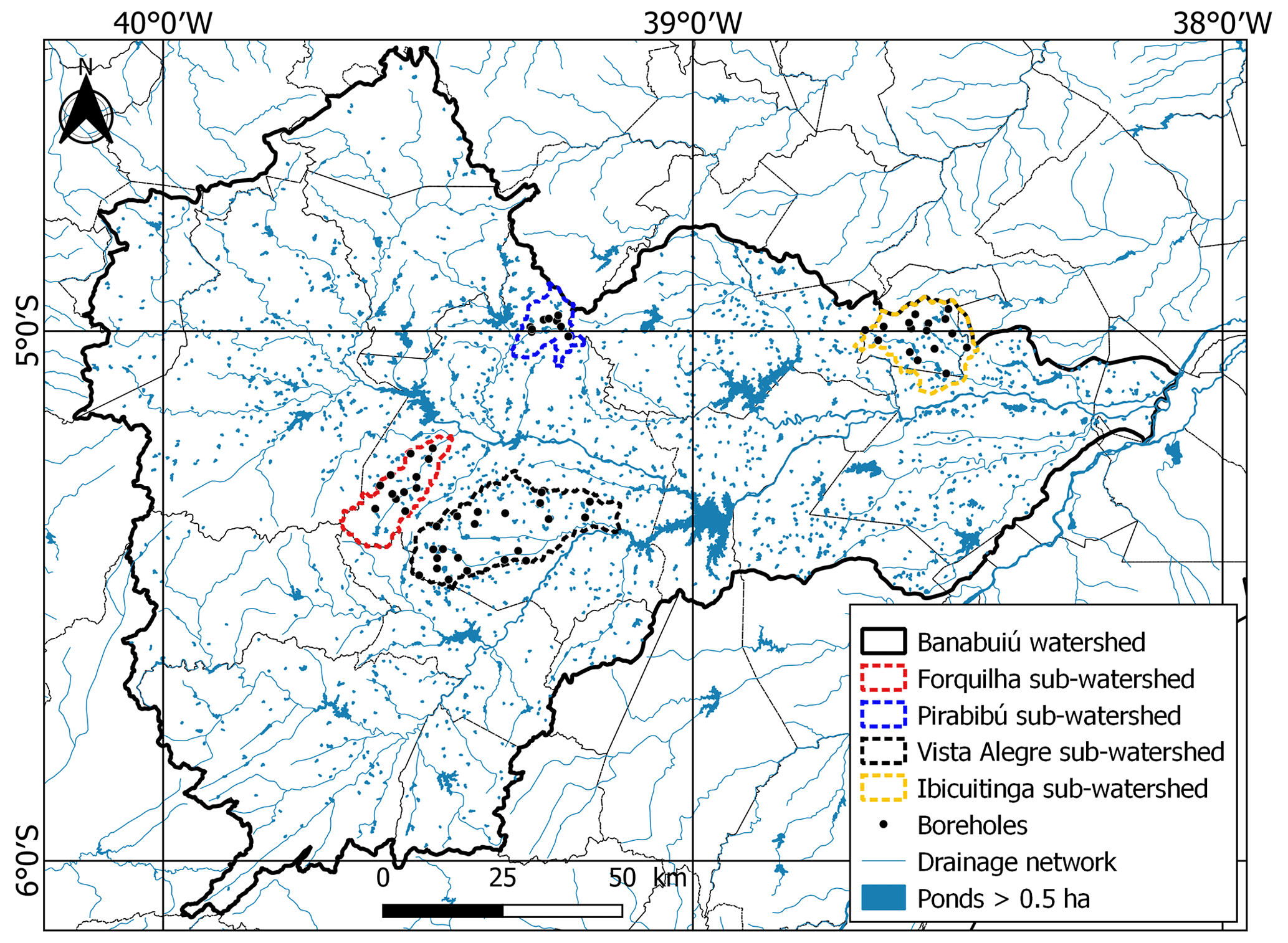
Figure 1Map of the study area.
The semi-arid climate of the study zone is characterized by water deficiency due to low precipitation levels (<800 mm yr−1), high evapotranspiration (PET) rates (>1000 mm yr−1), irregular rainfall distribution and recurrent drought periods (Burte, 2008; Martins and Júnior, 2017; Pontes Filho et al., 2020). The wet season, which extends from December to July, concentrates around 75 % of the precipitation over 4 months of the year (from February to May) in the study area. Moreover, these four months of rain are characterized by intense rainfall events (Costa and Herrera, 2016). The annual mean temperature is 27.2 °C, with monthly mean temperatures ranging between 25.7 and 28.5 °C. The monthly mean relative humidity varies from 41.6 % to 85.9 %, with an annual mean of 61.0 % (data from hydrometric INMET Station no. 82586, 1981–2010 period).
2.2 Hydrological context
In the crystalline zones of the study area, surface runoff is of Hortonian type due to the low thickness (<1 m) and the low permeability of soils (Burte, 2008). In combination with the meteorological characteristics, all Ceara rivers are naturally intermittent (Santiago et al., 2001; Burte, 2008; Ribeiro Neto et al., 2022). The Banabuiú watershed is characterized by a large number of small and big dams, with more than 12 820 reservoirs mapped out by the FUNCEME (with an area greater than 0.5 ha). These reservoirs are subject to high evaporation losses and, consequently, to salinization and eutrophication problems (Santiago et al., 2001).
2.3 Geological and hydrogeological context
The Banabuiú watershed is characterized by the outcropping of the crystalline basement over 96.5 % of its surface. These rocks are represented by various types of gneisses and migmatites of Precambrian age, associated with plutonic and metaplutonic rocks of predominantly granitic composition (INESP, 2009). The remaining 3.5 % of the area are composed of Tertiary and Quaternary sediments (probably only Pleistocene according to Cavalcanti and Cavalcante, 2014) and colluvial-eluvial Quaternary covers. All of these Cenozoic sediments are interpreted as fluvial-lacustrine deposits (Da Silva et al., 2003).
The hydrogeological knowledge of the Ceará State is still very limited (Funceme, 2007). The presence of aquifers in the crystalline basement is related to the degree of alteration and fracturing of the rock, considering their very low primary porosity and permeability (Wyns, 2004; Lachassagne et al., 2021). In the study region, the median depth of water wells is 60 m and the level of the water table is generally around 10 m below the ground surface (Da Silva et al., 2007). Wells present low flow rates (1 to 3 m3 h−1). GW of the crystalline aquifers of Ceará may present very high EC values for this type of environment. No regional flow is observed according to Santiago et al. (2000), which means that the natural outlet of the crystalline aquifers is locally formed by the river or the alluvium (or a spring), at the scale of small sub-basins, unless evapotranspiration creates endorheic conditions.
Investigations were developed on two main axes. On one side, the study of the subterranean hydrodynamics thanks to the implementation of a piezometric monitoring network and the realization of a multi-tracers sampling (18O, 2H, 3H, 14C, CFC, SF6). On the other side, the study of the hydrochemical composition and evolution of GW thanks to the establishment of an EC monitoring network and the analysis of major ions. Studied borewells are distributed in the crystalline basement of the four sub-watersheds. All sampled borewells were pumped before sampling until stabilization of pH, temperature and EC parameters. Field parameters were measured in situ using an Aquaprobe® AP-700 multiparameter instrument.
3.1 Piezometric monitoring network
Monthly and hourly piezometric data were collected from March 2018 to December 2019 over a network of 56 boreholes, and from November 2016 to December 2019 in four of these boreholes, respectively.
3.2 Stable isotopes (18O, 2H) analyses
The water stable isotopes (δ18O, δ2H) were measured on GW from 75 borewells (137 samples) sampled between August 2016 and August 2019. Analyses were performed in the water stable isotope analysis Laboratory (LAMA) of Hydrosciences Montpellier (France). Results are expressed in δ ‰ vs V-SMOW (Vienna Standard Mean Ocean Water) as defined by Craig (1961). Analytical errors are ±0.08 ‰ and ±0.8 ‰ for δ18O and δ2H, respectively.
3.3 Multi-tracer dating (3H, 14C, CFC, SF6) analyses
GW samples were taken from 3 borewells in November 2009 and from 7 borewells in February 2018 for 14C and 3H analyses, and from 10 borewells in June 2019 for CFC and SF6 analyses. 14C and 3H analyses were carried out at the laboratory of Avignon University (France) and are respectively expressed as pMC (percent modern carbon) and TU (tritium unit). Analytical errors are about 0.5 pMC and 0.3 TU, respectively. CFC and SF6 analyses were performed at the Plateforme Condate Eau of Rennes University (France) and are within a precision of 3 % for CFC and 5 % for SF6.
3.4 Hydrochemical analyses (EC, major ions)
An EC monitoring was carried out in conjunction with the monthly piezometric monitoring to evaluate the salinity dynamics of GW. Major ions sampling campaigns were conducted in December 2017 (dry season) and June 2018 (wet season) in 27 and 38 borewells, respectively. Major ions analyses were performed in the GECOQ laboratory of the CAGECE in Fortaleza (Brazil), in accordance with methodologies recommended by APHA (2012).
4.1 Hydrodynamic characterization
4.1.1 Piezometric monitoring
Piezometric monitoring evidenced that GW levels are relatively shallow, between 0.4 and 21.4 m deep. A contrasted temporal variation of piezometric levels was observed, with annual variations varying from 0.2 to 5.9 m depending on the boreholes. Seasonal recharge occurs during the rainy season, between February and May. Hourly piezometric monitoring showed a strong reactivity of GW levels (<24 h) to significant rainy events (>50–60 mm), but a decrease of the level is almost never observed following the event. Instead, the levels gradually increase throughout the rainy season. Analysis of the variations in GW levels suggests that the seasonal recharge depends on the distribution and amounts of daily rainfall and is favoured by the storage of surface runoff in ponds.
4.1.2 Stable isotopes monitoring (18O, 2H)
δ18O and δ2H values of GW samples showed a strong spatio-temporal variability and ranged between −4.04 ‰ and +1.75 ‰ and between −23.3 ‰ and +8.0 ‰, respectively, with median values of for δ18O and for δ2H. GW presents low values of deuterium excess, with a median value of . The relationship between δ18O and δ2H of GW is expressed by Eq. (1):
The slope of 5.09 of Eq. (1) is lower than the slope of the local meteoric water line (LMWL) defined in Kreis et al. (2020) and the global meteoric water line (GMWL), and clearly indicates that meteoric waters undergo significant evaporation before their infiltration (Chatton et al., 2016). Moreover, Eq. (1) is very similar to the linear regressions obtained by Matsui (1978) and by Stolf et al. (1977), cited in Matsui (1978) for surface waters in the NEB, which are respectively of δ2H O – 0.5 (r2=0.97) and δ2H O – 1.3. Therefore, the strong similarity between the linear regressions of GW and surface water highlights that part of GW recharge occurs through a mixing process involving surface water marked by evaporation. This hypothesis is consistent with the numerous dams, lagoons and temporary drainage networks existing in the study area, and is supported by the GW level survey.
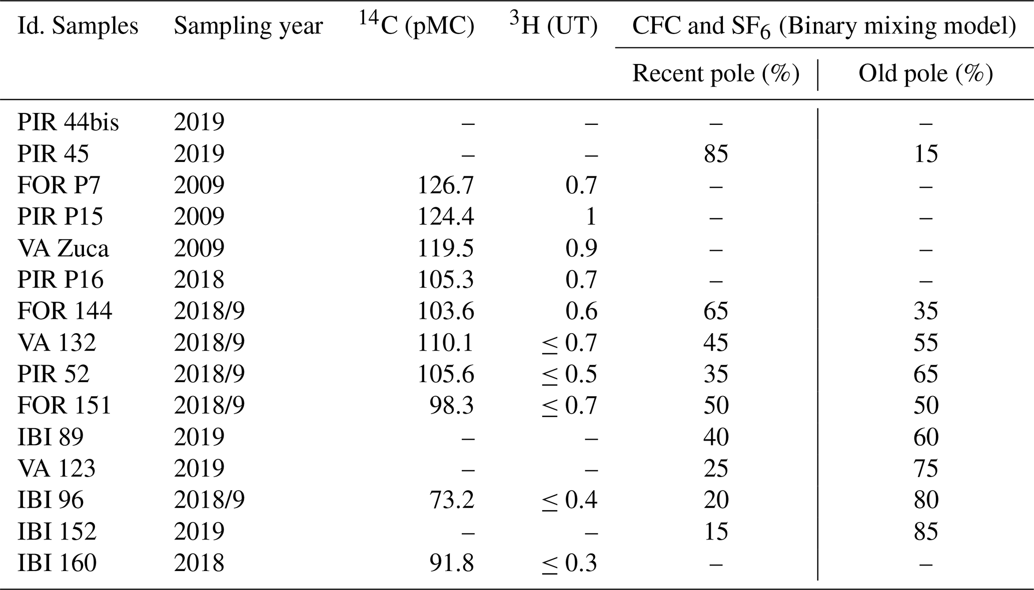
Table 1Results of the multi-tracer dating. FOR = Forquilha, PIR = Pirabibú, VA = Vista Alegre, IBI = Ibicuitinga.
4.1.3 Multi-tracer dating (14C, 3H, CFC, SF6)
The assessment of GW residence time through a multi-tracer approach showed that the apparent age of the GW varies from a few decades to hundreds of years. It also underlined the large contribution of post-1950s water in the recharge processes with 14C values generally higher than 100 pMC and measurable 3H values, but highlighted the complexity of flow path organization in the fractured crystalline system. Indeed, CFC and SF6 analyses, best interpreted by a binary mixing model (BMM), suggested the influence of water mixing between a recent pole (15 % to 85 % of the contributions) corresponding to a present-day recharge (fast vertical flows) and an older pole of longer transit time (interpreted as slow horizontal transfers). The BMM is based on the mixing of two piston flow water bodies. Contrary to the classical BMM which allows mixing between young (current CFC values) and old (CFC free) reservoirs, Condate Eau Plateform (Rennes University) tests the date allowing mixing with more or less young and more or less old waters. The result given is the best combination of mixing result (age and proportion) obtained for each tracers. The uncertainty in the model results depends on the adequacy between the results given by the different tracers and does not exceed 20 % and 10 years. Results of the multi-tracer dating are synthesized in Table 1.
4.2 Hydrogeochemical characterization
4.2.1 Electrical conductivity (EC) monitoring
The EC monitoring highlighted a strong spatial heterogeneity of the crystalline media, with EC values ranging between 886 and 19 310 µS cm−1 (median value of 2850 µS cm−1) and no salinity gradient. During the wet season, most boreholes show a temporary and fast increase of EC which suggests a leaching of salts stored in sediments, soil or in the unsaturated zone (USZ) during drier periods.
4.2.2 Major ions sampling
More than 75 % of the samples presented a mixed chloride or sodium chloride facies. However, the less salty waters (EC <1600 µS cm−1) presented a bicarbonated facies (<10 % of the samples), whereas they tended towards a chloride facies with the increase in salinity. The chemical sampling before and after the rainy season showed a displacement of the points from the sodium pole towards the mixed pole, which suggests, in association with the observed increase in EC, a phenomenon of dissolution of calcium and/or magnesium salts (as calcite or dolomite). The strong correlation between EC and chloride (r2=0.9) or cations () and the absence of correlation between EC and bicarbonate, sulphate or nitrate (r2<0.1) indicates that the origin of high salinity is not related to the water/rock interaction or the anthropic pollution.
4.3 Origin of groundwater salinization
Among the processes that lead to salinization of GW, marine intrusions and the presence of marine evaporitic rocks are ruled out considering the distance from the study zone to the oceanic coast and the absence of primary evaporitic terms in the Precambrian crystalline basement of the region. Moreover, the hypothesis of a past marine transgression is incompatible with the measured residence time of water. Mineral hydrolysis of crystalline rocks may explain part of the water mineralization, but not the predominance of chloride ion or the high salinization of GW. Considering that the chlorides and the GW salinity are not related to anthropic pollution, it results that the chloride source is external to the aquifer and derives from meteoric inputs (in the form of wet or dry depositions). Furthermore, the chemical study suggests that the GW, originally bicarbonated, becomes progressively enriched in chloride due to the dissolution and leaching of salts that were precipitated in the USZ and pond sediments during the dry season owing to the strong evapotranspiration rates, as observed in Madagascar (Rabemanana et al., 2005) or India (Sreedevi et al., 2021), for example. The precipitation of salts on the surface is favoured by alternating dry and wet periods (Sreedevi et al., 2021). The hypothesis of leaching of salts is supported by the observation of evaporite minerals (calcite, dolomite, gypsum, halite and probably bischofite) on the banks and sediments of the dams in the study area (Laraque, 1991; Araújo, 2017) and the presence of evaporated water in the aquifers.
This multidisciplinary study used hydrogeochemical and isotopic approaches, associated with piezometric data, to understand the hydrogeological functioning and the origin of the salinity of a complex crystalline system. Generally, the contrasted temporal and spatial variations of piezometric levels or hydrochemical composition of GW highlighted the strong heterogeneity and compartmentalization of the crystalline aquifers, as well as the influence of local processes. The combination of results allows to identify that GW recharge occurs through both direct and indirect infiltration, with a significant proportion of evaporated surface water. The GW residence time is relatively short (significant supply of post-1950s water) and the flow paths organization is mainly composed of rapid vertical flows. In these aquifers, the salinity is interpreted as originating from rainfall. The evapo(transpi)ration of small rainfall events or surface waters during the dry periods favors the concentration of atmospheric salts on the surface. This study suggests that the GW becomes progressively salinized due to the dissolution and leaching of evapoconcentrated salts precipitated in the unsaturated zone and pond sediments, given the high evapotranspiration in the partially endorheic context.
The research data presented in this study can be found in Kreis (2021), accessible at: https://www.theses.fr/2021MONTG031.
MBK carried out the investigations and interpretations of this study under the scientific supervision of JDT, CL, PL and ESPRM. JDPB carried out the 2009 sampling campaign for the measurement of 14C and 3H. NP and VVA performed respectively the stable isotope and the CFC/SF6 analyses. MBK prepared the manuscript with contributions from all co-authors.
The contact author has declared that none of the authors has any competing interests.
Publisher’s note: Copernicus Publications remains neutral with regard to jurisdictional claims in published maps and institutional affiliations.
This article is part of the special issue ”IAHS2022 – Hydrological sciences in the Anthropocene: Variability and change across space, time, extremes, and interfaces”. It is a result of the XIth Scientific Assembly of the International Association of Hydrological Sciences (IAHS 2022), Montpellier, France, 29 May–3 June 2022.
This work is part of the multidisciplinary French-Brazilian cooperation between IRD and FUNCEME. The authors would thank the LAMA laboratory and the FUNCEME for all the financial and technical support.
This research has been supported by internal funding from Research Institutes of authors (LAMA laboratory from Hydrosciences Montpellier and FUNCEME).
This paper was edited by Christophe Cudennec and reviewed by three anonymous referees.
American Public Health Association (APHA): Standard methods for the examination of water and wastewater, 22th edition, edited by: Rice, E. W., Baird, R. B., Eaton, A. D., and Clesceri, L. S., American Public Health Association (APHA), American Water Works Association (AWWA) and Water Environment Federation (WEF), Wahington, DC, 1100 pp., 2012.
Araújo, A.: Mecanismos dominantes na salinização de água em rochas anisotrópicas com base em razões iônicas e número fuzzy, em área do sertão central no Ceará, PhD Thesis, Federal university of Ceará, 188 pp., http://repositorio.ufc.br/handle/riufc/53426, 2017.
Burte, J.: Os pequenos aquiferos aluviais nas areas cristalinas semi-aridas: Funcionamento e estrategias de gestao, Estudo de caso no Nordeste brasileiro, PhD Thesis, University of Montpellier, https://agritrop.cirad.fr/547686/ (last access: 28 September 2023), 2008.
Cavalcanti, J. A. D. and Cavalcante, J. C.: Evoluição geológica, in: Geodiversidade do estado do Ceará, CPRM, 19–34, https://rigeo.sgb.gov.br/handle/doc/16726, 2014.
Chatton E., Aquilina L., Petelet-Giraud E., Cary, L., Bertrand, G., Labasque, T., Hirata, R., Martins, V., Montenegro, S., Vergnaud, V., Aurouet, A., and Kloppmann, W.: Glacial recharge, salinization and anthropogenic contamination in the coastal aquifers of Recife (Brazil), Sci. Total Environ., 569, 1114–1125, https://doi.org/10.1016/j.scitotenv.2016.06.180, 2016.
Costa, C. S. B. and Herrera, O. B.: Halophytic life in Brazilian Salt Flats: Biodiversity, Uses and Threats, in: Sabkha Ecosystems, edited by: Khan, M. A., Boër, B., Özturk, M., Clüsener-Godt, M., Gul, B., and Breckle, S. W., Volume V, The Americas (Vol. 48), Springer, https://doi.org/10.1007/978-3-319-27093-7_2, 2016.
Craig, H.: Standard for reporting concentrations of deuterium and oxygen-18 in natural waters, Science, 133, 1833–1834, 1961.
Da Silva, A. J. P., Lopes, R. C. L., Vasconcelos, A. M., and Bahia, R. B. C.: Capítulo II – Bacias sedimentares paleozoicas e meso-cenozoicas interiores, in: Geologia, Tectônica e Recursos Minerais do Brasil, CPRM: Brasília, ISBN 85-230-0790-3, 55–85, 2003.
Da Silva, F. J. A., de Araújo, A. L., and de Souza, R. O.: Águas subterrâneas no Ceará – poços instalados e salinidade, Revista Tecnologia, 28, 136–159, 2007.
Funceme: Mapeamento e Avaliação do Potencial Hídrico Subterrâneo dos Aluviões em Zonas SemiÁridas Utilizando Técnicas de Sensoriamento Remoto e SIG, Fortaleza: Governo do Estado do Ceará, http://www.funceme.br/wp-content/uploads/2019/02/Aluviao.pdf (last access: 30 April 2022), 2007.
INESP: Caderno regional da sub-bacia do Banabuiú, Vol.2, Fortaleza, Instituto Nacional de Ensino e Pesquisa (INESP), ISBN 978-85-87764-99-7, 2009.
Jalali, M.: Salinization of groundwater in arid and semi-arid zones: an example from Tajarak, western Iran, Environ. Geol., 52, 1133–1149, https://doi.org/10.1007/s00254-006-0551-3, 2007.
Kreis, M.: Origine et dynamique de salinité des aquifères fracturés cristallins de la région semi-aride du Ceará, Brésil, PhD Thesis, University of Montpellier, Federal University of Ceará, NNT: 2021MONTG03, https://www.theses.fr/2021MONTG031 (last access: 23 May 2022), 2021.
Kreis, M., Taupin, J. D., Patris, N., and Martins, E. S. P. R.: Isotopic characterisation and dating of groundwater recharge mechanisms in crystalline fractured aquifers: example of the semi-arid Banabuiú watershed (Brazil), Isot. Environ. Healt. S., 56, 418–430, https://doi.org/10.1080/10256016.2020.1797275, 2020.
Lachassagne, P., Dewandel, B., and Wyns, R.: Review: Hydrogeology of weathered crystalline/hard-rock aquifers–guidelines for the operational survey and management of their groundwater resources, Hydrogeol. J., 29, 2561–2594, https://doi.org/10.1007/s10040-021-02339-7, 2021.
Laraque, A.: Comportements hydrochimiques des” açudes” du Nordeste brésilien semi-aride: évolutions et prévisions pour un usage en irrigation, PhD Thesis, University of Montpellier 2, 446 pp., https://www.theses.fr/1991MON20003 (last access: 23 May 2022), 1991.
Martins, E. S. P. R. and Júnior, F. D. C. V.: O clima da Região Nordeste entre 2009 e 2017: Monitoramento e previsão, Parcerias Estratégicas, 22, 63–79, 2017.
Matsui, E.: Origem e dinâmica de salinização da água do nordeste brasileiro – Bacia do rio Pajeú/PE, PhD Thesis, USP: Piracicaba/SP, 1978.
Ministério de Minas e Energia (MME): Programa de recenseamento de fontes de abastecimento por água subterrânea no Estado do Ceará. Diagnóstico do município de Quixeramobim, CPRM: Fortaleza, 15 pp., https://rigeo.sgb.gov.br/handle/doc/16611, 1998.
Osorio, D. B.: Hidrogeologia do semiárido Cearense, M.S. Thesis, University of São Paulo, https://doi.org/10.11606/D.44.2019.tde-30052019-131248, 2018.
Pontes Filho, J. D., Souza Filho, F. D. A., Martins, E. S. P. R., and Studart, T. M. D. C.: CopulaBased Multivariate Frequency Analysis of the 2012–2018 Drought in Northeast Brazil, Water, 12, 834, https://doi.org/10.3390/w12030834, 2020.
Rabemanana, V., Violette, S., De Marsily, G., Robain, H., Deffontaines, B., Andrieux, P., Bensimon, M., and Parriaux, A: Origin of the high variability of water mineral content in the bedrock aquifers of Southern Madagascar, J. Hydrol., 310, 143–156, https://doi.org/10.1016/j.jhydrol.2004.11.025, 2005.
Ribeiro Neto, G. G., Melsen, L. A., Martins, E. S. P. R., Walker, D. W., and van Oel, P. R.: Drought Cycle Analysis to evaluate the influence of a Dense Network of small reservoirs on drought evolution, Water Resour. Res., 58, https://doi.org/10.1029/2021WR030799, 2022.
Santiago, M. F., Frischkorn, H., Neto, P. S., and Filho, M. J.: The recharge mechanisms in an alluvial aquifer zone in northeast Brazil, Groundwater, 39, 18–23, https://doi.org/10.1111/j.1745-6584.2001.tb00347.x, 2001.
Santiago, M. M. F., Frischkorn, H., and Mendes Filho, J.: Mecanismos de salinização em águas do Ceará, Rio Grande do Norte e Piauí. Águas Subterrâneas, Anais do XI Congresso Brasileiro de Águas Subterrâneas, 16 pp., https://aguassubterraneas.abas.org/asubterraneas/article/view/23481 (last access: 28 September 2023), 2000.
Sreedevi, P. D., Sreekanth, P. D., and Reddy, D. V.: Influence of hydrological and hydrogeological factors on inland groundwater salinity in a hard rock aquifer, south India, J. Earth Syst. Sci., 130, 215, https://doi.org/10.1007/s12040-021-01715-x, 2021.
Stolf, R., Leal, J. M., Fritz, P., and Salati, E.: Water budget of a dam in the semi-arid Northeast of Brazil based on oxygen-18 and chlorine contents, in: Isotopes in lake studies, Proceedings Series, 29 August–2 September 1977, Vienna International Atomic Energy Agency No. ST1/PUB/511, 57–66, Vienna, 1979.
Wyns, R., Baltassat, J. M., Lachassagne, P., Legtchenko, A., Vairon, J., and Mathieu, F.: Application of Proton Magnetic Resonance Soundings to groundwater reserve mapping in weathered basement rocks (Brittany, France), B. Soc. Geol. Fr., 175, 21–34, https://doi.org/10.2113/175.1.21, 2004.