the Creative Commons Attribution 4.0 License.
the Creative Commons Attribution 4.0 License.
Quantifying snow sublimation by Eddy covariance measurements on the High Atlas Mountain of Marrakech at Tazaghart plateau, Morocco
Ouiaam Lahnik
Simon Gascoin
Adnane Chakir
Vincent Simonneaux
The High Atlas Mountains are a valuable source of water supply to lowland areas, in the Tensift watershed around Marrakech and play an important role in the hydrologic processes and water balance. The solid part of precipitation in these areas is important and forms a seasonal snowpack where water is stored during winter. Therefore, an accurate assessment of sublimation is essential in the overall hydrological cycle. In this context, we estimated the sublimation on the Tazaghart plateau located in the High Atlas of Marrakech, using a dataset measured with the Eddy covariance system (EC) for a period from September 2020 to January 2021. The temporal variation in measured sublimation illustrated a diurnal cycle with a peak in the early afternoon and the highest relative snow sublimation fluxes occurred with subzero temperatures and low atmospheric humidity. The average daily sublimation rate measured was 0.41 mm d−1. Measured sublimation accounted for 42 % and 40 % of snow ablation, based on the energy and water balance respectively. The estimated percentages are comparable, which supports reliable measurements and provides important validation of the Eddy covariance method. This study shows how the Eddy covariance method can be useful for direct measurements of winter water loss due to the sublimation of snowpacks in rather inaccessible regions where measurements are relatively rare.
- Article
(2571 KB) - Full-text XML
- BibTeX
- EndNote
UPH 16; SDG 06; Snow sublimation; Eddy covariance; Tazaghart plateau; High Atlas
Mountain areas are often a valuable source of water supply in semi-arid watersheds and play an important role in the hydrologic processes and water balance. Precipitation in high-altitude areas is important and forms a seasonal snowpack where water is stored during winter (Hanich et al., 2022). The High Atlas Mountains in Central Morocco, where a large part of precipitation falls as snow, are the country's most vital water supply and contribute greatly to socioeconomic development. Despite the importance of snow in the High Atlas Mountains, the processes controlling snowpack evolution in this region have not been thoroughly researched. According to a prior study, high altitude circumstances in the High Atlas, i.e., low air pressure, high wind speed, and dry air, should favour sublimation, where sublimation is defined as a loss of water resources from the snowpack to the atmosphere. However, sublimation rates in the High Atlas are unknown. Therefore, a better knowledge of snow sublimation's contribution to the annual water balance of mountain watersheds is required.
Many studies have been conducted in arid and semi-arid region to investigate the spatial and temporal variability of snow sublimation (Liston and Elder, 2006; Ault et al., 2006; Bosilovich, 2006; Dietz et al., 2015), but few have been based on point measurements in mountainous terrain. Previous studies in the High Atlas region have estimated snowmelt and sublimation rates using modelling approaches (Boudhar et al., 2016; Baba et al., 2018). Therefore, an accurate assessment of sublimation is essential in the overall hydrological cycle. In this context, an eddy-covariance flux station was installed on the Tazaghart plateau, a wide flat area located at 3850 m a.s.l. in the High Atlas Mountain of Morocco, allowing continuous acquisitions between September 2020 and January 2021, with a timestep of 30 min, in order to estimate evapotranspiration and sublimation processes.
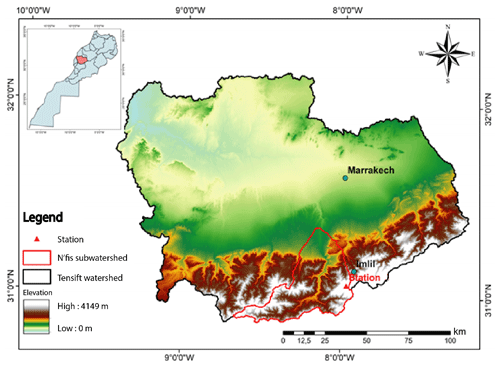
This research focuses on the Tazaghart plateau, which is located in the N'fis watershed of the High Atlas of Marrakech, as depicted in Fig. 1. The plateau covers roughly 1.3 km3 and has a mean altitude of 3850 m. It is located at 31°3′40.3′′ N and of 7°58′1.5′′ W. The plateau has a typical continental climate, with cold, dry weather and high radiation. The Tazaghart plateau, with its peculiar climatic conditions and topography, is an ideal place for conducting Eddy covariance measurements, which are noted for their homogeneity at the plateau level.
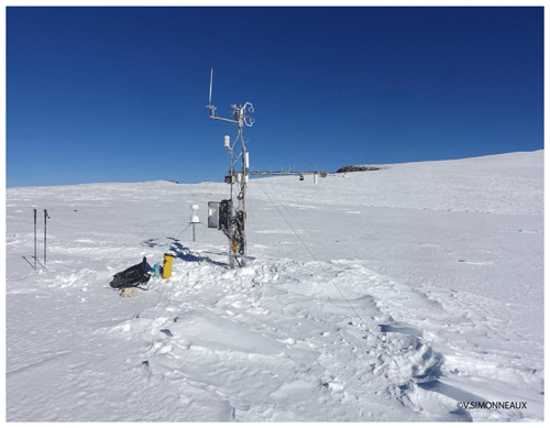
Meteorological data were collected between September 2020 and January 2021 using an automatic weather station (AWS) located on the Tazaghart plateau (Fig. 2). The eddy covariance method is a direct measurement of the turbulent flux density of a scalar (temperature, momentum, water vapor concentration) across the wind streamlines (Reba et al., 2012). The method analyzes high-frequency datasets of wind and scalar values and produces fluxes of its properties.
3.1 Energy balance
In our study, we aimed to determine the balance between all the energy processes that affect the snowpack during a specific time interval. To achieve this, we utilized the following equation:
that incorporates various energy fluxes, including net radiation flux (Rn), soil heat flux (G), sensible heat flux (H), latent heat flux bound to sublimation (LE), and energy available for melting the snow (F). We focused on a time interval from 09:00 to 17:00 UTC when the net energy is positive.
3.2 Sublimation measurements
The snow sublimation flux is calculated according to the following equation:
Where Lvi = 2.838106 J kg−1 at 0 °C is the latent heat of sublimation of the ice and LE is the latent heat flux.
3.3 Sublimation rate
The sublimation and melt rates are calculated according to the relationship:
Neglecting the transport of snow by the wind and the refreezing of liquid water in the snowpack, the total ablation of snow is estimated either from the water balance:
or from the energy balance:
The remaining snow residue (R) calculated from following equation:
Where P is precipitation, S is sublimation, and F is melting.
The residual is calculated by converting the snow height into its water equivalent (SWE Snow water Equivalent), according to the relation:
Where the average snow density is estimated to be 300 kg m−3 (for fresh snow), based on Boudhar et al. (2009) measurements. This value is for fresh snow as the snow does not stay long and melts.
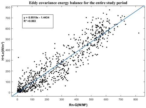
The verification of the closure of the energy balance is crucial to ensure the accuracy of turbulent flow measurements. Generally, we ensure that the sum of these flows closely matches the available energy (Rn − G). Our analysis, as shown in Fig. 3, indicates an energy deficit of 5 % with a correlation coefficient (R) of 0.86, which is considered an adequate closure term in the application of this method. Overall, our results provide valuable insights into the energy balance of the snowpack and highlight the importance of considering all energy processes when evaluating it.
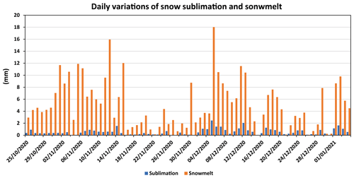
The daily variations of sublimation and snowmelt over the Tazaghrat plateau are reported in Fig. 4. The graph shows that the average daily rate of sublimation was 0.56 mm d−1, while the average daily rate of snowmelt was 5.14 mm d−1. The maximum amplitude of sublimation was observed to be 2.5 mm d−1, and the maximum amplitude of snowmelt was 18 mm d−1. These results can be explained by various factors. The rate of sublimation is influenced by temperature, humidity, and wind speed. Higher temperatures and lower humidity levels can increase the rate of sublimation, while stronger winds can enhance the transport of water vapor away from the snow surface, resulting in increased sublimation. On the other hand, the rate of snowmelt is mainly driven by temperature, solar radiation, and precipitation. Warmer temperatures and increased solar radiation can enhance snowmelt, while precipitation can either increase or decrease the rate of snowmelt depending on the form (rain or snow).
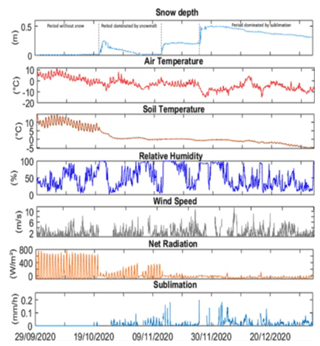
During our observation period, we identified three distinct phases, each with different dominant factors affecting sublimation rates. These phases included bare soil in September, a period dominated by snowmelt in October after the first snowfall, and finally, after two other snowfall events, a period dominated by sublimation in December (Fig. 5).
The comparison between the periods dominated by snowmelt or sublimation suggests that the sublimation period, characterized by strong wind speeds, low air temperatures, and high incident radiation, produced higher rates of sublimation and total sublimation than the snowmelt period. The rates of sublimation were 0.72 and 0.43 mm d−1 for the sublimation-dominated period and snowmelt-dominated period, respectively (Fig. 4).
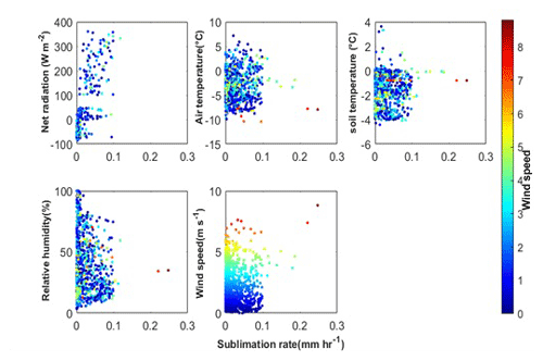
Figure 6Scatter plots of meteorological variables against sublimation rate, observed at Tazaghart station. The color of the data points refers to the observed wind.
To better understand the influence of meteorological variables on sublimation rates, we analyzed sublimation measurements in conjunction with different meteorological factors (Fig. 5). Our findings indicate that the highest relative snow sublimation fluxes occurred during subzero temperatures, low atmospheric humidity, and high wind speeds. In order to further investigate the role of wind speed in sublimation rates, we included it as a third variable in the scatter plots of meteorological variables (Fig. 6). Our results show that low sublimation values were recorded at subzero air temperatures and low wind speeds. The highest daily sublimation values of approximately 0.3 mm h−1 were obtained when wind speeds were high (around 11 m s−1) and air temperatures were near zero. However, warm air temperatures resulted in a decrease in snow sublimation, even with high wind speeds. Additionally, high humidity levels resulted in lower vapor pressure gradients near the surface, which subsequently led to lower sublimation rates. Overall, our results suggest that moderate to high wind speeds are necessary for significant sublimation to occur. These findings provide valuable insights into the complex interplay between meteorological variables and sublimation rates in the study area.
Based on the energy and water balance, calculated at a timestep of 30 min, the measured sublimation accounted for 42 % and 40 % of snow ablation respectively (Table 1). The estimated percentages are comparable, which supports the reliable measurements and provides validation of the Eddy covariance method. Using a modelling method, Chaponnière et al. (2005) and Boudhar et al. (2009) calculated sublimation in the northern High Atlas and discovered that it ranges between 16 % and 38 % of the total annual solid precipitation. Using a modelling method, Schulz and de Jong (2004) calculated that the drier southern slopes of the High Atlas sublimate around 45 % of the total precipitation.
The article describes a study conducted in the Tazaghart plateau in the High Atlas Mountains of Morocco to estimate sublimation and evapotranspiration processes. The study utilized an eddy-covariance flux station to estimate the energy balance and sublimation rates between September 2020 and January 2021. The preliminary data analyses show a diurnal sublimation cycle with a peak in the early afternoon and the highest relative snow sublimation fluxes that occurred with subzero temperatures, low atmospheric humidity, and high wind speeds. The study found that the Tazaghart plateau area is ideal for eddy covariance measurements, and the daily rate of sublimation was 0.56 mm d−1, while the daily rate of snowmelt was 5.14 mm d−1. Measured sublimation accounted for 42 % and 40 % of snow ablation, based on the energy and water balance respectively. The results show the ability of the Eddy covariance technic to quantify the direct measurements of winter water loss due to the sublimation of snowpack, especially in higher areas where measurements are relatively difficult and rare. It provides valuable insights into the hydrological processes in mountain areas and highlights the importance of accurately assessing sublimation in the overall hydrological cycle which can help inform water management strategies in semi-arid watersheds. Unfortunately, the altitude of the plateau, the very severe climatic conditions, and the difficulty of access limit the maintenance of this monitoring system on a permanent basis in these areas.
All raw data can be provided by the corresponding authors upon request.
LH, VS, and SG planned the campaign; LH, VS, and AC performed the measurements; LH, OL, SG, and AC analyzed the data; LH and OL wrote the manuscript draft; SG, VS, and AC reviewed and edited the manuscript.
The contact author has declared that none of the authors has any competing interests.
Publisher's note: Copernicus Publications remains neutral with regard to jurisdictional claims in published maps and institutional affiliations.
This article is part of the special issue “IAHS2022 – Hydrological sciences in the Anthropocene: Variability and change across space, time, extremes, and interfaces”. It is a result of the XIth Scientific Assembly of the International Association of Hydrological Sciences (IAHS 2022), Montpellier, France, 29 May–3 June 2022.
This paper was edited by Christophe Cudennec and reviewed by two anonymous referees.
Ault, T. W., Czajkowski, K. P., Benko, T., Coss, J., Struble, J., Spongberg, A., Templin, M., and Gross, C.: Validation of the MODIS snow product and cloud mask using student and NWS cooperative station observations in the Lower Great Lakes Region, Remote Sens. Environ., 105, 341–353, https://doi.org/10.1016/j.rse.2006.07.004, 2006.
Baba, M. W., Gascoin, S., and Hanich, L.: Assimilation of Sentinel-2 data into a snowpack model in the High Atlas of Morocco, Remote Sens., 10, 1–23, https://doi.org/10.3390/rs10121982, 2018.
Bosilovich, M. G.: A comparison of MODIS land surface temperature with in situ observations, Geophys. Res. Lett., 33, 1–5, https://doi.org/10.1029/2006GL027519, 2006.
Boudhar, A., Hanich, L., Boulet, G., Duchemin, B., Berjamy, B., and Chehbouni, A.: Evaluation of the Snowmelt Runoff model in the Moroccan High Atlas Mountains using two snow-cover estimates, Hydrol. Sci. J., 54, 1094–1113, https://doi.org/10.1623/hysj.54.6.1094, 2009.
Boudhar, A., Boulet, G., Hanich, L., Sicart, J. E., and Chehbouni, A.: Energy fluxes and melt rate of a seasonal snow cover in the Moroccan High Atlas, Hydrol. Sci. J., 61, 931–943, https://doi.org/10.1080/02626667.2014.965173, 2016.
Chaponnière, A., Maisongrande, P., Duchemin, B., Hanich, L., Boulet, G., Escadafal, R., and Elouaddat, S.: A combined high and low spatial resolution approach for mapping snow covered areas in the Atlas mountains, Int. J. Remote Sens., 26, 2755–2777, https://doi.org/10.1080/01431160500117758, 2005.
Dietz, A. J., Kuenzer, C., and Dech, S.: Global SnowPack: a new set of snow cover parameters for studying status and dynamics of the planetary snow cover extent, Remote Sens. Lett., 6, 844–853, https://doi.org/10.1080/2150704X.2015.1084551, 2015.
Hanich, L., Chehbouni, A., Gascoin, S., Boudhar, A., Jarlan, L., Tramblay, Y., Boulet, G., Marchane, A., Baba, M. W., Kinnard, C., Simonneaux, V., Fakir, Y., Bouchaou, L., Leblanc, M., Le Page, M., Bouamri, H., Er-Raki, S., and Khabba, S.: Snow hydrology in the Moroccan Atlas Mountains, J. Hydrol. Reg. Stud., 42, 101101, https://doi.org/10.1016/J.EJRH.2022.101101, 2022.
Liston, G. E. and Elder, K.: A distributed snow-evolution modeling system (snowmodel), J. Hydrometeorol., 7, 1259–1276, https://doi.org/10.1175/JHM548.1, 2006.
Reba, M. L., Pomeroy, J., and Danny Marks, D.: Estimating surface sublimation losses from snowpacks in a mountain catchment using eddy covariance and turbulent transfer calculations, Hydrol. Process., 26, 3699–3711, https://doi.org/10.1002/hyp.8372, 2012.
Schulz, O. and de Jong, C.: Snowmelt and sublimation: field experiments and modelling in the High Atlas Mountains of Morocco, Hydrol. Earth Syst. Sci., 8, 1076–1089, https://doi.org/10.5194/hess-8-1076-2004, 2004.


