the Creative Commons Attribution 4.0 License.
the Creative Commons Attribution 4.0 License.
 | 19 Apr 2024
Recharge and dynamics of the Tamanrasset alluvial aquifer (Algerian Sahara)
Samia Hadj-Said
Aziez Zeddouri
Jean-Denis Taupin
Nicolas Patris
Christian Leduc
Population growth and agricultural intensification are ever more demanding in water resources, and threaten their quality and quantity, especially in semi-arid and arid areas. The Sahara desert is typical of these multiple constraints and rapid changes making sustainable management of water resources a major issue. The wide regional aquifers have nearly fossil water. In contrast, alluvial aquifers associated with small wadis are recharged nearly each year by the rare floods. In the case of Wadi Tamanrasset, in southern Algeria, the alluvial aquifer is exploited intensively because of its accessibility and its good chemical quality. The physical conditions commanding flow and recharge of groundwater, and especially the transfer from surface to groundwater, were studied by combining hydrodynamics and isotopic tracers (18O, 2H). Monthly monitoring of groundwater level in around thirty wells was complemented by automatic recorders with hourly time steps since March 2016 in three wells, along a 600 m transect perpendicular to the wadi bed. The slow response of the water table is visible only two months after the first flood; its maximum rise was 1 m in 2016. Isotopic analyses of rainwater on a daily time scale, of the wadi water on a 1 h time scale during runoff and of groundwater (two complete campaigns in the dry and wet seasons and a specific monitoring of the transect every month) have provided additional information on surface-groundwater transfer.
- Article
(960 KB) - Full-text XML
- BibTeX
- EndNote


UPH13; Field observation; Arid areas; Hydrodynamics; Stable isotopes; Surface-groundwater interaction
The last periods of drought that have affected the Mediterranean region and the economic and demographic development in spite of the arid climate have increased the solicitation of groundwater resources in the Sahara. Groundwater, which is now very actively exploited, is often vulnerable both qualitatively and quantitatively. Future exploitation plans should therefore be preceded by a better identification of these fragile water resources.
Oxygen-18 and deuterium are excellent tracers of the water circulation, since they are not subject to fixation processes that affect even the best other chemical tracers. They give information on all stages of the water cycle, from the atmospheric vapor to groundwater. The isotopic fractionation depends mostly on temperature and environmental factors conditioning the various processes, especially condensation and evaporation (Shamsuddin et al., 2018).
Groundwater geochemistry in the Sahara was studied by various works (e.g. Saighi et al., 2001; Guendouz et al., 2003; Moulla et al., 2005) but the groundwater/river relationship is rarely investigated. This issue is the main purpose of this work.
Most of the water used in the city of Tamanrasset is groundwater, with a special interest of inhabitants for small alluvial aquifers because of their good quality. Groundwater is recharged by occasional floods of wadis whose upstream morphology is marked by steep slopes and narrow valleys.
In Tamanrasset, the wadi/aquifer relationship is still poorly known. The study of the stable isotopes of water allowed to identify the origin of the input signal to aquifers, to estimate the recharge altitudes and to define the relationships between groundwater and surface water. The analysis of piezometric fluctuations complemented this study of transfers between surface water and groundwater.
2.1 Geographic and climatic context
The study area (Fig. 1) is located in southern Algeria, between 22°10′ and 22°60′ N and between 5°32′ and 5°39′ E. It extends over an area of 106 km2 and is the downstream part of the much larger Wadi Tamanrasset catchment (about 500 km2). In this arid climate, rain may originate from the Sudan-Saharan monsoon whose extreme northern extension limit is the south of the Tademaït plateau, or from a few Mediterranean rain systems. Maximum values of rainfall are recorded at the Assekrem station (elevation of about 2700 m). Rain usually occurs between May and September (monsoon rain) but sporadic rains exist in winter and spring (Mediterranean or North Atlantic rainfall).
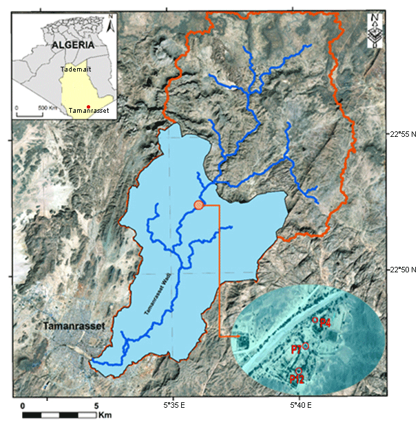
Figure 1The study area (light blue), downstream part of the Wadi Tamanrasset catchment (orange contour), and the transect location.
In 2016 the annual rainfall was 150 mm in Assekrem and 99 mm in Tamanrasset. The average annual temperature in Assekrem was 11.9 °C, and the hottest months were June and July (24.3 °C), while the coldest months were December and January (6.0 °C). In Tamanrasset, the average annual temperature was 23.4 °C.
2.2 Hydrological and geological context
The elevation of the study area varies mostly between 1350 and 1500 m. The upstream part of the Tamanrasset catchment consists of basaltic plateaus (near Assekrem, at a mean elevation of 2000 m a.s.l.) while the downstream sub-catchment is mostly made of granites.
The Tamanrasset wadi starts on the South side of the Atakor, in the region of Assekrem (highest peak at 2726 m a.s.l.), and then flows down along a SSW direction. It has nearly no tributaries on its left bank and very few on its right. The longitudinal profile of the wadi is quite regular, in spite of small discontinuities due to the presence of recent volcanic flows and crystalline sills. The wadi sometimes flows in very narrow gorges.
Upstream of these crystalline thresholds, the wadi may spread out and form small alluvial accumulations. The Tamanrasset plain is the largest of them.
A gauging test in the city of Tamanrasset during the flood of 11 May 2014 gave flow values between 0.5 and 5.24 m3 s−1 (Tarenga et al., 2015).
The main geological formations of the study area are the unaltered basement, alterites and the recent alluvium. The basement is made of granite, gneiss and micaschist, with frequent diaclases. The depth of altered bedrock varies significantly, depending on fracturation density and local uplift of harder rocks.
The aquifer is a notch in the gneissic and granitic basement. The water resource is mainly stored in coarse alluvial deposits resulting from the erosion of the Atakor massif. The geophysical study carried out in the area (Ben Elkheir et al., 2017; Zeddouri et al., 2018) identified four layers: dry coarse alluvium (gravel, pebbles and cobbles) at the surface and in sub-surface; medium to fine alluvium that may also contain groundwater; altered bedrock; and fresh bedrock, which is very resistant and can be met at a depth of up to 40 m. The hydrogeological system is composed of five consecutive alluvial basins, separated by sills corresponding to outcrops of the gneissic basement.
These alluviums, which offer a renewable resource irregularly fed by the few floods, have an average thickness of 21 m that decreases from upstream to downstream. The piezometric maps for March and September 2016 show a general flow that coincides with the course of the wadi.
In order to study groundwater recharge and its relationship with the wadi, an isotopic monitoring was carried out:
-
in precipitation: 16 rainfall events were sampled in 2016 at the Assekrem station (23.3° N; 5.6° E), among which one was discarded because of imperfect storage, and seven events in Tamanrasset (22.8° N, 5.5° E; elevation of 1376 m a.s.l.),
-
in the wadi: 31 samples from the four floods that occurred in 2016; each flood was sampled every 30 min,
-
in groundwater: 60 samples.
Oxygen 18 and deuterium were measured by mass spectrometry (IRMS Isoprime) at the LAMA laboratory of HydroSciences Montpellier (HSM). Results are expressed as delta values relative to the international standard VSMOW (Vienna Standard Mean Ocean Water) with errors of ±0.06 ‰ and ±0.8 ‰ for δ18O and δ2H, respectively.
The water table was monitored in three wells (P12, P7, P4) equipped with piezometric recorders at a hourly time step along a 600 m transect perpendicular to the wadi bed (Fig. 1).
4.1 Isotopic content of rainfall
The stable isotope content of rainfall water samples collected at the Assekrem station varied between −4.65 ‰ and +3.37 ‰ for δ18O, and −24.8 ‰ and +24.6 ‰ for δ2H. The deuterium excess varied between −7.6 ‰ and +16.6 ‰. Four rainfall events, with d-excess < +8 ‰ and relatively enriched isotope values, showed a clear evaporation process, either during rainfall or before sampling but in general the events show no evaporation process during the fall under the cloud, despite the small quantity sampled. The precipitation-weighted mean values were −3.65 ‰ for δ18O and −18.9 ‰ for δ2H (Table 1). The isotopic meteoric line at the Assekrem station is: δ2H = 4.2 δ18O + 1.2 (Fig. 2). Similar results were obtained by Saighi et al. (2001).
Table 1Isotopic content of rainfall events at the Assekrem station in 2016 (ND = no data).

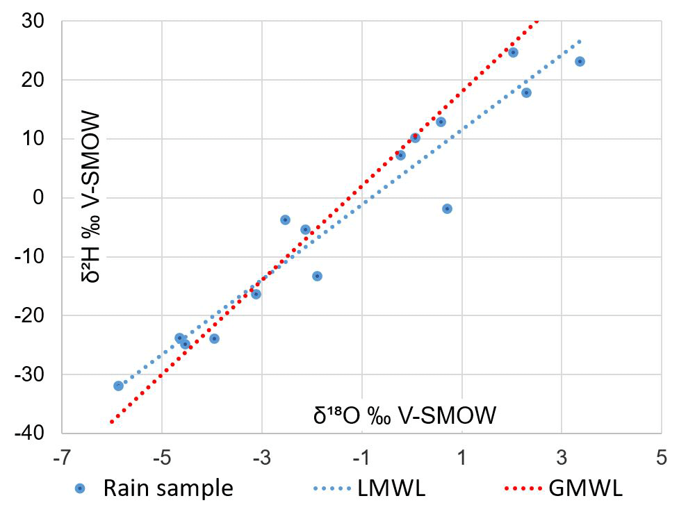
Figure 2Deuterium vs. oxygen-18 relationship of Assekrem rainwater in 2016 (Global and Local Meteoric Water Lines).
In the seven Tamanrasset events, the stable isotope of rainwater varied between −2.95 ‰ and +4.02 ‰ for δ18O and between −14.0 ‰ and +13.3 ‰ for δ2H. The deuterium excess varied between −23.8 ‰ and +9.7 ‰. The annual precipitation-weighted mean in Tamanrasset was +0.13 ‰ for δ18O and +1.2 ‰ for δ2H.
The Tamanrasset meteoric line is marked by a greater evaporation process in four events: δ2H = 3.22 δ18O + 0.5 but its representativeness is limited by the weak number of events sampled.
The isotopic data of rainwater showed temporal variations. Precipitation at the beginning and end of the rainy season was more enriched than the heavier rainfall in the middle of the rainy season (July to August) which had more depleted values. Such evolution can be attributed to the saturation state of the atmosphere at the time of precipitation, and the mass effect and low atmospheric temperature during strong thunderstorms.
The variation of the annual weighted mean δ18O in precipitation highlights the altitude effect that leads to a depletion of heavy isotopes in precipitation due to lower condensation temperatures.
4.2 Isotopic content of the wadi water
In the wadi water, δ18O ranged from −3.72 ‰ to +0.70 ‰ and δ2H from −21 ‰ to +10 ‰. Isotope variations during the flood (3 to 24 h) were rather limited, showing a good mixing of rainfall in the wadi water. Floods are generated in the highest part of mountainous zone, except maybe for the 17 July flood where no rainfall was measured concurrently in the Assekrem station. The isotopic value in the wadi for this event was close to the isotopic value of rain at the Tamanrasset station. However, only one flood event (21 July) can be directly linked with Assekrem in isotope terms, indicating that the wadi is fed by the whole catchment with its own isotope variability due to altitude, to condensation levels and origin of the convective rainfall. No evaporation process marked the floods during the wet season (July and August) (Table 2). Thus, it can be concluded that the surface water of the Wadi Tamanrasset basin is strongly affected by precipitation at higher elevations.

4.3 Isotopic content of groundwater
In groundwater collected in March 2016 δ18O ranged from −3.79 ‰ to −1.55 ‰, and δ2H from −24.8 ‰ to −7.5 ‰. In groundwater sampled in August 2016 δ18O ranged from −4.19 ‰ to −1.64 ‰ and δ2H varied between −23.7 ‰ and −6.4 ‰. The isotopic composition of groundwater sampled in March 2016 was similar to wadi water indicating that the source of groundwater is related to the wadi water. The isotopic composition of groundwater varies, depending on the isotopic signature of the recharge water. Since recharge needs some time to reach the water table, the isotopic composition in March would be affected by the various previous events. In the high-water season, the signatures in groundwater are more depleted than those collected in the low water season corresponding to the flooding of the wadi originating in the Assekrem rain.
4.4 Interactions between groundwater and wadi
Contrary to expectation, the three wells equipped with automatic recorders did not show individual signals of flood but rose progressively by about 1 m with a phase shift of two months after the first flood and a stabilization one month after the last flood (Fig. 3). The delayed response of the flood effect on the piezometric level may be due to (i) the important thickness of the unsaturated zone which can reach 15 m, (ii) the large amount of clays in the alluvium according to the granulometric analyses and the measurements of electrical resistivity (Zeddouri et al., 2018). The annual recharge for 2016 was estimated at about 21 hm3.

This study aimed at determining the main components of the recharge of the alluvial aquifer and especially the wadi-alluvium connection, with the help of stable isotopes and piezometric measurements. Isotopic content of rainwater varied seasonally, with more enriched events in the core of the thunderstorms season. The annual weighted means of 18O in precipitation in the two stations of Assekrem and Tamanrasset highlighted the effect of altitude. The isotopic signature in groundwater was similar to that of the wadi floods originating from the rainfall in Assekrem. Automatic recorders of the groundwater level showed a slow velocity of the wadi/groundwater transfer during the two months of September and October making the level of the groundwater progressively rise by over 1 m. This slow response of the water table is explained by the low permeability of the unsaturated zone because of clays in the alluvium and by its thickness (up to 15 m).
A more complete formulation of data used in this paper may be requested from the first author.
SHS and AZ contributed to the field activities; JDT and NP contributed to the isotopic analyses; all co-authors contributed to the data interpretation and paper writing.
The contact author has declared that none of the authors has any competing interests.
Publisher’s note: Copernicus Publications remains neutral with regard to jurisdictional claims in published maps and institutional affiliations.
This article is part of the special issue “IAHS2022 – Hydrological sciences in the Anthropocene: Variability and change across space, time, extremes, and interfaces”. It is a result of the XIth Scientific Assembly of the International Association of Hydrological Sciences (IAHS 2022), Montpellier, France, 29 May–3 June 2022.
We thank the LAMA laboratory of Hydrosciences Montpellier (France) for the isotopic analyses.
This research has been supported by the French-Algerian PHC TASSILI funding (grant no. 16MDU961) led by IRD/University of Montpellier (France) and the RSPGA laboratory of University Kasdi Merbah-Ouargla (Algeria).
This paper was edited by Christophe Cudennec and reviewed by Mohammad Merheb and one anonymous referee.
Ben Elkheir, A., Zeddouri, A., Hadj-Said, S., Satouh, A., Taupin, J.-D., Leduc, C., and Patris, N.: Configuration du système aquifère de la région de Tamanrasset (Sud de l'Algérie) : application des méthodes géophysiques à l'établissement d'un schéma conceptuel, J. Int. Sci. Technique Eau Env., 2, 21–24, 2017.
Guendouz, A., Moulla, A. S., Edmunds, W. M., Zouari, K., Shand, P., and Mamou, A.: Hydrogeochemical and isotopic evolution of water in the Complexe Terminal aquifer in the Algerian Sahara, Hydrogeol. J., 11, 483–495, https://doi.org/10.1007/s10040-003-0263-7, 2003.
Moulla, A. S., Guendouz, A., Reghis, Z., Chaid, Z., Larbes, M., Ouarezki, S., and Rezka, A.: Un aperçu de quelques résultats d'hydrologie isotopique importants obtenus au Sahara algérien, in: Colloque International sur les Ressources en Eau au Sahara, 13 December 2005, Ouargla, Algérie, Agence de Bassin Hydrographique du Sahara, 12 pp., 2005.
Saighi, O., Michelot, J. L., and Filly, A.: Isotopic characteristics of meteoric water and groundwater in Ahaggar massif (Central Sahara), International Atomic Energy Agency, Vienna, Austria, TEC-DOC no. 1207, 7–25, https://inis.iaea.org/collection/NCLCollectionStore/_Public/32/018/32018317.pdf?r=1 (last access: 25 August 2023), 2001.
Shamsuddin, M. K. N., Sulaiman, W. N. A., Ramli, M. F., Kusin, F. M., and Samuding, K.: Assessments of seasonal groundwater recharge and discharge using environmental stable isotopes at Lower Muda River Basin, Malaysia, Appl. Water Sci., 8, 120, https://doi.org/10.1007/s13201-018-0767-x, 2018.
Tarenga, L., Hadj-Said, S., Zeddouri, A., Ben Elkheir, A., and Taupin, J. D.: Alluvial groundwater a vulnerable resource in arid zone, First International Conference on the Hydrology of Large African Rivers, Hammamet, Tunisia, 2015.
Zeddouri, A., Ben Elkheir, A., Hadj-Said, S., Taupin, J. D., Leduc, C., and Patris, N.: Analysis and interpretation of electrical resistivity tomography data of alluvial aquifer of Tamanrasset Southern Algeria, in: Technologies and materials for renewable energy, environment and sustainability, edited by: Salam, C. T., Aillerie, M., Papageorgas, P., Haider, A. J., Vokas, G., and Jabur, A. R., TMREES18 conference in Beyrouth, Lebanon, 1 February 2018, AIP Conference Proceedings 1968, AIP Publ., New York, USA, 020024-1-020024-8, ISBN 978-0-7354-1675-8, 2018.