the Creative Commons Attribution 4.0 License.
the Creative Commons Attribution 4.0 License.
 | 19 Apr 2024
Runoff uncertainty associated with global climate model chosen in regional climate modeling
Salah Basem Ajjur
Sami G. Al-Ghamdi
Uncertain climatic projections result in uncertain runoff predictions, which lead to unreliable water resources management and floods mitigation measures. This study investigates runoff uncertainty associated with Global Climate Models (GCMs) chosen as boundary conditions in regional climate models (RCMs). To this end, the study projected surface air temperature, precipitation, wind speed, and potential evapotranspiration, over Qatar, from the Massachusetts Institute of Technology (MIT) RCM driven by three GCMs: CCSM4, MPI-ESM, and NorESM. Historical projections were made during 1976–2005 while future projections were made during 2071–2100 under the business-as-usual Representative Concentration Pathways (RCP8.5). The study then inputs climatic parameters in addition to topographic and groundwater data, in a physically based water balance model to compare runoff simulations. During historical and future periods, climatic projections differed among the RCM runs, especially precipitation and potential evapotranspiration. Uncertainty in climatic projections caused significant uncertainty in runoff estimations. Runoff estimations varied from 12.2 to 45 Mm3 yr−1, with an average value of 24.4 Mm3 yr−1 during 1976–2005, and from 12.3 to 52.4 Mm3 yr−1, with an average value of 32.4 Mm3 yr−1 during 2071–2100. All RCM runs agreed on future runoff increases. Since runoff is a main cause of floods and alleviating flood risk can be hindered if climatic projections are incompetent, the study's findings emphasize on narrowing the uncertainty in GCM projections. The study also encourages Qatar authorities to implement managed aquifer recharge projects like rainwater harvesting to alleviate floods risk.
- Article
(2430 KB) - Full-text XML
- BibTeX
- EndNote


Floods; modeling uncertainty; climate models; RCMs; Qatar
Accurate estimation of the hydrologic cycle components is essential for water resources management and climate change mitigation and adaptation strategies (Pozdniakov et al., 2020; Xie et al., 2018; Anibas et al., 2016). Previous literature, therefore, tried to identify and narrow the uncertainty while estimating hydrologic cycle components. Among these components, runoff uncertainty is a big concern. Surface runoff cannot be measured on a large scale. Overestimate runoff may lead to significant losses in water requirements, whereas underestimated runoff can lead to severe damaging floods (Xie et al., 2018; Moiwo et al., 2010; Ahmed et al., 2018). Therefore, significant efforts have been devoted to exploring runoff uncertainty and enabling getting reliable estimations. The focus was on surface parameters and groundwater inputs (Xie et al., 2018; Martos-Rosillo et al., 2015). Though, a key source of runoff uncertainty might be climatic inputs. Accordingly, this study quantifies and compares runoff simulations obtained from implementing different climatic inputs but same topographic and groundwater conditions in a constructed calibrated water balance model (i.e., WetSpass) in Qatar. WetSpass is a common, reliable physically based model that utilizes the water balance concept at grid points to simulate surface runoff, groundwater recharge, and actual evapotranspiration (Ajjur and Mogheir, 2012; Mogheir and Ajjur, 2013; Batelaan and De Smedt, 2007; Moiwo et al., 2010). WetSpass relates runoff to precipitation amount and intensity, interception fraction, and soil infiltration capacity. The interception fraction varies based on the land cover and represents a constant ratio of annual precipitation.
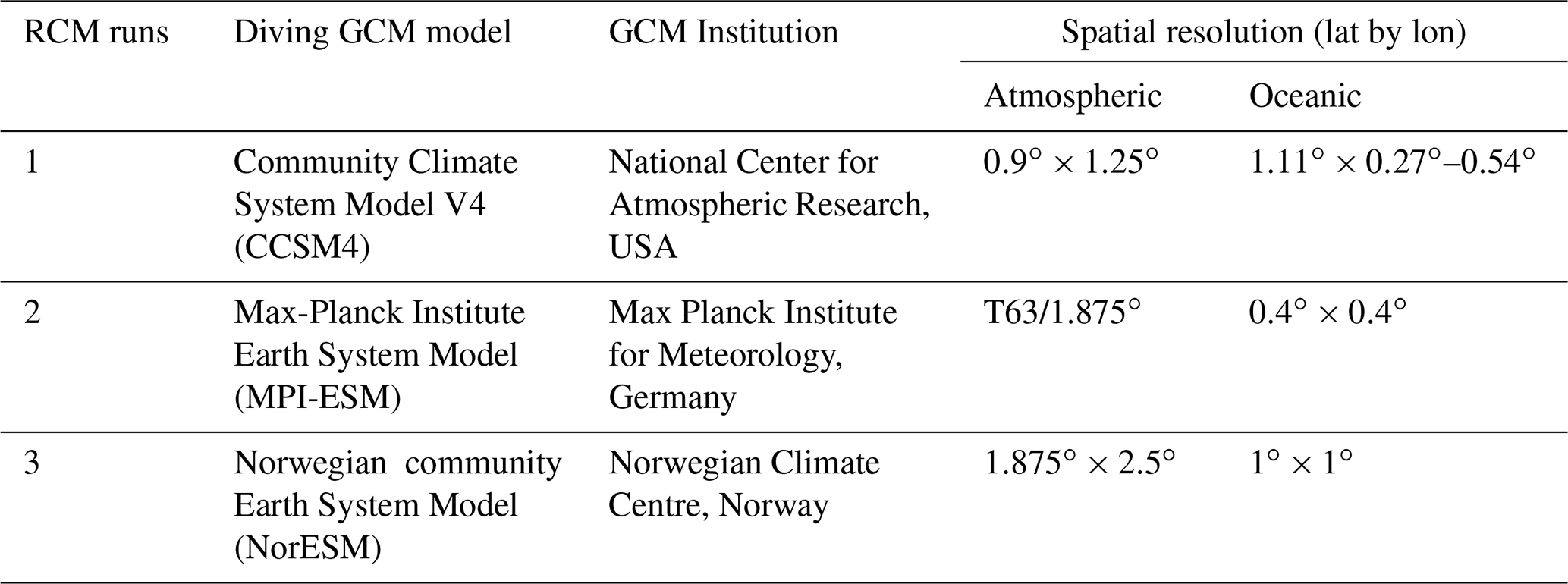
This study obtained Qatar's topographic and groundwater data from the Ministry of Municipality and Environment. The study uses the Massachusetts Institute of Technology (MIT) Regional Climate Model (RCM) for climatic inputs. The MIT RCM has proven its reliability over southwest Asia at a 25-km spatial resolution (Pal and Eltahir, 2016). It uses three Global Climate Models (GCMs) as atmospheric boundary conditions. Table 1 tabulates information on these GCMs and their horizontal resolutions. The three GCMs were selected based on objective criteria of their representation of regional water bodies (read further details on these criteria in Pal and Eltahir, 2016). For the purpose of this study, the spatial resolution of the MIT RCM has been improved, over Qatar, from 25 to 12.5 km, and the MIT RCM has been run under the three GCMs boundary conditions, producing three runs' outputs during historical and future climates.
Table 1Information on the three GCMs used as the boundary condition for the MIT RCM.
Case study description
Qatar is a country in the eastern Arabian Peninsula, encompassing an area of 11 650 km2. The elevation changes from zero at coasts to up to 92 m above mean sea level in the southwestern parts (Ajjur et al., 2021). There is has no surface water, and potable and industrial water needs are filled through seawater desalination (Ajjur and Baalousha, 2021; Ajjur and Al-Ghamdi, 2022). The climate is hyper-arid, with an average long-term maximum temperature of 35 °C and a long-term annual rainfall of 77 mm. Qatar, and the Arabian Peninsula in general, aridity and warming trend are expected to increase through the 21st century (Ajjur and Al-Ghamdi, 2021a, b, c; Al-Humaiqani and Al-Ghamdi, 2022; Serdar et al., 2022), with a possible link to global teleconnection patterns (Ajjur and Al-Ghamdi, 2021d; Ajjur and Riffi, 2020).
There are three main aquifers in Qatar distributed in the northern, southern, and southwest areas. Among these aquifers, the northern aquifer gets higher recharge from rainfall, and hence has better quality. During the last three decades, Qatar aquifers have been recently overexploited due to population growth, urbanization, and climate change impacts, which intensified some managed aquifer recharge initiatives to improve aquifers' quality and storage (Ajjur and Baalousha, 2021; Ajjur and Mogheir, 2019).
The study methodology includes three steps to investigate runoff uncertainty associated with driven GCM chosen in RCM. First, historical and future climatic parameters were projected from the MIT RCMs. The projected parameters included average air temperature, precipitation, wind speed, and potential evapotranspiration. The historical period was considered 1976–2005, while future period was regarded as the end-21st century (2071–2100) under the business-as-usual greenhouse gas emission Representative Concentration Pathways (RCP8.5). The RCP8.5 denotes 8.5 Watt per m2 of radiative forcing in 2100 relative to the pre-industrial period (1850–1900). Mean monthly values of temperature and wind speed were computed to get seasonal averages, while precipitation and potential evapotranspiration data were aggregated to get seasonal sum during both historical and future periods. Summer was represented between April and September, whereas the months between October and March represented winter. Second, topographic, groundwater, slope, and land use maps were prepared, and, together with climatic maps, all components were applied in WetSpass. Land use and soil type maps were connected with WetSpass as attribute tables. WetSpass analysis was performed for summer and winter. Seasonal runoffs were then summed to obtain yearly rates. Third, runoff volumes were approximated using GIS spatial analyst tools, and runoff direction was investigated in each run.
This section first describes how climatic parameters, projected from the three RCM runs, varied during the historical and future periods. It then shows how annual runoff simulations differed according to the variations in these climatic inputs.
3.1 Historical and future climate in Qatar
Figure 1 illustrates the differences among the three RCMs when projecting the mean climate over Qatar during the historical and future periods. In both periods, RCM runs projected similar temperature and wind speed values but different precipitation and potential evapotranspiration. For instance, mean annual precipitation varied among RCM runs from 26 to 64 mm (24 to 58 mm) during the historical (future) period. Similarly, annual potential evapotranspiration varied between 91 and 189 mm during the historical period and between 125 and 276 mm during the future period. These results agree with previous literature (Ajjur and Al-Ghamdi, 2021e, f) and can be attributed to two reasons: (1) there is a poor representation of rainfall, and potential evapotranspiration in GCMs over the Arabian Peninsula (Ajjur and Al-Ghamdi, 2021a), and (2) uncertainty in temperature and precipitation projections led to potential evapotranspiration uncertainty.
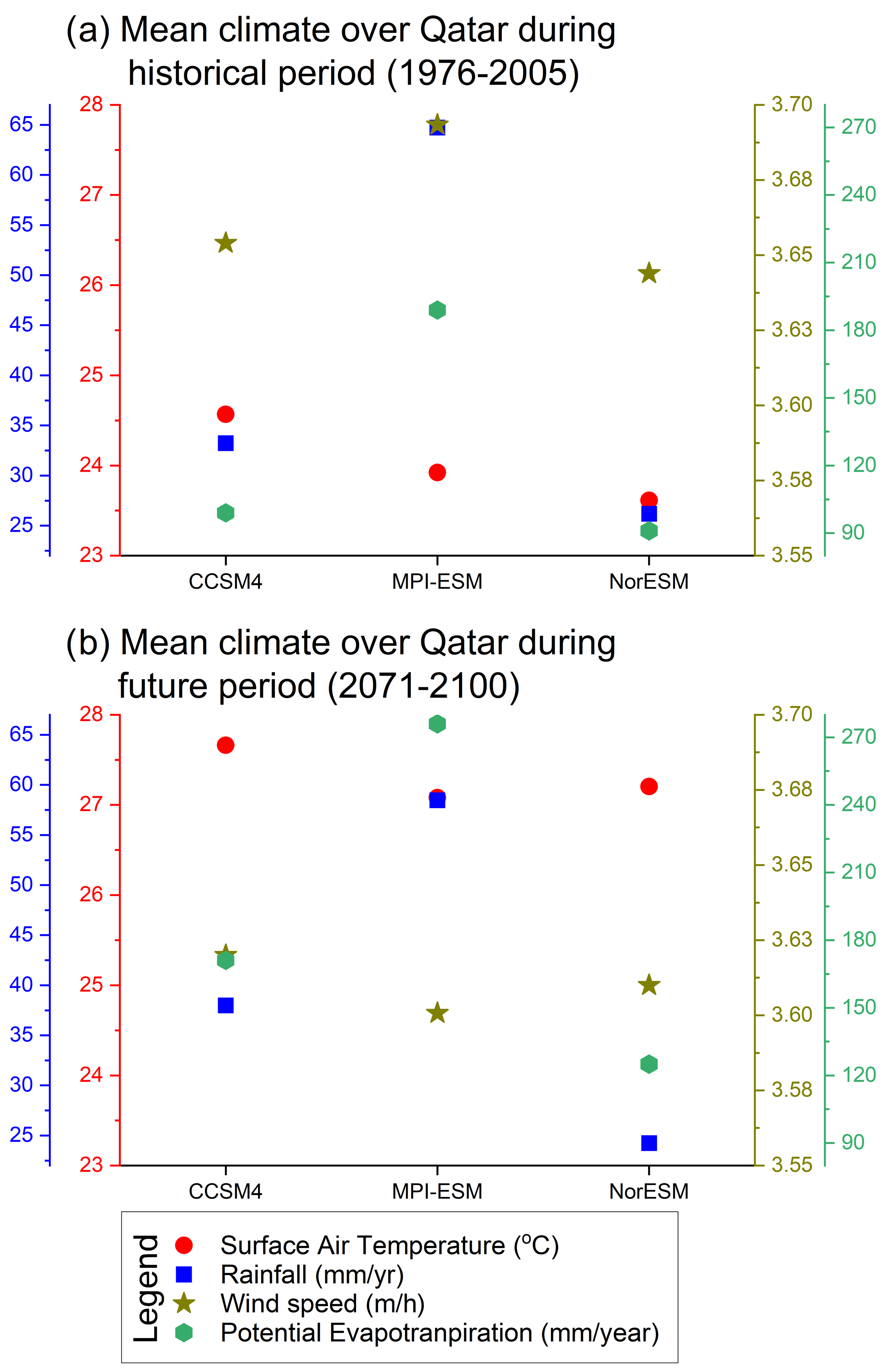
Figure 1Mean projected climatic parameters from the three MIT RCM runs for average air temperature; wind speed; precipitation; and potential evapotranspiration over Qatar during the historical and future periods.
The RCMs agreed on temperature increases of 3 to 3.6 °C and potential evapotranspiration increases of 33 to 86 mm3 yr−1, under RCP8.5, relative to the historical period. However, RCMs disagree on the future trend of precipitation (compare blue boxes in Fig. 1a and b). While CCSM4 projected a small increase in precipitation, both RCMs (MPI-ESM and NorESM) projected precipitation decreases. The future evolution of wind speed was negligible in all RCM runs. On average, the MIT RCM projected an overall increase of 3.28 °C in average air temperature and an increase of 64 mm in annual potential evapotranspiration under RCP8.5, relative to the historical period.
3.2 Runoff simulation
The previous section showed substantial uncertainty among RCM runs when projecting Qatar's climate during historical and future periods. It is still unclear whether this uncertainty could lead to uncertainty in runoff simulations. To investigate this, WetSpass analysis was performed, and runoff simulations obtained from the RCM runs were compared during the historical and future periods (Fig. 2). Runoff values varied up to 22 mm3 yr−1 in all RCM runs, except the MPI-ESM where maximum runoff hit 63 mm3 yr−1 in the historical period and 72 mm3 yr−1 in the future period (see eastern parts in Fig. 2b and e). Worth notably that the MPI-ESM projected higher precipitation than other runs, producing larger values of runoff. Some spatial uniformity is found between runoff simulations. Urban areas in the metropolitan Doha, represented by the eastern coastal part, received higher runoff since these areas are mainly composed of impervious surfaces. Impervious surfaces hinder groundwater recharge, forcing excess precipitation to flow at the land surface (Batelaan and De Smedt, 2007; Moiwo et al., 2010).
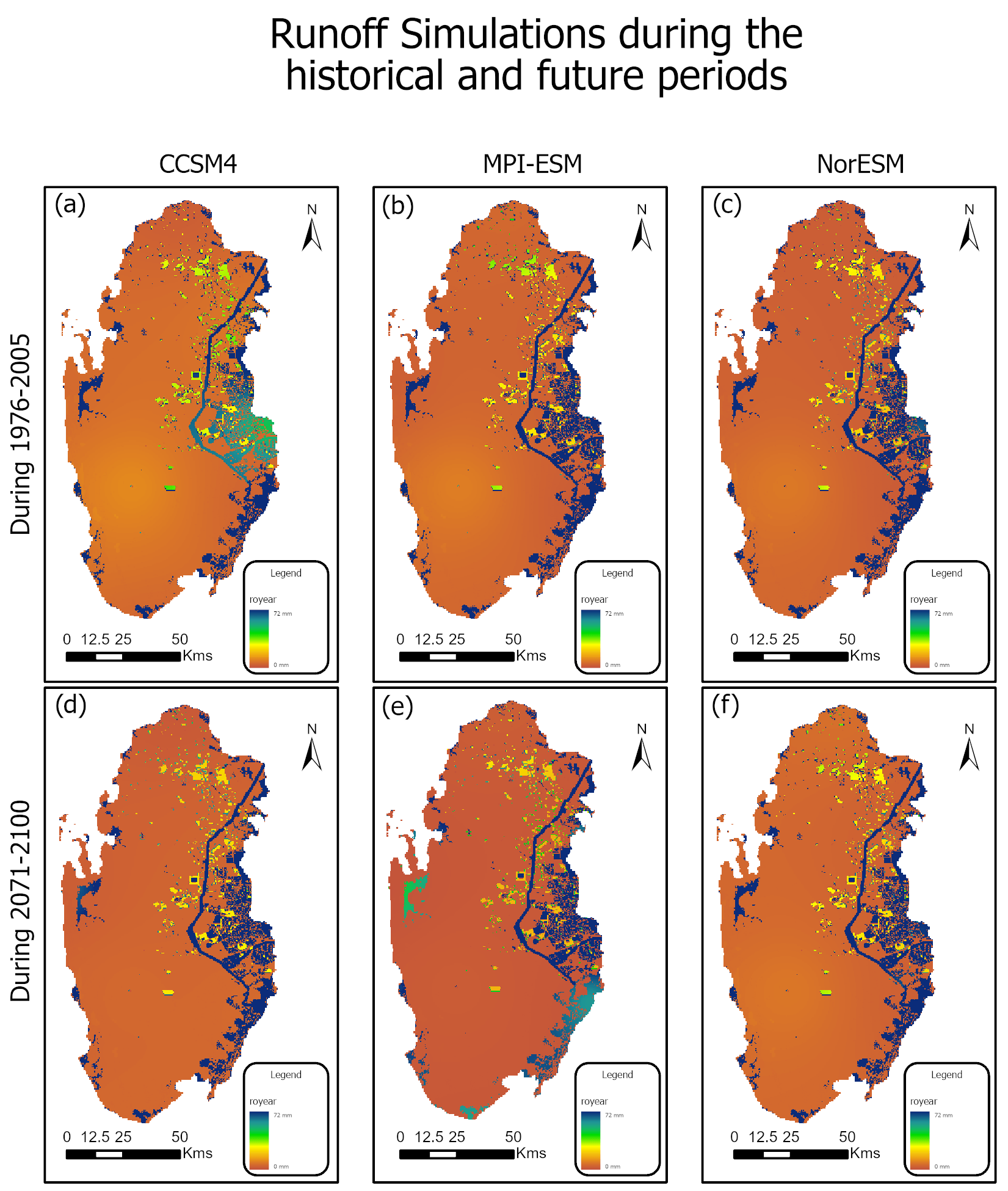
Figure 2Annual runoff simulations during the historical (a–c) and end-21st century (d–f) periods simulated using RCM runs inputs. Future simulations are under RCP8.5.
To quantify the variations in runoff simulations, spatial analysis tools were used to compute runoff volumes in all runs. Figure 3 depicts Qatar runoff volumes simulated by WetSpass using RCM runs inputs. The simulated runoff ranged from 12.2 to 45 Mm3 yr−1, with an average value of 24.8 Mm3 yr−1 during the historical period. Future simulations ranged from 12.3 to 52.4 Mm3 yr−1, with an average value of 32.4 Mm3 yr−1. All runs agreed on future runoff increases, however minimal increase was simulated under NorESM. During 2071–2100, runoff volumes increased by 91 % in CCSM4 and by 16 % in MPI-ESM relative to 1976–2005.
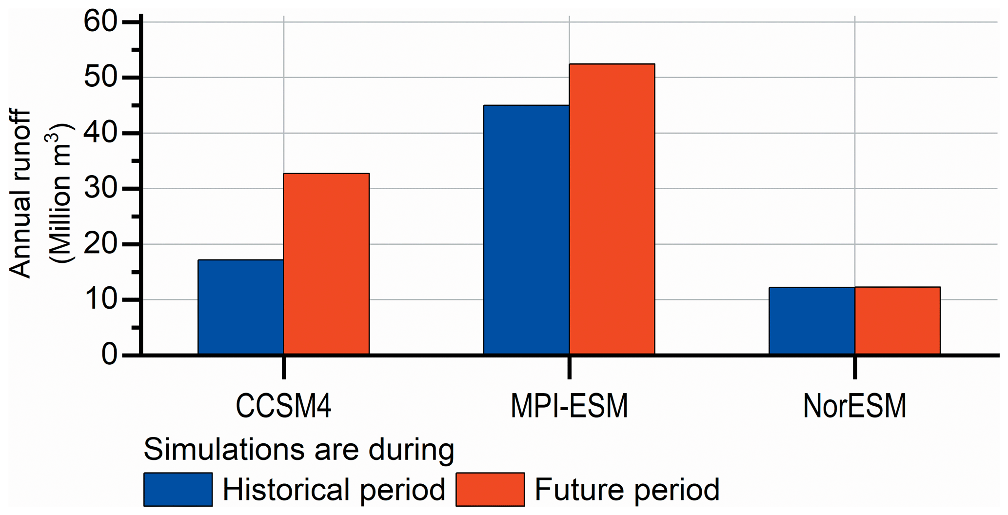
Figure 3Annual runoff volumes, in Million m3, simulated using RCM runs inputs during the historical period (1976–2005) and the end-21st century (2071–2100) under RCP8.5.
The presented study used climatic inputs from the same RCM version that three different GCMs drive. It then follows on previous work by investigating the uncertainty resulting from the driving GCM model. Runoff estimations simulated using these inputs showed substantial changes, ranging from 12.2 to 45 Mm3 yr−1 during 1976–2005 and from 12.3 to 52.4 Mm3 yr−1 during 2071–2100. Qatar is a hyper-arid area receives a minimal rainfall of 77 mm3 yr−1 on average. Therefore, the uncertainty in runoff simulations matters. Such uncertainty can hinder characterizing the magnitude and the direction of current and future runoff, posing questions on water resources management and climate change adaptation and mitigation measures. Therefore, it is paramount that researchers in the climate community devote serious efforts to narrow the uncertainty in GCMs.
Regarding Qatar, local authorities are highly encouraged to implement managed aquifer recharge systems like rainwater harvesting. This is an optimal way to benefit from runoff and alleviate floods risk on people, assets, and the built-up environment.
Topographic and groundwater data are available under reasonable request from the Qatar Ministry of Municipality and Environment.
SA: Conceptualization, Methodology, Data curation, Formal analysis, Validation, Visualization, Writing-original draft, and Writing-review and editing. SGAG: Conceptualization, Funding acquisition, Project administration, and Writing—review and editing.
The contact author has declared that neither of the authors has any competing interests.
Publisher’s note: Copernicus Publications remains neutral with regard to jurisdictional claims in published maps and institutional affiliations.
This article is part of the special issue “IAHS2022 – Hydrological sciences in the Anthropocene: Variability and change across space, time, extremes, and interfaces”. It is a result of the XIth Scientific Assembly of the International Association of Hydrological Sciences (IAHS 2022), Montpellier, France, 29 May–3 June 2022.
The authors thank Elfatih Eltahir from Massachusetts Institute of Technology and Jeremy Pal from Loyola Marymount University for providing MIT climatic data. This work was made possible through a National Priorities Research Program (NPRP) grant (NPRP12S-0212-190073) from the Qatar National Research Fund (QNRF), a member of Qatar Foundation (QF) to Sami Al-Ghamdi and a PhD scholarship from Hamad Bin Khalifa University (HBKU), a member of QF, to Salah Ajjur.
This research has been supported by the National Priorities Research Program from the Qatar National Research Fund (QNRF), a member of Qatar Foundation (QF) (grant no. NPRP12S-0212-190073).
This paper was edited by Christophe Cudennec and reviewed by two anonymous referees.
Ahmed, F., Moors, E., Khan, M. S. A., Warner, J., and Terwisscha van Scheltinga, C.: Tipping points in adaptation to urban flooding under climate change and urban growth: The case of the Dhaka megacity, Land Use Policy, 79, 496–506, https://doi.org/10.1016/j.landusepol.2018.05.051, 2018.
Ajjur, S. B. and Al-Ghamdi, S. G.: Evapotranspiration and water availability response to climate change in the Middle East and North Africa, Clim. Change, 166, 1–19, https://doi.org/10.1007/s10584-021-03122-z, 2021a.
Ajjur, S. B. and Al-Ghamdi, S. G.: Seventy-year disruption of seasons characteristics in the Arabian Peninsula, Int. J. Climatol., 41, 5920–5937, https://doi.org/10.1002/joc.7160, 2021b.
Ajjur, S. B. and Al-Ghamdi, S. G.: Global Hotspots for Future Absolute Temperature Extremes From CMIP6 Models, Earth Space Sci., 8, e2021EA001817, https://doi.org/10.1029/2021EA001817, 2021c.
Ajjur, S. B. and Al-Ghamdi, S. G.: Variation in Seasonal Precipitation over Gaza (Palestine) and Its Sensitivity to Teleconnection Patterns, Water, 13, 667, https://doi.org/10.3390/w13050667, 2021d.
Ajjur, S. B. and Al-Ghamdi, S. G.: Evapotranspiration and water availability response to climate change in the Middle East and North Africa, Clim. Change, 166, 1–19, https://doi.org/10.1007/s10584-021-03122-z, 2021e.
Ajjur, S. B. and Al-Ghamdi, S. G.: Seventy-year disruption of seasons characteristics in the Arabian Peninsula, Int. J. Climatol., 41, 5920–5937, https://doi.org/10.1002/joc.7160, 2021f.
Ajjur, S. B. and Al-Ghamdi, S. G.: Towards sustainable energy, water and food security in Qatar under climate change and anthropogenic stresses, Energy Reports, 8, 514–518, https://doi.org/10.1016/j.egyr.2022.02.099, 2022.
Ajjur, S. B. and Baalousha, H. M.: A Review on Implementing Managed Aquifer Recharge in the Middle East and North Africa Region: Methods, Progress, and Challenges, Water Int., 46, 578–604, https://doi.org/10.1080/02508060.2021.1889192, 2021.
Ajjur, S. B. and Mogheir, Y.: Effects of Climate Change on Groundwater Resources, The 4th International Engineering Conference-Towards engineering of 21st century, Gaza, Palestine, 2012.
Ajjur, S. B. and Mogheir, Y. K.: Identification of intrinsic suitable sites in Gaza Strip for the application of artificial groundwater recharge using a geographic information system multicriteria decision analysis, Journal of Multi-Criteria Decision Analysis, 27, 255–265, https://doi.org/10.1002/mcda.1701, 2019.
Ajjur, S. B. and Riffi, M. I.: Analysis of the observed trends in daily extreme precipitation indices in Gaza Strip during 1974–2016, Int. J. Climatol., 40, 6189–6200, https://doi.org/10.1002/joc.6576, 2020.
Ajjur, S. B., Al-Ghamdi, S. G., and Baalousha, H. M.: Sustainable Development of Qatar Aquifers Under Global Warming Impact, Int. J. Global Warm., 25, 323–338, https://doi.org/10.1504/IJGW.2021.119003, 2021.
Al-Humaiqani, M. M. and Al-Ghamdi, S. G.: The built environment resilience qualities to climate change impact: Concepts, frameworks, and directions for future research, Sustain. Cities Soc., 80, 103797, https://doi.org/10.1016/j.scs.2022.103797, 2022.
Anibas, C., Schneidewind, U., Vandersteen, G., Joris, I., Seuntjens, P., and Batelaan, O.: From streambed temperature measurements to spatial-temporal flux quantification: using the LPML method to study groundwater-surface water interaction, Hydrol. Process., 30, 203–216, https://doi.org/10.1002/hyp.10588, 2016.
Batelaan, O. and De Smedt, F.: GIS-based recharge estimation by coupling surface–subsurface water balances, J. Hydrol., 337, 337–355, https://doi.org/10.1016/j.jhydrol.2007.02.001, 2007.
Martos-Rosillo, S., González-Ramón, A., Jiménez-Gavilán, P., Andreo, B., Durán, J. J., and Mancera, E.: Review on groundwater recharge in carbonate aquifers from SW Mediterranean (Betic Cordillera, S Spain), Environ. Earth Sci., 74, 7571–7581, https://doi.org/10.1007/s12665-015-4673-3, 2015.
Mogheir, Y. and Ajjur, S.: Effects of climate change on groundwater resources (Gaza strip case study), Int. J. Sustain. Energy Environ., 1, 136–149, 2013.
Moiwo, J. P., Yang, Y., Li, H., Han, S., and Yang, Y.: Impact of water resource exploitation on the hydrology and water storage in Baiyangdian Lake, Hydrol. Process., 24, 3026–3039, https://doi.org/10.1002/hyp.7716, 2010.
Pal, J. S. and Eltahir, E. A. B.: Future temperature in southwest Asia projected to exceed a threshold for human adaptability, Nature Clim. Change, 6, 197–200, https://doi.org/10.1038/nclimate2833, 2016.
Pozdniakov, S. P., Vasilevsky, P. Y., Grinevskiy, S. O., Lekhov, V. A., Sizov, N. E., and Wang, P.: Variability in spatial–temporal recharge under the observed and projected climate: A site-specific simulation in the black soil region of Russia, J. Hydrol., 590, 125247, https://doi.org/10.1016/j.jhydrol.2020.125247, 2020.
Serdar, M. Z., Koç, M., and Al-Ghamdi, S. G.: Urban Transportation Networks Resilience: Indicators, Disturbances, and Assessment Methods, Sustain. Cities Soc., 76, 103452, https://doi.org/10.1016/j.scs.2021.103452, 2022.
Xie, Y., Cook, P. G., Simmons, C. T., Partington, D., Crosbie, R., and Batelaan, O.: Uncertainty of groundwater recharge estimated from a water and energy balance model, J. Hydrol., 561, 1081–1093, https://doi.org/10.1016/j.jhydrol.2017.08.010, 2018.