Articles | Volume 385
https://doi.org/10.5194/piahs-385-313-2024
Post-conference publication
 | 
19 Apr 2024
Post-conference publication |  | 19 Apr 2024

Analysis of rainfed cereal-legume mixture cropping water productivity in Lebna catchment, Cap-Bon, Tunisia

Insaf Mekki, Rim Zitouna-Chebbi, Salah Benyoussef, Aya Benabdelghaffar, Mariem Boukari, Frédéric Jacob, and Jean Albergel
Abstract

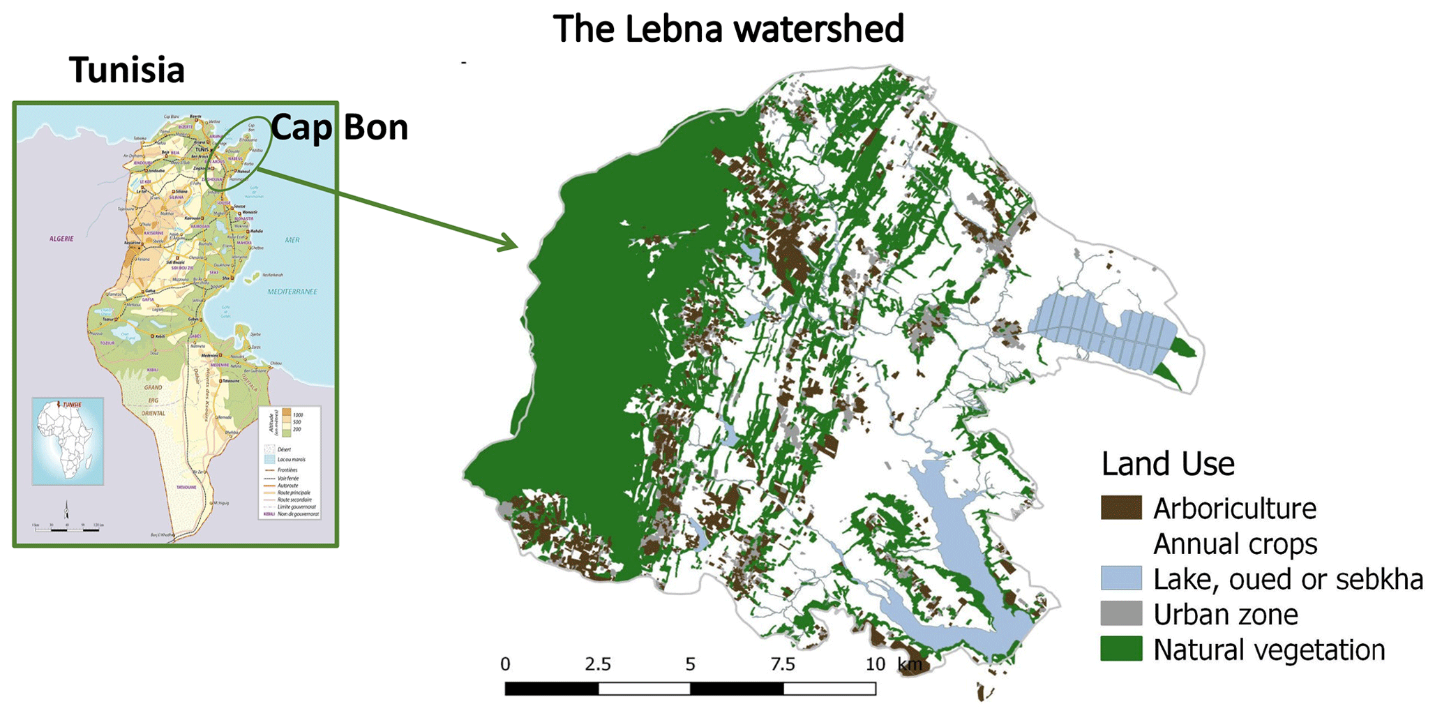
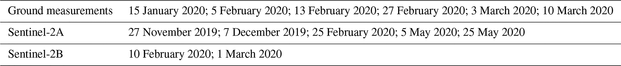
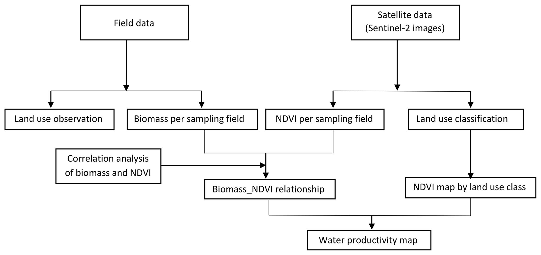
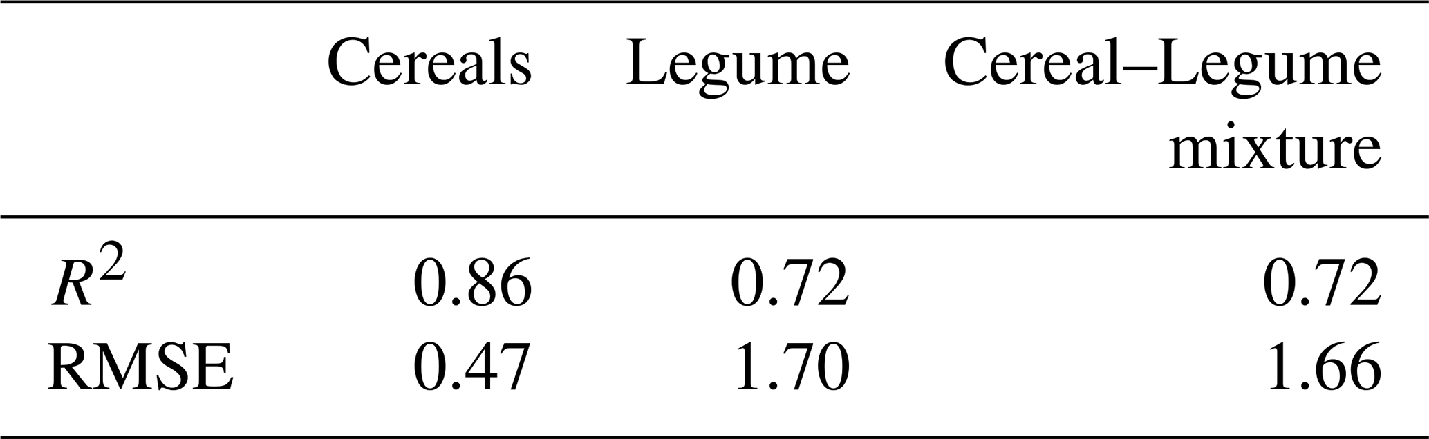
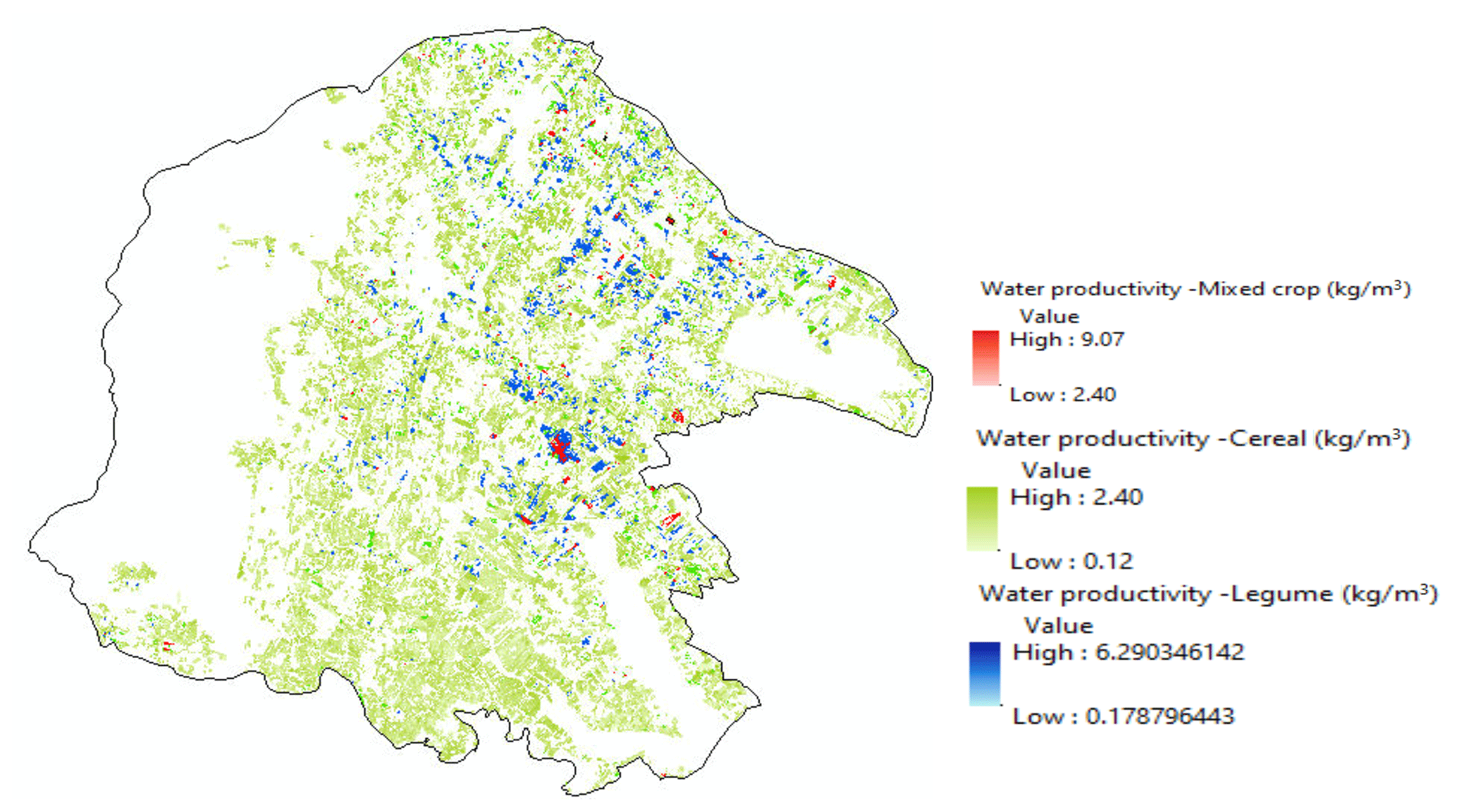
Under climate change conditions, optimizing water resources management in rainfed agricultural production systems requires the reasonable choice of crops. In this context, the adoption of crops diversification is promoted to increase the agricultural production and the added value per cubic meter of rain water (green water) used by crops. Contributing, therefore, to increase agricultural production and to preserve soil and water resources. The objective of this study is: (i) to identify mixed crops within agricultural fields and, (ii) to evaluate the biomass production and the water productivity in the Lebna watershed (Cap-Bon, Tunisia) using remote sensing and field measurements. The study area, covering 210 km2, is characterized by the predominant of cereals, legumes and fodder cropping systems. The experiments allowed the quantification of crop evapotranspiration and the observed biomass production at the agricultural field plots. The use of the sentinel images and the observations at different agricultural fields allowed to produce NDVI maps. The results first confirmed a good correlation between biomass production and NDVI values. The exponential relationships showed a values of R2 greater than 0.7. The use of sentinel images and GIS allowed to compute water productivity from field to watershed scale.  The results revealed a considerable spatial variation in water productivity values for different crops. Compared to a single crop, the cereal-legume mixture cropping improved the water productivity. The maximum value with 9.07 kg m−3 is observed for the mixture crops. The lowest value (0.12 to 2.40 kg m−3) was obtained for the cereal crop. These results help to recommend adaptation measures in agricultural production systems to climate change.

Keywords

Biomass production; Water productivity; Sentinel 2

1 Introduction
https://piahs.copernicus.org/articles/385/313/2024/piahs-385-313-2024-f01

Figure 1The Lebna watershed study area.

Rainfed agriculture is mostly the primary source of food in the world; contributing to about 60 % of the total crop production (UNESCO, 2009). In Tunisia, rainfed agriculture occupies between 92 % of the utilized agricultural area and contributes to about 65 % of agricultural production (FAO, 2022). However, rainfed agriculture face climate change pressure that is expected to impact the crop yield and thus affecting the availability of food and interfering in various environmental factors such as water production and use efficiency. Hence, there is a need to explore reasonable choice of cropping system that increases the crop yield, optimize water resources management while ensuring a decent income for farmers in rainfed agriculture. In this context, the adoption of crops diversification is promoted to increase the agricultural production and the added value per cubic meter of rain water (green water) used by crops. Contributing, therefore, to increase agricultural production and to preserve soil and water resources. The objective of this study are: (i) to identify mixed cropping system within agricultural fields and, (ii) to evaluate the biomass production and the water productivity in the Lebna watershed (Cap-Bon, Tunisia) using remote sensing and field measurements.

2 Materials and methods

2.1 Study site

The study area was the Lebna watershed (210 km2, 36°4336°53 N, 10°4010°58 E) located in the Nabeul Governorate (Fig. 1). The climate regime is at the boundary between subhumid and semiarid conditions (IAO, 2002). From downstream to upstream, the mean annual rainfall and the mean annual evapotranspiration (Penman- Monteith reference crop) range from 450 to 800 mm and from 1000 to 1500 mm, respectively (IAO, 2002; Zitouna-Chebbi et al., 2012). As described in Mekki et al. (2018a), agricultural systems are mainly based on rainfed mixed farming and livestock. Annual crop areas cover 67 % of the study area. Perennial crops (mainly olive trees) cover 8 % of the total area of the study area. Wheat is mainly rotated with legumes or spices to capture the benefits of nitrogen fixation (in the case of legumes) and/or to control pests or weeds. However, forage crops may sometimes replace legume or spice crops in biennial succession. Livestock husbandry includes cattle, sheep and goat breeding. Arable land (annual and perennial crops) accounts for 75 % of the study area, while natural and semi-natural areas account for one-fifth. The Lebna watershed is subject to soil erosion and subsequent reservoir siltation. Mekki et al. (2018b) have shown that evapotranspiration is the predominant factor influencing soil moisture dynamics in this area and that evapotranspiration differs significantly depending on the crops, cropping practices, soil properties and climatic conditions. Consequently, they assumed that it is possible to control the amount of green water and, in part, runoff and downstream water yield by adopting appropriate agricultural practices, including the spatiotemporal distribution of crops.

Table 1Dates for ground measurements and Sentinel 2 images acquisition. The sentinel 2 images, scenes are provided by https://sentinels.copernicus.eu/web/sentinel/missions/sentinel-2/data-products (last access: 25 May 2020).

Download Print Version | Download XLSX

2.2 Data collection and analysis

The field surveys have been held during 2019/2020 growing season. The use of the sentinel images (Table 1) and the observations at different agricultural fields allowed to produce land use and NDVI maps (Fig. 2). The required georeferenced data were acquired by using existing data and classifying sentinel images. Data on the crops present in the fields during the growing season were obtained through field observations that have been used to train the supervised classification of the sentinel images series. The observed fields were distributed among the existing types of crops (217 fields for wheat, forage crops, 292 fields for spices and legumes, 317 fields for fodder crops among them 41 mixed cropping fields where 17 fields with cereal-legume crops). Five agricultural fields were selected to monitor the aboveground biomass for three types of crops: cereals (oats, barely, wheat), legume (faba bean), cereal-legume mixture (vetch-triticale mixture). Measurements of the aboveground biomass started from early January to mid-March, with around ten days' time step as shown in the Table 1. The spectral data were derived from a time series of multispectral sentinel images (Table 1) from which we determined the Vegetation Index (NDVI) which is the normalized difference of the red and the near infrared bands. The data processing was carried out with R software, we used the random forest library (Liaw and Wiener, 2002) for the classification of Sentinel 2 images and QGIS software for water productivity mapping. The calibration sample consisted of a subset of the observed fields. Six images taken between the end of December to the end of May were used for the supervised classification. The average prediction rate was 86 %. Once the classification is set up, we determined the NDVI maps for the catchment and we established the biomass maps using the NDVI-biomass correlations.

https://piahs.copernicus.org/articles/385/313/2024/piahs-385-313-2024-f02

Figure 2The flowchart of the methodology.

Download

The water productivity (WP) estimates the value obtained from each unit volume of water used in the production of a given production (Luan et al., 2018). The WP can be assessed considering the crop production in terms of vegetation biomass and/or grain production. The green water (rainfall) productivity (GWP) can be defined, where only effective rain “REff” is consumed during the crop growth period (Luan et al., 2018). GWP (kg m−3) can be calculated at the watershed scale.

(1) GWPgreen kg m - 3 = Y / 10 × R Eff

Where Y is the total crop production and REff is the effective rainfall (R) representing the total precipitation infiltrated in the soil for crop production. According to the observed measurements we estimated a runoff coefficient of 20 % and calculated the (REff=R-0.2R). The factor 10 is used to convert effective rain water depths (REff) in millimeters into water volumes per land surface in m3 ha−1.

3 Results

The observed total fresh aboveground biomass between January 2020 and March 2020 for the different land use (cereals, legumes and mixture crops) shows variation within the watershed. The highest value was observed on mixture crops, happened in the end of March and reached a maximum of 34 t ha−1 in 2020. Figure 3a, b and c presents the correlation between the biomass production and the NDVI values for fababean, wheat and mixture crop respectively. The results show a good correlation between biomass production and NDVI values. The exponential relationships showed a values of R2 greater than 0.7 as shown in Table 2.

Figure 4 presents the spatial variation of the GWP values for the different crops within the Lebna watershed. The results revealed a considerable spatial variation in water productivity values for different crops. Compared to a single crop, the cereal-legume mixture cropping seems to improve the water productivity in terms of biomass production. The maximum GWP value with 9.07 kg m−3 is observed for the mixture crops. The lowest GWP (0.12 to 2.40 kg m−3) was obtained for the cereal crop.

https://piahs.copernicus.org/articles/385/313/2024/piahs-385-313-2024-f03

Figure 3Correlation between biomass production and NDVI values for: (a) fababean, (b) wheat, and (c) mixture crops.

Download

Table 2The statistical indicators (R2 and RMSE) of the correlation between the NDVI and the aboveground biomass.

Download Print Version | Download XLSX

https://piahs.copernicus.org/articles/385/313/2024/piahs-385-313-2024-f04

Figure 4Map of the green water productivity (GWP) for wheat, legume and mixed crops for 2020–2021 for Lebna watershed.

Figure 4 presents the spatial variation of the GWP values for the different crops within the Lebna watershed. The results revealed a considerable spatial variation in water productivity values for different crops. Compared to a single crop, the cereal-legume mixture cropping seems to improve the water productivity in terms of biomass production. The maximum GWP value with 9.07 kg m−3 is observed for the mixture crops. The lowest GWP (0.12 to 2.40 kg m−3) was obtained for the cereal crop.

The observed variation across the watershed could be ascribed to the soil properties, the crop management practices during the growing cycle and the crop rotation in relation to the available soil water to the crop use.

4 Conclusions

The green water (rainfall) productivity assessment in Lebna watershed along the 2019/2020 growing season was performed using Sentinel 2 satellite images and the aboveground observed biomass for the cereal-legume, mixture crops. The results first confirmed a good correlation between biomass production and NDVI values. Compared to a single crop, the cereal-legume mixture cropping improved the green water productivity. These results help to recommend measures to increase the adaptation of rainfed agricultural to climate change. Further studies may refine the quantification of local scale WP values. The results are currently to be validated using the high number of field observations and satellite images over several years and dates (three cropping cycles). Also, the measured crop evapotranspiration can be used instead of effective rainfall to calculate a more relevant GWP as shown in the equation above. Ongoing work coupling field experiments, remote sensing and agro-hydrological model aims to develop simulation and evaluate the agri-environmental impacts of the rainfed cereal-legume mixture cropping.

Code availability

The software code is randomForest (https://CRAN.R-project.org/doc/Rnews/, Liaw and Wiener, 2002).

Data availability

The underlying research data is currently not publicly available due to privacy. The sentinel 2 images, scenes are provided by https://sentinels.copernicus.eu/web/sentinel/missions/sentinel-2/data-products (Copernicus Open Access Hub, 2020).

Author contributions

Conceptualization, IM and RZC; investigation, MB and AB; methodology, IM, RZC; SB, MB and AB; writing–original draft, IM and RZC; review-editing, all authors; projects administration and funding acquisition, IM, RZC and FJ. All authors have read and agreed to the published version of the manuscript.

Competing interests

The contact author has declared that none of the authors has any competing interests.

Disclaimer

Publisher's note: Copernicus Publications remains neutral with regard to jurisdictional claims in published maps and institutional affiliations.

Special issue statement

This article is part of the special issue “IAHS2022 – Hydrological sciences in the Anthropocene: Past and future of open, inclusive, innovative, and society-interfacing approaches”. It is a result of the XIth Scientific Assembly of the International Association of Hydrological Sciences (IAHS 2022), Montpellier, France, 29 May–3 June 2022.

Acknowledgements

The fieldwork was performed within a memorandum of understanding between CRDA Nabeul and INRGREF. We gratefully acknowledge Imed Belouafi (CTV Haouaria), Tarek Ajmi, Rim Louati, Jihen Zrili (INRGREF) for participating in the fieldwork. The cooperation of the farmers in the Lebna region by providing access to their land is highly appreciated.

Financial support

This research was supported by the PRIMA ALTOS project (ANR-18-PRIM-0011-01) and by public funds received from the MESRS. This work was also supported by the H2020-MSCA-RISE-2018 ACCWA project and by funds received from MESRS, IRESA and IRD under the framework of LMI NAILA.

Review statement

This paper was edited by Christophe Cudennec and reviewed by two anonymous referees.

References

Copernicus Open Access Hub: Sentinel-2 archives, https://sentinels.copernicus.eu/web/sentinel/missions/sentinel-2/data-products, last access: 25 May 2020. 

FAO: L'agriculture pluviale face aux changements climatiques en Afrique du Nord – Impact et perspective avec l'agroécologie, Tunis, https://doi.org/10.4060/cc0014fr, 2022.  

IAO: Land resources of the Oued Lebna catchment (Tunisia), in: 20th Course Professional Master: Remote Sensing and Natural Resources Evaluation, Florence, Italie, Istituto Agronomico per l'Oltremare, p. 132, https://doi.org/10.13140/RG.2.2.10428.77449, 2020. 

Luan, X., Wu, P., Sun, S., Wang, Y., and Gao, X.: Quantitative study of the crop production water footprint using the SWAT model, Ecol. Indic., 89, 1–10, 2018. 

Mekki, I., Bailly, J. S., Jacob, F., Chebbi, H., Ajmi, T., Blanca, Y., Zairi, A., and Biarnès, A.: Impact of farmland fragmentation on rainfed crop allocation in Mediterranean landscapes: a case study of the Lebna watershed in cap bon, Tunisia, Land Use Policy, 75, 772–783, https://doi.org/10.1016/j.landusepol.2018.04.004, 2018a. 

Mekki, I., Zitouna-Chebbi, R., Jacob, F., Ben, Mechlia N., Prévot, L., Albergel, J., and Voltz, M.: Impact of land use on soil water content in a hilly rainfed agrosystem: a case study in the cap bon peninsula in Tunisia, AGROFOR Int. J., 3, 64–75, https://doi.org/10.7251/AGRENG1801064M, 2018b. 

Liaw, A. and Wiener, M.: Classification and Regression by randomForest, R News 2, 18–22, [code], https://CRAN.R-project.org/doc/Rnews/, 2002. 

UNESCO: United Nations World Water Development Report 3: Water in a Changing World, Paris, UNESCO, and London, Earthscan, ISBN 978-92-3-104095-5, 978-1-84407-840-0, 978-89-8225-791-9, 2009. 

Zitouna-Chebbi, R., Prévot, L., Jacob, F., Mougou, R., and Voltz, M.: Assessing the consistency of eddy covariance measurements under conditions of sloping topography within a hilly agricultural catchment, Agr. Forest Meteorol., 164, 123–135, 2012. 

Download
Short summary
Optimizing water resources management in rainfed agricultural production systems requires the reasonable choice of crops. The adoption of crops diversification is promoted to increase the agricultural production. The objective of this study is : (i) to identify mixed crops within agricultural fields and, (ii) to evaluate the biomass production and the water productivity in the Lebna watershed (Cap-Bon, Tunisia) using remote sensing and field measurements.