the Creative Commons Attribution 4.0 License.
the Creative Commons Attribution 4.0 License.
 | 18 Apr 2024
Impact of the storm Alex on water exchanges between the Roya River and its alluvial aquifer
Bernard Ladouche
Benoit Dewandel
Melissande Ibba
Vincent Bailly-Comte
Marie Genevier
The alluvial aquifer of the transnational Roya River watershed is an important water resource for drinking water supply. Through successive European projects, a monitoring network has been implemented over the alluvial plain to improve the understanding of the functioning of this aquifer. For instance, studies highlighted the predominant role of surface water in the recharge of the aquifer. Following the storm Alex and the resulting exceptional flood event in the Roya valley in October 2020, a general decrease of the piezometric levels was observed in the alluvial aquifer. Changes in the river morphology and in the granulometry of the hyporheic zone have impacted surface water – groundwater exchanges and reduced the aquifer recharge.
- Article
(2110 KB) - Full-text XML
- BibTeX
- EndNote


UPH12; Roya River; alluvial aquifer; aquifer recharge; storm Alex; Field observation
The alluvial aquifer of the transnational Roya River watershed is exploited for drinking water to supply both French and Italian coastal cities. In 2019, 36 Mm3 water have been withdrawn from the alluvial aquifer to provide water to 350 000 inhabitants of the French and Italian riviera. Almost a third of this volume (14 Mm3) comes from the Porra wellfield located in the upstream area of the Roya alluvial plain (Fig. 1).
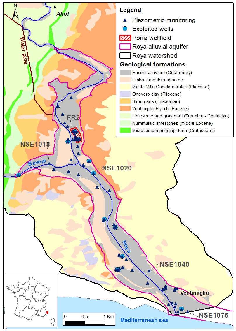
Figure 1Geology of the Roya alluvial plain and location of monitoring points.
The storm Alex, which passed through Europe in early October 2020, led to a high precipitation event in the Alpes-Maritimes county (South-East of France) on 3 October 2020. The meteorological stations recorded exceptional precipitation amounts reaching 663 mm in 24 h at the Mesches dam of Tende (Payrastre et al., 2022) and 284.1 mm at Breil-sur-Roya (Chochon et al., 2021). These precipitations caused flash floods in several valleys, notably those of the Vésubie, the Roya and the Tinée Rivers. The peak flow has been estimated to 1400 m3 s−1 (with an uncertainty that can reach ±50 %) for the Roya River at Breil-sur-Roya (Payrastre et al., 2022). The human and material damages were considerable. The storm also branded the landscapes with riverbeds moving. A less visible consequence of this event is the decrease of the piezometric levels in the alluvial aquifer, which began in the following days and induced operating difficulties in the Porra wellfield (Genevier et al., 2020).
The Roya transnational valley and its alluvial aquifer have been extensively studied since 2006 within successive Interreg European research projects (EUROBASSIN, RISKNAT, EUR-EAU-PA, CONCERT-EAUX). The last one focused on surface water – groundwater exchanges (Lanini and Wuillemier, 2020). Relying on the data collected and analysed within these projects, the present paper aims at describing the changes in the hydrosystem functionning caused by the storm Alex.
The Roya watershed covers 669 km2 from the upper part in the French Alps to the Italian Mediterranean coast. The downstream part of the catchment linked to the Roya reach globally comprised between the Italian cities of Trucco and Ventimiglia, includes a small elongate alluvial plain of 3.9 km2 (Fig. 1). At the Porra wellfield, the recent alluvium (sand with clay lenses) forms a 60 m thick layer resting on an impermeable bedrock composed of flysch.
The climate is Mediterranean in the alluvial plain, with mean annual precipitation of 791 mm yr−1 and mean annual temperature of 14.5 °C (from SAFRAN reanalysis data on the 2001–2019 period, Vidal et al., 2010).
The Roya River mean annual discharge is around 12 m3 s−1 at Airol, but around a quarter of it is diverted toward a powerplant and released in the Roya River just upstream the Porra wellfield (Fig. 1). Measurements of the flow along different profiles have shown the existence of flow losses in the Roya River between upstream and downstream. The Bevera River, which joins the Roya on the right bank downstream of Porra, also has significant losses.
The study of the alluvial aquifer is based on the monitoring of the groundwater level in a large number of piezometers (32) distributed on both sides of the Roya River (Fig. 1). In the Porra wellfield catchment, one observation well is equipped for monitoring temperature and electrical conductivity at seven different depths. Daily temperature data are also available from 2012 to 2018 in one of the pumping well, as well as punctual measures in a close piezometer and in the river. Two sampling campaigns of surface water and groundwater were conducted in low and high water context (respectively in October 2018 and May 2019) to perform chemical and isotopic analyses (δ18O, δ2H, 87Sr 86Sr, CFC SF6) in order to better understand the exchange between surface and groundwater (Ladouche et al., 2020).
A specific study of the aquifer recharge was also conducted (Lanini et al., 2020). The Water Table Fluctuation method (Healy and Cook, 2002) was applied to estimate the recharge of the aquifer using the daily data of six piezometers of the monitoring network that are not influenced by groundwater pumping. In parallel, the effective precipitation infiltration on the alluvial plain catchment has been evaluated thanks to several water budget methods using the ESPERE application (Lanini and Caballero, 2021). Comparing the results provided by the two approaches, the part of the aquifer recharge that is “seen” by the aquifer but does not come directly from the effective precipitation infiltration is estimated.
4.1 Before the storm Alex
In the observation well of the Porra wellfield, the vertical temperature profile established in February 2019 shows that the temperature is homogeneous over the entire depth of the permeable aquifer. The water temperature is quite distinct from that measured in the underlying aquitard layer (> 25 m depth) (Fig. 2). Temporal monitoring in the same observation well shows that seasonal temperature variations during the hydrological cycle are important (ΔT>8 °C) while the temperature is very stable in the underlying clayey layer (Fig. 3). Relying on the Roya water temperature estimated from the air data temperature, Ladouche et al. (2020) showed that the impulse response of the system which transforms the surface water temperature time series into the groundwater time series is characteristic of advective transfers. A shift comprised between 10 and 100 d is evaluated between the extrema of the surface water temperature curve and that of groundwater in different observations wells (Fig. 4). The CFCs and SF6 concentrations in groundwater confirmed that the aquifer is recharged with recent water. The chemical analysis and isotope study corroborated these interpretations of surface water – groundwater exchanges. It also highlighted the inputs of the Bevera River to the aquifer downstream the confluence, the Bevera water being characterized by high SO4 and Sr contents (Fig. 5).
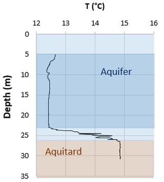
Figure 2Temperature vertical evolution in the FR2 observation well (12 February 2019 logging data).
The recharge study indicated that the aquifer recharge is comprised between 1400 and 1700 mm yr−1 and confirmed that the contribution of effective rainfall is low (it represents only 15 % to 20 % of the total recharge of the aquifer).
4.2 After the storm Alex
Following the storm Alex, piezometric measurements throughout the alluvial aquifer showed a continuous downward trend (Fig. 6, see piezometers location on Fig. 1). In order to avoid desaturation of the aquifer in the area of the wellfields, water authorities applied emergency measures as early as November 2020. Therefore, trenches were excavated along the riverbed to facilitate surface water infiltration. This produced rapid water level increases (Fig. 6). However, this impact was time-limited, and similar operations had to be done regularly (Genevier and Ibba, 2021).
It seems that the flood of the storm Alex has modified the preferential flow paths and main transfer patterns between the different reservoirs of the hydrosystem. As shown previously, before Alex, the aquifer temperature between 5 and 25 m depth exhibited an annual cycle directly related to the temperature of the Roya River water that infiltrates the aquifer. After the flood event, the groundwater temperature behaviour evolved in the transition zone. At 25 m depth, it seems to be also influenced by the temperature of the deeper layer (which remains stable, around 14 °C) with high frequency variations that are superimposed to the annual cycle (Fig. 3).
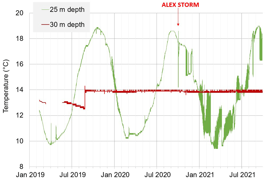
Figure 3Groundwater temperature evolution at two different depths (data from FR2 observation well in the Porra wellfield).
The observation point NSE1076 (depth 80 m, see location on Fig. 1) is located near the shoreline. It allows the monitoring of electrical conductivity of water at different depths in order to better understand the temporal evolution of marine intrusion. Measures show that the mineralization of the aquifer in the downstream zone has increased over the last 2 years (Fig. 7) due to the decrease of the hydraulic head in the aquifer.
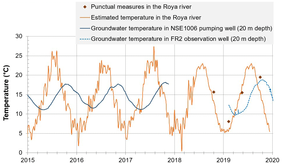
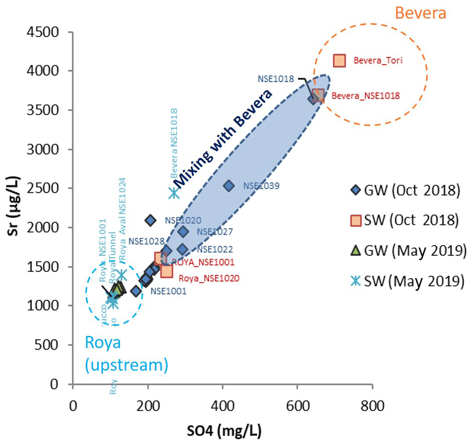
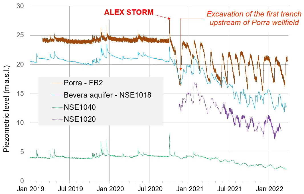
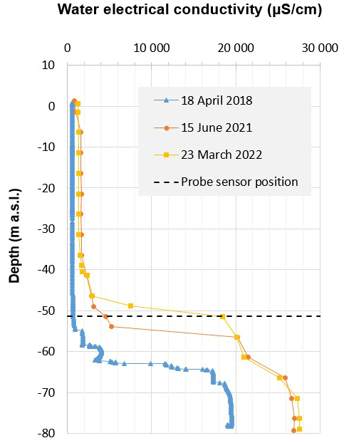
Figure 7Water electrical conductivity profiles in a 100 m-deep well located near the coast line.
The changes observed in the Roya alluvial aquifer functioning after the storm Alex may be linked to several combined mechanisms which altered the capacity of the aquifer recharge by the river.
Firstly, during and after the flood event, an important volume of sediment has been transported by the Roya River from the upper valley to the alluvial plain and the Mediterranean sea, as shown by the Sentinel satellite images (e.g. on https://geoimage.cnes.fr/fr/les-consequences-de-la-tempetes-alex-sur-le-pourtour-mediterraneen-octobre-2020, last access: 10 May 2023). This lead to the clogging of the riverbed by finest particles, which strongly reduced its infiltration capabilities.
In addition, the morphology of the river has been modified with significant movements of the riverbed. Consequently, the relationships between surface water and groundwater have been impacted as the preferential flowpaths have been redrawn.
The upper alluvial part of the riverbed was washed out to the sea by the flood, modifying the sediment granulometry in the hyporheic zone. This constitutes another perturbation for superficial groundwater flows.
Changes in rock-water chemical interactions leading to mineral precipitation, and thus possible riverbed clogging, were investigated but no evidences of these processes was found yet (Gal and Genevier, 2022).
Finally, the flood from the storm Alex deeply modified the hydraulic equilibrium of the river – exploited aquifer system. The aquifer recharge upstream the wellfield is not sufficient any more to balance the withdrawal for drinking supply. This shortage might also be enhanced by the stop of the powerplant and thus the stop of its focused water release to the river just upstream the wellfield.
A monitoring network has been implemented over the alluvial plain of the Roya River since many years to highlight the functioning of the aquifer. It allowed understanding the important role of surface water in the recharge of the hydrogeological reservoirs. It proved to be notably useful to characterize the changes induced by the storm Alex in October 2020. Nevertheless, further research works would be needed to explore the links between sediment transport and water levels decreases, or the possible chemical modifications of surface water and groundwater induced by the flood.
The data used in this study come from the Roya aquifer observatory, a numerical platform developed within the CONCERT-EAUX project which collects both French and Italian data from surface and groundwater monitoring networks. Data supporting the findings of this study are available upon request to the corresponding author.
MI, VBC and MG conducted the field investigation; SL, BL and BD analyzed the data; MG administrated the project; SL wrote the manuscript draft; SL, BL, BD, VBC and MG reviewed and edited the manuscript.
The contact author has declared that none of the authors has any competing interests.
Publisher's note: Copernicus Publications remains neutral with regard to jurisdictional claims in published maps and institutional affiliations.
This article is part of the special issue “IAHS2022 – Hydrological sciences in the Anthropocene: Variability and change across space, time, extremes, and interfaces”. It is a result of the XIth Scientific Assembly of the International Association of Hydrological Sciences (IAHS 2022), Montpellier, France, 29 May–3 June 2022.
This research work has been mainly conducted in the framework of the CONCERT-EAUX project (2017–2020, https://www.concert-eaux.eu, last access: 9 May 2023)
This research has been supported by the European Union (programme Interreg ALCOTRA), BRGM and the CARF intercommunal structure.
This paper was edited by Christophe Cudennec and reviewed by three anonymous referees.
Chochon, R., Martin, N., Lebourg, T., and Vidal, M.: Analysis of Extreme Precipitation During the Mediterranean Event Associated with the Alex Storm in The Alpes-Maritimes: Atmospheric Mechanisms and Resulting Rainfall, in: Advances in Hydroinformatics, edited by: Gourbesville, P. and Caignaert, G., Springer Water, Springer Nature, Singapore, 397–418, https://doi.org/10.1007/978-981-19-1600-7_26, 2022.
Gal, F. and Genevier, M.: Champ captant de Porra sur la nappe de la Roya – Interprétation des analyses chimiques disponibles, Rapport BRGM/RP-71789-FR., 2022.
Genevier, M. and Ibba, M.: Appui scientifique et technique sur la problématique de colmatage des alluvions de la Vallée de la Roya aux abords du captage de Porra (Vintimille, Italie), Rapport BRGM/RC-70730-FR, 2021.
Genevier, M., Ibba, M., and Norie, A.: Chute anormale du niveau de la nappe de la Roya au droit du champ captant de Porra et aux alentours, Rapport BRGM/RP-70354-FR, 2020.
Healy, R. W. and Cook, P. G.: Using groundwater levels to estimate recharge, Hydrogeol. J., 10, 91–109, https://doi.org/10.1007/s10040-001-0178-0, 2002.
Ladouche, B., Bailly-Conte, V., Rivet, F., and Genevier, M.: Projet Interreg ALCOTRA “ CONCERT-EAUX ”. Eléments d'analyses géochimiques, isotopiques et thermiques de la nappe alluviale de la Roya Rapport final, BRGM/RP-71899-FR, 43 pp., 2020.
Lanini, S. and Caballero, Y.: ESPERE, a Tool for Multimethod Aquifer Recharge Estimation: What's New with Version 2, Groundwater, 59, 5–6, https://doi.org/10.1111/gwat.13049, 2021.
Lanini, S. and Wuillemier, A.: Projet Interreg ALCOTRA “CONCERT-EAUX”. Synthèse hydrogéologique, étude de la recharge et modèle conceptuel de la plaine alluviale de la Roya, Rapport BRGM/RP-71900-FR, 68 pp., 2020.
Payrastre, O., Nicolle, P., Bonnifait, L., Brigode, P., Astagneau, P., Baise, A., Belleville, A., Bouamara, N., Bourgin, F., Breil, P., Brunet, P., Cerbelaud, A., Courapied, F., Devreux, L., Dreyfus, R., Gaume, E., Nomis, S., Poggio, J., Pons, F., Rabab, Y., and Sevrez, D.: Tempête Alex du 2 octobre 2020 dans les Alpes-Maritimes: une contribution de la communauté scientifique à l'estimation des débits de pointe des crues, LHB, 2082891, https://doi.org/10.1080/27678490.2022.2082891, 2022.
Vidal, J. P., Martin, E., Franchistéguy, L., Baillon, M., and Soubeyroux, J. M.: A 50-year high-resolution atmospheric reanalysis over France with the Safran system, Int. J. Climatol., 30, 1627–1644, 2010.