the Creative Commons Attribution 4.0 License.
the Creative Commons Attribution 4.0 License.
 | 18 Apr 2024
Flood impact assessment in urban settings with porous buildings – insights from a fine-scale hydraulic-economic model
David Nortes Martinez
Cécile Choley
Pascal Finaud-Guyot
Classical hydraulic approaches of urban floods consider buildings as obstructions to water flow, without considering the flow exchanges between streets and buildings. Since the hydraulic behavior within the building is not considered, there exists a gap on the available information regarding the fine characterization of material damage and human exposure within buildings. Because of this gap, damage estimation usually assumes that the floodwater depths inside and outside the buildings are the same. However, as flood damage functions are very elastic with respect to floodwater depth, especially in the lower values, relatively small differences in water depth can lead to large differences in the assessment of material damage. Not considering street-building flow exchanges might be introducing a bias in the estimation of property damage.
In this paper, we propose to analyse how fine-scale hydraulic and economic modelling approaches considering street-building flows can influence the characterization of material damage at a larger scale (district). To do so, we couple a hydraulic model with an economic model to simulate water depths and to estimate flood damage under: (i) a classical approach using non-porous buildings and (ii) an alternative approach explicitly considering street-building flow exchanges. The results obtained show rather notable differences in floodwater depth and economic damage at both building and district level.
- Article
(2971 KB) - Full-text XML
- BibTeX
- EndNote


UPH 21; SDG 11.B; SDG 11.5; modelling; flood; flood damage assessment; building; opening; vulnerability
Estimating the impacts of flooding in urban areas is of primary importance when qualifying the exposure of territories. One of the difficulties encountered is that the processes at stake involve fine scales (building scale).
Classical approaches in flood modeling in the urban environment integrate buildings as obstructions to the water flow (Schubert and Sanders, 2012). However, these approaches fail to simulate water flows inside buildings (Bellos and Tsakiris, 2015). By disregarding street-building water flow exchanges, classical approaches are not able to explain the potential role of buildings for water storage and the consequent potential effect on the reduction of the peak discharge (Gems et al., 2016). Furthermore, secondary connections between streets through buildings and fine simulation of floodwater depth within the building are out of the scope of classical modeling practices in urban flood modeling (Sturm et al., 2018). Despite those drawbacks, experiments considering water intrusion within buildings are seldom in the literature (Bellos and Tsakiris, 2015; Choley et al., 2021).
The absence of such fine simulations leads to the need for assumptions when estimating urban flood damage. For instance, considering buffers around building edges to estimate the floodwater depth inside from the depth outside. Such methods may lead to overestimations of flood damage because of the underlying hypotheses (e.g. independently of the building and severity of the event, the water fills the building and the same depth is reached everywhere). Hence, we argue that finer flood damage estimations of urban floods and the design of better emergency responses would benefit from more accurate simulations of the hydraulic behavior within buildings.
In our work, we propose a coupled hydraulic-damage model for the simulation of flood events and the estimation of material damage in porous urban environments. In this paper, we use this model to determine whether to consider openings in the hydraulic modeling influences the damage estimation at a district level.
Our method couples a hydraulic model with a damage model. The hydraulic model represents both the street water flows using classical 2D shallow water equations and the mass conservation in each building with a reservoir model assuming no velocity in average within the building. Street shallow water equations are discretized using a classical finite volume Godunov scheme based on 2D unstructured mesh. Street and building models are computed using an Euler explicit approach such as preserving the stability and the water depth positivity. Those models are implemented in the sw2d software (https://sw2d.inria.fr/, last access: 28 April 2023).
An opening is used to connect a cell and a building. It should be noted that each building can be connected to different cells of the mesh and conversely, a cell can be connected to several buildings. The opening discharge depends on the water level in the street and in the building allowing to represent a nil discharge if the same water level is reached on both side of an opening (see Choley et al., 2021, for more details).
To assess flood damage, we use two tools from the floodam tool set: floodam.building and floodam.spatial. The floodam tool set is a collection of libraries written in R language, developed within the French working group “GT AMC” which aims at developing methodologies for the economic appraisal of flood management policies (with the support of the French Ministry in charge of the Environment).
The floodam.building tool (Grelot and Richert, 2019; Grelot et al., 2022) produces flood damage functions for built assets, such as buildings or dwellings. To do so, the floodam.building tool counts on a library of elementary damage functions for each component of a building, for all possible combinations of flood duration and floodwater depth, established from expert knowledge. Thus, departing from an inventory of elementary components of a given building or dwelling – e.g. floors, ceilings, coatings, walls, etc. –, the floodam.building tool enables us to estimate the building's damage function as a combination of the damage functions of elementary components. In addition, floodam.building also implements the average national french damage functions (see Rouchon et al., 2018).
The floodam.spatial tool (Grelot and Richert, 2021) is intended for flood damage estimation from spatial data. The tool enables us to transform spatialized flood parameters, such as floodwater depth associated to a spatial point or polygon, into monetary estimates of the damage caused based on the assets involved.
The workflow to couple all these tools is displayed in Fig. 1: on the one hand, departing from information on the built area and on the event, the hydraulic model estimates the floodwater depth in the simulation perimeter considering either nonporous (i.e. no openings) and porous (i.e. with openings) buildings. The estimation of the floodwater depth in the interior of each building in the simulation perimeter depends on whether buildings are considered porous or nonporous. In the former case, the hydraulic model is able to calculate the floodwater depth inside each building, whereas in the latter case, the floodwater depth in the interior of the building should be estimated indirectly. To do so, we follow the following procedure: (i) identification of the building; (ii) identification of the grid cells adjacent to the building; (iii) calculation/estimation of the potential gap between the building's floor level and the street level; and (iv) estimation of the floodwater depth inside the buildings as the difference between the exterior floodwater level and the building's floor level.
The damage function issued from floodam.building, the estimates of floodwater depth within each building calculated from the hydraulic model and the duration of the flood are fed to floodam.spatial. Using floodam.spatial, we estimate the damage endured by each building in the simulation perimeter.

Figure 1Coupled model flowchart.
Our experimental design uses the 1988 flood event in Nîmes (southeastern France) as reference. This major event was originated by heavy rainfall upstream the city (420 mm in 8 h). It registered waters depths up to 3 m in the streets of the city. Around 45 000 people were impacted and the total damage rose to more than 600 millions of euros (Mignot et al., 2006; Fabre, 1989, 1990).
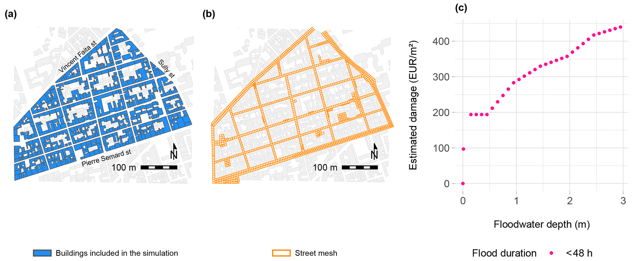
Figure 2Experimental design: (a) buildings considered in the simulation perimeter; (b) street mesh in the simulation perimeter; (c) average national French damage function for short flood events (less than 48 h).
The simulation perimeter (Fig. 2a and b) corresponds to the Richelieu district, delimited by the streets Vincent Faïta, Sully and Pierre Semard. This perimeter was severely affected during the 1988 flood event. The street layout is rather simple within the perimeter, with mostly 90° intersections. The average slope, oriented north to south, is higher than 1 % (Mignot et al., 2006; Choley et al., 2021).
The boundary conditions used in the modeling are as follows: Upstream, the discharge is injected either at the upstream end of streets Sully and Vincent Faïta or at the connection between the Vincent Faïta street and the ones coming from the North. At the peak of the flood, the total injected discharge is 176 m3 s−1 with up to 92 m3 s−1 in the Sully street and 47 m3 s−1 in the Faïta street. At the downstream end, the free surface elevations imposed at the limits corresponding to an outlet street vary in the range [0.46, 1.77] m (Mignot, 2005; Choley et al., 2021).
The perimeter includes 438 buildings; courtyards are not taken into account. The floor level of buildings can be higher, lower or at the same level of the street. The simulation lasts 55 000 s, and a uniform Strickler friction coefficient K=40 m s−1 is applied (Mignot, 2005).
We simulate two scenarios: (i) the baseline scenario, which integrates nonporous buildings as obstacles, not considering street-building flow exchanges; and (ii) the indoor scenario, which integrates porous buildings as reservoirs, considering street-building flow exchanges through openings.
There are two openings per facade adjacent to a street. The width of the openings is variable and related to the width of the facade. One of the openings is always located at the same level as the building floor, while the other is located at a fixed height above the street level. Thus, since the floor level of each building is located at a variable elevation from the street, the second opening of the pair is located at a variable height from the floor level of each building. Openings are considered fully open, i.e. obstacles to the street-building water flow, such as doors or windows, are not considered. The total number of the openings in a building depends on the number of facades adjacent to streets: a building with one facade adjacent to a street will have 2 openings, a building with 2 facades, 4 openings, etc.
To determine the economic damage to each building we use the average national French damage function for short flood events (less than 48 h), as displayed in Fig. 2c. It showcases a direct relationship between the monetary value of the flood damage and the floodwater depth: as the floodwater depth increases, the monetary value of damage increases. Notwithstanding, the elasticity damage-depth is variable: in the intervals (0, 0.15] and (2, 2.5] m the sensitivity of the monetary damage to changes in floodwater depth is more accentuated than in the intervals (0.15, 2] and (2.5, 3] m. Furthermore, in the interval (0, 0.15] m monetary damage is extremely sensitive to changes in floodwater depth.
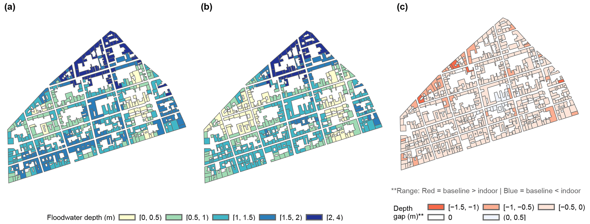
Figure 3Geographical distribution of estimates of floodwater depth associated to each building in the simulation perimeter: (a) baseline scenario; (b) indoor scenario; and (c) differences in floodwater depth between baseline and indoor scenarios.
4.1 Floodwater depth
Figure 3a and b display the maximum floodwater depth per building in the baseline and the indoor scenarios, respectively.
In the baseline scenario, 80 % of floodwater depths concentrate in the range [0, 1.75] m, with the most extreme simulated floodwater depths reaching 3.5 m. In the indoor scenario, the 80 % of the observations concentrates in the range [0, 1.5] m and the most extreme floodwater depth reaches 3.1 m. Comparing both scenarios (Fig. 3c), we observe that the baseline scenario overestimates the floodwater depth in 95 % of the buildings in comparison with the indoor scenario. In terms of magnitude, the depth gap between the two scenarios concentrates in the interval [−0.5, 0.5] m for 92 % of the buildings, while the remaining 8 % fall in the interval [−1.5, −0.5) m.
4.2 Economic damage
Table 1Estimated monetary damage per scenario in the simulation perimeter.

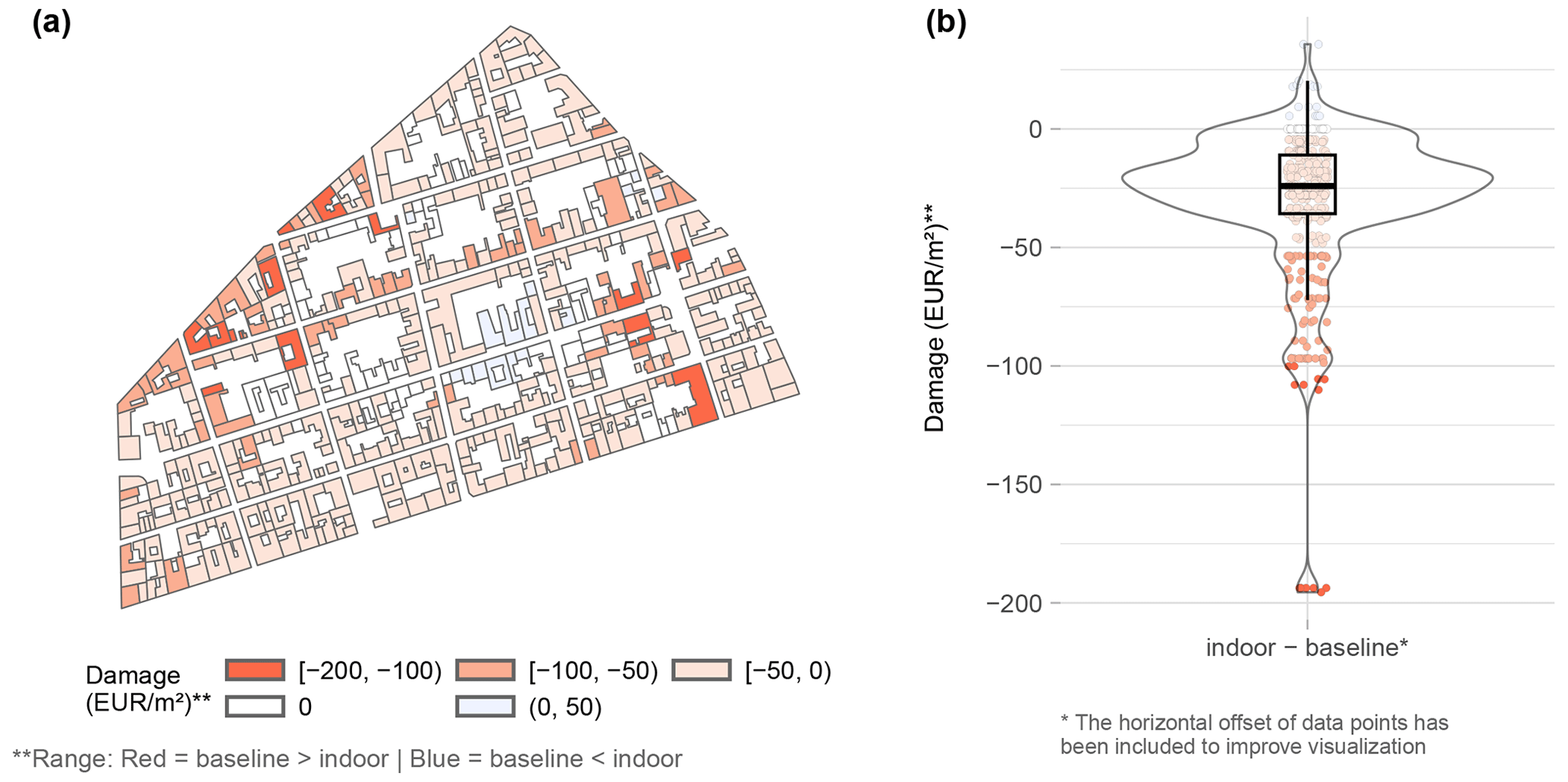
Figure 4Differences in the estimates of damage per squared meter in the simulation perimeter between the baseline scenario and the indoor scenario: (a) geographical distribution; and (b) density-boxplot.
Table 1 shows the monetary estimation of flood damage for the ensemble of the simulation perimeter, calculated according our two scenarios, baseline and indoor. The estimated flood damage in the baseline and in the indoor scenarios are 15.3 and 13.7 millions of euros, respectively. In other words, not considering street-building exchanges leads us to overestimate the damage caused by the flood event by 10 %.
Figure 4 shows a comparison of monetary damage per squared meter estimated with the baseline and indoor scenarios. Although both scenarios present the same range of monetary damage (between EUR 0 and 439 per m2), 90 % of the buildings display differences between the indoor and the baseline scenarios. Indeed, the baseline scenario overestimates the monetary damage in 86 % of the buildings, underestimates the monetary damage in 4 % of the buildings and remains the same as the indoor scenario in the remaining 10 %. The interval EUR [−50, 50] per m2 accounts for 84 % of the buildings. In terms of spatial distribution (Fig. 4a), the differences in economic damage follow, although not systematically, a pattern similar to the differences in floodwater depth from Fig. 3c.
In our simulation perimeter, almost all buildings show differences in floodwater depth between the baseline and the indoor scenarios (only one building remains unchanged). In the case of estimated monetary damage, 90 % of the buildings differ between the scenarios. Thus, at individual building level, differences between scenarios are notable. Looking at the ensemble, not considering street-building exchanges leads to an overestimation of damage at district level, although the magnitude of the overestimation relative to the magnitude of the total damage is rather small.
These results are nonetheless coherent with the type of indoor scenario simulated. When considered, openings are set as fully open, thus water does not found any obstacle to fill the building. In these conditions, minimal differences between the baseline scenario and the indoor scenario are to be expected.
More in-depth studies conducted at building level, considering both the building layout and the state of the openings, show that significant differences in the damage level exist when openings are close though not waterproof (Nortes Martinez et al., 2022). Consequently, the ongoing work focuses, on the one hand, on adapting the model to consider alternative opening states, and, on the other hand, on carrying out complementary analyses at higher levels of resolution, considering the influence of the hydraulic behavior inside the buildings not only in the estimation of monetary damages but also in terms of danger.
The hydraulic model as well as the models floodam.building and floodam.spatial are available upon request.
The French National damage functions are available at https://www.ecologie.gouv.fr/levaluation-economique-des-projets-gestion-des-risques-naturels (Ministère de la Transition écologique et de la Cohésion des territoires, 2023). The data generated by the simulation models are part of an ongoing research project and are therefore not yet publicly available. Please contact the authors to inquire about availability.
CC and PFG developed the hydraulic models and calculate the physical flood parameters. FG developed the damage model. DNM coupled both models and performed the floodwater depth and damage analysis. DNM and FG wrote the first draft of the article. All authors discussed and edited the paper.
The contact author has declared that none of the authors has any competing interests.
Publisher's note: Copernicus Publications remains neutral with regard to jurisdictional claims in published maps and institutional affiliations.
This article is part of the special issue “IAHS2022 – Hydrological sciences in the Anthropocene: Variability and change across space, time, extremes, and interfaces”. It is a result of the XIth Scientific Assembly of the International Association of Hydrological Sciences (IAHS 2022), Montpellier, France, 29 May–3 June 2022.
The authors acknowledge the financial support offered by the French Ministry of the Environment and the French National Research Agency (ANR). David Nortes Martínez received a postdoctoral fellowship from the French National Research Institute for Agriculture, Food and the Environment (INRAE). Cécile Choley received a doctoral fellowship from the French National School for Water and Environmental Engineering (ENGEES).
This research has been supported by the French National Research Agency (ANR) for the project DEUFI (DEtailing Urban Flood Impact) (grant no. ANR-18-CE01-0020) and the French Ministry of the Environment (INRAE-DGPR agreement no. 2103343215).
This paper was edited by Christophe Cudennec and reviewed by two anonymous referees.
Bellos, V. and Tsakiris, G.: Comparing Various Methods of Building Representation for 2D Flood Modelling In Built-Up Areas, Water Resour. Manage., 29, 379–397, https://doi.org/10.1007/s11269-014-0702-3, 2015. a, b
Choley, C., Finaud-Guyot, P., Garambois, P.-A., and Mosé, R.: An Effective Urban Flood Model Accounting for Street-Building Exchanges, in: Simhydro 2021, 6th International Conference Models for complex and global water issues – Practices and expectations, 16–18 June 2021, Sophia Antipolis, France, https://hal.archives-ouvertes.fr/hal-03520964 (last access: 28 April 2023), 2021. a, b, c, d
Fabre, G.: Les inondations catastrophiques de Nîmes et de sa région du lundi 3 octobre 1988/The catastrophic floods of Nîmes and its area on 3rd October 1988, Géocarrefour, 64, 224–230, https://doi.org/10.3406/geoca.1989.5696, 1989. a
Fabre, G.: La catastrophe hydrologique éclair de Nîmes (3 octobre 1988) (The flash flood disaster at Nîmes on 3 octobre 1988), Bulletin de l'Association de Géographes Français, 67, 113–122, https://doi.org/10.3406/bagf.1990.1522, 1990. a
Gems, B., Mazzorana, B., Hofer, T., Sturm, M., Gabl, R., and Aufleger, M.: 3-D hydrodynamic modelling of flood impacts on a building and indoor flooding processes, Nat. Hazards Earth Syst. Sci., 16, 1351–1368, https://doi.org/10.5194/nhess-16-1351-2016, 2016. a
Grelot, F. and Richert, C.: Modelling Flood Damage functions of buildings. Manual for floodam v1.0.0, Research report, IRSTEA, https://hal.inrae.fr/hal-02609309 (last access: 28 April 2023), 2019. a
Grelot, F. and Richert, C.: floodam.spatial: Estimation of flood damage in a given territory, http://www.floodam.org/ (last access: 28 April 2023), r package version 0.9.0 [code], 2021. a
Grelot, F., Gontrand, F., Richert, C., Boisgontier, H., and Nortes Martinez, D.: floodam.building: Creation of flood damage functions for buildings, http://www.floodam.org/ (last access: 28 April 2023), r package version 1.0.0.2 [code], 2022. a
Mignot, E.: Etude expérimentale et numérique de l'inondation d'une zone urbanisée : cas des écoulements dans les carrefours en croix, Theses, Thèse en Mécanique, Ecole centrale de Lyon, https://hal.inrae.fr/tel-02586882 (last access: 28 April 2023), 2005. a, b
Mignot, E., Paquier, A., and Haider, S.: Modeling floods in a dense urban area using 2D shallow water equations, J. Hydrol., 327, 186–199, https://doi.org/10.1016/j.jhydrol.2005.11.026, 2006. a, b
Ministère de la Transition écologique et de la Cohésion des territoires: L'évaluation économique des projets de gestion des risques naturels, Gouvernement de France [data set], https://www.ecologie.gouv.fr/levaluation-economique-des-projets-gestion-des-risques-naturels (last access: 28 April 2023), 14 March 2023. a
Nortes Martinez, D., Grelot, F., Choley, C., and Finaud-Guyot, P.: Flood impact assessment in urban context: Coupling hydraulic and economic models for a fine scale damage assessment, EGU General Assembly 2022, Vienna, Austria, 23–27 May 2022, EGU22-3984, https://doi.org/10.5194/egusphere-egu22-3984, 2022. a
Rouchon, D., Christin, N., Peinturier, C., and Nicklaus, D.: Analyse multicritères des projets de prévention des inondations, Guide méthodologique 2018, Théma – balises, Paris, France, 2018. a
Schubert, J. E. and Sanders, B. F.: Building treatments for urban flood inundation models and implications for predictive skill and modeling efficiency, Adv. Water Resour., 41, 49–64, https://doi.org/10.1016/j.advwatres.2012.02.012, 2012. a
Sturm, M., Gems, B., Keller, F., Mazzorana, B., Fuchs, S., Papathoma-Köhle, M., and Aufleger, M.: Experimental analyses of impact forces on buildings exposed to fluvial hazards, J. Hydrol., 565, 1–13, https://doi.org/10.1016/j.jhydrol.2018.07.070, 2018. a