the Creative Commons Attribution 4.0 License.
the Creative Commons Attribution 4.0 License.
 | 18 Apr 2024
Isotope study of monthly rainfall and its response in the Santos Formation phreatic aquifer, Mesa de Los Santos, Santander (Colombia)
Maria Alejandra Cetina
Jean-Denis Taupin
Sully Gómez
Nicolas Patris
Mesa de Los Santos is an elevated plateau located in the Eastern Cordillera of Colombia (Andean region) in the Department of Santander (altimetric variation 300 to 1800 m a.s.l.). The region is marked by a shortage of potable surface water. The isotopic study of the rain and its relation to Los Santos Formation phreatic and fractured aquifer was carried out. Four rain stations were installed on top of the plateau (1275 to 1684 m a.s.l.) to collect monthly rainwater samples for stable isotopes. The rainwater stations recorded 1469 to 764 mm from North to South, and the seasonal patterns of stable isotopes were similar in all stations. The preliminary Local Meteoric Water Line is δ2H = 8.22×δ18O + 13.9, slightly above the GMWL with an intercept of +13.9 ‰, possibly indicating continental vapor recycling. The rain-weighted annual isotope means showed more depleted values in the southmost rain station (δ18O = −8.99 ‰, 1275 m a.s.l.). From the phreatic and fractured aquifer, 35 groundwater points were monitored bimonthly for stable isotopes (n=134) and three trends were differentiated in the isotopic content value of δ18O. Large temporal variability characterized 10 groundwater points (amplitudes greater than 1 ‰ in δ18O for each point) consistently with the seasonal behaviour of the rain, indicating flows with rapid transit on a monthly scale. 21 groundwater points showed a low temporal variability with year-round differences under 1 ‰ and presenting a spatial distribution of δ18O with enriched values towards the north (between −6.71 ‰ and −6.00 ‰) and depleted values towards the south (−8.97 ‰ to −8.14 ‰), which tends to be also consistent with the rainwater isotope distribution observed. The stability of year-round groundwater isotopic values is a sign of efficient mixing of groundwater and a slower transit. Finally, 4 groundwater points presented signs of evaporation, showing d-excess values between −6.4 ‰ and +4.3 ‰, in connection with surface water bodies that undergo evaporation before infiltration.
- Article
(3000 KB) - Full-text XML
- BibTeX
- EndNote


Rainwater; sedimentary groundwater; spatial and temporal isotope variability; Colombian Andes
Deuterium and Oxygen-18, stable isotopes of water, are broadly distributed throughout the terrestrial system and are commonly used as conservative tracers (Clark and Fritz, 1997). The isotopic fractionation of Deuterium and Oxygen-18 in rainfall, resulting from factors such as temperature, mass or continentality effect, latitude and altitude, can be used to determine the connection between groundwater and its recharge zone, the prevailing climatic conditions during infiltration, the dynamics of the water cycle, etc. (Blavoux and Letolle, 1995; Gonfiantini et al., 2001; Binet et al., 2017; Saranya et al., 2020).
Mesa de Los Santos is an elevated plateau located in the Eastern Cordillera (Andean region, Fig. 1a) of Colombia in the Department of Santander (Fig. 1a). The study zone covers an area of 430 km2, has a population of approximately 18 850 inhabitants CNPV, 2018; CNA, 2014), and features a semi-arid temperate to cold-dry climate, with a temperature difference of 10 °C between the bottom (28 °C) and top areas (18 °C) (Ingeoexploraciones-CAS, 2016). The rainfall regime is bimodal, with two low-rain seasons (December–February and June to August) and two rainy seasons (April–May and September to November), the mean annual rainfall is 1145 mm yr−1 (calculated over a period of 20 years, from 1995 to 2014), highlighting a critical situation in the southwestern zone with a decrease to 863 mm yr−1, and the actual evapotranspiration is 815 mm yr−1 (Becerra and Parra, 2016).
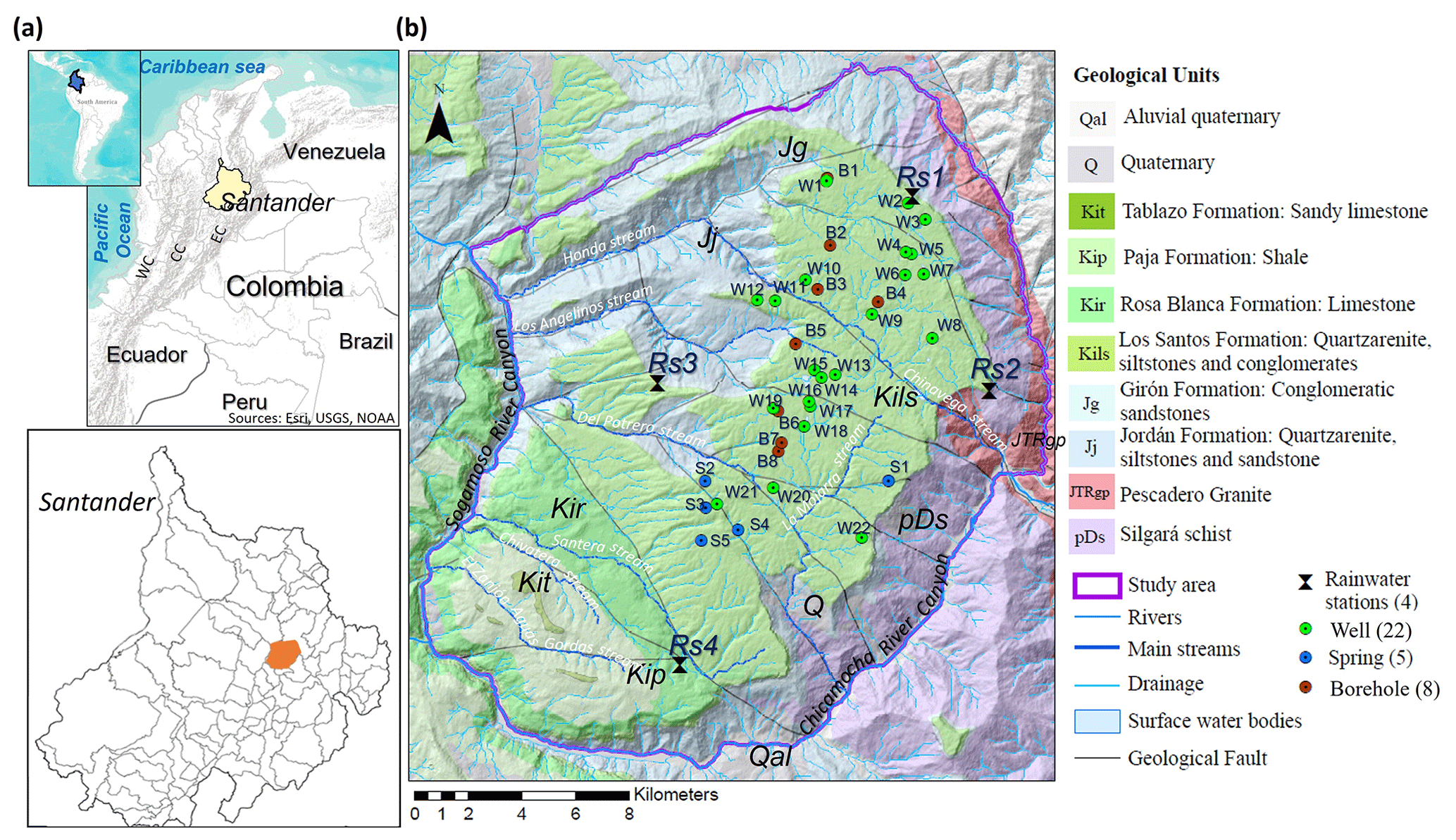
Figure 1(a) Study area location (highlighted in orange), EC: Eastern Cordillera, CC: Central Cordillera, WC: Western Cordillera. (b) geological map (Ingeominas-UIS,2007), rainwater stations, and groundwaters point location.
Historically, this region has been suffering from shortage of potable surface water (mainly in the southwestern) (FUNDEMESA, 2009). The hydrographic network is made up of the tributaries of Sogamoso (Honda, Los Angelinos, Del Potrero, Santera, Chivatera and El Zanjón Aguas Gordas streams) and Chicamocha (Chinavega and La Mojarra streams) rivers (Alcaldia Los Santos, 2003; Fig. 1b). The region is geographically isolated resulting from its elevated plateau landform nature, which restricts the surface water resources to only the contribution of rainfall that occurs in the area. During the dry seasons, (from 1 to 4 months without rain), the supply of surface water is limited, resulting in shortages. Considering this setting, groundwater is one of the main resources of water supply for the population.
Geologically, in the Mesa de Los Santos emerge Paleozoic metamorphic rocks of the Silgará Formation (schists), Jurassic igneous rocks Granito de Pescadero unit (granites), Jurassic sedimentary rocks Jordán (quartzarenite, siltstones and sandstone) and Girón (conglomeratic sandstones) formations and Lower Cretaceous sedimentary rocks Los Santos (quartzarenite, siltstones and conglomerates), Rosa Blanca (limestone), Paja (shale) and Tablazo (Sandy limestone) formations (Ingeominas-UIS, 2007, Fig. 1b). Metamorphic, igneous and Jurassic sedimentary rocks emerge on the moderately to steeply sloping hillsides and escarpments of the plateau boundaries. The Lower Cretaceous sedimentary sequence forms the top of the plateau where most of the people live. Los Santos Formation is the geological unit with the greatest area exposure at the top of the Mesa and is divided into three members: the Lower Member (conglomerates and quartz sandstones) with 56 to 152 m thickness, the Middle Member (siltstones, claystones and sandstones) with a thickness of 22 to 41 m, and the Upper Member (quartzarenites well cemented), 33 to 54 m thick (Ingeominas-UIS, 2007). The Upper Member of the Los Santos Formation presents the greatest hydrogeological potential of the study area and configures a phreatic and fractured aquifer (Ingeominas-UIS, 2007; Díaz et al., 2009). The aim of the present study is analyzing the isotopic composition of rainfall in the Mesa de Los Santos area and the isotope response of groundwater flows in the phreatic and fractured aquifer of the Los Santos Formation Upper Member sandstones, to contribute to the knowledge of groundwater circulation and provide tools for water resource management.
The present study is based mainly on rain and groundwater isotopic data acquired during 2020–2021 with complementary chemical data and Tritium to refine the interpretation of flow circulation. On the plateau, 4 rainwater stations (Rs) were installed on the plateau top (Fig. 1b) to collect monthly rainwater samples for stable isotopes (n=45) from September 2020 to August 2021. From the phreatic aquifer, 35 groundwater points (22 wells, 8 boreholes, and 5 springs) were monitored to measure water level, electrical conductivity, and stable isotopes (n=134, Fig. 1b, Table 2) in the months of December 2020, February, April, June, and August 2021. The tritium units (TU) were measured (n=20) in December 2020 and the major ion concentrations were analyzed (n=30) in October 2021. The isotopic analyses were carried out at the LAMA Stable Isotope Laboratory of HydroSciences Montpellier in France, using an ISOPRIME isotope ratio mass spectrometer (IRMS) with an analytical error of ±0.8 ‰ for δ2H and ±0.05 ‰ for δ18O; values are expressed in ‰ vs. VSMOW. Tritium was measured at the LHA-Avignon (analytical error 0.2–0.6 TU). The major ions were determined at the Industrial Consulting Chemical Laboratory of the Santander Industrial University (UIS).
Table 1Isotopic compositions (δ18O and δ2H) of rainwater stations.
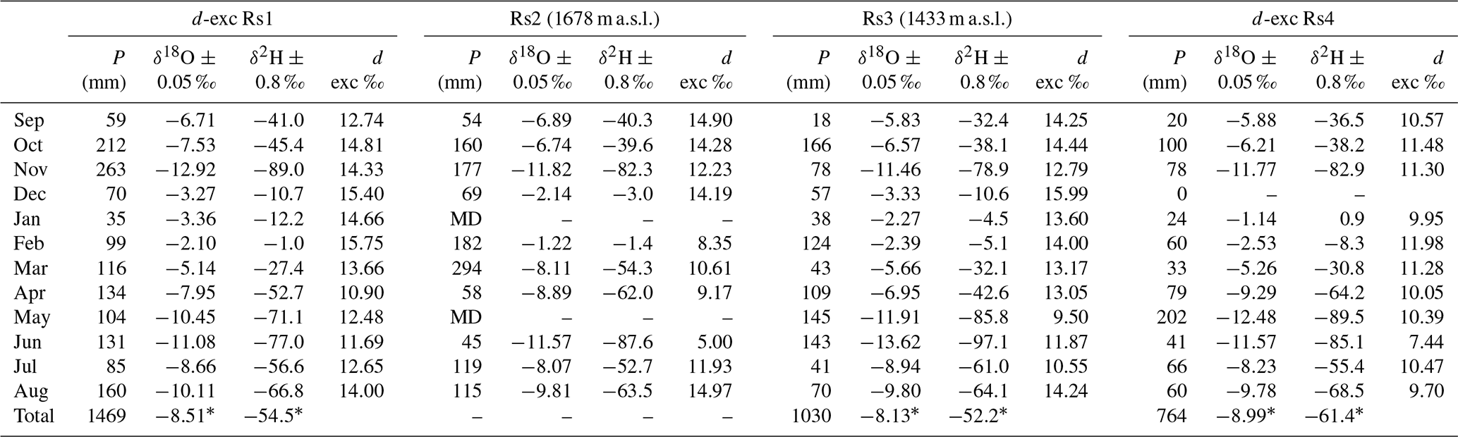
Rs = Rainwater station, P = Precipitation, MD = Missing data, ∗ Rain-weighted annual average isotopes values, m a.s.l. = meters above sea level.
Table 2Groundwater characteristics and isotopic compositions (δ18O and δ2H).
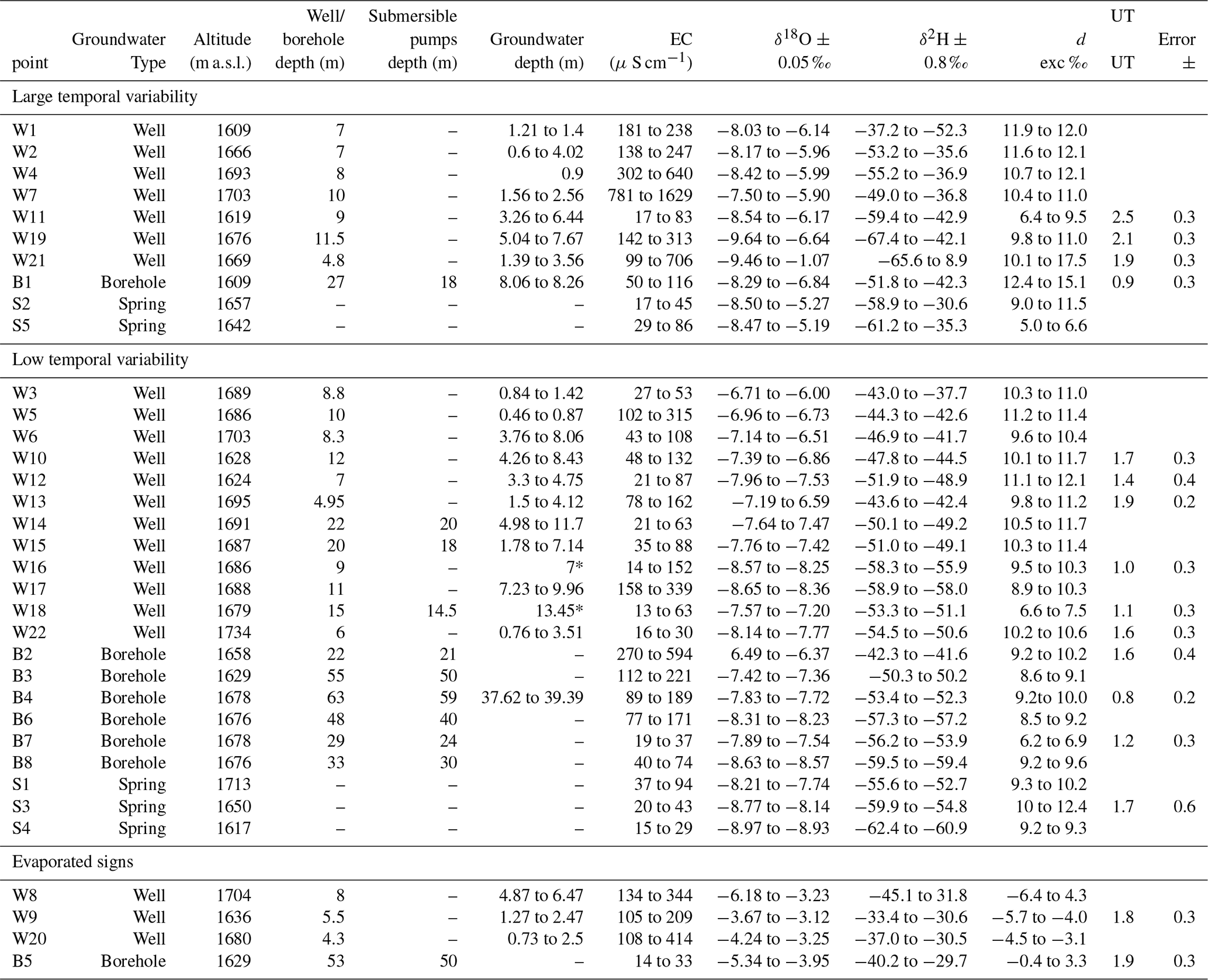
EC = electrical conductivity, m a.s.l. = meters above sea level, ∗ Dinamic level (afected by pumping).
3.1 Rainwater isotopic composition
The monthly isotopic composition of rainwater (δ18O and δ2H), the monthly precipitation amounts and the rain-weighted annual average isotopic values in each station are shown in Table 1. The seasonal behaviour of δ18O and δ2H is similar in the four stations and is rather consistent with the precipitation amount effect which is predominant in the tropical zone (Clark and Fritz, 1997), with a moderate correlation of R2: Rs1 = 0.41; Rs2 = 0.36; Rs3 = 0.14; and Rs4 = 0.38. The preliminary Local Meteoric Water Line (LMWL) calculated for the 12 months of isotope rainfall monitoring is δ2H = 8.22×δ18O + 13.9 (Fig. 2), which presents a similar slope than the Global Meteoric Water Line (GMWL, δ2HO+10) (Craig, 1961), the LMWL determined in Santander Massif (Gómez et al., 2015, δ2H = 8.15 × δ18O + 12.81), and the most of the LMWL determined in the Central Andes (Valdivielso et al., 2020). The LMWL show a greater deuterium excess compared to the GMWL (Craig, 1961; Rozanski et al., 1993), possibly indicating continental vapor recycling process (e.g., Gallaire et al., 2010). Gómez et al. (2015) determined an altitudinal δ18O gradient of −0.16 ‰ per 100 m in the Santander Massif. In our case no correlation was found with elevation, probably due to the low elevation range (ΔAltitude = 408 m). However, the values shown an isotopic composition more depleted in lowest one in elevation toward the south (Rs4).
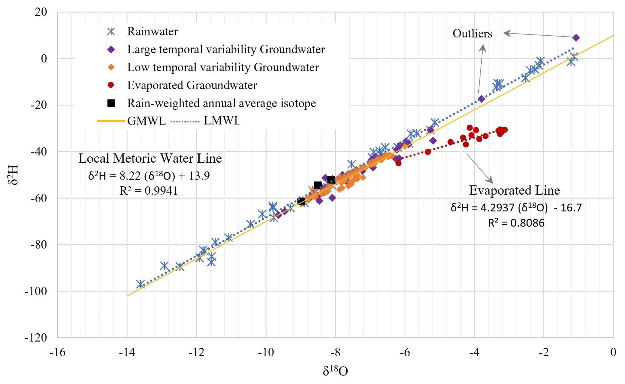
Figure 2Global meteoric water line (GMWL), local meteoric water line (LMWL), rain, groundwater, and rain-weighted annual average isotopic values.
The upper limit of the range of d-excess values in each rain station (Rs1: +10.9 to +15.8; Rs2: +5.0 to +15.0; Rs3: +9.5 to +16.0; Rs4: +7.4 to +12.0) showed values probably affected by continental vapor recycling process. A few monthly samples (d excess under +8 ‰) showed signs of evaporation, concerning months with lower rain amounts. In almost every month (except April 2021) a marked difference is observed in the deuterium excess values of the southern station (Rs4) which are generally lower than the other stations, which could indicate two moisture mass trajectories present in the area, possibly one from Santander Massif originated from the north and the second from canyons of the Chicamocha and Sogamoso rivers. The previous hypothesis could also explain the differences in the fractionation process of the stable isotopes (δ18O) between north and south zone.
3.2 Groundwater isotopic composition
The Upper Member of the Los Santos Formation is proposed as a phreatic and fractured aquifer. Despite the lithology composed of quartzarenites-type sedimentary rocks, the high content of siliceous cement reduces the primary porosity and allows to define a circulation through fractures (Díaz et al., 2009). Further, the top of the plateau presents an undulating geomorphology, which may control the directions of the groundwater and configuring disconnected reservoirs. Although the systems are complex the isotopic composition allowed to define preliminary groundwater behaviors. Three behaviors in the isotopic composition of δ18O (V-SMOW) can be identified: Large temporal variability, Low temporal variability, and evaporation marks (Table 2, Fig. 2). These behaviours can be observed throughout the entire study area (with no discernible spatial relationship).
For 10 groundwater points: 7 wells (W1, W2, W4, W7, W11, W19 and W21), 1 borehole (B1), and 2 springs (S2, S5) (Table 2), a relatively large temporal isotope variability prevails showing amplitudes greater than 1 ‰ in δ18O. The wells and the borehole show a shallow water level less than 10 m deep (water table averages between 1.4 and 5.1 m). The δ18O signal amplitude over the year varies between 1.67 ‰ (W7) and 8.39 ‰ (W21), this last point also showing the most enriched non-evaporated δ18O values (−1.07 ‰ and −3.80 ‰). The high temporal variability observed is consistent with the isotopic monthly behaviour of the rain. The TU values show a high activity in 3 samples (W11 = 2.5 TU, W19 = 2.1 TU, and W21 = 1.9 TU) supporting a rapid transit process with young water (Table 2). This implies a rapid infiltration possibly occurring through the fractures network, and water levels close to the surface possibly limiting the mixing in the unsaturated zone. The electrical conductivity data show three types of groundwater mineralization: low (17 to 86 µS cm−1), medium (99 to 344 µS cm−1) and high (640 to 1629 µS cm−1). The first and second modes are consistent with the lithology (quartzarenites) that implies low to moderate mineralization, while the third seems linked possibly to a contamination with anomalies in Cl−, SO, Na+, and K+.
Twenty-one groundwater points show a low temporal variability (differences less than 1 ‰ over the year): 12 wells (W3, W5, W6, W10, W12, W13, W14, W15, W16, W17, W18 and W22), 6 boreholes (B2, B3, B4, B6, B7 and B8), and 3 springs (S1, S3, S4). The wells water levels average between 2.2 and 7.1 m, with extremes values of 11.7 and 0.46 m. There is no information about the static level of all boreholes (because they have sealed borehead, except B4), but the depth of the submersible pumps evidence samples taken between 21 and 59 m from the surface. The amplitudes of δ18O time series vary between 0.06 (B8) and 0.71 ‰ (W3), indicating an efficient mixing of the groundwater. Spatially, this set of values present a distribution of δ18O with enriched values towards the north (between −6.71 ‰ and −6.00 ‰) and depleted values towards the south (−8.97 ‰ to −8.14 ‰), which tends to be also consistent with the rain isotope distribution also marked with depleted values towards the south. The TU values show activities less than 2.0 TU, with two samples close to 1.0 TU (W16 = 1.0 TU, and B4 = 0.8 TU) confirming an older water component with respect to the first group (Table 2) implying a slower transit, with deeper water levels and longer residence times. The electrical conductivity shows low (13 to 89 µS cm−1) to medium (94 to 339 µS cm−1) groundwater mineralization depending on lithology with no evidence of contamination, except for the point W5 where the moderate electrical conductivity (281 µS cm−1) is related to positive anomalies for Cl−, and Na+ and K+, implying a local contamination problem related to a very shallow phreatic level (less than 1 m).
The last 4 groundwater points present signs of evaporation (Fig. 2): 3 wells (W8, W9 and W20) and 1 borehole (B5) which show a shallow water level, with δ18O values between −6.2 ‰ and −3.1 ‰, d-excess values between −6.4 ‰ and +4.3 ‰. These points (Fig. 2) are situated on a local evaporation line: δ2H = 4.29 × δ18O-16.7. The 3 wells are close (distance less than 5 m) to small surface water bodies and present a continuous pumping favouring the drainage of surface water which is submitted to evaporation before infiltration. The borehole is located inside an upper sub-basin, near a small water body, and also subjected to frequent pumping.
The isotopic composition of rainwater in the Mesa de Los Santos area shows a geographic distribution with more depleted values towards the south of the area, suggesting possibly two different moisture pathways to the plateau (the Santander Massif and the canyons Sogamoso and Chicamocha Rivers). The isotopic signatures of rainwater and groundwater allow us to recognize the rapid response of the underground system in the phreatic Upper Member of the Los Santos Formation due to the fractures network controlling the percolation and circulation. The groundwater points with large temporal isotopic variability suggest a flow with rapid transit occurring at the monthly scale with a water table near the surface. The groundwater points with variability stable isotopic signature consistent with the rain isotopic distribution, indicate a good mix of water within the aquifer, with slower flow transit and groundwater circulations deeper than the previous behaviour. Finally, the isotopic behaviour of a number of points evidenced the mixing of evaporated surface waters into the ground, promoted by active pumping.
The map used in this paper was created using Esri's ArcMap software, which was licensed through Universidad Industrial de Santander. The software was used to create a geospatial representation of the data collected for the study. The underlying code of the ArcMap software is not publicly accessible.
Tables 1 and 2 presented in this study, display a subset of the data analyzed. The complete dataset is currently unavailable as it forms part of the ongoing doctoral thesis study of the primary author.
MC, SG and JT planned the campaign; MC performed the measurements and sampling; JT and NP determination of isotopes; MC, SG and JT analyzed the data; MC wrote the manuscript draft; JT, SG and NP reviewed and edited the manuscript.
The contact author has declared that none of the authors has any competing interests.
Publisher’s note: Copernicus Publications remains neutral with regard to jurisdictional claims in published maps and institutional affiliations.
This article is part of the special issue “IAHS2022 – Hydrological sciences in the Anthropocene: Variability and change across space, time, extremes, and interfaces”. It is a result of the XIth Scientific Assembly of the International Association of Hydrological Sciences (IAHS 2022), Montpellier, France, 29 May–3 June 2022.
This paper was edited by Christophe Cudennec and reviewed by two anonymous referees.
Alcaldia Los Santos: Esquema de Ordenamiento Territorial del Municipio de Los Santos-EOT (Territorial Planning Scheme of the Municipality of Los Santos), 2003.
Becerra, N. J. and Parra, C. G.: Balance Hídrico para estimar recarga potencial en la Mesa de Los Santos y dirección de flujo de Agua Subterránea (Water Balance to estimate potential recharge in Mesa de Los Santos and groundwater flow direction), Undergrade Thesis, Universidad Industrial de Santander, Bucaramanga, Colombia, http://tangara.uis.edu.co/biblioweb/ (last access: 15 May 2022), 2016.
Binet, S., Joigneaux, E., Pauwels, H., Albéric, P., Fléhoc, C., and Bruand, A.: Water exchange, mixing and transient storage between a saturated karstic conduit and the surrounding aquifer: Groundwater flow modeling and inputs from stable water isotopes, J. Hydrology, 544, 278–289, 2017.
Blavoux, B. and Letolle, R.: Apports des techniques isotopiques á la connaissance des eaux souterraines (Contribution of isotopic tools to the knowledge of groundwaters), Geochronique, 54, 12–15, 1995.
Clark, I. D. and Fritz, P.: Environmental isotopes in hydrogeology. Submitted. New York, Boca Ratón, Lewis Publishers, 328 pp., 1997.
CNPV: Censo Nacional de Población y Vivienda (National Population and Housing Census), https://terridata.dnp.gov.co/index-app.html#/perfiles/68418/2 (last access: 20 March 2022), 2018.
CNA: Censo Nacional Agropecuario (National Agricultural Census), https://datosabiertos.esri.co/datasets/esri-colombia::censo-nacional-agropecuario-hogares (last access: 20 March 2022), 2014.
Craig, H.: Isotopic variations in meteoric waters, Science, 133, 1702–1703, 1961.
Díaz, E. J., Contreras, N. M., Pinto, J. E., Velandia, F., Morales, C. J., and Hincapie, G.: Preliminary hydrogeological evaluation from geological formations of Mesa de Los Santos, Santander, Boletín de Geología, 31, 61–70, 2009.
FUNDEMESA-Fundación para el Desarrollo de la Mesa de los Santos: Mesa de Los Santos, Memorias del paraíso (Mesa de Los Santos, Memories of paradise), Bucaramanga, 96 p., 2009.
Gallaire, R., Taupin, J. D., and Coudrain, A.: Recent developments in the cryo-climatic parameters and isotopic content of precipitation in the Bolivian Andes: La Paz and the Zongo Glacier, Hydr. Sci. J., 55, 467–483, 2010.
Gómez, S., Taupin, J. D., and Rueda, A.: Hydrodynamic, geochemical and isotopic study of formations aquifers in the region of Bucaramanga (Colombia), Rev. Peru. Geo-Atmos. RPGA, 61, 44–61, 2015.
Gonfiantini, R., Roche, M. A., Olivry, J. C., Fontes, J. C., and Zuppi, G. M.: The altitude effect on the isotopic composition of tropical rains, Chem. Geol., 181, 147–167, 2001.
Ingeoexploraciones-CAS: Elaboración y formulación del plan de manejo de aguas subterráneas en el sector de La Mesa, Municipio de Los Santos. Fase II (Preparation and formulation of the groundwater management plan in the La Mesa sector, Municipality of Los Santos. Phase II), Corporación Autónoma Regional de Santander, 263 p., 2016.
Ingeominas-UIS: Memoria explicativa – Investigación geológica e hidrogeológica en la Mesa de Los Santos y sector nordeste de Curití (Explanatory report – Geological and hydrogeological investigation in the Mesa de Los Santos and northeast sector of Curití), Instituto de Investigaciones e Información Geocientífica Minero-Ambiental y Nuclear (Ingeominas, now Servicio Geológico Colombiano) and Universidad Industrial de Santander, Bucaramanga, 145 p., https://miig.sgc.gov.co/Paginas/advanced.aspx (last access: 15 May 2022), 2007.
Rozanski, Z., Araguás-Araguás, L., and Gonfiantini, R.: Isotopic patterns in precipitation, Geophys. Monogr., 78, 165–169, 1993.
Saranya, P., Krishnakumar, A., Kumar, S., and Krishnan, K. A. Isotopic study on the effect of reservoirs and drought on water cycle dynamics in the tropical Periyar basin draining the slopes of Western Ghats, J. Hydrol., 581, 124421, https://doi.org/10.1016/j.jhydrol.2019.124421, 2020.
Valdivielso, S., Vázquez-Suñé, E., and Custodio, E. Origin and variability of oxygen and hydrogen isotopic composition of precipitation in the Central Andes: A review, J. Hydrol., 587, 124899, https://doi.org/10.1016/j.jhydrol.2020.124899, 2020.