the Creative Commons Attribution 4.0 License.
the Creative Commons Attribution 4.0 License.
 | 18 Apr 2024
Semi-automated morphological characterization using South Rivers Toolbox
Santiago Yépez
Francisca Salas
Andrea Nardini
Noelia Valenzuela
Víctor Osores
José Vargas
Rolando Rodríguez
Hervé Piégay
Automatic morphological characterization of river systems is important because it provides valuable information on river behavior, helps quantify fluvial changes, improves model accuracy, and supports the management and restoration of river systems. In recent years, scientific interest in the development and use of automated tools for the geomorphological characterization of rivers has increased. The objective of this study was to characterize in a semi-automated way the River Styles of the Duqueco River in south-central Chile. To achieve this objective, an experimental complement within QGIS called South Rivers Toolbox (SRT) was developed. This toolbox allows users to characterize and classify River Styles based on hydromorphological metrics extracted at segment scale, implementing a semi-automatic approach that no longer relies on subjective expert judgment. As a result of the analysis, 43 Rivers Styles have been classified and characterized using the SRT. The upper zone is characterized by being mostly confined, single-channel, with a bed dominated by boulders and blocks, this section of the river is highly affected by hydropower generation plants; the middle zone is confined and single-channel, with a change in the granulometry more dominated by boulders. The lower zone is more diverse in styles, unconfined, with a high presence of geomorphic units that give way to multichannel styles and transition zones. Using the SRT program it is possible to retrospectively analyze the evolution of the river, identifying sections sensitive to geomorphological modification, which is very useful to synoptically evaluate the flood risk, given that, traditionally, for this type of studies only hydraulic modeling is implemented at a river section scale, often with total lack of knowledge of how the river functions and evolves.
- Article
(3923 KB) - Full-text XML
- BibTeX
- EndNote


New monitoring; Modelling; River Styles; Fluvial Morphodynamics; Duqueco River; Chile
Studies have shown that there has been an increase in the frequency and intensity of heavy precipitation events in many parts of the world in recent decades, and that this trend is likely to continue as temperatures rise further. This can lead to more frequent and severe flooding, as well as other impacts on the environment and human infrastructure (Duarte et al., 2006; Eissa and Zaqui, 2011; IPCC, 2014). In Chile, the factors that contribute to flooding can vary depending on the region and the specific climatic conditions. For example, in the northern regions of Chile, floods can occur when heavy rainfalls overcome the riverbeds capacity, leading to flash floods. In central Chile, floods can be caused by heavy rainfall, but can also be linked to the El Niño Southern Oscillation (ENSO), which can lead to changes in precipitation patterns and more extreme weather events (Rojas, 2015; Urrutia de Hazbun and Lanza Lazcano, 1993). It is important to have a comprehensive approach to mitigating the effects of extreme events, such as floods. The DOH (Chilean Directorate of Hydraulic Works) in Chile has been moving towards such a direction. Developing riverbed management plans can help to identify areas that are particularly vulnerable to flooding and prioritize measures such as the construction of works to reduce the impact of floods. However, a tool that supports the assessment of fluvial morphodynamics is essential for this management problem in order to identify measures compatible with the character and behavior of the river, not only for what concerns flood risk, but also for the correct design and proper management of reservoirs and dams. The original objective of our study was to characterize geomorphologically the Duqueco River (Biobío Region, Chile), to understand its character and behavior by adopting the River Styles Framework (Brierley and Fryirs, 2005). For this purpose, the SRT program was designed as an experimental complement within the free software QGIS interface. This toolbox was specifically designed in this study to characterize and classify River Styles based on hydromorphological attributes measured at the segment scale, implementing a semi-automated approach that reduces expert judgment according to the framework developed by Nardini et al. (2020a). This approach allows the character, behavior and evolution of rivers to be assessed throughout the basin, with the objective of sustainable management.
The study area is located along the Duqueco River, located in the upper Biobío River basin in the Biobío Region, between 37.30 and 37.36° S latitude and 71.29 and 72.30° W longitude (Fig. 1).
The river has a pluvio-nival hydrological regime, and its flows and chemical water quality are monitored by the “Villucura” and “Cerrillos” stations. According to Chile's water balance (DGA, 1987), the area's isotherms vary between 4–15 °C and the isohyets between 1200–4000 mm yr−1, with a strong orographic gradient in the mountainous zone.
Four hydroelectric power plants with no reservoirs operate in the basin, two conventional (including an intake barrage, lateral canals, an external power plant and a restitution canal), “Mampil” and “Peuchén”, and two run-of-river, “Los Padres” and “Lleurequeo”. Two dams and intakes, “Las Juntas” and “El Trintre”, and the “Rucacura” counter-dam are located on the mainstream, whose purpose is to re-establish the river's natural regime.

Figure 1Study area in the Duqueco River watershed. Spatial location of the main hydroelectric power plants and dams. Source: created by the authors.
This chapter describes the methodology implemented in this study, firstly detailing the available data, then describing the processing of satellite images and DEMs (Digital Elevation Models), which allows the extraction of the data necessary to implement the methodology, based on the disaggregation-aggregation framework of Alber and Piegay (2011), followed by Stage 1 of the River Styles framework for the classification of fluvial styles (Brierley and Fryirs, 2005). Simultaneously, the use of GIS tools (Geographic Information Systems), the application of tools from the South Rivers Toolbox and the associated templates programmed in Excel are highlighted.
3.1 Data available
This study used a 10 m TanDEM-X radar interferometric digital elevation model from the DRL (Deutsches Zentrum für Luft- und Raumfahrt – German Aerospace Center) in Germany, satellite images from the Planet Scope nanosatellite constellation with a pixel resolution of 3 m (Planet Team, 2021), and channel grain size data from 4 gauging stations (located between the fluviometric stations). In addition, a photographic record of the channel for the field inspection and validation phase was used.
3.2 Satellite imagery processing
The processing of satellite images allows the generation of Unitary Geographic Objects (UGO) relevant to the analysis, with greater efficiency than a manual delimitation, these objects are: the active channel of the Duqueco River in high waters, bars, islands, and fluvial elements of the floodplain. In ENVI-IDL 5.6 software, a multispectral mosaic of the basin in high water (30 June to 5 July 2019) and low water condition (29 to 31 January 2019) is constructed, and the Normalized Difference Water Index (NDWI) (McFeeters, 1996) is calculated, which distinguishes areas with water, from those with dry soil and vegetation, influenced by the spectral separation of these materials. Finally, images at different dates with high and low water conditions are processed and combined to better identify islands and bars of the active channel.
3.3 Disaggregation and aggregation framework for the fluvial corridor
The framework developed by Alber and Piégay (2011), consists of the delimitation and characterization of fluvial metrics from raw data at regional scale e.g., digital elevation models, aerial photos, ancient maps, among other inputs. It consists of four main steps which are explained below:
- a.
Unit Geographic Objects (UGO): these are linear and polygonal spatial units that delimit biophysical components. In this work, the following units are extracted: active channels and their envelope; geomorphological units of the bed (bars and islands) and floodplain (paleochannels, cut meanders, among others); floodplain; and the centerlines of the active channel and floodplain (or Valley Bottom – VB) (Gilbert et al., 2016).
- b.
Disaggregated Geographic Objects (DGO): these are the UGOs discretized longitudinally. In our case, segmentation is performed every 50 m, on the axis of the centerline of the active channel envelope, established based on a 1:1 ratio with the average width of the active channel.
- c.
Local scale metrics: attributes of the fluvial corridor and its floodplain are calculated systematically in each DGO. These may include: floodplain and active channel envelope width, number of active channels, sinuosity, drainage area, elevation, slope, planform, degree of confinement and cause, bed material and specific stream power.
In the case of planform, the algorithm developed by Nardini and Brierley (2021) is applied, which automates the identification of planform by evaluating the degree of similarity of each segment to an archetype, these are a modified version of those proposed by Kleinhans and Van den Berg (2011).
- d.
Aggregate Geographic Objects (AGO): These are segments of the riverbed that present a certain degree of homogeneity with respect to an attribute. These homogeneous segments are determined statistically by using the “Hubert test” tool in the SRT toolbox using continuous data (Hubert, 2000). River reaches, which are the scale of analysis adopted in the following, are identified by a geographical operation, by intercepting the planform AGOs with the bed material AGOs, as suggested in Nardini et al. (2020c).
3.4 River Styles Framework: Stage 1
The first stage of the River Styles framework corresponds to understanding the character and behaviour of the river through the definition and characterization of the River Styles. For this, the attributes of the procedural tree in Fig. 2, are evaluated in each river reach; this tree is a modified version of the original one and it is explicitly conceived to be suitable for automation of the process (Brierley and Fryirs, 2005; Nardini et al., 2020a); it includes the following attributes:
-
Confinement: the percentage of contact of either bank between the active channel and the flood- plain, which is used to classify the section of the channel as: confined, partially confined or laterally unconfined.
-
Cause of confinement: it discerns whether the cause of river confinement is due to an alluvial form (terraces, fans, etc.), to the valley (hillslope) or to human intervention (river defences, levees, roads).
-
Planform: the watercourse is classified according to the planform archetypes defined by Nardini and Brierley (2021), the process is carried out through an algorithm that gathers local metrics of the watercourse, and then gives a score according to the degree of similarity with each type of planform.
-
Bed material texture: in our application it is based on granulometry data obtained on the banks of the Duqueco River in four sectors distributed downstream of the fluviometric station “Duqueco River in Villucura” and photographs of the riverbed: a class is assigned to each section, according to the classification of Wentworth (1922).
-
Geomorphic Units (UG): the presence of bars and islands in each DGO is evaluated with a binary attribute 1/0, for presence/absence, and then an overall judgment of presence is given over each river reach.
The set of attributes described above is subjected to an unsupervised classification (clustering), by means of the “Attribute based clustering” tool of QGIS, which generates groups with the same combination of attributes, called River Styles.
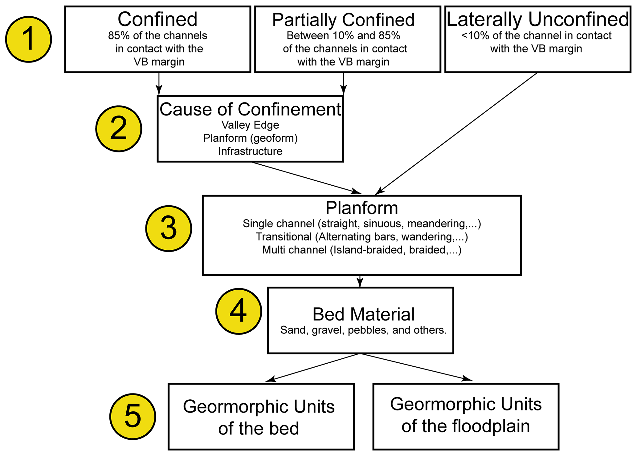
Figure 2Modified procedural tree of the River Styles framework (Modified from Nardini et al., 2020a). Source: created by the authors.
3.5 Semi-automated process using South Rivers Toolbox
The number of attributes that have been described in the previous sections, and which must be determined along the channel, require a great deal of time and effort. Thus, if they were established by manual measurements alone, geomorphological characterization using the River Styles framework would be impractical for large basins.
In 2020, within the GeoMagda project – financed by The Nature Conservancy NGO – different algorithms and morphometric analysis programs used worldwide at that time in the extraction of fluvial metrics were compared. Some improvements were also proposed by some of the authors of this paper and their own developments were programmed in Python (Nardini et al., 2020a, b, c; Nardini and Brierley, 2021).
The readjustments made it possible to generate an innovative integrated toolbox, composed of a sequence of tools oriented to the application of the River Styles Framework in a semi-automated way. In this context, later on the South Rivers Toolbox has been developed, allowing a considerable reduction in work time, ensuring a holistic and objective view in the calculation of fluvial parameters, as well as the possibility of replicating the analysis in any other river. It is currently open source and available as an experimental add-on for QGIS (Osores and Yépez, 2023), in the repository: https://github.com/vosores/SouthRiversToolbox (last access: 11 October 2022).
It is possible to visualize the pattern of local metrics of the Duqueco River (slope, elevation, drainage area, width of the floodplain and the active channel, confinement, specific stream power, among others) along the channel and how the variables are interacting.
In Fig. 3a, it is possible to visualize how the drainage area increases in a staggered manner, due to the entry of the main tributaries. As for the slope, it is steep in the first 36 km, with values reaching 0.15 m m−1, and then progressively decreases until the confluence with the Biobío River. Based on the above, the specific streampower of the channel (Fig. 3c), that depends on the slope and discharge of the channel, reaches its highest values in the middle-upper zone of the channel, where the combination of these variables is at its maximum.

Figure 3Spatial evolution of local metrics along the Duqueco River. Source: created by the authors.
Figure 3b shows the width of the floodplain and the confinement, with a very narrow floodplain at the head of the channel, practically confined along its entire length up to kilometer 42, from where the confinement is lost, showing a greater extension of the floodplain, and more freedom of movement of the channel.
As a result of the unsupervised classification that groups the attributes of the channel, there are 43 main River Styles and 57 complementary styles, by classifying on a second level with the floodplain geomorphic units, which are shown in Fig. 4. From the analysis of their lengths, 56.9 % of the fluvial styles are characterized by a single-channel planform, 37.4 % by a transitional type and only 5.6 % by a multi-channel type. As a visual aid, all the single-channel and transitional fluvial styles have been represented in green and blue tones, and the multichannel ones in red, so that the predominance of the first two over the small multichannel sections can be graphically appreciated.
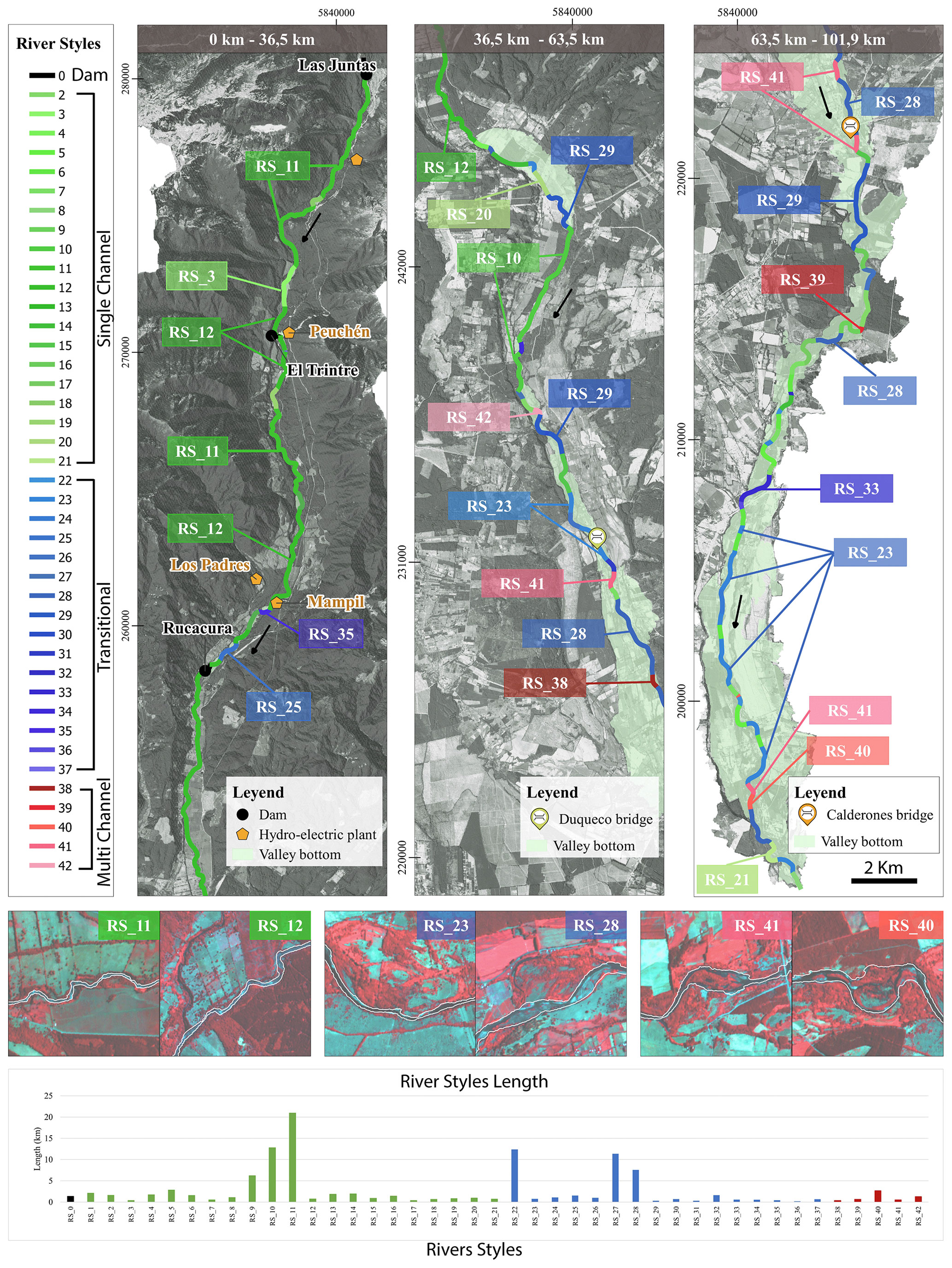
Figure 4Distribution of River Styles in the Duqueco River in 2019. Source: created by the authors.
RS_11 and RS_12 (both single channel), which predominate in the upper zone, are completely confined by the valley. The predominant fluvial styles are of transitional type, as is the case of RS_23 and RS_28, all of them with a “wandering” type planform, characterized by the predominance of the single channel type, with high frequency of lateral bars, a dominant arm and absence of abrupt widening in the channel envelope. Finally, in the few areas with multi-channel fluvial styles, R_40 and R_41 predominate, characterized by an “anabranching” type planform, which is characterized by separated channels, with one dominant arm, high island density and little or no presence of bars. Overall, the river can be classified into 3 main zones:
-
Duqueco River in the upper zone: it is characterized by the presence of RS_11 and RS_12, very similar, with a river totally confined, with a single channel planform and constrained sinuosity; there is not significant presence of any type of geomorphic unit and the riverbed is characterized by boulders and blocks, differing only by the cause of the confinement. The uppermost zone of the channel (RS_11) is limited by hillsides of the Andes Mountain range, downstream the hillsides are farther apart, and it is observed that RS_12 is confined by terraces. The specific stream power is not valid in this zone as it is strongly affected by the dams. Even so, the high slope value and low presence of geomorphic units identify it as a sediment transport zone. In the area downstream of the counter-embayment, the highest values of specific stream power are found, which makes it a zone of high erosion and sediment transport, but due to the confinement of the area, the river has little or no space to adjust, so it is not very sensitive to changes after an extreme event.
-
Duqueco River in the middle zone: area between the first widening of the floodplain up to the Duqueco bridge, characterized by the presence of the RS_10, RS_23, RS_28 and RS_29 fluvial styles. From this zone on, the riverbed is only boulders, still mostly confined by terraces, but the first unconfined or partially confined segments appear (e.g., RS_23, RS_28 and RS_29). The prevailing planform for RS-10 is of the confined sinuous single-channel type, and transitional for the other styles, due to the presence of bars, which is accentuated in the area near the Duqueco Bridge. In terms of behaviour, the specific stream power reaches its highest values at the beginning of the middle zone. Like the high zone, these points are confined, so erosion does not affect the shape of the river (lateral migrations). There is only one point with high specific stream power located near the Duqueco bridge, which is not confined (RS_23), so it is free to adjust its shape in the long term or during extreme events.
-
Duqueco River in the lower zone: this is the most extensive zone from the Calderones Bridge to the confluence with the Biobío River. It is characterized by the presence of R_23, R_28 and R_29 as transitional channels, with the occasional appearance of multi-channels such as RS_41. From this zone onwards, there is a marked widening of the floodplain, it is mostly unconfined, and multichannel segments increase, although single-channel type still prevails. The variety of fluvial styles is much wider, due to the higher frequency of UGs that give way to transitional or multichannel segments. In terms of behaviour, it is more prone to adjustments to the river's planform, being largely unconfined and possessing freedom of movement. On the other hand, the specific stream power has a low value, so it is a sedimentation zone (hence the large formation of UGs).
The tool we called South Rivers Toolbox, that supports the application of the aggregation and disaggregation framework, allowed us to obtain the hydromorphological attributes of the Duqueco River at different spatial scales, in a semi-automated way, with objective criteria; it ensures a higher degree of objectivity (making it replicable for other users) when compared to an analysis based solely on expert judgment and it makes it possible to develop this type of analysis for large basins.
In particular, the easiest hydromorphological attributes to extract are channel width, number of channels, sinuosity, and local confinement, all of which are automated by SRT tools. Their good computational performance depends only on the delimitation of Unitary Geographic Objects. On the other hand, the attributes of elevation, slope, drainage area and specific stream power, imply the “burning” of the DEM at an earlier stage, what generates a degree of inaccuracy in the measurements, which however, for practical purposes, is negligible. In the case of the specific stream power, it is called “coarse”, because it lacks the bankfull flow data along the river, and an estimate is made based on the empirical relationship between the discharge and the drainage area. It is concluded that, despite the lack of precision in its estimation, it provides an indication on erosive zones, which is fundamental to understand the behaviour of the river. Regarding the Planform, the programmed Excel spreadsheet assertively predicts its shape in most of the channel sections, with small manual corrections and expert judgment, with a performance like the work developed in the Baker River (Chile) by Nardini and Brierly (2021). This allows us to conclude that, despite requiring a significant amount of input data, the preparation is relatively easy to conduct, and the result is reliable, objective and, above all, replicable. Continuing with the hydromorphological attributes, but this time calculated on the homogeneous segments of the river, the confinement is obtained in a fully automated way with the SRT tools; the identification of its “cause” is an innovative process that has not been implemented in any other algorithm so far, so it has an added value.
By implementing the first stage of the River Styles framework in the Duqueco River, 43 main River Styles and 57 complementary styles were determined. The Duqueco River is characterized by a high rate of sediment transport in the upper and upper-middle reaches of the basin, up to the Duqueco Bridge area, while in the lower part of the basin, specific streampower decreases, sediment transport decreases and deposition zones progressively increase. The confinement restricts the lateral movement of the river in the upper and upper-middle zone, while freeing it in the lower zone. It is concluded that the area near the Calderones Bridge (Fig. 1) is one of the most critical since it has a high specific stream power and is not confined. This coincides with the existing evidence of the flood that occurred in July 2006, with the loss of connectivity of the bridge, and the flooding of the riparian population of the Llano Blanco sector (downstream of the Calderones Bridge).
In summary, we can state that this modified approach to River Styles classification, supported by SRT, as proposed by previous papers and this paper, provides a conceptual and working framework for understanding the complexity of the fluvial continuum, in addition to its usefulness as an important support tool for other important issues such as flood risk assessment.
The South Rivers Toolbox is freely available on the website: https://doi.org/10.5281/zenodo.7810989 (Osores and Yépez, 2023). This study's produced datasets are no longer available with the updating of the model. The complete and updated datasets are available from the corresponding author on request.
SY, FS, JV and RR planned the campaign; SY, FS, VO, AN, JV and RR performed the measurements; SY, FS, NV, AN and HP analyzed the data; SY and FS wrote the manuscript draft; SY, FS, VO, AN, HP and NV reviewed and edited the manuscript.
The contact author has declared that none of the authors has any competing interests.
Publisher’s note: Copernicus Publications remains neutral with regard to jurisdictional claims in published maps and institutional affiliations.
This article is part of the special issue “IAHS2022 – Hydrological sciences in the Anthropocene: Variability and change across space, time, extremes, and interfaces”. It is a result of the XIth Scientific Assembly of the International Association of Hydrological Sciences (IAHS 2022), Montpellier, France, 29 May–3 June 2022.
We would like to thank Planet for providing the RapidEYE and Planet Scope (nanosatellite) images used in this study free of charge. Also, to the TanDEM-X DEM GEOL08450 project for providing the high spatial resolution terrain elevation model.
This research has been supported by the Chilean economic development agency (CORFO) (grant no. 19BP-117424).
This paper was edited by Christophe Cudennec and reviewed by two anonymous referees.
Alber, A. and Piégay, H.: Spatial disaggregation and aggregation procedures for characterizing fluvial features at the network-scale: Application to the Rhône basin (France), Geomorphology, 125, 343–360, https://doi.org/10.1016/j.geomorph.2010.09.009, 2011.
Brierley, G. and Fryirs, K.: Geomorphology and river management: applications of the river styles framework, John Wiley and Sons, ISBN 978-1-405-11516-2, 2005.
Dirección General de Aguas (DGA): Balance hídrico de Chile, Santiago, Chile, 1987.
Duarte, C. M., Alonso, S., Benito, G., Dachs, J., Montes, C., Pardo Buendía, M., Ríos, A. F., Simó, R., and Valladares, F.: Cambio Global, Impacto de la actividad humana sobre el sistema Tierra, CSIC, Consejo superior de investigaciones científicas, ISBN 978-84-00-08452-3, 2006.
Eissa, A. E. and Zaki, M. M.: The impact of global climatic changes on the aquatic environment, Procedia Environ. Sci., 4, 251–259, https://doi.org/10.1016/j.proenv.2011.03.030, 2011.
Gilbert, J. T., Macfarlane, W. W., and Wheaton, J. M.: The Valley Bottom Extraction Tool (VBET): A GIS tool for delineating valley bottoms across entire drainage networks, Comput. Geosci., 97, 1–14, https://doi.org/10.1016/j.cageo.2016.07.014, 2016.
Hubert, P.: The segmentation procedure as a tool for discrete modeling of hydrometeorological regimes, Stoch. Env. Res. Risk A., 14, 297–304, https://doi.org/10.1007/PL00013450, 2000.
IPCC: Cambio climático 2014: Informe de síntesis. Contribución de los Grupos de trabajo I, II y III al Quinto Informe de Evaluación del Grupo Intergubernamental de Expertos sobre el Cambio Climático, Equipo principal de redacción, edited by: Pachauri, R. K. and Meyer, L. A., IPCC, Ginebra, Suiza, 157 pp., ISBN 978-92-9169-343-6, 2014.
Kleinhans, M. G. and van den Berg, J. H.: River channel and bar patterns explained and predicted by an empirical and a physics-based method, Earth Surf. Proc. Land., 36, 721–738, https://doi.org/10.1002/esp.2090, 2011.
McFeeters, S. K.: The use of the Normalized Difference Water Index (NDWI) in the delineation of open water features, Int. J. Remote Sens., 17, 1425–1432, https://doi.org/10.1080/01431169608948714, 1996.
Nardini, A. and Brierley, G.: Automatic river planform identification by a logical-heuristic algorithm, Geomorphology, 375, 107558, https://doi.org/10.1016/j.geomorph.2020.107558, 2021.
Nardini, A., Yepez, S., Zuniga, L., Gualtieri, C., and Bejarano, M. D.: A Computer Aided Approach for River Styles–Inspired Characterization of Large Basins: The Magdalena River (Colombia), Water, 12, 1147, https://doi.org/10.3390/w12041147, 2020a.
Nardini, A., Yepez, S., and Bejarano, M. D.: A Computer Aided Approach for River Styles — Inspired Characterization of Large Basins: A Structured Procedure and Support Tools, Geosciences, 10, 231, https://doi.org/10.3390/w12041147, 2020b.
Nardini, A., Yépez, S., Mazzorana, B., Ulloa, H., Bejarano, M. D., and Laraque, A.: A Systematic, Automated Approach for River Segmentation Tested on the Magdalena River (Colombia) and the Baker River (Chile), Water, 12, 2827, https://doi.org/10.3390/w12102827, 2020c.
Osores, V. and Yépez, S.: South Rivers Toolbox, Zenodo [software], https://doi.org/10.5281/zenodo.7810989, 2023.
Planet Team: Planet Imagery Product Specifications, March 2021, [software], https://www.planet.com/products/, last access: 22 March 2021.
Rojas, O.: Cambios Ambientales y Dinámica de Inundaciones Fluviales en una Cuenca Costera del Centro Sur de Chile (Tesis Doctoral), Universidad de Concepción, Concepción, http://repositorio.udec.cl/jspui/handle/11594/1773 (last access: 22 March 2021), 2015.
Urrutia de Hazbún, R. and Lanza Lazcano, C.: Catástrofes en Chile 1541–1992, in: Catástrofes en Chile 1541–1992, 439–439, https://bibliotecadigital.ciren.cl/handle/20.500.13082/18899 (last access: 22 March 2021), 1993.
Wentworth, C. K.: A scale of grade and class terms for clastic sediments, J. Geol., 30, 377–392, https://doi.org/10.1086/622910, 1922.