the Creative Commons Attribution 4.0 License.
the Creative Commons Attribution 4.0 License.
 | 18 Apr 2024
Hydrological Characterization of Mediterranean Catchments
Antoine Allam
Roger Moussa
Wajdi Najem
Claude Bocquillon
A climatic, physiographic, and hydrological homogeneity across the Mediterranean has been detected but not yet confirmed. Mediterranean climate is known for its precipitation seasonality and the alternation of humid winters and dry summers which conditions rivers flow regimes, landcover, agriculture and consequently any water resources management plan. Several physiographic traits could be also observed across the Mediterranean, like the elevated and exposed karstic features, and the cultivated and managed areas. Hydrologically, global river regimes were classified based on monthly average flows only, and Mediterranean regimes were identified under 3 of Haines' 15 global classes with a clear relation to Köppen's Mediterranean climate. Thus, we first studied the flow regimes of 55 Mediterranean catchments to verify if Mediterranean rivers fall into same regime class. Second, we characterized the Mediterranean hydrological response through different water balance functional models as advanced by Budyko, L'vovich and elaborated by Ponce & Shetty and Sivapalan. The water balance analysis highlighted the Mediterranean trend following the general climatic setting from the wet Northern region to the arid Southern region; it also showed hydrological homogeneity for mountainous karstic, and snow influenced catchments which yield the highest baseflows and runoff coefficients, especially if located in moderate climate.
- Article
(3841 KB) - Full-text XML
- BibTeX
- EndNote


Mediterranean; functional modeling; hydrological homogeneity; UPH 6; PUB
A climatic, physiographic, and hydrological homogeneity across the Mediterranean has been detected but not yet confirmed. Mediterranean climate is known for its precipitation seasonality and the alternation of humid winters and dry summers which conditions rivers flow regimes, landcover, agriculture and consequently any water resources management plan (Allam et al., 2020b). Several physiographic traits could be also observed across the Mediterranean, like the elevated and exposed karstic features, and the cultivated and managed areas that cover 30 % of the Mediterranean, with the symbolic olive tree that is considered one of its iconic bioindicators (Allam et al., 2020a). Hydrologically, global river regimes were classified based on monthly average flows only, and Mediterranean regimes were identified under 3 of the 15 global classes, finding a clear relation to Köppen's Mediterranean climate (Haines et al., 1988).
However, a specific Mediterranean hydrology is long to be defined yet and requires additional research to determine the relation between catchments climatic indices on one hand and the hydrological processes on the other. Since there is a great interest and benefit in sharing knowledge for sustainable water resources management between developed countries, mostly in the North, and underdeveloped countries in the South, a quest to understand the actual and future hydrological behaviour of Mediterranean catchments was launched through the analysis of hydrological similarity and variability. Thus, the objective is to carry out an extensive water balance analysis of Mediterranean catchments based on different water balance functional models to check the hydrological variability and similarity between all catchments and catchments within the same climatic classes, a similar work to the one carried out by Sivapalan on MOPEX dataset for the United States (Sivapalan et al., 2011). Thus, we characterised the Mediterranean hydrological response of 55 Mediterranean catchments through different water balance functional models as advanced by Budyko, L'vovich and elaborated by Ponce & Shetty and Sivapalan. The analysis of the functional models across the Mediterranean and through the climatic classes characterised furthermore the hydrological behaviour similarity and variability, and the competition between the water balance components of the Mediterranean catchments.
This paper is structured into 6 main sections; Sect. 1 Introduction, Sect. 2 presents the definition of the Mediterranean boundaries and a brief description of the hydrological datasets; Sect. 3 presents the methodology; Sect. 4 presents the hydrological characterisation results of the 55 selected Mediterranean catchments through water balance calculation based on the functional approach followed by a discussion in Sect. 5 and Conclusion in Sect. 6.
Mediterranean boundary, catchments, and hydrometric data
The Mediterranean refers to the sea and bordering region located in the middle of the European, African and Asiatic continents. With Köppen's classification the definition designated henceforth a moderate climate and extended geographically beyond the limits of the Mediterranean Sea (Köppen, 1936). However, the Mediterranean could be defined with several boundaries based on the field of practice; The hydrological boundary defined by the set of catchments draining towards the Mediterranean Sea was adopted for this study (Milano et al., 2013).
Since the geographic extent of the study is very wide, the delimitation of catchments was imported from international references. European catchments and some adjacent countries were imported from the Joint Research Centre (JRC) (De Jager and Vogt, 2010), catchments in the Middle East and Northern Africa were imported from HydroSHEDS database of World Wildlife Fund's project (Lehner and Grill, 2013).
The selection of catchments and their hydroclimatic data was very challenging as no single database gathers all the available stations in the region. The selected catchments cover a wide geographic domain spread across 15 countries in different physiographic settings. Despite the extensive work performed on data collection, some minor exceptions were still to be found. Some timeseries presented discontinuities and therefore only complete hydrological years were considered.
3.1 Climatic classification
With multiple studies raising serious concerns of climate shifts and aridity expansion in the region, Allam has established a new high resolution classification for hydrology purposes based on Mediterranean specific climate indices (Allam et al., 2020b). The proposed approach includes the use of classic climatic indices and the definition of new climatic indices mainly precipitation seasonality index Is or evapotranspiration threshold SPET both in line with river flow regimes. The classification was set and validated by WorldClim-2 at 1 km high resolution gridded data for the 1970–2000 baseline period. Climatic classes coincided with a geographical distribution in the Mediterranean ranging from the most seasonal and dry class 1 in the south to the least seasonal and most humid class 5 in the North, showing up the climatic continuity from one place to another and enhancing the visibility of change trends. The K-means classification shown in Fig. 1 is distributed into five classes.
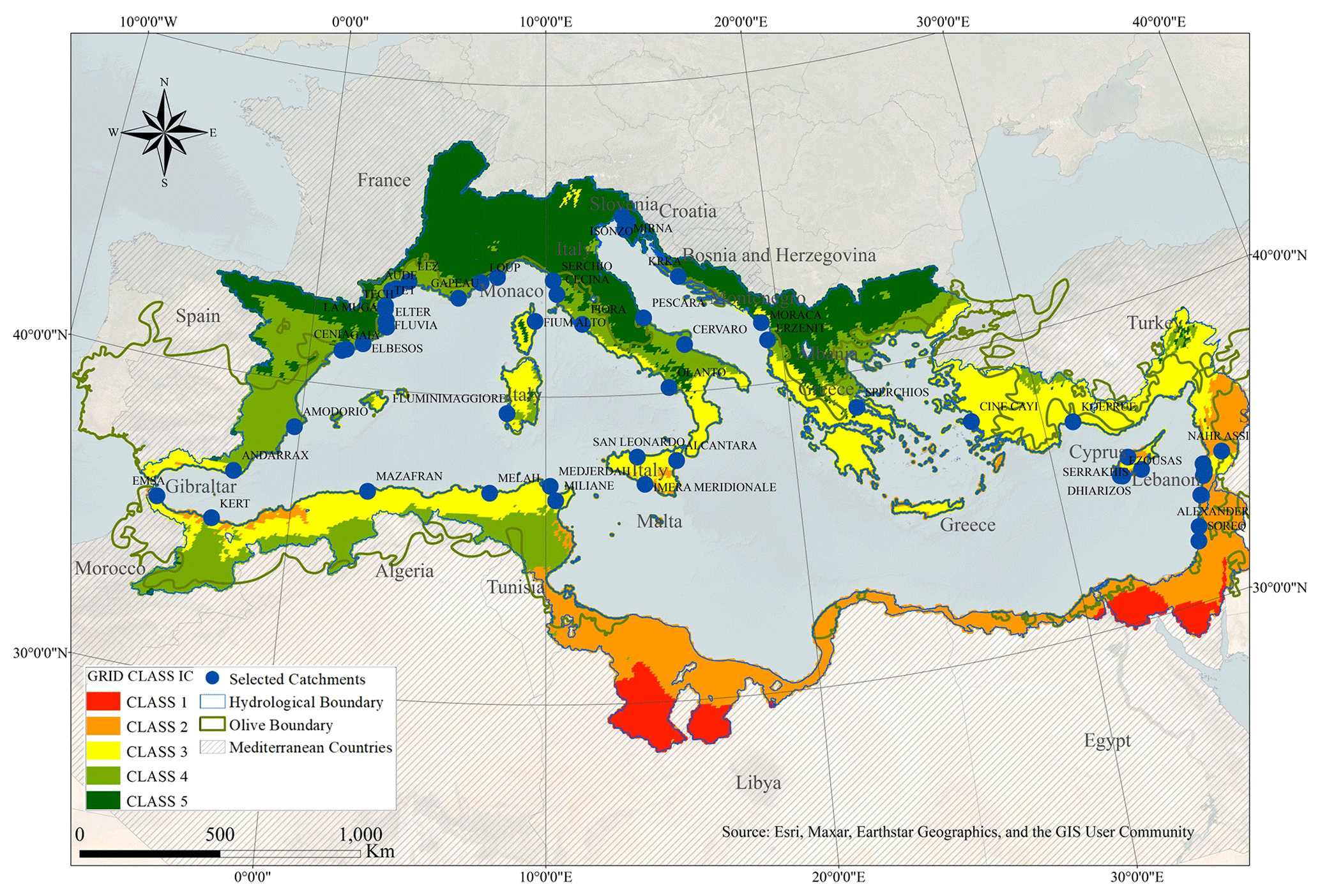
Figure 1Geographical distribution of the Mediterranean climatic classes (Allam et al., 2020b).
3.2 Functional modelling
The functional approach for annual water balance estimation took birth from the empirical model of L'vovich and the process-based approach of Horton; L'vovich advanced an empirical approach for the two-stage distribution of annual precipitation. The first stage separates the precipitation into surface runoff or quickflow S and wetting W with and the second stage partitioning separated the wetting W into Slow flow U and Vaporisation V with (L'vovich, 1979) while Horton introduced the ratio of the vaporisation V to the wetting W and named as Horton index, in a trial to search for catchments capacity to store the infiltrated water, depending on the soil type and the evaporation controlled by the vegetation type (Horton, 1933).
Ponce and Shetty have developed a simple conceptual model from the water balance equations to separate precipitation into different flows (Ponce and Shetty, 1995a, b). This model has been proposed as an alternative to empirical models, which have a limited applicability. Ponce et Shetty has adopted the same 2 partitioning stages as L'vovich and calibrated the initial abstraction coefficients surface runoff λs, baseflow λu, wetting potential Wp, and vaporisation potential Vp through the application of their equations on the same database and tented to classify the climatic regions according to the range of values they obtained. The mountainous conifer forests of North Africa close to the Mediterranean region has shown high Wp with low λs and a high Vp with high λu.
In the empirical approach, the annual water balance is estimated based on a systematic analysis of long-term rainfall and runoff series observed in different climatic regions and an empirical analysis of the effect of physiographic and climatic descriptors on the water balance (Sivapalan et al., 2011). The value of the empirical approaches lies in the simplicity of the relations which govern the annual assessment on the long term, and which appeared from the coevolution and the self-organization of climates, soils, topography and vegetations of the different regions.
4.1 The water balance partitioning model of L'vovich
The water balance partitioning was carried out and reproduced accurately the empirical relations for most of the catchments. The charts have shown the well-marked interannual variability for all water balance components, with the same observation for the inter-catchment variability with different ranges between catchments. We set as an example Nahr Ibrahim catchment in Lebanon which is highly watered with a mean annual precipitation MAP of 1450 mm, yielding a mean annual runoff MAQ of 1052 mm; a surface flow S ranging between 100 and 550 mm, a baseflow U showing remarkable high values ranging between 200 and 1350 mm, and vaporisation V showing an upper limit, reached every year due to water availability in contrast with other catchments. The water balance partitioning charts are presented in Fig. 2.
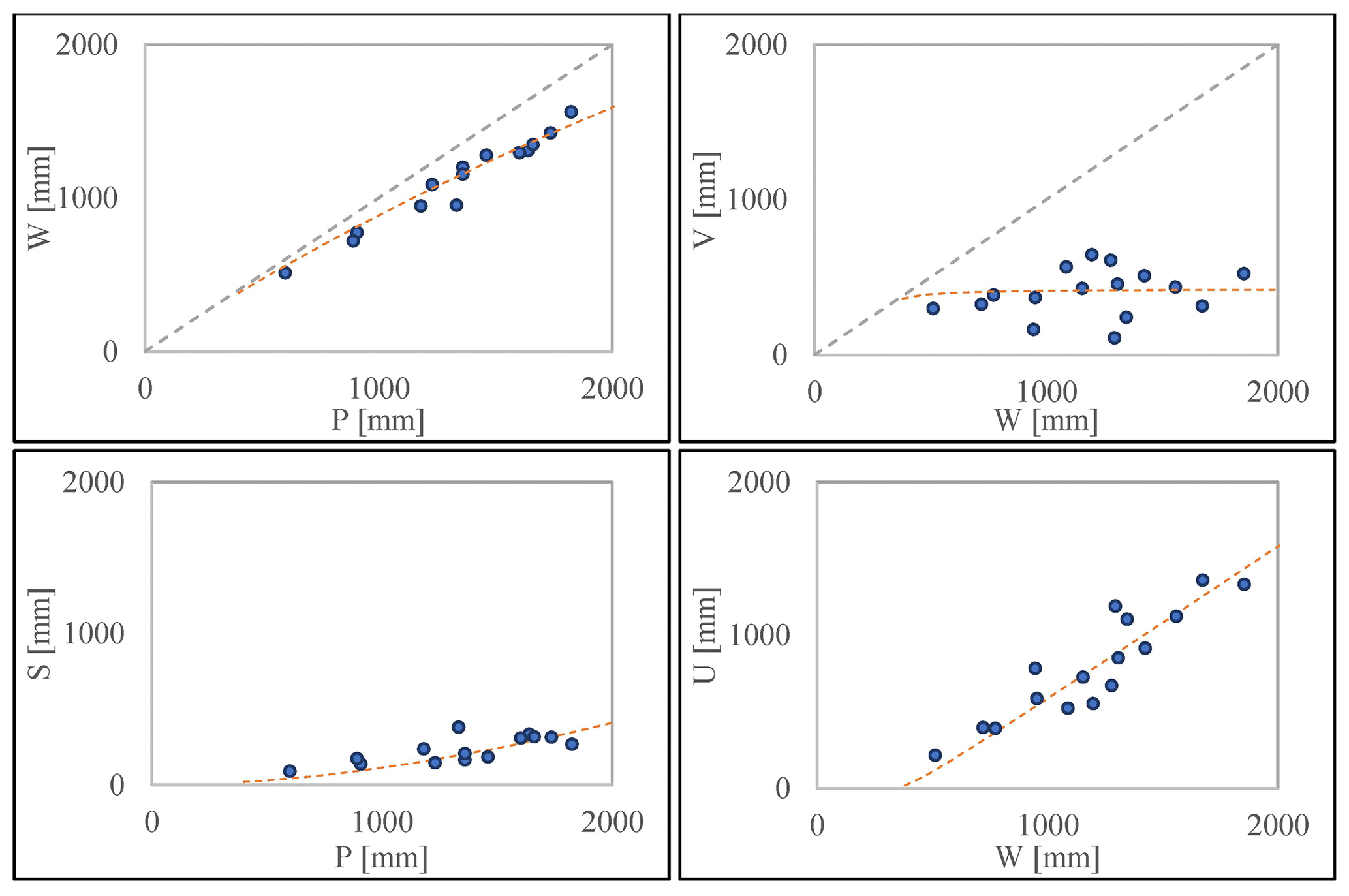
Figure 2L'vovich water balance components proportional curves extracted for Ibrahim, Lebanon.
4.2 The conceptual water balance model of Ponce and Shetty
The Ponce et Shetty models were fitted over L'vovich partitioning charts. Some catchments did not yield very good results, this inaccuracy returns to either interrupted flows by dams and lakes, catchments interconnection or simply poor quality of data. The sensitivity analysis conducted on the US MOPEX dataset, showed that Ponce and Shetty curves fitting was insensitive to extremes and that the distribution returned a linear fit (Sivapalan et al., 2011). Those extremes were observed in the Mediterranean wherever the flow regime was dominated by the groundwater runoff, case of Nahr el Assi in Lebanon; or wherever the precipitation was very low, case of Andarax in Spain, or Alcantara in Italy. The runoff and baseflow threshold of all the catchments according to Ponce and Shetty (1995a) are summarized in Table 1 and shown in red on the same charts for Ibrahim in Fig. 2.
Table 1Summary of the fitting curves parameters according to Ponce and Shetty (1995a).
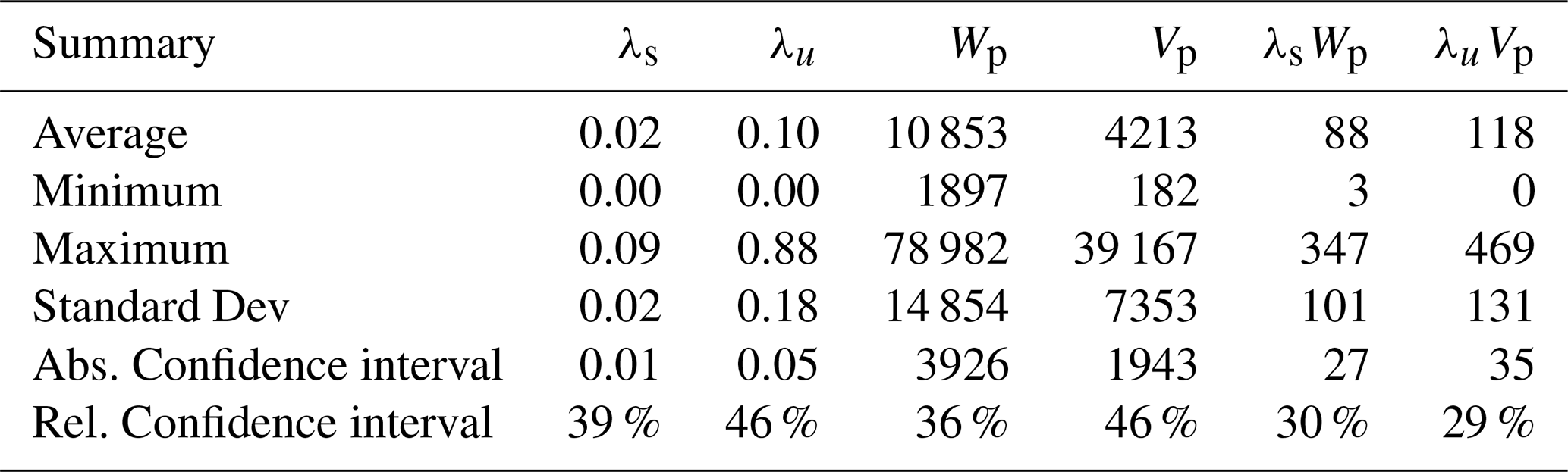
The spatial distribution of Ponce and Shetty water balance parameters reflected a wide geographical variability across the Mediterranean without any clear pattern or regional clustering despite some adjacent catchments yielding neighbouring values. The French catchments yielded the lowest values for all parameters with both λsWp and λuVp below 100 mm except for Hérault river (λsWp=122 mm; λuVp=1 mm). In Cyprus, λsWp show close values ranging between 175 and 350 mm. These values are among the highest in the Mediterranean due to the high soil permeability on the island; this is confirmed with the high wetting potential Wp values ranging between 5000 and 9000 mm. The Lebanese coast have a wide variability of λsWp ranging from 7 to 270 mm between adjacent catchments as well as for Wp ranging from 5000 to 27 000 mm (except for Nahr el Assi in Lebanon); same observations could be described for λuVp and Vp variability. We noticed across the Mediterranean, some matching catchments which share remarkable water balance similarities despite their geographical, climatic, or landscape difference. These catchments could be considered twin catchments like Lez in Franc and Erzenit in Albania (CC4); Fium-alto in France and Fluminimaggiore in Italy (CC4); Mirna in Croatia and Alento in Italy (CC5). The water balance similarity between these catchments could be caused by an underlying physiographic similarity like snow or karst components which make these catchments interesting to examine closely.
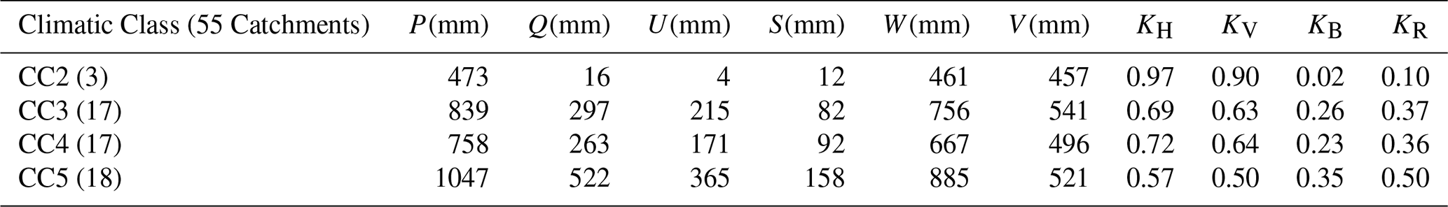
Table 2Summary of the water balance components and nondimensional metrics averaged by climatic classes.
The diversity of both microclimates and physiography between catchments stands behind the water balance variability as hydrological response on the same climatic forcing differs according to catchments' landform, landcover, soil types and other physiographic features, and despite some close catchments between Spain, France and Italy, no geographical pattern was detected.
4.3 The nondimensional water balance functional model of Sivapalan et al. (2011)
We verified the nondimensional formulation as suggested by Sivapalan et al. (2011) to check if any water balance pattern could be extracted from Mediterranean site-specific water balance results that express their common hydrological behaviour. The different non dimensional water balance components W*, S*, U* and V* were estimated from the values of W, S, U and V. A summary is shown here representing the annual average of all the catchments and coloured according to their climatic classes in Fig. 3 in a trial to discover any pattern behind, the average values of each climatic class were also added. The charts show the nature of competition between different water balance components of Mediterranean catchments as suggested by Sivapalan, where, at a first stage, quick flow S* is competing with the storage W* and at a second stage slow flow U* is competing with vaporisation V*. The climatic illustration of W* and S* vs shows that this competition is gradually evolving from climatic CC2 in the South, where low precipitation and low quick flows dominate, to CC5 in the North where high precipitation and high quick flows dominate.
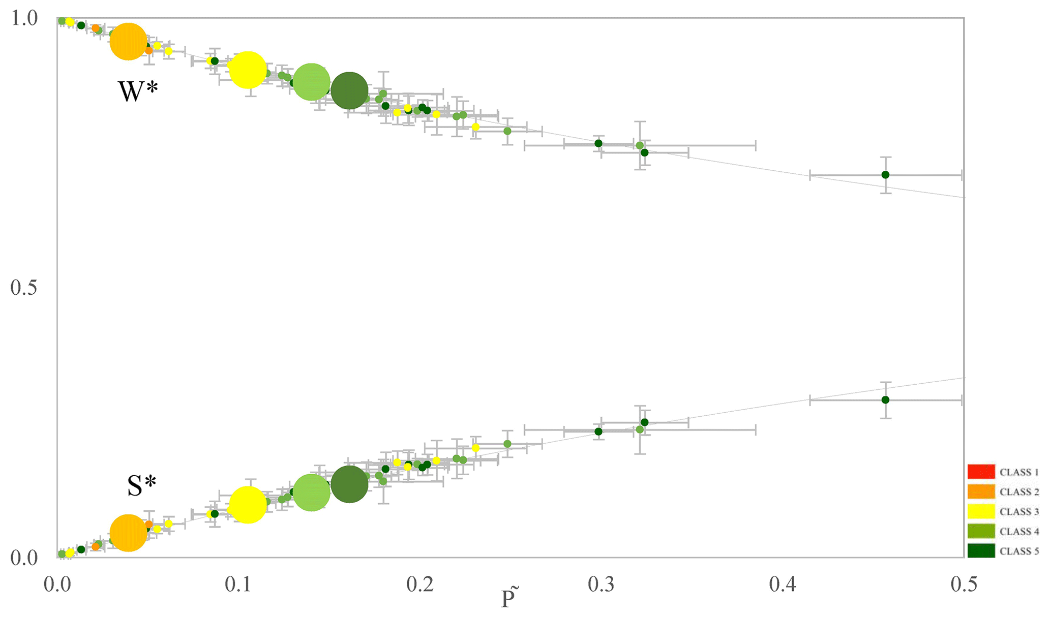
Figure 3Inter-catchment variability of mean annual water balance nondimensional estimates of W* and S* versus annual climatic driver for all 55 catchments coloured according to climatic classification. Small points represent each catchment data and large points represent class averages and dashed lines are theoretical.
The maps in Fig. 4 show an interesting spatial distribution where KH and KV gradually decrease from South to North while KB and KR gradually decrease from North to South, nonetheless some exceptions were noticed where some Lebanese catchments showed an inverted distribution. The geographical distribution coincided with the Mediterranean climatic classification, therefore we searched for which climatic index is mostly affecting this distribution and found that the water balance metrics of all catchments are slightly correlated with the mean annual aridity index (R=0.55) which is also correlated to the non-dimensional aridity index φ with R=0.63 (r2=0.4), hence supporting Sivapalan finding on US MOPEX data where r2=0.46. It is therefore possible to say, to certain extent, that annual water balance metrics KH and KV increase while KB and KR decrease when seasonality increases, which suggests that intra-annual variability is responsible for the inter-catchment variability. We also noticed that some CC3 and CC4 catchments yielded lower aridity φ than CC5 which is unusual. And looking to their physiography, we noticed that those were mountainous karstic catchments under snow influence, case of Nahr Ibrahim in North Lebanon which yielded the highest slow flow peaking at 0.71 and total runoff at 0.94, due to high snowmelt contribution and high karstification with a similar observation for Spercheios, Nahr el Kalb and other.
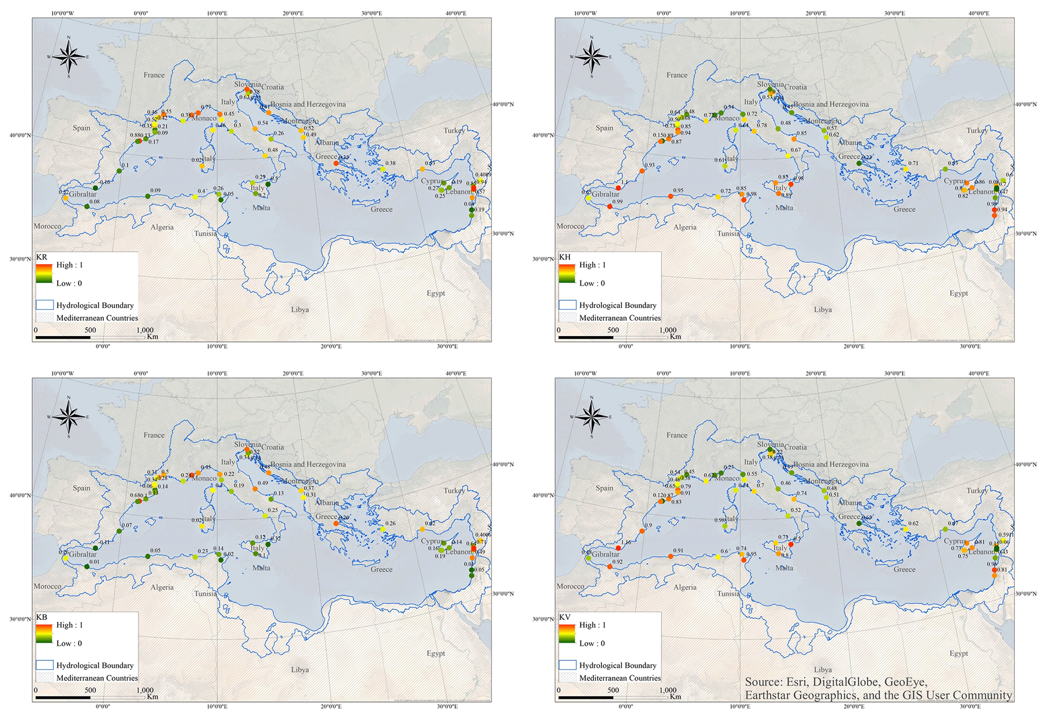
Figure 4Spatial distribution of the water balance Runoff index KR, Horton index KH, Baseflow index KB, and Vaporisation index KV.
This finding completes the one advanced by Sivapalan et al. (2011) on baseflow metric variability stating that the wettest catchments have yielded the highest baseflow contribution and that soil types and topographic features govern the subsurface flow as part of the self-organisation of the vegetation with the climate as proposed by Horton (1933).
L'vovich (1979) model showed a breakdown of the annual water balance advancing more info on the surface runoff S and groundwater runoff U which indicates the physiographic forcing on hydrology. It also permitted a precise interannual comparison with precious info on water resources. Ponce and Shetty (1995a) generalized L'vovich model from annual values to continuous curves which helps in predicting the available water resources throughout the years. The model equations are dependent from runoff threshold parameters, specific for each catchment which permits more precise inter catchment comparison, highlighting Mediterranean variability. In addition, these parameters also reflect the physiographic forcing on hydrology. Sivapalan et al. (2011) model went further with non dimensionalising Ponce and Shetty equations which permitted in addition to interannual and inter catchment comparison, an inter climatic and inter physiographic comparison, useful in our study to uncover the variability and homogeneity of Mediterranenan catchments through nondimensional metrics KH, KB, KR and KV. These metrics showed the special setting of Mediterranean catchments in correspondence to aridity index . Sivapalan model showed a space time symmetry where functional curves fit both to individual catchments for interannual analysis or to mean annual water balances for inter catchment analysis despite their variability.
The calculation of the dimensionless water balance metrics KH, KB, KV, KR endorsed the previous findings as aridity index turned to be a primary determinant of the mean annual water balance. The charts showed that KH and KV were increasing with aridity, suggesting that in general, the vaporisation V (energy) takes over the wetting W and consequently the slow flow component U while moving towards arid catchments. In reverse KB and KR were decreasing with aridity except for, once again, mountainous catchments which showed to be independent to climate variability. Therefore we state that “In the Mediterranean, the mountainous, snow and karst influenced catchments yield the highest slow flow and runoff especially if located in high seasonal region (Southern Mediterranean CC3 regions) where precipitation are concentrated in winter and runoff are concentrated in winter and spring seasons, when minimum vegetation cover the land and vaporisation (or evapotranspiration) is at lowest, part of the self-organisation of the vegetation with the climate as proposed by Horton (1933) but at the intra-annual scale.”
The water balance models highlighted similar Mediterranean trends following the general Mediterranean climatic setting from the wet Northern region to the arid Southern region and showed hydrological homogeneity for specific physiographic classes like mountainous snow and karst influenced catchments. However, to characterise the Mediterranean hydrological variability and homogeneity, we will rely on baseflow and runoff coefficients Kr and Ku which are also useful to estimate catchments' resources.
These observations and findings shall be verified and completed with the Canonical Correlation Analysis to first discover which specific climatic and physiographic indices govern the Mediterranean hydrological behaviour, second predict the water balance coefficients values on all Mediterranean catchments and third check the climatic evolution impact on the hydrological behaviour of Mediterranean catchments in case of RCP scenarios.
All the climatic data are freely available online. The WorldClim-2 data are available from the WorldClim website at https://www.worldclim.org/data/worldclim21.html (Fick and Hijmans, 2017). The ground weather station data are available from the Global Historical Climatology Network website at https://www.ncei.noaa.gov/products/land-based-station/global-historical-climatology-network-daily (NCEI, 2023). The ALADIN and CCLM simulations used in the current work can be downloaded from the Med-CORDEX database at https://www.medcordex.eu/ (CORDEX, 2023).
Streamflow time series data used in this study were collected from several national and regional hydrological agencies and services. Catalan Agency for Water – ACA, Hydrological Automatic Information System – SAIH (Spain); Banque HYDRO (France); Superior Institute for the Protection of Environmental Resources – ISPRA (Italy); Slovenian Republic Environment Agency – ARSO; Croatian Meteorological and Hydrological Service – DHMZ; Litani River Authority – LRA (Lebanon); Greek ministry of Environment and Energy – YPEKA; Système d'Informations Environnementales sur les Ressources en Eau et leur Modélisation – SIEREM (Algeria, Morocco, and Tunis); Global Runoff Discharge Centre – GRDC (Cyprus, Turkey, and Israel); Mediterranean Hydrological Cycle Observing System – MedHyCOS (Albania, Cyprus, and Montenegro) for three sub catchments.
All the authors (AA, RM, WN and CB) contributed to the conceptualization and methodology of the study as well as drafting, reviewing, and editing the article. AA developed the climatic classification and functional modeling. AA, RM, WN and CB carried out the validation and analysis of the results.
At least one of the (co-)authors is a guest member of the editorial board of Proceedings of IAHS for the special issue “IAHS2022 – Hydrological sciences in the Anthropocene: Variability and change across space, time, extremes, and interfaces”. The peer-review process was guided by an independent editor, and the authors also have no other competing interests to declare.
Publisher's note: Copernicus Publications remains neutral with regard to jurisdictional claims in published maps and institutional affiliations.
This article is part of the special issue “IAHS2022 – Hydrological sciences in the Anthropocene: Variability and change across space, time, extremes, and interfaces”. It is a result of the XIth Scientific Assembly of the International Association of Hydrological Sciences (IAHS 2022), Montpellier, France, 29 May–3 June 2022.
The authors would like to thank the editor Christophe Cudennec, first reviewer Mohammad Merheb and the anonymous second reviewer for their constructive comments. We would also like to thank the Med-CORDEX providers for making their Regional Climate Data available as well as all national and international hydrological agencies and services.
This paper was edited by Christophe Cudennec and reviewed by Mohammad Merheb and one anonymous referee.
Allam, A., Moussa, R., Najem, W., and Bocquillon, C.: Specific climate classification for Mediterranean hydrology and future evolution under Med-CORDEX regional climate model scenarios, Hydrol. Earth Syst. Sci., 24, 4503–4521, https://doi.org/10.5194/hess-24-4503-2020, 2020a.
Allam, A., Moussa, R., Najem, W., and Bocquillon, C.: Hydrological Cycle, in: Water Resources in the Mediterranean Region, edited by: Zribi, M., Elsevier, 350, https://doi.org/10.1016/B978-0-12-818086-0.00001-7, 2020b.
CORDEX: https://www.medcordex.eu/, last access: 8 March 2023.
De Jager, A. L. and Vogt, J. V.: Development and demonstration of a structured hydrological feature coding system for Europe, Hydrol. Sci. J., 55, 661–675, https://doi.org/10.1080/02626667.2010.490786, 2010.
Fick, S. E. and Hijmans, R. J.: WorldClim 2: new 1‐km spatial resolution climate surfaces for global land areas, Int. J. Climatol., 37, 4302–4315, 2017 (data available at: https://www.worldclim.org/data/worldclim21.html, last access: 8 March 2023.).
Haines, A., Finlayson, B., and McMahon, T.: A global classification of river regimes, Appl. Geogr., 8, 255–272, https://doi.org/10.1016/0143-6228(88)90035-5, 1988.
Horton, R. E.: The Rôle of infiltration in the hydrologic cycle, Eos, Transactions American Geophysical Union, 14, 446–460, https://doi.org/10.1029/TR014i001p00446, 1933.
Köppen, W.: Das geographische System der Klimate, Borntraeger, 1936.
Lehner, B. and Grill, G.: Global river hydrography and network routing: baseline data and new approaches to study the world's large river systems, Hydrol. Process., 27, 2171–2186, 2013.
L'vovich, M. I.: World water resources, present and future, GeoJournal, 3, 423–433, https://doi.org/10.1007/bf00455981, 1979.
Milano, M., Ruelland, D., Fernandez, S., Dezetter, A., Fabre, J., Servat, E., Fritsch, J.-M., Ardoin-Bardin, S., and Thivet, G.: Current state of Mediterranean water resources and future trends under climatic and anthropogenic changes, Hydrol. Sci. J., 58, 498–518, https://doi.org/10.1080/02626667.2013.774458, 2013.
NCEI: Ground weather station data, Global Historical Climatology Network [data set], https://www.ncei.noaa.gov/products/land-based-station/global-historical-climatology-network-daily, last access: 8 March 2023.
Ponce, V. M. and Shetty, A. V.: A conceptual model of catchment water balance: 1. Formulation and calibration, J. Hydrol., 173, 27–40, https://doi.org/10.1016/0022-1694(95)02739-C, 1995a.
Ponce, V. M. and Shetty, A. V.: A conceptual model of catchment water balance: 2. Application to runoff and baseflow modeling, J. Hydrol., 173, 41–50, https://doi.org/10.1016/0022-1694(95)02745-B, 1995b.
Sivapalan, M., Yaeger, M. A., Harman, C. J., Xu, X., and Troch, P. A.: Functional model of water balance variability at the catchment scale: 1. Evidence of hydrologic similarity and space-time symmetry, Water Resour. Res., 47, W02522, https://doi.org/10.1029/2010WR009568, 2011.