the Creative Commons Attribution 4.0 License.
the Creative Commons Attribution 4.0 License.
 | 16 Nov 2021
Validation of the altimetry-based water levels from Sentinel-3A and B in the Inner Niger Delta
Adama Telly Diepkilé
Flavien Egon
Fabien Blarel
Eric Mougin
Frédéric Frappart
The comprehension of water level fluctuations and the sustainability of the Inner Niger River Delta (IND) is a major concern for the scientific community, but also for the local population. Located in the centre of Mali, the heart of the Sahel, the delta is characterised by a floodable area of more than 32 000 km2 during the rainy season, which contributes very strongly to the vitality of local ecosystem, and is consequently classified as a Ramsar site under the international Convention for Wetlands. In addition, the Delta acts as an environmental and socio-economic development barometer for the entire sub-region. Nowadays, we can observe an increasing fragility of the delta due to climate change, desertification and human activities, and justifies the need for permanent monitoring. The present study is based on the recent successes of radar altimetry, originally designed to monitor the dynamics topography of the ocean, and now very frequently used to retrieve inland water levels, of lakes, rivers, and wetlands. Previous studies evaluated the performances of several radar altimetry missions including Low Resolution Mode (LRM) (Topex-Poseidon, Jason-1/2/3, ERS-2, ENVISAT, and SARAL, and Synthetic Aperture Radar (SAR) Sentinel-3A missions for water level retrievals over 1992–2017. More than 50 times series of water levels were build at the crossing between water bodies and Sentinel-3A and 3B over 2016–2020. Twenty-four comparisons between in-situ and altimetry-based time-series of water levels were achieved over the IND. RMSE generally lower than 0.7 m and r higher than 0.9 were obtained.
- Article
(3841 KB) - Full-text XML
- BibTeX
- EndNote


Radar altimetry (RA) has been experiencing numerous inovations in terms of acquisition mode (from Low Resolution Mode – LRM – to Synthetic Aperture Radar – SAR –, and even Interferometry SAR – InSAR) and data processing over all types of Earth surfaces (Abdalla et al., 2021). Owing to their availability over almost 30 years, since the launch of Topex/Poseidon and ERS-1 missions in and 1991 and 1992, respectively, the two first missions to provide high accuracy measurements (Stammer and Cazenave, 2017), RA data are increasingly used, over land, to globally monitor the water levels of rivers, lakes and reserveroirs, wetlands and floodplains (Birkett et al., 2011; Crétaux et al., 2017). To ensure the confidence in the reliability of RA-based water levels, it is necessary to determine their quality through comparisons against in-situ measurements. In these operations are routinely performed over the ocean at different calibrration/validation sites (e.g., Bonnefond et al., 2011; Mertikas et al., 2018), few of these facilities are available over land, except at Lake Issykkul, in Kyrgyzstan (Central Asia) (Crétaux et al., 2009). Sentinel-3A and 3B are two of the most recently launched RA missions. They operate in SAR and use the Open-Loop (OL) or Digital Elevation Model (DEM) tracking mode designed to reduce the loss of tracking over hilly areas (Biancamaria et al., 2017; Taburet et al., 2020). Very few studies evaluated the accuracy of both Sentinel-3A and 3B over inland water bodies, and mostly over lakes (Frappart et al., 2021; Kittel et al., 2021; Shu et al., 2021).
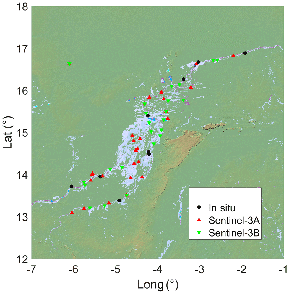
Figure 1The Niger Inner Delta in Mali. Flooded areas appear in blue. They are made available by http://floodobservatory.colorado.edu/ (last access: 1 June 2021). Locations of in-situ gauges, and VS from Sentinel-3A and B are represented using black dots, red and green triangles, respectively.
Owing the availability of a large number of in-situ measurements, the IND has often been chosen as a study area for validating RA-based water levels (Frappart et al., 2015; Goita and Diepkile, 2012; Normandin et al., 2018). In this study, RA-based water levels defined at the cross-sections of Sentinel-3A and 3B ground-tracks and river and floodplains in the IND were compared to in-situ water stages.
2.1 The Inner Niger Delta
The study area the inner delta of the Niger River, located in the centre of the Sahelian zone of West Africa, precisely in Mali (Fig. 1a). It extends between latitudes 13 to 17∘ N, and longitudes 2 to 7∘ W (Fig. 1). Its floodable area is estimated at 32 000 km2 (Goita and Diepkile, 2012; Mahé et al., 2009; Seiler et al., 2009; Zwarts et al., 2005). The Delta presents a rather particular ecological environment by the fact that it separates two zones with very precarious climatic conditions: on the one hand, the desert Sahara dominated by sand dunes, and on the other hand, the Sahel which is characterized by recurrent droughts.
2.2 Radar altimetry data from Sentinel-3A and 3B
Sentinel-3 was developed by the European Space Agency (ESA) in the framework of the COPERNICUS program. Two satellites are already operating: Sentinal-3A and 3B launched on 16 February 2016 and 25 April 2018, respectively. They are orbiting at 814.5 km altitude on a 98.65∘ inclination sun-synchronous orbit with a 27 d repeat period and an equatorial ground-track spacing of ∼ 105 km. Sentinel-3A and 3B were placed on the same orbit with a phase difference of 180∘. The satellites payloads is composed of SRAL (SAR Radar ALtimeter), a dual-frequency SAR altimeter operating at Ku (13.575 GHz) and C (5.41 GHz), bands, a Microwave Radiometer (MWR) sensor for wet path delay correction over the ocean, and a triple system for Precise Orbit Determination (POD) including a GPS receiver, a LRA and a DORIS instrument (Donlon et al., 2012). The data used in this study are the ones necessary to compute water levels over land (see (Frappart et al., 2021) and Sect. 3). They are made available at: http://ctoh.legos.obs-mip.fr (last access: 15 May 2021).
2.3 In-situ water levels
Records from 10 gauge stations located in IND (see Fig. 1) were provided by the Malian hydrological service, Direction Nationale de l'Hydraulique (DNH). In this study, we used the time series of water levels from February 2016 to December 2020.
Time-series of water level were produced at the cross-section between an altimeter ground-track and a water body using the the Altimetry Time-Series (AlTiS) software (Frappart et al., 2021). From the Geophysical Data Records (GDR) which contain the along-track altimetry data, AlTiS computed the altimeter height (h) as described in (Crétaux et al., 2017) and Eq. (1):
where H is the altitude of the satellite on its orbit, R the range or distance between the satellite and the surface, ΔRion, ΔRdry, ΔRwet, ΔRsol, ΔRpol, are the corrections to apply to the range to account for the delay introduced by the ionosphere, the troposphere (dry and wet components), and the effects of the solid Earth and pole tides, and N is the geoid model. Following Frappart et al., 2006), the ranges derived from Offset of Center of Gravity (OCOG) (Wingham et al., 1986) were used as they were found to provide more accurate water levels.
Then, the valid height values were manually selected through AlTiS Graphical User Interface (GUI). Once the valid data are selected, the time-series of water levels is generated computing the median of the heights for each altimetry cycle (i.e., every 27 d for Sentinel-3A and B).
The altimetry-based time-series of water levels generated over the rivers in the Inner Niger Delta were compared to in-situ water stages using the Root-Mean-Square Error (RMSE), Relative (ratio of the RMSE to the mean annual amplitude of the water level at the station multiplied by 100) RMSE (RRMSE), and the Pearson correlation coefficient (r).
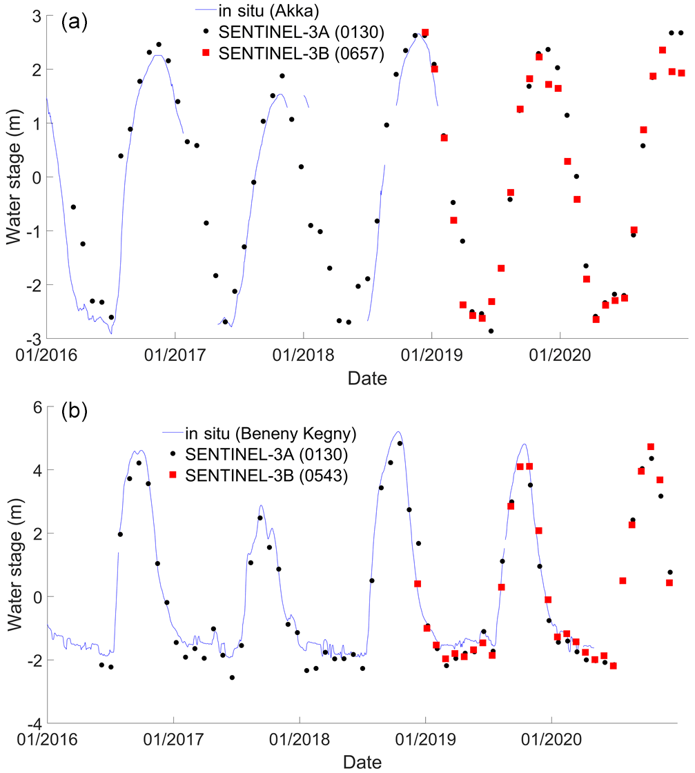
Figure 2Time-series of water levels from the in-situ gauge stations (blue) of Beneny Kegny (a) and Akka (b), Sentinel 3A (black dots) and 3B (red squares).
Several tenths of RA-based time-series of water levels were generated over the IND (rivers and floodplains) using Sentinel-3A and 3B data: 28/24 on the Sentinel-3A/3B RA ground-tracks (Fig. 1). They offer a dense network of RA Virtual Stations (VS) were time-series of water levels are estimated. Two examples of comparisons of in-situ and RA-based time-series of water level are presented in Fig. 2. The first one to a cross-section of Sentinel-3A and 3B located on the Bani River, a south-west tributary to the Niger River, at (4.74∘ W, 13.51∘ N), the second one one to a cross-section of Sentinel-3A and 3B located on the Niger River at (4.27∘ W, 15.46∘ N), on the nort central part of the IND. Comparisons were made with gauge records of Beneny Kegny (4.917∘ W, 13.383∘ N) and Akka (4.233∘ W, 15.400∘ N) stations, respectively. The distance to the Sentinel-3 SV is 28 and 8 km, respectively.
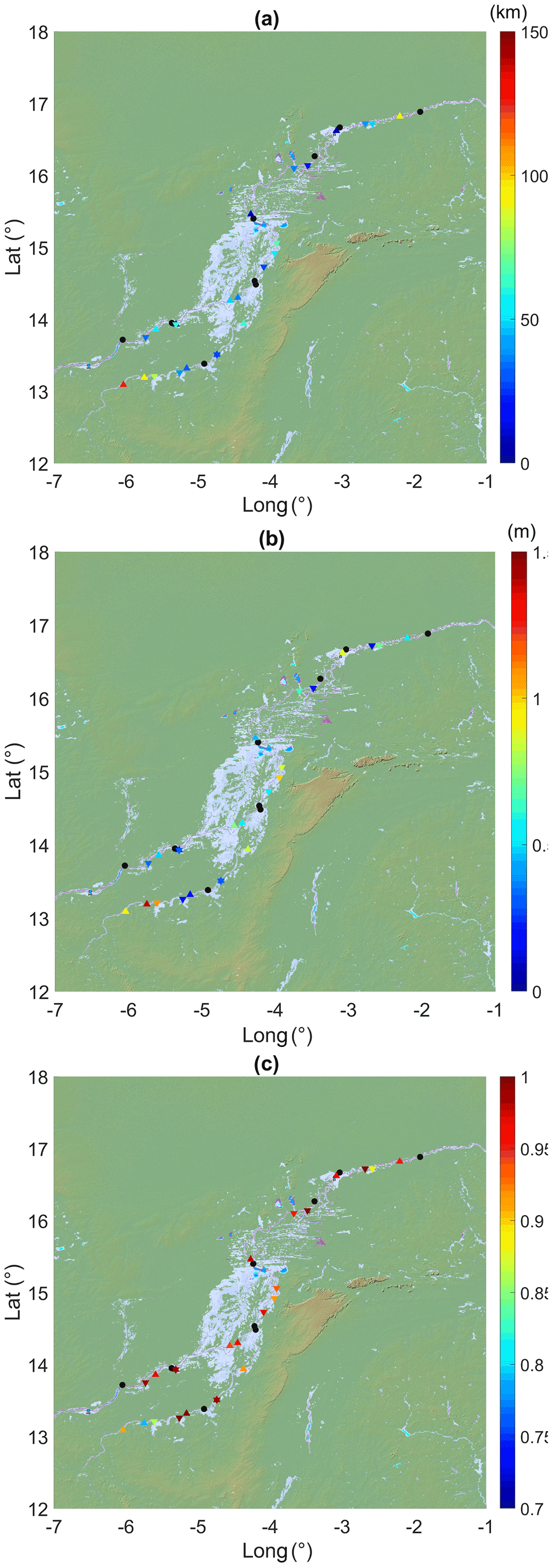
Figure 3Comparisons between in-situ and altimetry- based water levels for Snetinel-3A (upward-pointing triangles) and 3B (downward-pointing triangles) over the IND: (a) distance between in in-situ stations and VS, (b) RMSE (m), (c) R.
RA-based water levels exhibit similar temporal variations as the in-situ gauge stations, with a well-marked seasonal cycle that can reach 6 m (Fig. 2). RMSE of 0.35 m/0.30 m, and r of 0.99/0.99 were found at Beneny Kegny Akka for Sentinel-3A and 3 B, respectively, and RMSE of 0.45 m and r of 0.98 at Akka for Sentinel-3A. As too few in-situ measurements were collected or made available for the Akka gauge station during the period of operation of Sentinel-3B, we were unable to estimate RMSE, RRSME and r for Sentinel-3B. Nevertheless, as RA-based water levels from Sentinel-3A and Sentinel-3B exxhibit very similar temporal variations and taking into account the good agreement between in-situ and Sentinel-3A-based water levels, similar perfomances can be expected from Sentinel-3B based water stages. This latter example brings into focus the strong interest of radar altimetry to provide a continuous monitoring of water levels in case in-situ gauge stations stopped operating for a reason or another.
The same evaluation parameters (distance between the VS and the in-situ station, RMSE, RRMSE and R) were estimated for 12 Sentinel-3A VS and 12 Sentinel-3B VS. They are presented on Fig. 3, except the RRMSE not shown here. Comparisons were made on distances between the in-situ station and the VS ranging from 7 to 126 km (Fig. 3a). The RMSE range from 0.15 to 1.39 m, with 13 values over 0.5 m (Fig. 3b). If these values can be considered quite high, the corresponding RRMSE are all lower or equal 20 %, and 19 RRMSE values out of 24 are below 15 %. Correlations are all higher or equal to 0.79 (Fig. 3c). Twenty one out of 24 r values are above 0.9, and even, 16 of them are higher than 0.95, confirming the good accuracy of Sentinel-3 based water stages reported in previous studies over rivers (e.g., Bogning et al., 2018; Kittel et al., 2021; Normandin et al., 2018). The high RMSE values can be accounted for the distances between the in-situ gauges and the SV. If the temporal variations are likely to exhibit a similar pattern over distances of several tenths of kilometers, the seasonal amplitude can be affected by changes in depth and width of the river along of the river network. As a consequence, the correlation can still present high values when the RMSE increases. This situation is what is observed here: high correlation values were estimated, slightly decreasing as the distance increases, but RMSE generally increases with the distance (e.g., RMSE of 0.93 and 1.39 m were obtained fro distances of 126 and 93 km, respectively, for corresponding r of 0.79 and 0.91).
An extensive assessment of the quality of the data acquired by Sentinel-3A and 3B was achieved over the IND over the period 2016–2020. Fifty two VS were defined over the rivers and the floodplains using the newly developed AlTiS software, and 24 comparisons against in-situ water levels were made. An overall very good agreement with r values ranging from 0.79 to 1, but generally over 0.90 or 0.95, and RRMSE lower than 20 %, and, most of the times, lower tha 15 %. The high RMSE obtained for some VS (RMSE >0.50 m) are, most of the time, due to the long distance, above 50 km, between the in-situ gauge stations and the VS. Owing to the density of the in-situ gauge stations over the IND and the rapid availability of the water stages, The Inner Niger Delta is a good site for the validation of the recently launched (e.g., Sentinel-6/Jason-CS in November 2020) or to be launched missions (e.g., Surface Water and Ocean Topography – SWOT in fall 2022).
AlTiS is an Open Source project under CeCill license (IDDN certification: IDDN.FR.010.0121234.000.R.X.2020.041.30000 – https://www.iddn.org/cgi-iddn/certificat.cgi?IDDN.FR.010.0121234.000.R.X.2020.041.30000, last access: 3 June 2021, CTOH, 2020). AlTiS software is provided by CTOH along with the radar altimetry data using the following request form: http://ctoh.legos.obs-mip.fr/applications/land_surfaces/altimetric_data/altis (last access: 4 July 2021, Normandin et al., 2018).
Radar altimetry data are made freely available by CTOH. They can be obtained using the following request form: http://ctoh.legos.obs-mip.fr/applications/land_surfaces/altimetric_data/altis (last access: 4 July 2021, Normandin et al., 2018).
ATD has made the In-situ data collection for the IND. He has also performed the statistical comparisons, and contributed to the writing of the manuscript. FE has performed the data processing of radar altimetry data from Sentinel-3. FB has extracted radar altimetry data. EM has contributed to the manuscript writing. FF has made the statistical comparisons. He has produced the figures, and carried out the writing of the manuscript.
The contact author has declared that neither they nor their co-authors have any competing interests.
Publisher’s note: Copernicus Publications remains neutral with regard to jurisdictional claims in published maps and institutional affiliations.
This article is part of the special issue “Hydrology of Large River Basins of Africa”. It is a result of the 4th International Conference on the “Hydrology of the Great Rivers of Africa”, Cotonou, Benin, 13–20 November 2021.
Abdalla, S., Kolachina, A., Adusumilli, S., Bhowmick, A., Alou-Font, E., Amarouche, L., Andersen, O. B., Naeije, M. C., Simons, W. J. F., et al.: Altimetry for the future: Building on 25 years of progress, Adv. Space Res., 68, 319–363, https://doi.org/10.1016/j.asr.2021.01.022, 2021.
Biancamaria, S., Frappart, F., Leleu, A.-S. S., Marieu, V., Blumstein, D., Desjonquères, J.-D., Boy, F., Sottolichio, A., and Valle-Levinson, A.: Satellite radar altimetry water elevations performance over a 200 m wide river: Evaluation over the Garonne River, Adv. Sp. Res., 59, 128–146, https://doi.org/10.1016/j.asr.2016.10.008, 2017.
Birkett, C., Reynolds, C., Beckley, B., and Doorn, B.: From research to operations: The USDA global reservoir and lake monitor, in Coastal Altimetry, Springer Berlin Heidelberg, Berlin, Heidelberg, 19–50, 2011.
Bogning, S., Frappart, F., Blarel, F., Niño, F., Mahé, G., Bricquet, J. P., Seyler, F., Onguéné, R., Etamé, J., Paiz, M. C., and Braun, J. J.: Monitoring water levels and discharges using radar altimetry in an ungauged river basin: The case of the Ogooué, Remote Sens., 10, 350, https://doi.org/10.3390/rs10020350, 2018.
Bonnefond, P., Haines, B. J., and Watson, C.: In situ Absolute Calibration and Validation: A Link from Coastal to Open-Ocean Altimetry, in Coastal Altimetry, Springer Berlin Heidelberg, Berlin, Heidelberg, 259–296, 2011.
CTOH: Centre de Topographie des Océans et l’Hydrosphère, AlTiS – Altimetric Time Series Software, [code] available at: https://www.iddn.org/cgi-iddn/certificat.cgi?IDDN.FR.010.0121234.000.R.X.2020.041.30000 (last access: 4 July 2021) 2020.
Crétaux, J.-F., Nielsen, K., Frappart, F., Papa, F., Calmant, S., and Benveniste, J.: Hydrological applications of satellite altimetry: rivers, lakes, man-made reservoirs, inundated areas, in: Satellite Altimetry Over Oceans and Land Surfaces, edited by: Stammer, D. and Cazenave, A., CRC Press., 459–504, 2017.
Crétaux, J. F., Calmant, S., Romanovski, V., Shabunin, A., Lyard, F., Bergé-Nguyen, M., Cazenave, A., Hernandez, F. and Perosanz, F.: An absolute calibration site for radar altimeters in the continental domain: Lake Issykkul in Central Asia, J. Geod., 83, 723–735, https://doi.org/10.1007/s00190-008-0289-7, 2009.
Donlon, C., Berruti, B., Buongiorno, A., Ferreira, M. H., Féménias, P., Frerick, J., Goryl, P., Klein, U., Laur, H., Mavrocordatos, C., Nieke, J., Rebhan, H., Seitz, B., Stroede, J., and Sciarra, R.: The Global Monitoring for Environment and Security (GMES) Sentinel-3 mission, Remote Sens. Environ., 120, 37–57, https://doi.org/10.1016/j.rse.2011.07.024, 2012.
Frappart, F., Calmant, S., Cauhopé, M., Seyler, F., and Cazenave, A.: Preliminary results of ENVISAT RA-2-derived water levels validation over the Amazon basin, Remote Sens. Environ., 100, 252–264, https://doi.org/10.1016/j.rse.2005.10.027, 2006.
Frappart, F., Fatras, C., Mougin, E., Marieu, V., Diepkilé, A. T., Blarel, F., and Borderies, P.: Radar altimetry backscattering signatures at Ka, Ku, C, and S bands over West Africa, Phys. Chem. Earth, 83, 96–110, https://doi.org/10.1016/j.pce.2015.05.001, 2015.
Frappart, F., Blarel, F., Fayad, I., Bergé-Nguyen, M., Crétaux, J.-F., Shu, S., Schregenberger, J., and Baghdadi, N.: Evaluation of the Performances of Radar and Lidar Altimetry Missions for Water Level Retrievals in Mountainous Environment: The Case of the Swiss Lakes, Remote Sens., 13, 2196, https://doi.org/10.3390/rs13112196, 2021.
Goita, K. and Diepkile, A. T.: Radar altimetry of water level variability in the Inner Delta of Niger River, in 2012 IEEE International Geoscience and Remote Sensing Symposium, IEEE., 5262–5265, 2012.
Kittel, C. M. M., Jiang, L., Tøttrup, C., and Bauer-Gottwein, P.: Sentinel-3 radar altimetry for river monitoring – a catchment-scale evaluation of satellite water surface elevation from Sentinel-3A and Sentinel-3B, Hydrol. Earth Syst. Sci., 25, 333–357, https://doi.org/10.5194/hess-25-333-2021, 2021.
Mahé, G., Bamba, F., Soumaguel, A., Orange, D., and Olivry, J. C.: Water losses in the inner delta of the River Niger: water balance and flooded area, Hydrol. Process., 23, 3157–3160, https://doi.org/10.1002/hyp.7389, 2009.
Mertikas, S. P., Donlon, C., Féménias, P., Mavrocordatos, C., Galanakis, D., Tripolitsiotis, A., Frantzis, X., Tziavos, I. N., Vergos, G. and Guinle, T.: Fifteen years of Cal/Val service to reference altimetry missions: Calibration of satellite altimetry at the permanent facilities in Gavdos and Crete, Greece, Remote Sens., 10, 1557, https://doi.org/10.3390/rs10101557, 2018.
Normandin, C., Frappart, F., Diepkilé, A. T., Marieu, V., Mougin, E., Blarel, F., Lubac, B., Braquet, N., and Ba, A.: Evolution of the performances of radar altimetry missions from ERS-2 to Sentinel-3A over the Inner Niger Delta, [code, data set], Remote Sens., 10, 833, https://doi.org/10.3390/rs10060833, 2018.
Seiler, R., Schmidt, J., Diallo, O., and Csaplovics, E.: Flood monitoring in a semi-arid environment using spatially high resolution radar and optical data, J. Environ. Manage., 90, 2121–2129, https://doi.org/10.1016/j.jenvman.2007.07.035, 2009.
Shu, S., Liu, H., Beck, R. A., Frappart, F., Korhonen, J., Lan, M., Xu, M., Yang, B., and Huang, Y.: Evaluation of historic and operational satellite radar altimetry missions for constructing consistent long-term lake water level records, Hydrol. Earth Syst. Sci., 25, 1643–1670, https://doi.org/10.5194/hess-25-1643-2021, 2021.
Stammer, D. and Cazenave, A.: Satellite altimetry over oceans and land surfaces, Taylor & Francis, Boca Raton, FL., 2017.
Taburet, N., Zawadzki, L., Vayre, M., Blumstein, D., Le Gac, S., Boy, F., Raynal, M., Labroue, S., Crétaux, J.-F., and Femenias, P.: S3MPC: Improvement on Inland Water Tracking and Water Level Monitoring from the OLTC Onboard Sentinel-3 Altimeters, Remote Sens., 12, 3055, https://doi.org/10.3390/rs12183055, 2020.
Wingham, D. J., Rapley, C. G., and Griffiths, H.: New Techniques in Satellite Altimeter Tracking Systems, Proc. IGARSS Symp. Zurich, (SEPTEMBER 1986), 1339–1344, 1986.
Zwarts, L., Beuering, V. B., Kone, B., and Wymenga, E.: The Niger , a lifeline: effective water management in the Upper Niger Basin., 2005.