the Creative Commons Attribution 4.0 License.
the Creative Commons Attribution 4.0 License.
 | 16 Sep 2020
Hydroclimatic variability in Tomi at Sibut, Gribingui at Kaga-Bandoro and Fafa at Bouca basins, in the Central African Republic
Cyriaque Rufin Nguimalet
The research of ruptures on rainfall and discharge serial data from 1950 to 1995 of three small catchments (from 2000 to 6000 km2) of the Central African Republic, at the boundary between Chad and Congo basins, has shown a high spatial variability. The rupture observed in 1970 at the subcontinental scale, which started the drought period in West and Central Africa, is observed only on the Northward basin, the driest. Then it was difficult to compare the hydroclimatic periods from a basin to another one. However, all the studied basins have shown a degradation of the hydrological regime from the end of the 1980s onward, with a severe level since the end of 1980s. The depletion coefficients have the same range for the 3 studied basins than for the Ubangi River basin, widening the drought impact.
- Article
(1525 KB) - Full-text XML
- BibTeX
- EndNote


In Western and Central Africa, the major climatic disruption in 1970 due to a weak annual pluviometry is well documented (Olivry et al., 1998; Wesselink et al., 1996; Nguimalet and Orange, 2013). But very few studies have analyzed this effect on small river basins (below 10 000 km2). Goula et al. (2006) and Fadika et al. (2008) revealed a latest impact of the drought rupture on small river basins towards 1980 in Western Africa, compared to the large rivers. Nevertheless, Goula et al. (2006) have shown in Ivory Coast an earliest rainfall reduction of −14 % (1967–1993) on the N'Zo basin (4310 km2) against a greater impact late over the annual mean discharges (−32 % of reduction over 1981–1993 period). Thus, this paper deals with the effect of hydroclimatic variabilities on 3 close small basins, located at the boundary between Chad River (Gribingui and Fafa) and Congo River basins (Tomi). The aim is to confirm and to date the periods of hydrological variabilities of the targeted small river basins and to compare with the hydroclimatic periods defined in the Ubangi and Congo basins (Orange et al., 1997; Laraque et al., 1997, 2001). We'll discuss the impact on the groundwater's regimes per basin.
2.1 Overview of the studied basins
Tomi at Sibut (2380 km2), Gribingui at Kaga-Bandoro (5680 km2) and Fafa at Bouca (4380 km2) are located in the Central-South and Central-North of the CAR (Fig. 1), located at the boundary between the upper Chad basin (Fafa and Gribingui) and and the Congo basin (Tomi). The elevation, the geology, pedology, vegetation, land-use and demographic pressure are quite similar: the elevation ranges from around 700 to 400 m (Nguimalet, 2013). The studied river basins are located in the Sudano-guinean subtype of the wet tropical climate, with two contrasted seasons: a rainy season (from April to October) and a dry season (from November to March). The 3 rivers are mostly perennial but some periods of discharge stop may occur due to the ongoing drought severity. The people density of 6.2 inhabitants km−2 is weak, without any pressure on natural resources in these basins (Nguimalet, 2018).

Figure 1Location of the 3 studied catchments (Fafa at Bouca, Tomi at Sibut and Gribingui at Kaga-Bandoro).
2.2 Data and methods used
Annual rainfall (R) and annual discharge (Q) have been gathered over the 1950–1995 period from the ASECNA at Bangui and was supplemented by the Institut de Recherche pour le Développement (IRD). Raingauge data were recorded in six gauging stations distributed over all basins-slopes such as Bogangolo, Sibut, Dékoa, Bouca, Kaga-Bandoro and Les Mbrés (Fig. 1). The gaps of a few months were filled by the averages framing method among the monthly totals or average. Because of the lack of measurements over the 1950–1957 period, annual mean discharges of the Fafa river at Bouca have been estimated by linear regression from those of the Ouham river at Batangafo. These data (R and Q) were disposed according to hydrological year that goes from 1 April to 31 March and analyzed with different statistical tests to search ruptures, with Khronostat 1.01 software (Lubes-Niel et al., 1998). The rainfall index and the flow index (the rate of annual amount to the interannual average of the series over the targeted period) was calculated per basin. Daily mean Q data were used to calculate the depletion coefficients and the potential groundwater volume (Goula et al., 2006) in order to appreciate their pluriannual evolution.
3.1 Rainfall and rupture points in the time series for the 3 basins (1950–1995)
Yearly extremes are 1729 mm (1980–1981) and 918 mm (1951–1952) in the Tomi basin, 1628 mm (1975–1976) and 694 mm (1990–1991) in the Gribingui basin, and 1638 mm (1961–1962) and 1101 mm (1972–1973) in the Fafa basin. Based on the rainfall index (Fig. 2), only the Gribingui basin seems to be marked by a drought period, starting from 1968. The results show a weak rainfall interannual variability (from −1 % to −3 %) at the boundary between the upper Chad basin (Fafa and Gribingui) and the Congo basin (Tomi), compared to the highest observed in the Lake Chad basin by Ardoin-Bardin et al. (2009). That would be explained by (i) the basins' small size, (ii) their altitudinal position on the top of both Chad and Congo upper basins, and (iii) also the major role of vegetation cover and drained altered nodular soils.
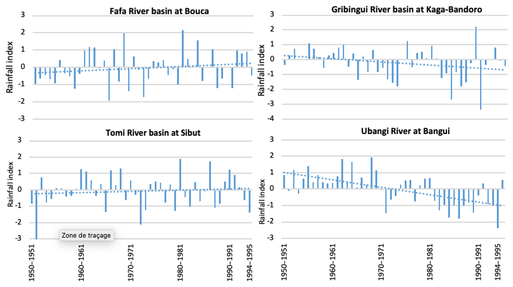
Figure 2Rainfall index from 1950 to 1995 for 3 studied basins and the Ubangi basin at Bangui.
Table 1Years of ruptures detected in rainfall time series per basin.

The period ratio is the rainfall amount of one period divided by the interannual rainfall average.
The analysis of ruptures confirms that the major climatic rupture measured on the larger basin such as Ubangi is not high on these 3 basins, even absent on the Tomi basin (Table 1). The break of the large drought recorded in West and Central Africa, marked in 1968 on the Ubangui Basin, is only recorded on the Fafa basin. The Pettitt's test and the Bayesian method have given identical breaks dates in the Gribingui (in 1982) and the Fafa (in 1969) basins, which diverge with those obtained by Hubert's segmentation. According to the Hubert's segmentation, the Gribingui basin has known two ruptures (1989, 1990) with two rainfall homogeneous periods: 1314 mm in 1951–1989, 694 mm in 1990–1990, and 1367 mm in 1991–1995. In fact, the 1990 break shows an unique year dropped. To resume, only the Fafa basin, located between those of Gribingui in the North and Tomi in the South, has recorded a real rainfall rupture in 1968, with homogeneous periods, +6 % over the wet period (1951–1968) and −3 % over the dry period (1969–1994). But on Ubangi basin, there are two homogeneous dry periods since 1968: less dry on 1969–1980 (−1 %) and dry (1981–1994) over this 1950–1995 period (Table 1). Although a comparison is done between the 3 basins' trend and the Ubangi's one, its largest size basin (499 000 km2) subjected to the high spatial heterogeneity leading to its rainfall distribution and reduction. Due to the 3 basins small size (from 2000 to 6000 km2), the diversity of observed ruptures is probably directly linked to their basin characteristics. The particularity of Tomi basin which does not record any rupture could be justified by the geographical features (smallest and steeper basin, density of vegetation, drained nodular soils) showing alternated short wet and dry rainfall trend over time.
3.2 Discharges and ruptures of stationarity of the studied basins
The interannual mean discharge on 1950–1995 period is, from North to South, 22 m3 s−1 for Gribingui, 37 m3 s−1 for Fafa and 18 m3 s−1 for Tomi, with respectively specific discharge 3.9, 8.4, and 7.6 L s−1 km−2. The Gribingui basin is twice drier than Fafa and Tomi basins. Such as the rainfall pattern, the discharge evolution of Gribingui is quite equivalent to that recorded on the Ubangi at Bangui. At the opposite, the discharge evolution of Tomi didn't show any marked drought period: just a weak humid period from 1961 to 1970, then a high peak of discharges corresponding to heavy rains during 3 consecutive years (1991, 1992, 1993) (Fig. 2), with important flood events. Indeed, the 1990s is marked by a rainfall recovery observed on Fafa and Tomi basins, which was not recorded in the Ubangi River basin. The discharge evolution in the Fafa basin is a balance between the Gribingui and Tomi basins. There is a humid period before the 1970s and a peak discharge from 1991 to 1993 due to short rainfall recovery at this time (Fig. 3).

Table 2Years of ruptures detected in hydrological time series per basin.
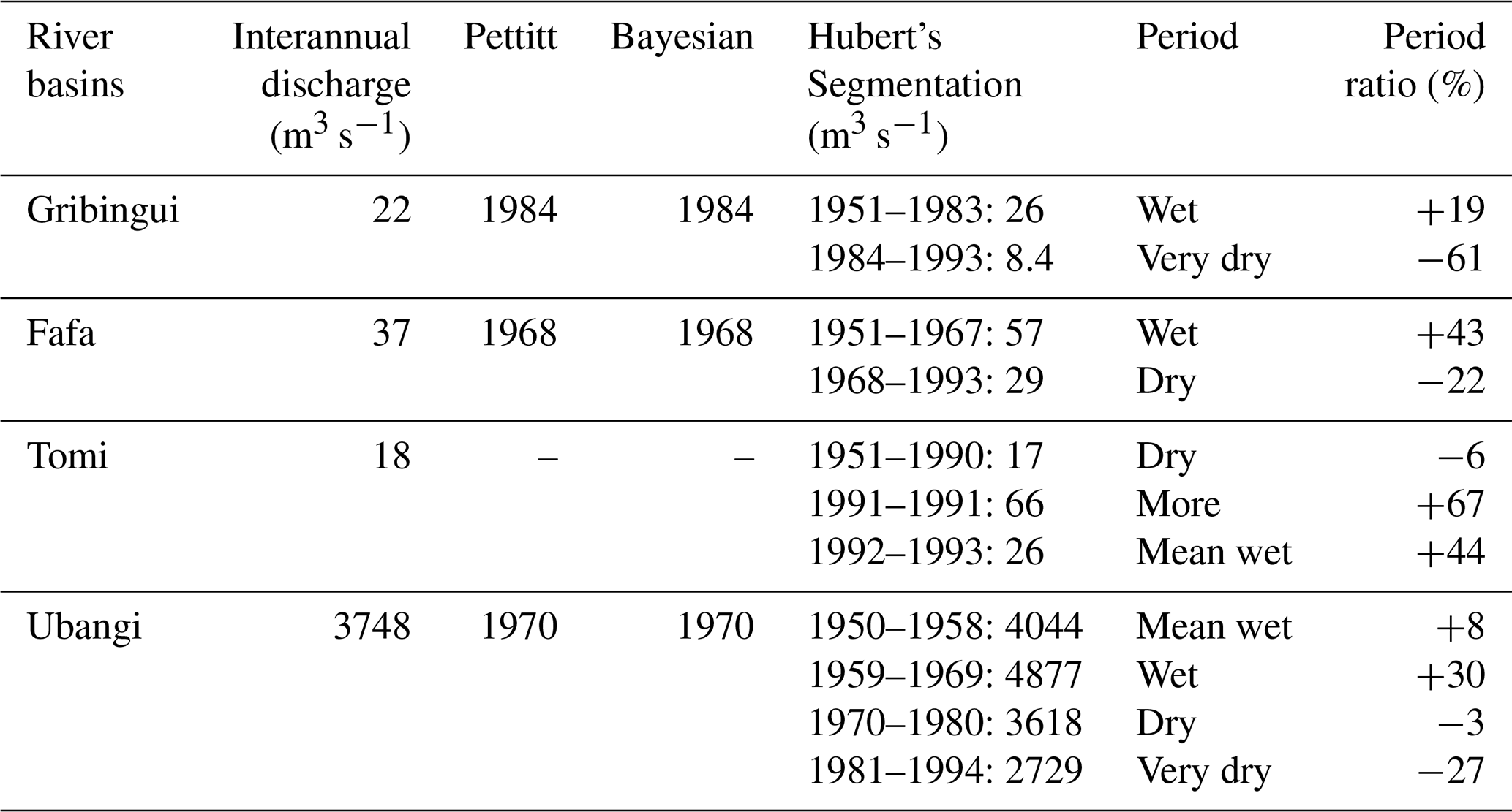
The period ratio is the discharge amount of one period divided by the interannual discharge average.
The rupture tests over the hydrological series (Table 2) are varied to results found on rainfall series: one rupture for Tomi in 1990/1991, one break only for Gribingui in 1984 (2 years after the rainfall rupture) and a severe rupture for Fafa in 1968, and mainly three ruptures (1958, 1969 and 1980) for Ubangi (Table 1).
3.3 Dynamics of the depletion coefficient
In the 3 studied basins, there are the same range of the depletion coefficient than for the Ubangi at Bangui (Nguimalet and Orange, 2019), from 0.010 to 0.035 d−1 over the studied period. Maxima are of 0.035 d−1 in 1987 and 1989 over Tomi, 0.030 d−1 in 1989 over Gribingui, 0.032 d−1 in 1988 over Fafa and 0.025 d−1 in 2000 over Ubangi (Fig. 4). These maxima are all recorded in the 1990's period. And all the minima are situated around the year 1970: 0.08 d−1 in 1973 on Gribingui, 0.010 d−1 in 1968 on Fafa, and 0.015 d−1 in 1970 on Tomi. On the Ubangi, the minimum was of 0.013 d−1 in 1953. These figures show a critical evolution of the groundwater contribution to the discharge: from 0.054 km3 in 1987 to 0.4 km3 in 1991 on Tomi, from 0.095 km3 in 1987 to 0.24 km3 in 1992 on Gribingui, from 0.071 km3 in 1987 to 0.5 km3 in 1994 on Fafa, and from 55 km3 in 1974 to 21 km3 in 1990 on Ubangi. Though the 1970 rupture is not so severe, and even not visible over the Tomi basin, the total potential groundwater per catchment seems to diminish significantly everywhere during the most recent studied years. Fafa and Gribingui described the same image as Ubangi for both the evolution of depletion coefficient and total potential groundwater, each time around of 1970 (Fig. 4). Due to this global trend, groundwater level increases since the 1988 severe drought benefiting of the short rainfall recovery for Fafa, Tomi and also for Ubangi while it decreases for Gribingui.
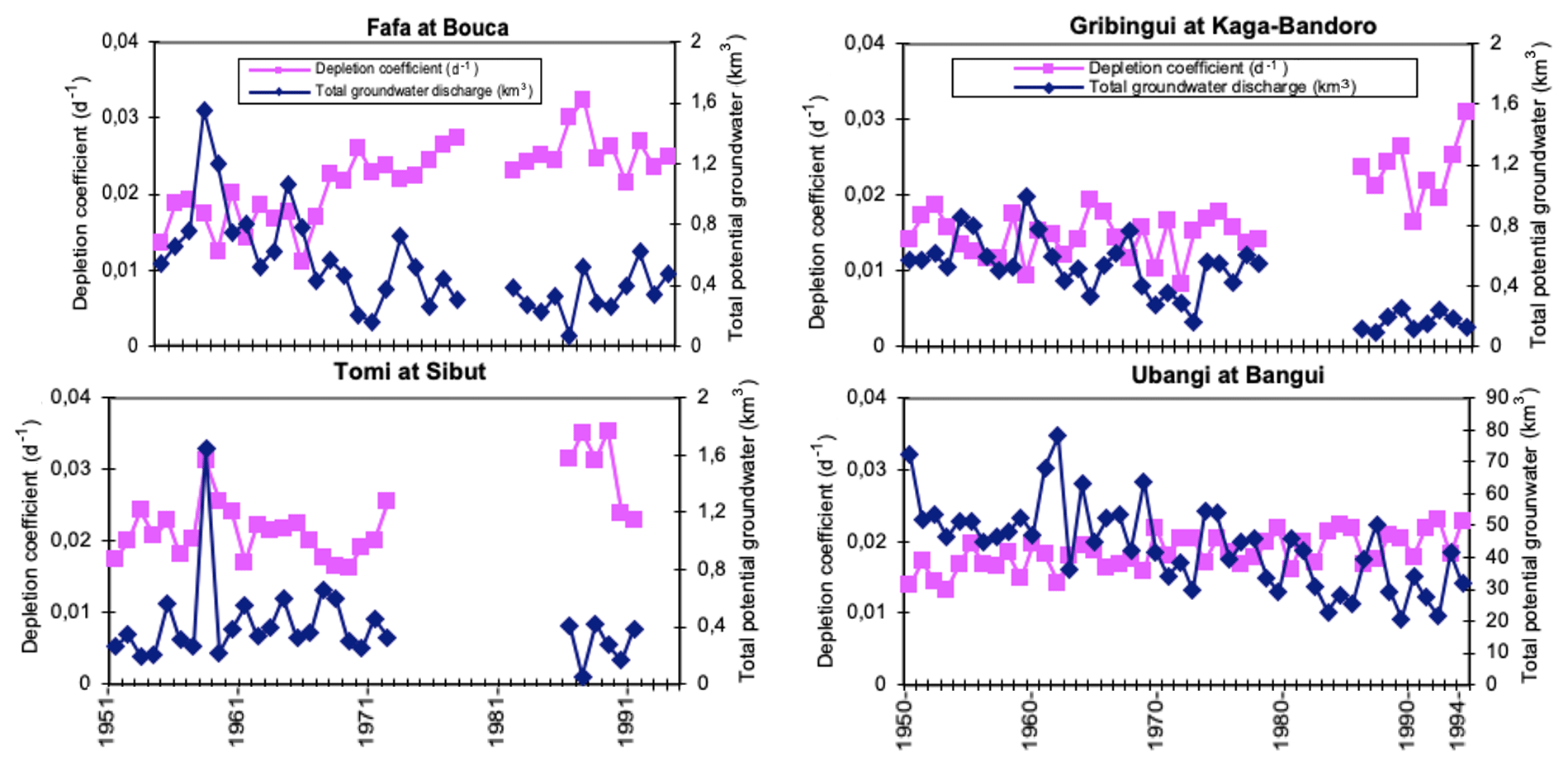
Figure 4Interannual evolution of depletion coefficient and total potential groundwater discharge (1950–1995).
Nowadays, the anthropization of the 3 studied basins is still weak, not only because of weak human densities (6.24 inhabitants km−2), but also because of the extensive agriculture practices. Then this weak human impact on the environment cannot drive any pressure on the hydrological regimes of these basins. The evolution of the rainfall-discharge relationship from 1950 to 1995 is quite similar inside each small studied basin, but they are not comparable between each basin. First it is noticeable that the great drought recorded within all the large rivers from West and Central Africa has been recorded only on Fafa basin that flows towards Lake Chad. On this basin, the drought period started in 1968 as recorded on the Ubangi river at Bangui, with successive drops (−3 % and −27 % respectively). It is the case of the Pipi basin at Ouadda in the NE of the Ubangi basin, where the drought begins in 1968 (Nguimalet and Ndjendolé, 2008). Besides, there is an absence of rainfall rupture in the Tomi basin meanwhile the discharge rupture occurred in 1990. That would be due both to its smallest size (2380 km2) and to its nodular soils and forested vegetation towards its common sources with Fafa. For both, the importance of vegetation cover and respective soils play a main role into rainy processes. In addition, the singular behavior of Tomi would come from its high elevation's difference (0.0024 m m−1), compared to Gribingui (0.0014 m m−1) and Fafa (0.0011 m m−1). A reverse situation is observed in the Gribingui basin with both a rupture year for rainfall in 1989 against only one for the annual mean discharge serial data. The diversity of these results is probably linked to the hydrological abundance of each basin. On the driest northwards, Gribingui with a specific discharge of half the two other studied basins, the river discharge is not really impacted by the drought of the 1970s but only the recent drought on 1988 recorded on the 3 rivers is marked, even on Ubangi river. The regime of Tomi is quite stable, consequence of a homogeneous rainfall pattern from 1950 and probably due also to a good groundwater contribution, marked by a specific discharge over 7 L s−1 km−2 and a smooth evolution of the depletion coefficient due to its basin' geographical features (Fig. 4). The Fafa basin shows an intermediate behavior between Gribingui in the North and Tomi in the South. Then it seems that a drought effect into these catchments is more marked according to a South-North gradient through ruptures on rainfall and discharge regimes at different dates. Conway et al. (2009) also noticed that Eastern Africa's rivers have known the hydrological degradation later during the 1980s, when the drought was extensively recorded in many areas over subSaharan Africa. As for rainfall regimes modifications, Kouassi et al. (2018) talked about “late break ” observed in 1980s, compared to “earliest” that occurred in the late 1960s. Thus one supposes that variable “size of basin” would intervene according to brutality/ spontaneity (in case of Tomi) of flow regime under the effect of slope (basins of small size) or of delayed and differed response of basin to rainy events.
However, the groundwater time series are more impacted than the discharge ones. On the Tomi and the Fafa basins, the depletion coefficient and the total potential groundwater discharge have a similar evolution than that of the Ubangi basin at Bangui since the end of 1980s, mainly in 1988s. Only the basin of Gribingui at Kaga-Bandoro shows a weak decrease of the groundwater potential from early 1990s.
This research of ruptures on the rainfall and discharge long serial data on 3 small close basins (from 2000 to 6000 km2) of Central Africa north of the Equator, has shown a high variability over the period 1950 to 1995. The continental rupture of 1970 marking the beginning of the drought in West and Central Africa is not clearly observed. Each basin displays the specificity of its hydroclimatic functioning. Then it is difficult to compare the hydroclimatic periods from one basin to another one. However, all the studied basins have shown a degradation of their hydrological regimes since the end of the 1980s due to the drought severity. That is confirmed by Mahé (1995) that the 1981–1989 period is dry, mainly in the North (Ubangi) at the interface of Chad and Congo basins where located the 3 studied basins. The potential of groundwater discharge has decreased on the 3 studied basins, with a minimum level around 1988 for each basin. Nevertheless, it seems to increase in the 3 basins with a rainfall recovery noted at the 1990s starting.
This study has demonstrated that even if the discharge evolution is not really marked by the drought of 1970, all the studied basins are nowadays under water stress with their potential groundwater discharge at the weakest state.
The original data are available online at https://www.researchgate.net/publication/343111160_RCA_Tomi_Gribingui_Fafa_Data#fullTextFileContent (Orange, 2020).
Both authors contributed equally to this work.
The authors declare that they have no conflict of interest.
This article is part of the special issue “Hydrological processes and water security in a changing world”. It is a result of the 8th Global FRIEND–Water Conference: Hydrological Processes and Water Security in a Changing World, Beijing, China, 6–9 November 2018.
The authors acknowledge the FRIEND–Water network for the opportunity to publish these original data. Special thanks for the anonymous reviewers.
Ardoin-Bardin, S., Dezetter, A., Servat, E., Paturel, J. E., Mahé, G., Niel, H., and Dieulin, C.: Using general circulation model outputs to assess impacts of climate change on runoff for large hydrological catchments in West Africa, Hydrolog. Sci. J., 54, 77–89, 2009.
Conway, D. P., Persechino, A., Ardoin-Bardin, S., Hamandawana, H., Dieulin, C., and Mahé, G.: Rainfall and river flow variability in sub-Saharan Africa during the 20th century, J. Hydrometeorol., 10, 41–59, 2009.
Fadika, V., Goula, B. T. A., Kouassi, F. W., Doumouya, I., Koffi, K., Kagamate, B., Savane, I., and Srohorou, B.: Variabilité interannuelle et saisonnière de l'écoulement de quatre cours d'eau de l'Ouest côtier de la Côte d'Ivoire (Tabo, Dodo, Néro, San Pédro) dans un contexte de baisse de la pluviométrie en Afrique de l'Ouest, Eur. J. Sci. Res., 21, 406–418, 2008.
Goula, B. T. A., Savané, I., Konan, B., Fadika, V., and Kouadio, G. B.: Impact de la variabilité climatique sur les ressources hydriques des bassins de N'Zo et N'Zi en C. I. (Afrique tropicale humide), VertigO, 7, 1–12, 2006.
Kouassi, K. M., Kouassi, K. L., Lorougnon, G. D. J., Yao, K. B., Mélédjé, N. H., Biemi, J., Lasm, T., and Rouché, N.: Variabilité des extrêmes pluviométriques sur le bassin versant de la rivière Bia (Sud-Est, Cote d'Ivoire), Eur. J. Sci. Res., 14, 134–147, 2018.
Laraque, A., Olivry, J. C., Orange, D., and Marieu, B.: Variations spatio-temporelles des régimes pluviométriques et hydrologiques en Afrique Centrale du début du siècle à nos jours, FRIEND '97 – Regional Hydrology: Concepts and Models for Sustainable Water Resource Management, IAHS Publ., 246, 257–263, 1997.
Laraque, A., Mahé, G., Orange, D., and Marieu, B.: Spatiotemporal variations in hydrological regimes within Central Africa during the twentieth century, J. Hydrol., 245, 104–117, 2001.
Lubes-Niel, H., Masson, J. M., Paturel, J. E., and Servat, E.: Variabilité climatique et statistiques. Étude par simulation de la puissance et de la robustesse de quelques tests utilisés pour vérifier l'homogénéité de chroniques, Rev. Sci. Eau, 11, 383–408, 1998.
Mahé, G.: Modulation annuelle et fluctuations interannuelles des précipitations sur le bassin-versant du Congo, in: Actes du Colloque PEGI Grands Bassins Fluviaux Péri-Atlantiques: Congo, Niger, Amazonem edited by: Boulègue, J. and Olivry, J. C., INSU, CNRS, ORSTOM, Paris, France, 13–26, 1995.
Nguimalet, C. R.: Climate change analysis across rainfall-discharge variability in selected river catchments of Kenya and Central African Republic, Palaeoecol, Afr,, 32, 195–220, 2013.
Nguimalet, C. R.: Comparison of community-based adaptation strategies for droughts and floods in Kenya and the CAR, Water International, 43, 183–204, 2018.
Nguimalet, C. R. and Ndjendolé, S.: Les extrêmes hydrologiques: des indicateurs d'hydrodynamisme ou d'hydraulicité du plateau gréseux de Mouka-Ouadda sur la rivière Pipi à Ouadda (République Centrafricaine), Z. Geomorphol., 52, 125–141, 2008.
Nguimalet, C. R. and Orange, D.: Dynamique hydrologique récente de l'Oubangui à Bangui (Centrafrique): impacts anthropiques ou climatiques?, Geo-Eco-Trop, 37, 101–112, 2013.
Nguimalet, C. R. and Orange, D.: Caractérisation de la baisse hydrologique actuelle de la rivière Oubangui à Bangui, République Centrafricaine, Houille Blanche, 1, 78–84, 2019.
Olivry, J. C., Briquet, J. P., and Mahé, G.: Variabilité de la puissance des crues des grands cours d'eau d'Afrique intertropicale et incidence de la baisse des écoulements de base au cours des deux dernières décennies, Water Resources Variability in Africa during the XXth Century, IAHS Publ, 252, 189–197, 1998.
Orange, D.: RCA_Tomi Gribingui Fafa Data, ResearchGate, available at: https://www.researchgate.net/publication/343111160_RCA_Tomi_Gribingui_Fafa_Data#fullTextFileContent, last access: 21 July 2020.
Orange, D., Wesselink, A. J., Mahé, G., and Feizouré, C. T.: The effects of climate changes on river baseflow and aquifer storage in Central Africa. In: Sustainability of water resources under increasing uncertainty, IAHS Publ, 240, 113–123, 1997.
Wesselink, A., Orange, D., Feizoure, C., and Randriamiarisoa: Les régimes hydroclimatiques et hydrologiques d'un bassin-versant de type tropical humide: l'Oubangui (République Centrafricaine), in: L'Hydrologie Tropicale: géoscience et outil pour le développement, IAHS Publ, 238, 179–194, 1996.