the Creative Commons Attribution 4.0 License.
the Creative Commons Attribution 4.0 License.
 | 16 Sep 2020
Analysis of water level variations in the Huangzhuang reach (Hanjiang River, China) during recent years
Xiao Xiao
Beiping Mao
Bao Qian
The 2017 Hanjiang autumn flood appeared to have higher surface water levels at the same discharge rate than previously at the Huangzhuang gauging station. It is seriously impacted the flood control. This paper analyses the 2000–2017 data from the Huangzhuang reach in the Hanjiang River, including surface water levels, the surface water fall, erosion-deposition variation and the engineering activities. A comparison of the 2016–2017 data with the 2000–2015 data in the Huangzhuang reach, revealed that the surface water levels were about 1.47 and 0.13 m higher in the high and intermediate discharge ranges, respectively. In the low discharge range, the 2016–2017 and 2010–2015 surface water levels were similar. However, a comparison of the 2016–2017 with the 2000–2009 data in the low discharge range, shows that the surface water levels were 0.28–0.4 m lower. The surface water fall in the Zhuandouwan–Huangzhuang's reach decreased in 2016–2017 for discharges above 5000 m3 s−1, whereas in the Huangzhuang–Datong reach the opposite was found. For other time periods and discharge ranges the fall decreased. In the Datong-Shayang reach the fall reduced in 2014–2015 relative to other periods in 2000–2017 in the discharge range above 5000 m3 s−1. The erosion-silting analysis for the Huangzhuang reach showed scouring of local river deposits due to bridge engineering. However, near the bridge the substantial silting was found. The collated surface water level and scouring-silting data suggest that reduced surface water levels during low discharge are mainly due to the overall river erosion. The increased surface levels in the high discharge range are due to local river siltation, especially because of the increased water resistance as response to bridge engineering.
- Article
(716 KB) - Full-text XML
-
Supplement
(188 KB) - BibTeX
- EndNote


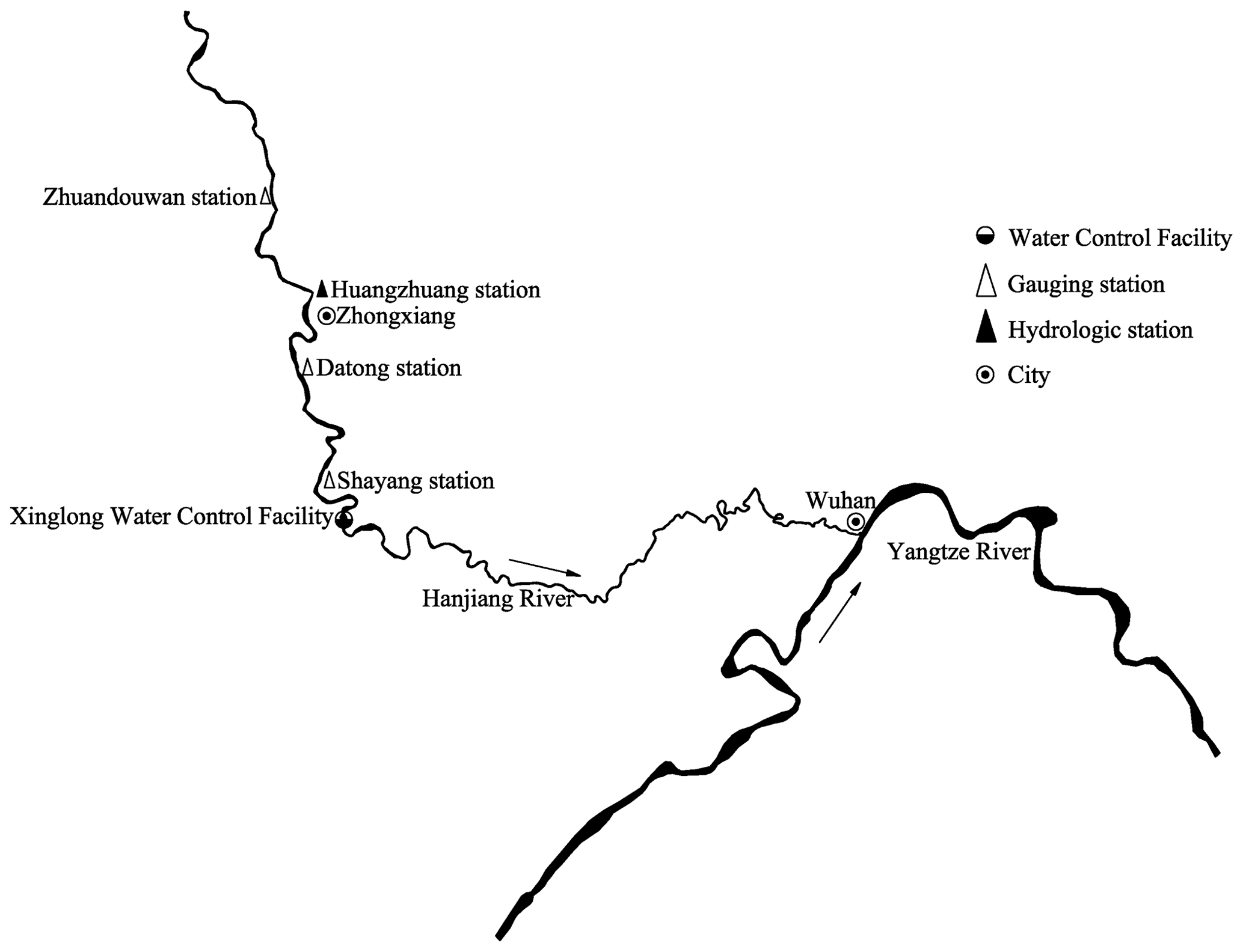
Figure 1Sketch map of the research river.
The Hanjiang River is a large tributary of the Yangtze River and has its confluence near Wuhan (China). The Hanjiang River is divided into the upper, middle and lower reaches (Zhang et al., 2004). The Huangzhuang reach is at the middle and lower reaches of the Hanjiang River, which is a critical part to prevent floods. Hence, its flood characteristics are important. The climate, including precipitation characteristics of the Hanjiang River basin lead to a distinct difference in flooding hazard between summer and autumn (Sun et al., 2014; Dai et al., 2012). Li et al. (2017) concluded that the autumn flood of the Hanjiang River in 2017 was mainly characterized by a long duration and frequent occurrence of floods. The flood peak was not so high, but the flood volume was big. The river water level rose significantly at the middle and lower reaches. Xia et al. (2006) analyzed the flood characteristics of the autumn flood of the Hanjiang River in 2005, which was also was characterized by a large flood volume, but this had a high flood peak. Wu and Guan (2017) and Duan et al. (2018) have studied the flood control and regulation scheme for the middle and lower reaches of the Hanjiang River. Besides analyzing floods in the Hanjiang River, many scholars have also researched the water level characteristics of the Hanjiang River. For example, Lu et al. (2009) and Shi et al. (2013) have studied the impact of the building of the Danjiangkou Reservoir, which is in the upper reach, on the discharge characteristics of the Hanjiang River. Wang et al. (2017) have studied the hydrological characteristics of the lower reach, and Feng et al. (2016) have analyzed the impact of discharge variation on the state of the middle and lower reaches of the Hanjiang River.
The Huangzhuang hydrologic station is the main control station at the Huangzhuang reach of the Hanjiang River. About 32 km downstream the Datong gauging station can be found. During the autumn flood of the Han River in 2017, the actual hydrological measurements indicate that the observed water level of the Huangzhuang station was a bit high for the discharge at that time. To further understand the change in surface water level pattern of the Huangzhuang reach and the underlying reasons, this paper will study the relationship of the surface water level and discharge, and find out the changing pattern of water level at the Huangzhuang station. We will use data from the period 2000–2017, such as the highest water level, lowest level and corresponding discharges in these years. Data from four stations are analyzed, namely, from upstream to downstream, the Zhuandouwan station, Huangzhuang station, Datong station and Shayang station. Three important time moments are considered, namely, 2009 (when the Xinglong Water Control Project commenced to be constructed), 2013 (when the Xinglong Water Control Project was completed), and 2016 (when the Highway No. 2 bridge over the Hanjiang River at Zhongxiang commenced to be constructed). The following time sections were identified: 2005–2008, 2009–2013, 2014–2015 and 2016–2017, which were associated with average discharges of below 1000, 1000–5000, 5000–10 000 and 10 000 m3 s−1. The scour and silting changes within the Nianpanshan-Maliang reach (68.9 km) were analyzed based on data from 31 fixed large cross sections in the period between 2012 and 2016. Finally, the impact of the Highway No. 2 bridge project, which included damming near the bridge, on the water level of the Huangzhuang reach was analyzed according to the changing relationship of water level and the discharge Han.
2.1 Water level changes at the Huangzhuang station
Relationships between the annual average daily highest water level (Fig. 2a), annual average daily lowest water level (Fig. 2b) and corresponding discharge at the Huangzhuang station between 2000 and 2017, revealed that at high discharges during 2016–2017 (discharge: 13 000–17 000 m3 s−1), the water level was about 1.47 m higher than that during 2000–2015. At intermediate discharges (2000–10 000 m3 s−1), the water level was about 0.13 m higher. At low discharges (less than 3000 m3 s−1), the water level was similar to the level during 2010–2015, whereas the water level was 0.28–0.41 m lower than during 2000–2009. So, for the same discharge, the water level at the Huangzhuang station witnessed a significant rise in the high flows range in recent years. The change mainly happened after 2016. For the low flow range the opposite was found, although change is smaller.
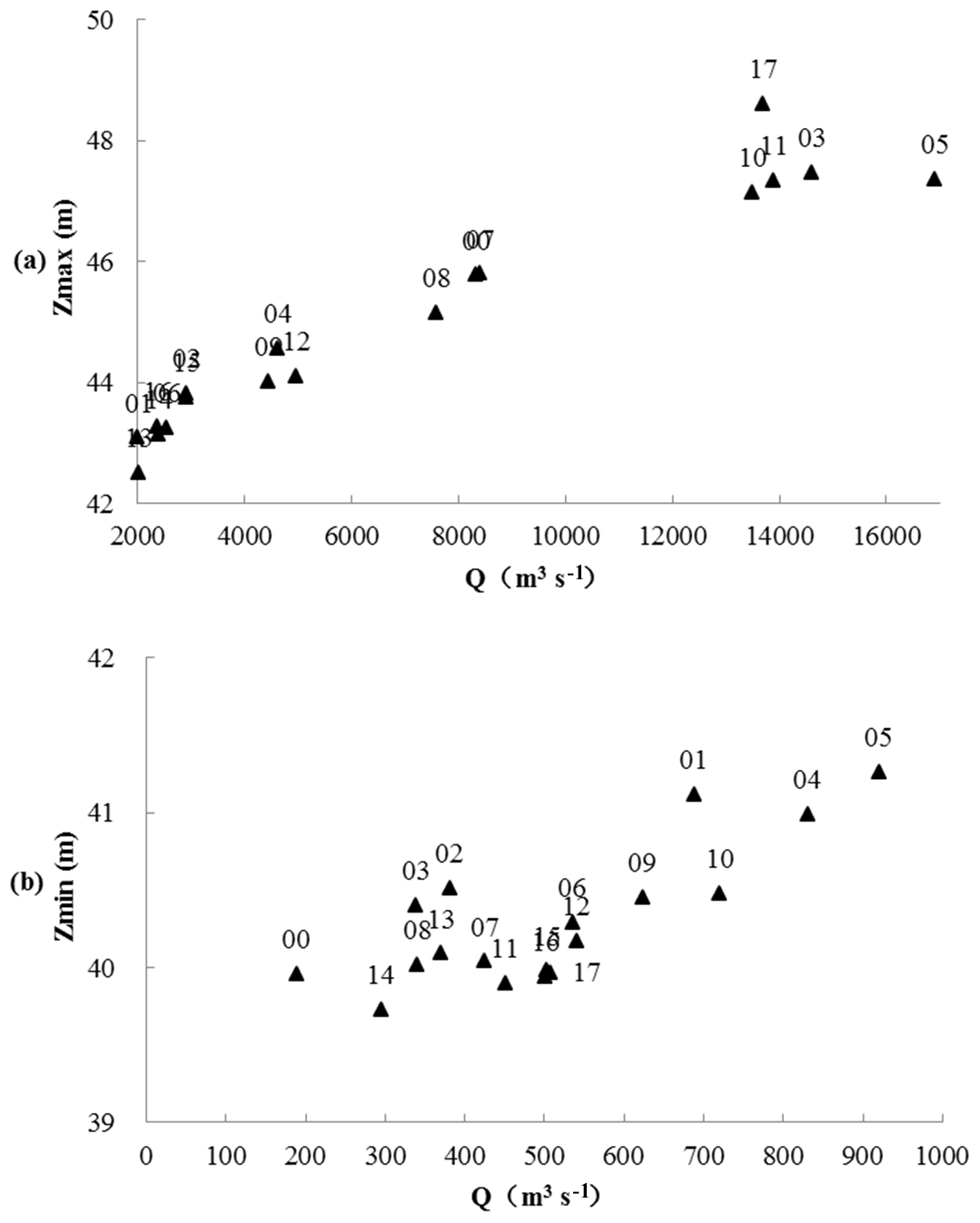
Figure 2Relationship between annual average daily water levels and corresponding discharge at the Huangzhuang station for the period 2000–2017, (a) maximum water level, and (b) minimum water level. The numbers refer to the years, e.g. 00 means 2000.
2.2 Analysis of Huangzhuang reach surface fall
The distances between the Zhuandouwan and Huangzhuang stations, Huangzhuang and Datong stations, and Datong station and Shayang stations is 22, 32 and 39 km, respectively. The surface water fall (decrease of surface water level over reach) for different discharge ranges and the defined time periods is shown in Fig. 3. The surface water fall (decrease of surface water level over reach) was calculated for each time period and discharge range as the average of all daily falls. Figure 3 indicates that the surface water fall in the Zhuandouwan-Huangzhuang reach shows a decreased fall in the two most recent periods (Fig. 3a). The surface water fall in the Huangzhuang-Datong reach during 2016–2017 witnessed a big increase when the discharge was above 5000 m3 s−1, while the opposite was found for the time sections 2005–2008 and 2009–2013 (Fig. 3b). The surface water fall of Datong-Shayang reach during 2014–2015 witnessed a big drop (only available when the discharge was lower than 5000 m3 s−1). The Datong-Shayang reach was affected by the Xinglong Water Control facility, while the Huangzhuang-Datong reach was affected by related the project of bridges in the reach.
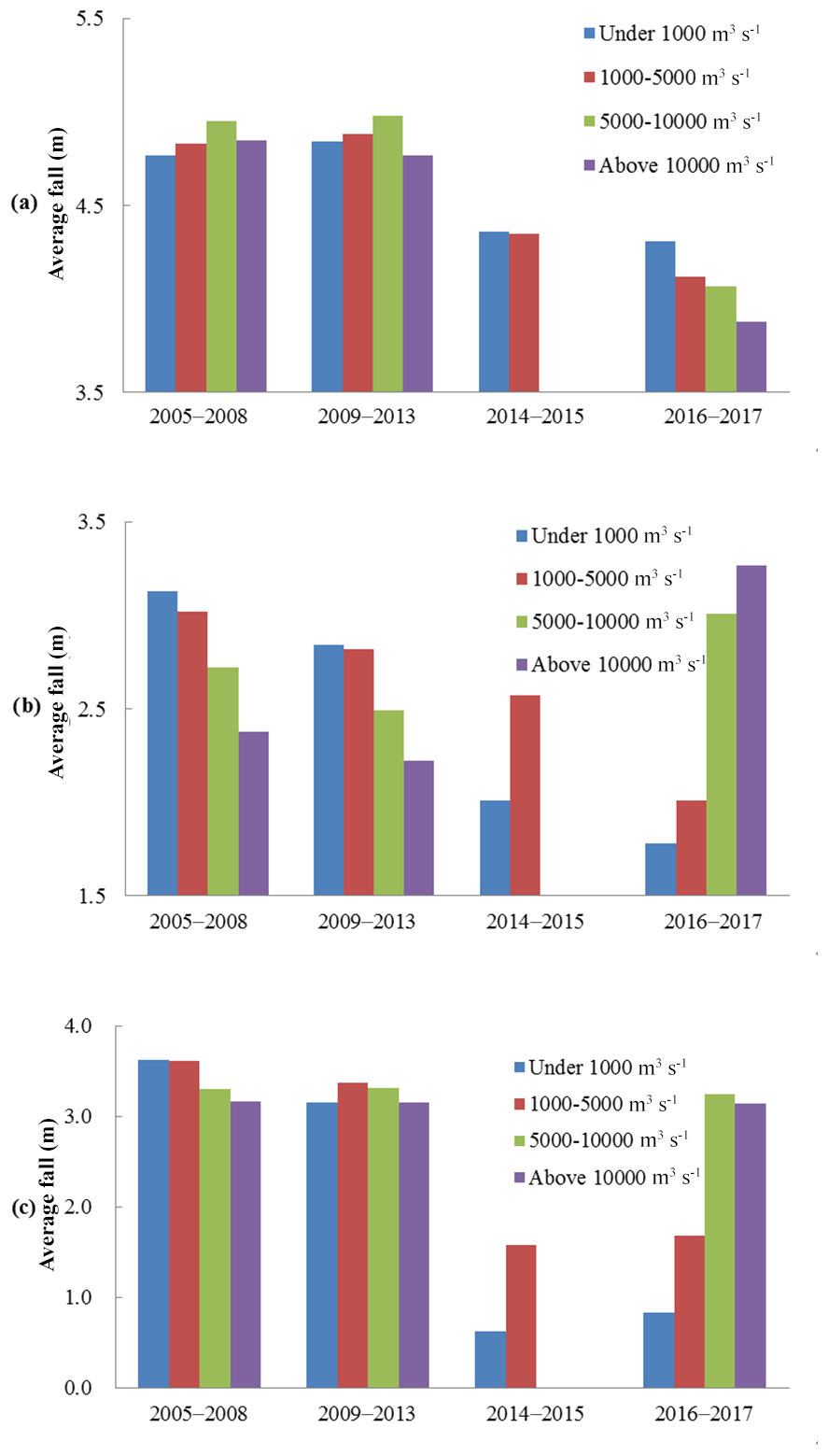
Figure 3Surface water fall in different reaches of the Hanjiang River for different discharge ranges and time periods in 2005–2017, (a) Zhuandouwan-Huangzhuang reach, (b) Huangzhuang-Datong reach, and (c) Datong-Shayang reach.
3.1 Analysis of scour and silting changes in the Huangzhuang reach
Scour and silting data were obtained from three measurements in the Nianpanshan-Maliang reach that were conducted in December 2012, December 2015 and December 2016. Channel storage and scour-silting in the reach was calculated with a cross-section method (Duan et al., 2001; Zhang et al., 1989; Wang et al., 2018). The scour-silting conditions of the reach since 2012 are shown in Table 1. During 2012–2016, the Nianpanshan-Maliang reach was a scour as a whole under different calculated water levels. From 2012 to 2015, 15.36 million m3 was scoured from the channel at high water levels. From 2015 to 2016, this number was 8.26 million m3 as a whole. When the channel was at a low water level, the reach scoured 2.57 million m3. during 2012–2015. Scouring is assumed to be an influencing factor for dropping of the water level.
Table 1Statistics of scour and silting amount in the Nianpanshan–Maliang reach riverbed (+silting, −scour).
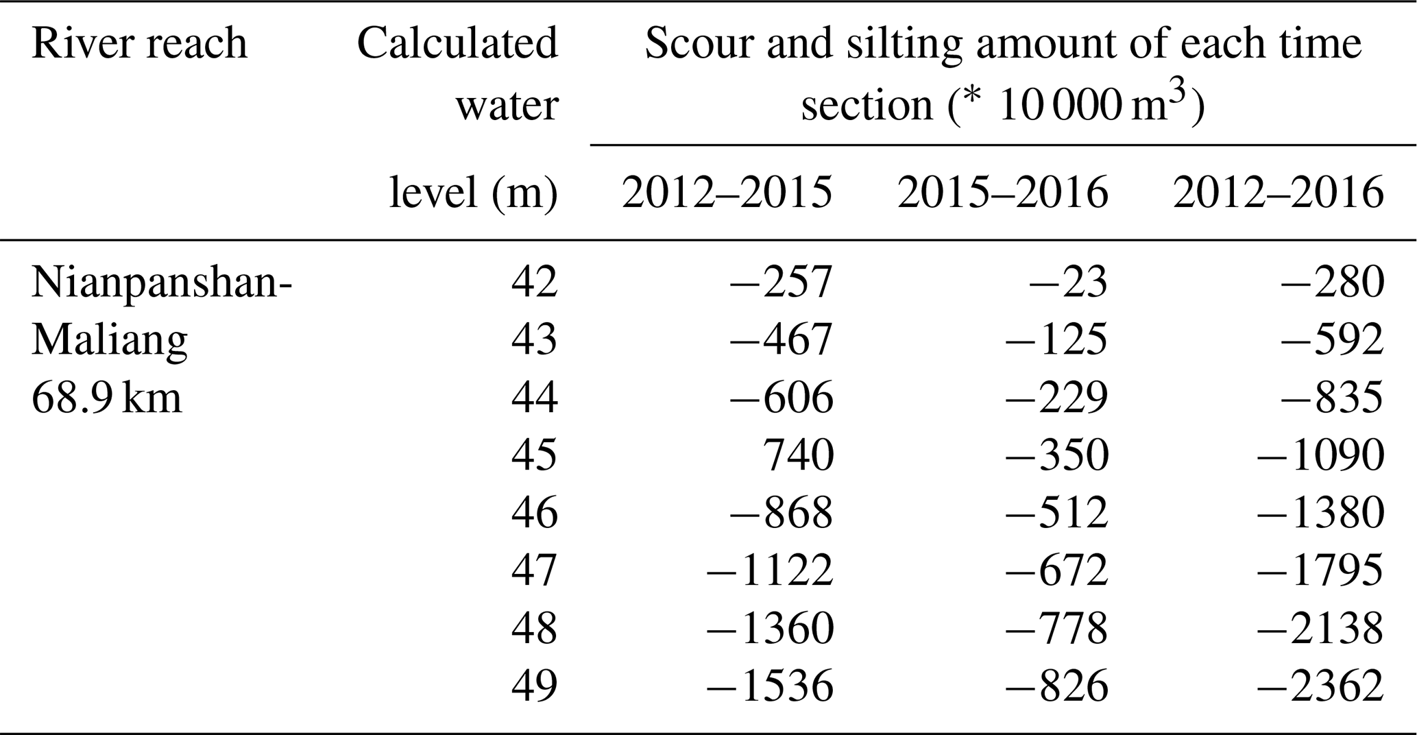
The calculated water level uses the national 85 elevation.
For further analysis, we investigated scouring and silting in the Hanjiang River in the reach from Huangzhuang to the Road No. 2 bridge Hanjiang Zhongxiang. This reach has a length of 8.1 km, in which 4 fixed large cross-sections occur. The reach showed scouring between 2012 and 2015 (Table 2). The opposite holds for water levels of 42–46 m in the period 2015–2016. In this period the reach showed silting. Partial silting of this reach may be the cause for the rising of the Hanjiang River at Huangzhuang at a high water levels. However, the influence was not distinct.
Table 2Statistics of scour and silting amount in the Huangzhuang–Zhongxiang reach riverbed (+silting, −scour).
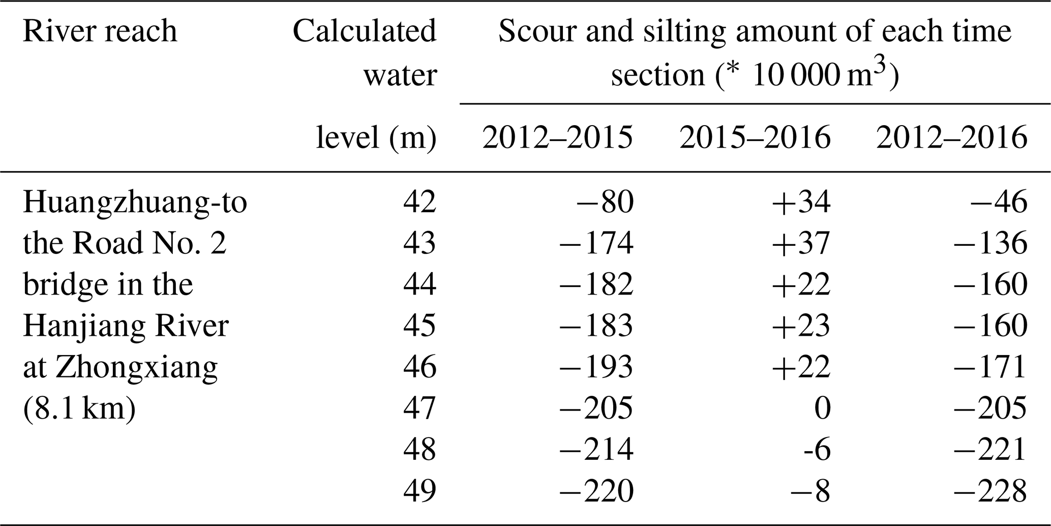
The calculated water level uses the national 85 elevation base.
The Xinglong Water Control facility lies about 100 km downstream of the Huangzhuang station, which commenced to be constructed in 2009 and was completed in 2013. The water of the reservoir returned to the Hanjiang River about 70 km upstream of the Maliang station. The analysis of surface water levels and surface fall indicate that after the building of the Xinglong Water Control facility, the water level was higher when the discharge was less than 5000 m3 s−1 at the Shayang station. Meanwhile, the surface water fall in the Datong-Shayang dropped. Compared to other stations, impact on water level and surface fall here was small.
From 2013 to 2016, many spur dikes, revetments, bottom protection measures, channel filling and beach protection belts have been built within the reach from Nianpanshan to the Xinglong Water Control facility. They were intended to regulate the channel, with the aim to deepen the main river channel. The elevation of the jetty head of the spur dikes was about 41 m and the dike body was 2–3 m high, and around 5 m wide. They were densely placed in the upper and lower reaches of the Hanjiang River near Huangzhuang. Due to the water blocking effect of the dikes and the building of other projects, such as spur dikes and supporting revetments and bottom protection, the bottom roughness factor of river channels close to the structures was assumed to increase.
The analysis of surface water levels and surface water falls, showed that the channel regulation projects influenced the entire reach, but did not caused distinct changes.
During 2016–2017, the Road No. 2 bridge over the Hanjiang River at Zhongxiang was under construction. The bridge is located 9.7 km downstream the Huangzhuang station. The relationship between the surface water level and discharge, and the surface water fall near the bridge was measured. The changes in the relationship between the surface water level and discharge relative to the data from 2012 to 2016, shows that the road bridge caused a big impact(see also Sect. 3.2).
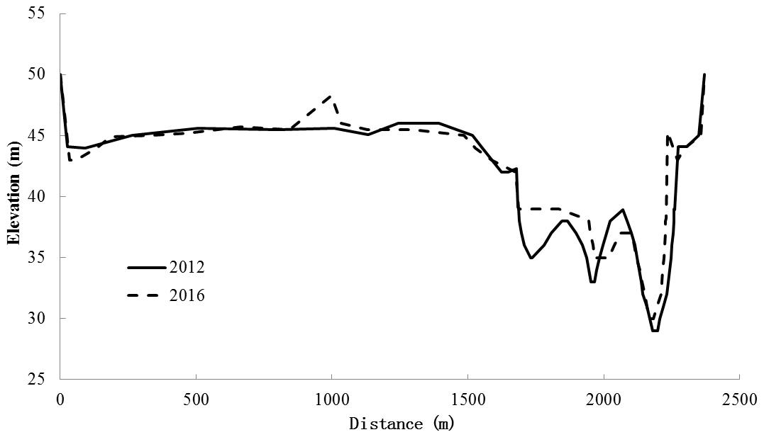
3.2 Changes of cross section at the bridge
Figure 4 shows the cross section at the bridge in 2012 and 2016. The figure shows that from 2012 to 2016, the silting on the left bank of the main river channel stretched over about 150 m, with a maximum silting thickness of 4 m. The silting line is about 20 m from the right bank of the main river channel, and the elevation of the lowest point of the riverbed rose from 29 to 30 m. The blocking area of the cofferdam during the construction period in 2016 was about 600 m2. The dam had an elevation of 39 m and a length of about 150 m on the left bank of the cross section. We estimate that the water blocking area of the three main piers was about 243 m2, and that the one of the pier on the bottomland was about 50 m2. It suggests that the water blocking during the construction was the main factor for the rising of the surface water level.
The Manning formula (Zhao et al., 2005) was used to calculate the stage-discharge relationship at for the conditions in 2012 and 2016 (Fig. 5). The following assumptions were made: (i) roughness factor of 0.03 based on the stage-discharge relationship of the Huangzhuang station, and (ii) gradient of 0.1 ‰ applicable to the Huangzhuang-Datong reach on 5 October 2017. The stage-discharge relationship indicates that when the water level was lower than 38 m, the curves of 2012 and 2016 basically coincide. When the water level was higher than 38 m, the surface water level in 2016 was higher than in 2012 for the same discharge, i.e. 0–1.3 m higher.
Table 3Observed surface water fall and gradient at the Road No. 2 bridge.

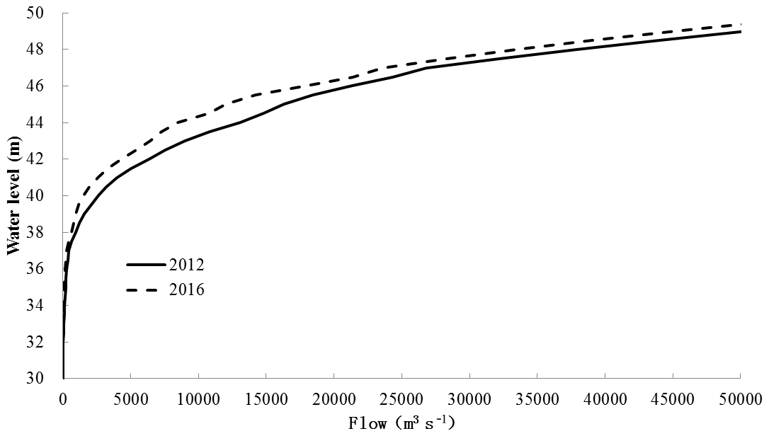
Figure 5Impact of construction work in 2016 on the stage-discharge relationship at the Road No. 2 road bridge over of the Hanjiang River in Zhongxiang.
3.3 Analysis of damming at the Road No. 2 bridge
The damming at Road No. 2 bridge over of the Hanjiang River in Zhongxiang is was analyzed using water level observations the upstream and downstream of the cross section of the bridge. Surface water levels were observed at 17:00–19:00 h on 6 October 2017. The positions of the observations points are shown in Figure 6 and the measuring results in Table 6. The measuring data show that the surface water fall is big, that is, 0.085, 0.143 m and 1296 m at 994 m, at upstream of the bridge, at the bridge, and at 1000 m downstream of the bridge, respectively. A small negative gradient has occurred at two places, both upstream and downstream of the bridge. On 6 October 2017, the average surface water fall over the Huangzhuang-Datong reach (32 km) was 2.94 m. The surface water fall over the reach from observation points 1# to 10# (3031 km) was 1621 m, accounting for 55.1 % of the entire surface fall from Huangzhuang to Datong. It indicates that the damming at the bridge is the main reason for the bit high surface water level at the Huangzhuang station.

Figure 6The measuring points at the Road No. 2 bridge.
-
Compared with 2000–2015, the surface water level at the Huangzhuang station was about 1.47 m higher in 2016–2017 in the high discharge range. In the middle discharge range, the water level was 0.13 m higher. The surface water level during 2016–2017 was basically similar with that during 2010–2015 in the low discharge range, but 0.28–0.41 m lower than in 2000–2009. The rise of the surface water level at the Huangzhuang station mainly occurred in the high discharge range predominantly after 2016. At the lower water level, the water level showed a trend of dropping.
-
The analysis of the changes in the surface water level and surface water fall, revealed that the water level of the Huangzhuang station during 2016–2017 mainly changed due to projects built in parts of the Huangzhuang-Datong reach. The building of the Xinglong Water Control facility mainly made the water levels of the Shayang station rise and the surface water fall of the Datong-Shayang station drop.
-
The Nianpanshan-Maliang reach of the Hanjiang River showed a trend of scouring as a whole. During 2012–2016, 2.80 million m3 was scoured in total from the reach. The overall scouring in the reach was the main reason for the drop of the surface water level in the low discharge range. Silting in the reach from Huangzhuang to the Road No. 2 bridge over Hanjiang River at Zhongxiang might have been a cause for the rising water level at Huangzhuang.
-
During 2012–2016, silting was observed in the cross section at the Road No. 2 bridge. When the water level exceeded 38 m, it was 0–1.3 m higher in 2016 than in 2012 under the same discharge. The surface water fall in the rather short subreach near the bridge was 1621 m, accounting for 55.1 % of the entire fall in the Huangzhuang-Datong reach (subreach is about 10 % of the whole reach) . The analysis reveals that the damming at the bridge was the main reason that the water level was a bit high in the high discharge range at the Huangzhuang station.
-
In summary, the main cause for the higher water levels at the Huangzhuang station were the impacts from projects in parts of the Huangzhuang-Datong reach, particularly the Road No. 2 bridge at Zhongxiang.
The data file will be sent separately to the editorial department.
The supplement related to this article is available online at: https://doi.org/10.5194/piahs-383-25-2020-supplement.
XX is responsible for data analysis and manuscript writing. Other authors participate in data collection and analysis.
The authors declare that they have no conflict of interest.
This article is part of the special issue “Hydrological processes and water security in a changing world”. It is a result of the 8th Global FRIEND-Water Conference: Hydrological Processes and Water Security in a Changing World, Beijing, China, 6–9 November 2018.
We would like to thank our colleagues from Middle Changjiang River Bureau of Hydrology and Water Resources Survey for their hard work.
This work is supported by the Hubei Provincial Natural Science Foundation of China under the contract no. 2017CFB312, the Fundamental Research Funds for the Central Universities (no. 2017B20514) and PAPD and the Open Foundation of State Key Laboratory of Hydrology-Water Resources and Hydraulic Engineering (no. 20174911111).
Changhong, W., Xiaobin, C., and Wangsheng, L.: Study on the hydrological characteristics of the lower reaches of Hanjiang River[J], China Water Transport, 17, 116–119, 2017.
Guangyin, F., Wenjie, L., and Lihua, Z., Dong, C.: Influence of flow process variation on river health in middle and lower reaches of Hanjiang River[J], Journal of China Hydrology, 36, 46–50, 2016.
Guobin, L., Yi, L., Xianglin, Z., Zhenghua, Z., and Tao, C.: Impact of the Danjiangkou reservoir on the flow regime in the middle and lower reaches of Hanjiang river[J], Resources and Environment in the Yangtze Basin, 18, 959–963, 2009.
Hongmei, M.: Analysis of river bed evolution and river regime control in the MANhekou to Shayang of Hanjiang River[D], The sixth session of the national river management and Ecological Restoration Technology Seminar, 114–119, 2014.
Jintai, Z.: Analysis of scouring and silting in Chenglingji to Hankou reach of Changjiang River[R], Bureau of Hydrology, Changjiang Water Resources Commission, 124 pp., 1989.
Linbo, W.: Han Jia Zhang Zi of raoyanhe hydrological characteristic water level for flood control (flow) study[J], Yangtze River, 49, 68–71, 2018.
Minglong, D., Lily, Y., and Yuanyuan, L.: Study on encounter rules of floods from Hanjiang River and upper Yangtze River[J], Yangtze River, 43, 48–51, 2012.
Wangchun, C., Jing, Z., Tao, Z., and Yubing, C.: Analysis of the storage capacity in the Shayang to Hankou reach of the downstream Hanjiang River[J], Express Water Resources & Hydropower Information, 38, 41–44, 2017.
Wei, X., Junya, M., Xianqun, Y., and Beiping, M.: Characteristics of flood peak discharge in the lower reaches of Hanjiang River in 2005[J], Yangtze River, 37, 28–34, 2006.
Weixin, D., Shenglian, G., Jun, Z., Wenhui, X., and Huanhuan, B.: Study on dynamic control scheme of water level of Danjiangkou Reservoir during flood season[J], Yangtze River, 49, 7–12 , 2018.
Wenzhong, D., Yahui, Z., and Jianjun, L.: Causes of water level rising in Chenglingji-Luoshan reach of Changjiang River[J], Journal of Hydraulic Engineering, 2, 29–34, 2001.
Xia, W. and Honglin, G.: Study on the flood control plan for Yicheng to Shayang section of middle and lower reaches of Hanjiang River[J], China Rural Water and Hydropower, 4, 35–40, 2017.
Xiaojun, Z., Jiaqing, H., and Huangyin, F.: Analysis of flood characteristics of middle reach of Hanjiang River[J], Journal of Changjiang Engineering Vocational College, 21, 6–7, 2004.
Xiurui, S., Xianlin, K., and Bin, Y.: Changes in the relationship between water level and discharge after Danjiangkou reservoir construction and its impact on downstream flood control[J], Express Water Resources and Hydropower Information, 20, 8–10, 1999.
Yunfa, L.: Recent scouring in the middle stream of Hanjiang River[J], Journal of Yangtze River Scientific Research Institute, 31, 1–5, 2015.
Yurong, L., Jun, Z., and Xiao, Z.: Autumnal flood analysis and forecast operation of Hanjiang River in 2017[J], Yangtze River, 48, 1–10, 2017.
Zhaohua, S., Qiufen, F., Jianqiao, H., and Qixin, C.: Reasons for heavy deposition of sandbar at confluence of Yangtze River and Han river during autumn flood season of 2011[J], Journal of Hydroelectric Engineering, 33, 111–117, 2014.
Zhenxing, Z. and Jianjing, H.: Hydraulic[D], Tsinghua University Press: Beijing, China, 458 pp., 2005.