Articles | Volume 382
https://doi.org/10.5194/piahs-382-843-2020
Pre-conference publication
 | 
27 Apr 2020
Pre-conference publication |  | 27 Apr 2020

Land subsidence and managed aquifer recharge in Pingtung Plain, Taiwan

Cheh-Shyh Ting, Kou-Feng Chiang, Sheng-Hsin Hsieh, Chi-Hung Tsao, Chi-Hung Chuang, and Kang-Teng Fan
Abstract

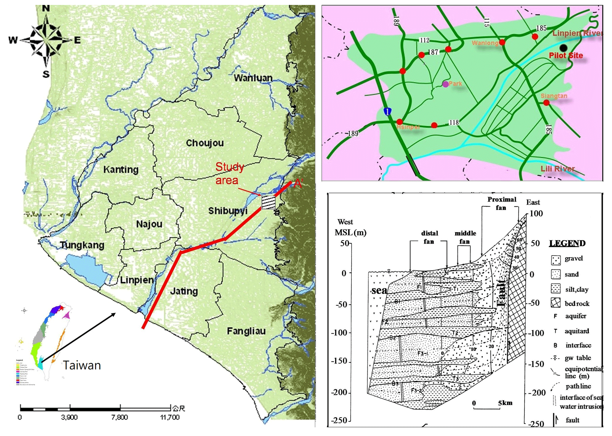
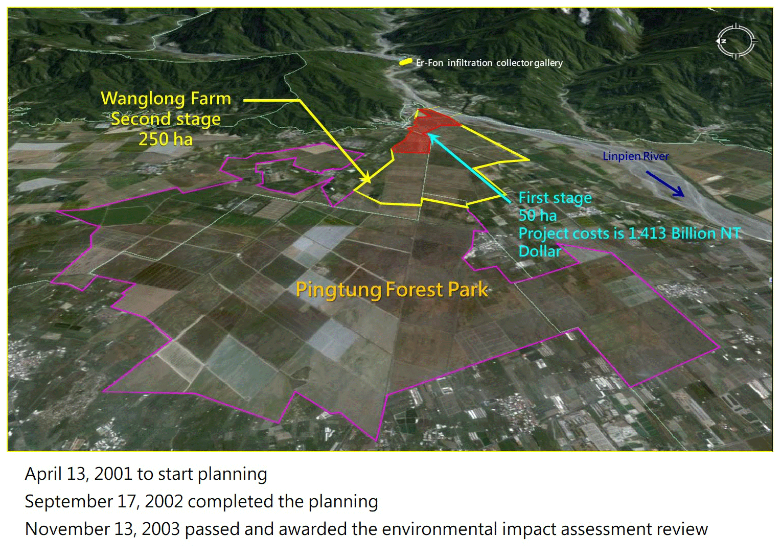
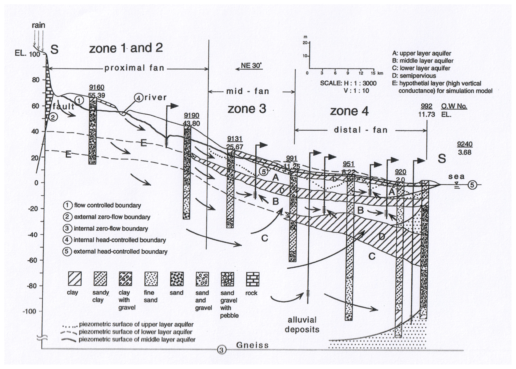
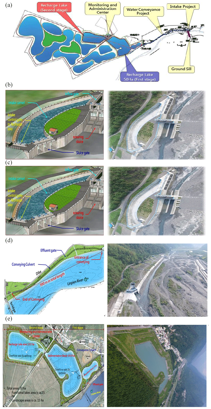
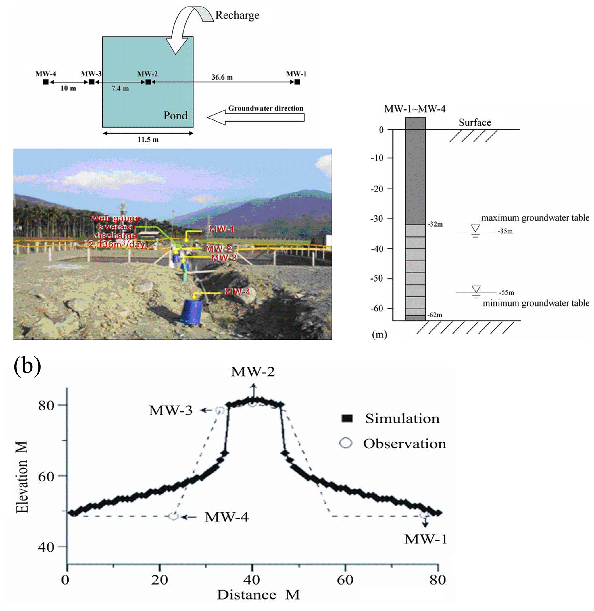
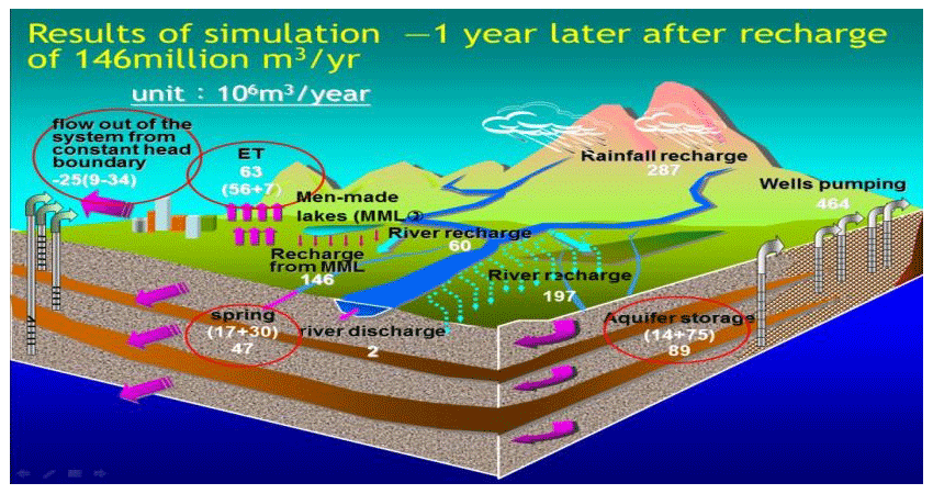
Taiwan is an oceanic nation with an area of approximately 36 000 km2. The Central Mountain Range was formed by the Eurasian and Philippine plates and stretches along the entire island from north to south, along the entire island, thus forming a natural line of demarcation for rivers on the eastern and western sides of the island. Pingtung Plain is formed by Quaternary alluvial fan material from the three main rivers. The aquifers comprise very coarse permeable sands and gravels under phreatic conditions in the north and less permeable sands under confined or even artesian conditions in the southern part of Pingtung Plain. The natural groundwater source is mainly from direct rainfall percolation and infiltration from the three main rivers, with their catchments lying partly outside the plain. The uncontrolled development of groundwater resources has led to undesirable effects, especially in the south, where aquaculture is concentrated. These effects are land subsidence, saline water intrusion, and lowering of water tables. It is thus one of the important key strategies in the solution of land subsidence, water resource development and flood control for sustainable development named Benefited Water Reuse from Storm Water in Pingtung, Taiwan. A serious of studies for this issue has been carried out. The feasibility study phase of the Artificial Recharge of Groundwater Project (ARGP) for Pingtung, Taiwan, was then implemented in 1997 using a MODFLOW simulation and an optimal model. Through the managed aquifer recharge model, the aquifer storage increases and the inundation scale decreases with land subsidence of the coastal area, as aimed at by the purpose of the controlled groundwater level. Infiltration mechanism simulation of artificial groundwater recharge, with the TOUGH2 model, was used to simulate the high infiltration behaviour in sequence in 2010. Both publications have been confirmed and approved by the Central Government and then approved by the environmental impact assessment. The ARGP was then implemented in May 2018 and operated for one wet season for the first phase with 50 ha and a total of 300 ha from May to October 2018. The sedimentation over the top of the recharge basin forms the clogging mechanism which has been analysed. The operation experience can further provide the mechanism process for research reference. The project, once implemented, can improve and mitigate land subsidence as well as formulate water banks for adapting and managing aquifer recharge.

1 Introduction

A series of studies for solving the land subsidence of coastal Taiwan and increasing water demand for multi-purpose issues has been carried out in Pingtung, southern Taiwan. The feasibility study phase of the Artificial Recharge of Groundwater Project (ARGP) for Pingtung, Taiwan, was then implemented in 1997 using a MODFLOW simulation and an optimal model. Through the managed aquifer recharge model, the aquifer storage increases and the inundation scale decreases at land subsidence of the coastal area as aimed at by the purpose of the controlled groundwater level. Infiltration mechanism simulation of artificial groundwater recharge, with the TOUGH2 model, was used to simulate the high infiltration behaviour in sequence in 2010. Both publications have been confirmed and approved by the Central Government and then approved by the environmental impact assessment. The ARGP was then implemented in May 2018 and operated for one wet season for the first phase with 50 ha of a total of 300 ha from May to October 2018. The sedimentation over the top of the recharge basin forms the clogging mechanism which has been analysed. The operation experience can further provide the mechanism process for research reference and improved suggestions. Figure 1 shows the location of the project area and hydrological profile of ARGP (NPUST, 2016).

https://www.proc-iahs.net/382/843/2020/piahs-382-843-2020-f01

Figure 1Location of the study area and hydrological profile in the study area (NPUST, 2016).

https://www.proc-iahs.net/382/843/2020/piahs-382-843-2020-f02

Figure 2Location map of the Artificial Recharge of Groundwater Project implemented in Pingtung, Taiwan (Pingtung County Government, 2008).

This project is divided into two phases. The first phase of the project was completed in May 2018. The second phase of the project will continue after initial actual on-site operational testing and future operations and facility improvements. The project is aimed at land subsidence control, soil and water conservation, integrated use of surface water and groundwater resources, flood control and disaster mitigation. The planned recharge volume is 150 MM3 yr−1, which is based on the recharge rate of 10 m d−1 (Pingtung County Government, 2010). The first phase of the project has completed the water intake project, water conveyance project, regulation pond project, and solid sedimentation pond project.

2 The Artificial Recharge of Groundwater Project

2.1 Engineering planning

The Linbian River is located in the southern part of Pingtung, Taiwan. The catchment of the basin area is 343.97 km2, the river is 42.19 km in length, and the average slope is ca. 1 : 15. The average annual rainfall of the basin is 3330 mm. The average annual runoff is 854 MM3. The ARGP (Pingtung County Government, 2008) is located in the proximity of the alluvial fan in the Linbian River in southeastern Taiwan (Fig. 2). The schematic section of the hydrogeological conceptual model is shown in Fig. 3.

https://www.proc-iahs.net/382/843/2020/piahs-382-843-2020-f03

Figure 3Schematic section of the hydrogeological conceptual model (Ting, 1997).

In terms of the planning of CTCI (2003), the ARGP carried out field test results in 2001, the recharge rate was 17 to 22 m d−1, and 10 m d−1 was taken as the design basis from the water intake. The scale of water intake and water delivery channel is set to 116 cms−1 (cubic meters per second, and the recharge basin size is calculated to be ca. 100 ha. It was calculated from the daily river discharge record of the Linbian River in the past 50 years. On average, ca. 150 MM3 of river water per year can be used to recharge aquifer in the plain. Since the coastal area of the plain is the main subsidence area of Taiwan, it is expected to have the function of preventing seawater intrusion and mitigating the subsidence of the coastal area.

https://www.proc-iahs.net/382/843/2020/piahs-382-843-2020-f04

Figure 4Engineering works of the Artificial Recharge of Groundwater Project (Pingtung County Government, 2010). (a) Engineering works map of the Artificial Recharge of Groundwater Project (Pingtung County Government, 2010). (b) Intake works and ground sill of the Artificial Recharge of Groundwater Project (Pingtung County Government, 2010). (c) Intake works of the Artificial Recharge of Groundwater Project (Pingtung County Government, 2010). (d) Water conveyance channel of the Artificial Recharge of Groundwater Project (Pingtung County Government, 2010). (e) Sedimentation basin (pond) of the Artificial Recharge of Groundwater Project (Pingtung County Government, 2010).

2.2 The plan summary

According to Bouwer (1999)'s proposal, the ARGP is to start small and simple, be learn as you go, and expand as needed. The overall plan for the ARGP was implemented in two phases. The first phase of the project was completed in 2018, while the second phase of the project will be based on the site operation test and effectiveness evaluation and will then adjust its design parameters and scale to be implemented in sequence.

https://www.proc-iahs.net/382/843/2020/piahs-382-843-2020-f05

Figure 5Artificial groundwater recharge using the TOUGH2 model. (a) Infiltration mechanism simulation of artificial groundwater recharge using the TOUGH2 model. (b) Infiltration mechanism simulation of artificial groundwater recharge using the TOUGH2 model.

Download

2.2.1 Phase 1 project plan

The current project includes the water intake, water conveyance channel, regulation pond, first sedimentation pond, second sedimentation pond and recharge basin of the project area (Fig. 4). The water intake system adopts the lateral curve method. The reduction of the high turbidity of the water source into the recharge basin area was achieved by taking the surface water designed as 348 cms−1; the managed groundwater source can be taken as ca. 116 cms−1 by model simulation. The results are shown in Figs. 5 and 6.

https://www.proc-iahs.net/382/843/2020/piahs-382-843-2020-f06

Figure 6Artificial groundwater recharge using the MODFLOW model (CTCI, 2003).

2.2.2 The second phase of the project

According to the plan in 2003, the sedimentation pond size needs to be 50 ha; it is thus necessary to set up an 18 ha sedimentation pond in the second phase. The sedimentation pond has a planned depth of 15 m with a storage capacity of 6.75 MM3, which is mainly to precipitate suspended particles of less than 0.3 mm to avoid siltation from the recharge basin. With the high concentration of sand-bearing river water introduced during the flood season, the concentrates on the sedimentation pond can settle down. On the one hand, the sedimentation can be accelerated because at the bottom of the pond a clay cake layer formed. The recharge rate will be decreased by physical clogging. In the second phase, a 100 ha recharge basin will be set up in a total area of 250 ha to ensure that the amount of infiltration in the aquifer reaches 150 MM3 yr−1.

3 Preliminary operation and benefit assessment

In order to understand the regular operation of the groundwater, recharge facilities have already been set up for operational use and for special monitoring needs. The preliminary operational tests were conducted from July to October 2016. However, most of the monitoring systems have been installed. The tests at this stage have been carried out for measurements of river discharge and the regulation pond, sand content of river water, and groundwater tables of the affected area.

The test has been fulfilled in the periods from 25 July to 21 October 2016. The evaluation results showed that the recharge rate of ca. 1 to 5 m d−1 of the regulation pond is estimated for which the gradually cumulated sedimentation in the pond runs for ca. 400 h with a sedimentation volume of ca. 16.8 MM3.

4 Conclusions

The project is positioned as studies of the land subsidence of coastal Taiwan and increasing water demand for multi-purpose needs. It is expected that the ARGP will have the following expected benefits after preliminary operation.

4.1 Groundwater resource development benefits

According to the planning phase report on the MODFLOW model simulation study, the water source after the managed aquifer recharge can be used for the mitigation of the subsidence in the coastal area of the distal alluvial fan to enhance the groundwater level. In addition, using the Hill method to analyse the water resource allocation for multiple use, it can provide a water source of ca.160 000 m3 d−1 for public water use for all seasons as well.

4.2 Benefits of land subsidence

The formation of land subsidence has a non-recoverable mechanism, and it is impossible to recover it by the groundwater level increased from the ARGP, even with the influence of the groundwater recharge basin. The land subsidence of the stratum is mainly controlled by the groundwater level, and the groundwater level is no longer lower than the pre-compacting water level; the subsidence of the stratum will thus not continue to deteriorate.

4.3 Flood diversion and flood reduction benefits

The ARGP has the function of flood diversion in the upper stream of the Linbian River and reduces flood disasters in the middle and lower streams of the Linbian River during the flood period from May to October. According to the analysis, the peak discharge of the 100-year frequency near the water intake is 1248 cms−1, and the design of the water intake of the project is 116 cms−1, which has the effect of diverting part of the instantaneous discharge from the river flood.

Data availability

The following source contains data use permission from the authors and the Pingtung County Government: https://www.pthg.gov.tw/Default.aspx.

Author contributions

CST developed the research framework and implementation and wrote the article. KFC and SHH selected the research site and provided technical planning and administrative support. CHT provided research concept guidance. CHC created the graphs in the article.

Competing interests

The authors declare that they have no conflict of interest.

Special issue statement

This article is part of the special issue “TISOLS: the Tenth International Symposium On Land Subsidence – living with subsidence”. It is a result of the Tenth International Symposium on Land Subsidence, Delft, the Netherlands, 17–21 May 2021.

Acknowledgements

The authors express sincere gratitude for support funding for parts of the early research projects from the Ministry of Economy and Ministry of Science and Technology.

Financial support

This research has been supported by the Pingtung County Government, Taiwan (grant no. D-105-0512-141-1).

References

Bouwer, H.: Artificial recharge of groundwater: system, design, and management, in: Handbook of Hydraulic design, edited by: Mays, L. W., McGraw-Hill, New York, US, 1999. 

CTCI: Pingtung County Water Resources Development and Conservation Overall Planning and Linbian River, Artificial Recharge of Groundwater, Planning Report (6 volumes), Pingtung County Government, Pingtung, Taiwan, 2003. 

National Pingtung University of Science and Technology (NPUST): Development Plan for the First Phase of the Artificial Recharge of Groundwater Project in the Year of 2015 – A Report on the End of the Hydrological Data Analysis and Evaluation Project, Pingtung County Government, Pingtung, Taiwan, 2016. 

Pingtung County Government: The Land Rehabilitation Project of the Lower Diversion Area of Pingtung County – The Implementation Plan of the First Phase of the Artificial Recharge of Groundwater Project (Approved Version), Pingtung, Taiwan, 2008. 

Pingtung County Government: Artificial Recharge of Groundwater Project Phase 1 Project Implementation Planning Project Design Entrusted Technical Service – Engineering Basic Design Report, Pingtung, Taiwan, 2010. 

Ting, C.-S.: Groundwater Resources Evaluation and Management for Pingtung Plain, Taiwan, PhD thesis, Free University Amsterdam, the Netherlands, 1997. 

Tu, Y.-C., Ting, C.-S., Tsai, H.-T., Chen, J. W., and Lee, C.-H.: Dynamic analysis of the infiltration rate of artificial recharge of groundwater-a case study of Wanglong Lake, Taiwan, Environ. Earth Sci., 63, 77–85, https://doi.org/:10.1007/s12665-010-0670-8, 2010. 

Download
Short summary
Pingtung Plain, Taiwan is formed by Quaternary alluvial fan material from three main rivers. The uncontrolled development of groundwater resources has led to land subsidence. Thus, one of important solutions of land subsidence, named the Benefited Water Reuse from Storm Water Project, was then implemented in 1997. The project can improve and mitigate land subsidence as well as formulate water banks for adapting and managing aquifer recharge.