Articles | Volume 382
https://doi.org/10.5194/piahs-382-237-2020
Pre-conference publication
 | 
22 Apr 2020
Pre-conference publication |  | 22 Apr 2020

InSAR monitoring surface deformation induced by underground mining using Sentinel-1 images

Ling Zhang, Daqing Ge, Xiaofang Guo, Bin Liu, Man Li, and Yan Wang
Abstract

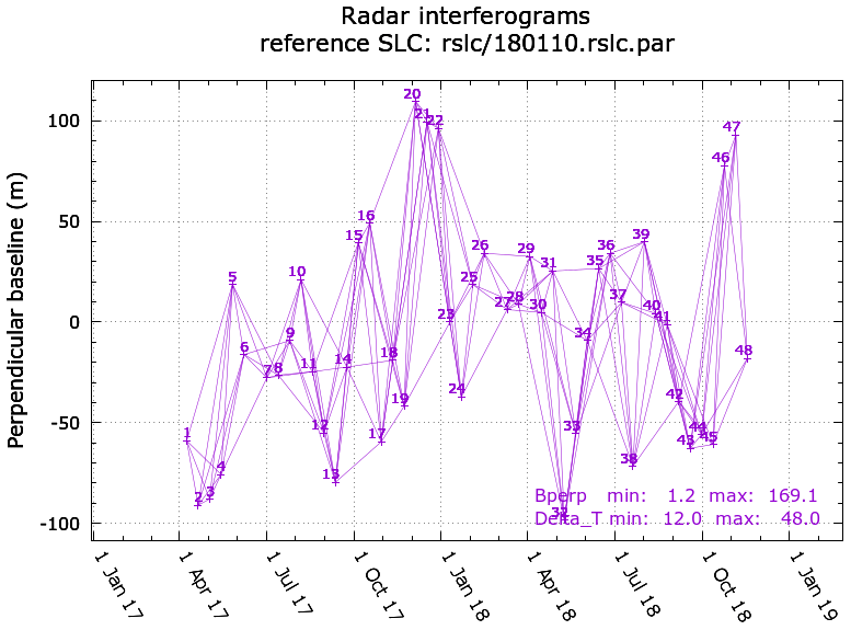
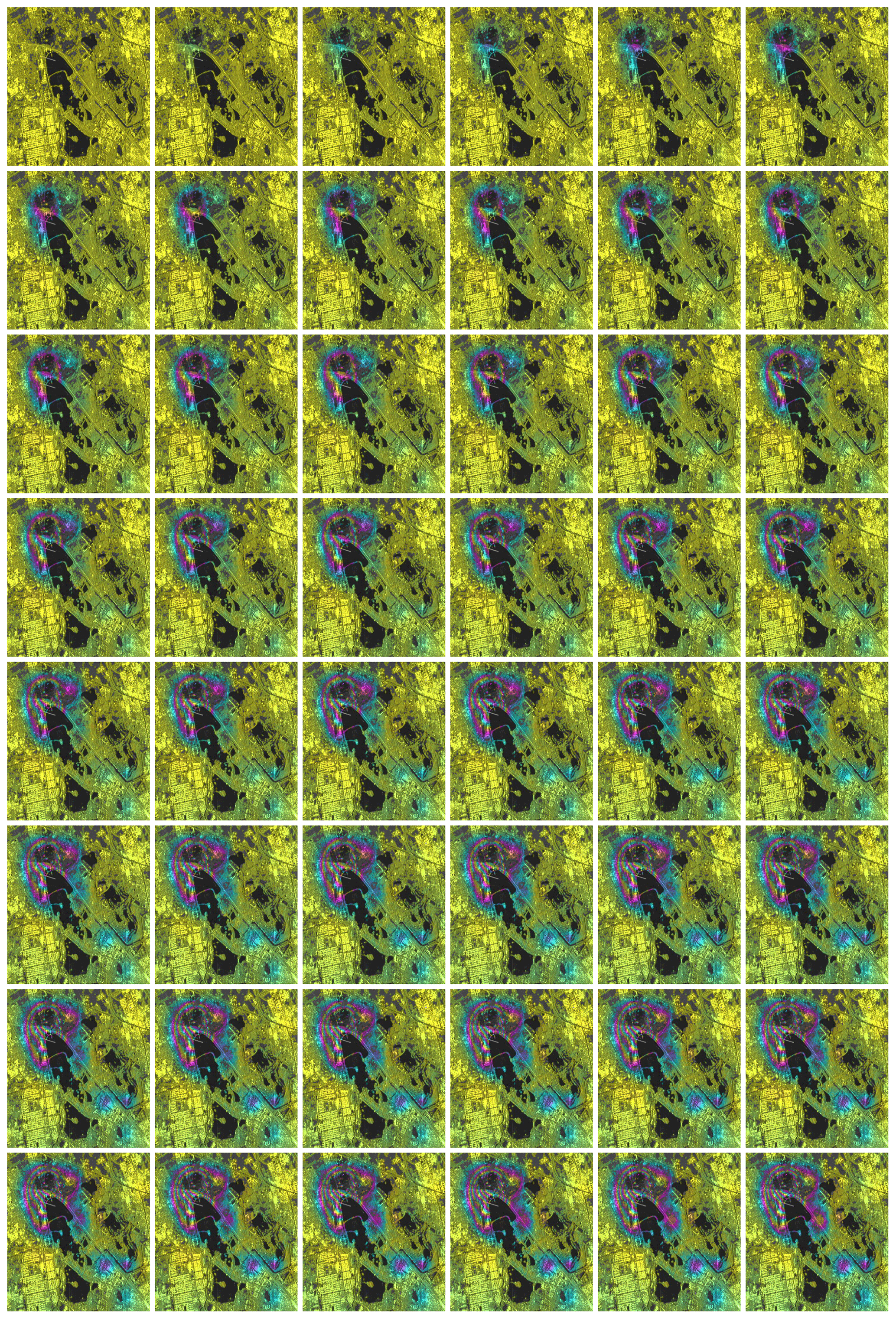
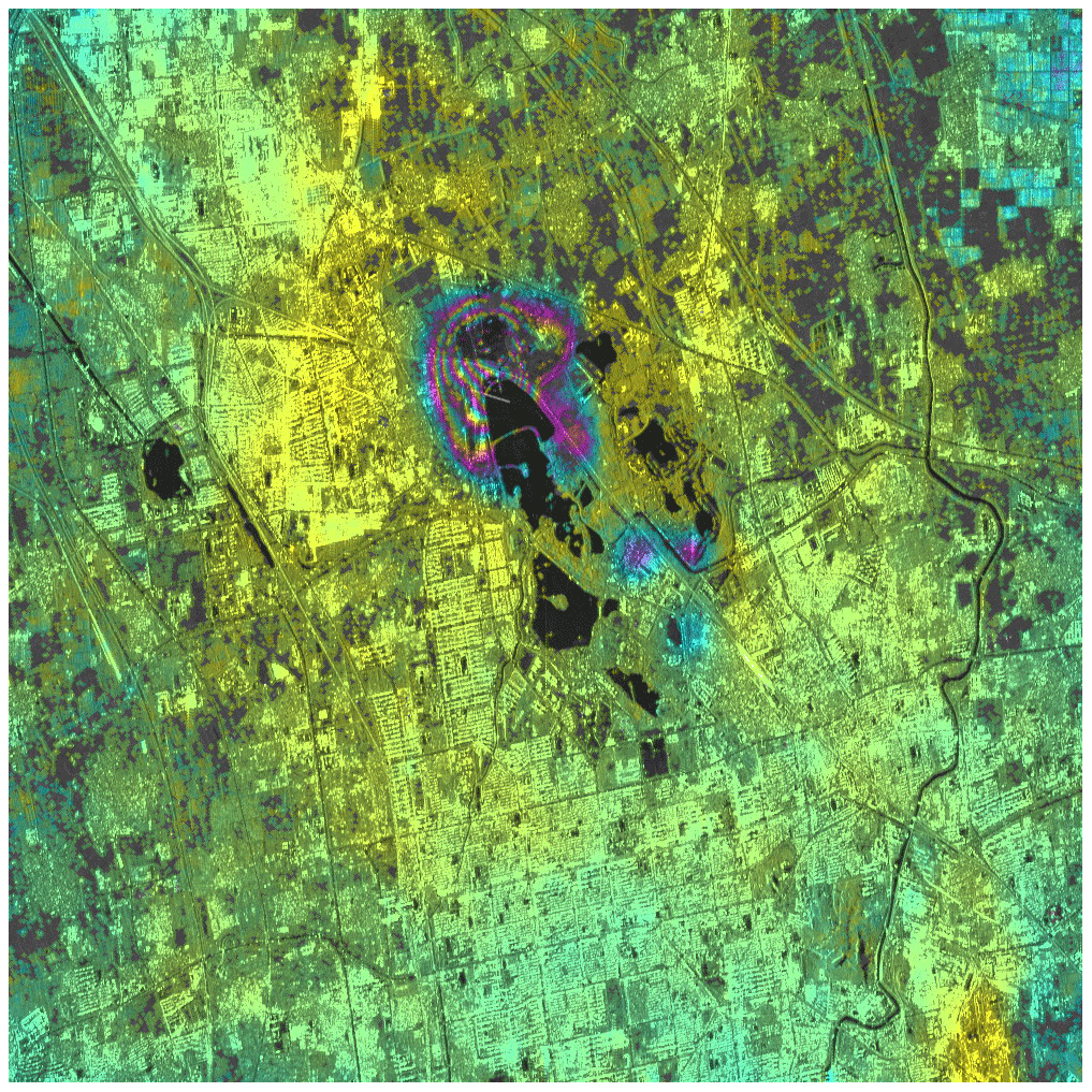
Land subsidence can be caused by underground mining activities. Interferometric Synthetic Aperture Radar (InSAR) has became an economic, effective and accurate technique for land deformation survey and monitoring. In mining areas, there may be several factors to overcome for the succsessful application of InSAR, such as temporal decorrelation and detectable deformation gradient, that limit the ability of InSAR to monitoring rapid land subsidence. In this paper, images obtained by the Sentinel-1 satellite with 6 or 12 d revisiting time are used to improve the ability to detect a deformation gradient, and reduce the influence of temporal decorrelation. By combining Small Baseline Subsets (SBAS) and Interferometric Point Target Analysis (IPTA) methods, using the Nanhu mining area in Tangshan as an example, the spatial continuous results of land subsidence in this mining area are obtained with a 70 cm per year maximum rate, which clearly characterizes the deformation field and its deformation process. The results show that InSAR is a useful way to monitor land subsidence in a mining area and provides further data for environment mine restoration.

1 Introduction

Ground subsidence, is a major hazard that threatens the viability and sustainable economic development; it is an important process that often accompanies underground mining activities. Tangshan, a coastal city located in the center of the Bohai Bay in Hebei province in China, is a mining city with 49 different mineral extraction. The main minerals extracted are coal, iron, gold and limestone (including cement, alkali, flux, limestone for ash), dolomite for metallurgy, oil and natural gas. The coal reserves are 5,12 billion tons and thus underground coal mining is the main driving process of land subsidence in the Tangshan urbanized area.

The surface deformation caused by underground mining activities in coal mining areas usually present a non-linear characteristic due to the nature of mining activities, which may brings out relatively rapid surface deformation. InSAR, as an effective technique for land surface deformation monitoring, has been used in the investigation and monitoring of many kinds of surface deformation. The necessary condition for interferometry implies that maximum detectable deformation gradient is one fringe per pixel, or the dimensionless ration of pixel size to the wavelength (Graham, 1974). The maximum deformation gradient (dx) can be defined as a dimensionless ration of half the wavelength (λ) to pixel size (η) as following Eq. (1):

(1) d x = λ 2 η .

In the previous survey (Zhang et al., 2012) and monitoring of mining deformation, due to the rapid rate of deformation in mining areas and the rapid change of surface vegetation, the time segment of surface deformation through radar interferometric image pairs with good temporal coherence in winter can be obtained. The maximum detectable gradient of InSAR technology is related to the wavelength of radar antenna, the spatial resolution of SAR image and the satellite revisiting period. The longer wavelength and the higher spatial-temporal resolution acquisitions used, the maximum detectable deformation gradient between pixels can be achieved.

To monitor land deformation in mining area effectively, Sentinel-1 images are used. The Sentinel-1A and B satellites with 6 or 12 d revisiting time has a great ability to detect deformation gradients, and reduce the influence of temporal decorrelation. According to Eq. (1), for the satellites sentinel-1A and sentinel-1B, the maximum detectable deformation gradient is equal to 1.4 cm, with the interferogram pixel size 20 m × 20 m. Compared to ERS or ENVISAT 35 d and RADARSAT 24 d revisiting time, Sentinel-1 6 or 12 d revisiting time enhances detection capacity by four times.

By combining Small Baseline Subsets (SBAS) (Berardino et al., 2002) and Interferometric Point Target Analysis (IPTA) (Werner et al., 2003) methods, the spatial continuous results of land subsidence in the mining area show a maximum rate of 70 cm per year in the Nanhu mining area.

2 InSAR deformation monitoring technology

SAR satellites acquisition of the Earth's surface, consists of phase and intensity. After conjugate multiplication of two radar data, the interferometric phase difference between the two SAR images is the target motion occurring along the sensor-target line-of-sight direction during that time interval. The interferometric phase can be expressed by Eq. (2):

(2) φ int = φ top + φ flat + φ def + δ φ atm + δ φ n .

The φtop is terrain phase, the φflat represents flat phase, the φdef is the phase caused by the Earth's surface deformation (along the line of sight, LOS), the δφatm is atmospheric phase difference between the images, and the δφn is the phase according to noise. After the separation of the phase calculation by an external digital elevation data, atmospheric data and imaging geometry, the deformation of LOS ΔR can be calculated form Eq. (3):

(3) φ def = 4 π λ × Δ R .

The resulting differential interferogram may affected by many factors, including atmospheric disturbance, the spatial and the temporal decorrelation. There are two main techniques to overcome these limitations, SBAS and coherence targets analysis (Werner et al., 2003; Ferretti et al., 2001).

The SBAS approach offers a practical way by making use of a limited number of SAR data, in which the data interferometric pairs are appropriately combined with small orbital separation to reduce the spatial decorrelation phenomena. The IPTA process developed by GAMMA Remote Sensing is a coherence targets analysis method. In this case, we combine the SBAS and IPTA methods to obtain the deformation time series of the Nanhu mining area.

3 Results

In this paper, Sentinel-1 mission IW (Interferometric Wide Swath Mode) data are used to monitor the surface deformation in the Nanhu mining area, and using the SRTM DEM as and external elevation data for the surface deformation analysis. The land subsidence from April 2017 to November 2018 is calculated using 48 images with the IPTA (Interferometric Point Target Analysis) technique. There are 170 interferograms generated from 48 images with temporal baseline less than 48 d and spatial baseline less than 200 m, as shown in the baseline graph (Fig. 1).

The selection threshold of coherent points is lowered to obtain denser cloud of point targets, which is suitable for a small deformation area (5000×1000 pixels in this case; 1000×1000 pixels after 5×1 multilook). This results in 1 399 909 coherent points candidate for the IPTA analysis.

https://www.proc-iahs.net/382/237/2020/piahs-382-237-2020-f01

Figure 1Baseline graph used to calculate interferometric pairs.

Download

The subsidence rate and time series of point targets are obtained using the GAMMA IPTA processing tool to describe the deformation state and development trend related to the mining activities in the study area. The results present many details even in the fast deformation area with the maximum subsidence more than 1 m, where the subsidence cannot be detected by temporal decorrelation before, only the deformation scope can be detected (Zhang et al., 2012) . Compared with ENVISAT and RADARSAT SAR data, the Senteinel-1 IW data with 12 d time resolution improves the detection ability of deformation gradient in the mining area. It can not only detect the deformation field, but also describe the deformation magnitude and process in greater detail. Figure 2 shows the deformation time series at 48 image acquisition time in the Nanhu mining area. The Nanhu wetland park that used to be the subsidence area of the coal mine, where the World Horticultural Expo 2016 was held, is a typical example of a mine subsidence restoration. Although the surface of the Nanhu Lake has been restored as a recreational area, the underground mining activities below the Nanhu Lake have never stopped. The surface deformation accumulation is growing larger due to the contonous underground coal mining. From April 2017 to November 2018, the maximum displacement measured was up to 1.20 m. From the analysis of Fig. 2, seventh image, another 3 subsidence centers in the lower right corner of the images are recognized.

https://www.proc-iahs.net/382/237/2020/piahs-382-237-2020-f02

Figure 2Deformation time series of the Nanhu mining area. (The bottom gray images are sentinel-1 radar image and superimposed color fringes present the deformation velocity, one color cycle represents 20 cm.)

Figure 3 is the time series of the fastest subsidence point target (point ID 349 097, pixel coordinate x: 2249, y: 331), with a 70 cm per year subsidence rate.

https://www.proc-iahs.net/382/237/2020/piahs-382-237-2020-f03

Figure 3Displacement time series at the subsidence center of the Nanhu mining area.

Download

Figure 4 shows the deformation rate of the Nanhu mining area, from April 2017 to November 2018. The maximum rate is 70 cm per year, the subsidence field is is clearly recognized, and the deformation is spatially continuous.

https://www.proc-iahs.net/382/237/2020/piahs-382-237-2020-f04

Figure 4Deformation velocity of the Nanhu mining area. (The bottom gray image is sentinel-1 radar image and superimposed color fringe presents deformation velocity, one color cycle represents 10 cm per year.)

4 Conclusions

The application of Sentinel-1 SAR data for land subsidence induced by underground mining operation is described, using a combined InSAR SBAS and IPTA approach. The results show the rapid surface deformation (up to 70 cm per year) caused by the underground mining activity. The cumulative subsidence time series for each coherent point can be retrieved at each image acquisition time (e.g. Fig. 3).

Sentinel-1 data is more suitable for detection of rapid deformation in mining areas than other mid-spatial resolution SAR satellites data due to its shorter revisiting period. With the development of satellite radar technology, InSAR has become an effective and efficient tool for monitoring surface movements, including both rapid and slow rates resulting from earthquakes, volcanic activity to landslide, mine, land subsidence, and engineering deformation.Combining with the prior model of mining deformation, forming a “space-ground” three-dimensional monitoring network with ground leveling, GPS or layerwise mark, InSAR is becoming a useful technique to monitor land subsidence in mining areas and provides basic data for mining environment restoration.

Data availability

The Sentinel-1 data can be download from https://scihub.copernicus.eu/dhus, last access: 12 March 2020. After registration, the data downlinks will apparent with the search criteria (Mission: Sentinel-1, Product Type: SLC, Sensor Mode: IW,and Relative Orbit Number: 69). The external elevation data SRTM DEM can be downloaded directly from the following weblink: https://dds.cr.usgs.gov/srtm/version1/Eurasia/, last access: 12 March 2020.

Author contributions

LZ, DG and XG designed the experiments. LZ and ML performed the experiments. LZ, XG and YW analyzed the results. LZ, XG and BL wrote the manuscript.

Competing interests

The authors declare that they have no conflict of interest.

Special issue statement

This article is part of the special issue “TISOLS: the Tenth International Symposium On Land Subsidence – living with subsidence”. It is a result of the Tenth International Symposium on Land Subsidence, Delft, the Netherlands, 17–21 May 2021.

Acknowledgements

The authors thank GAMMA Remote Sensing for their continuous technical services, and ESA for the open access to Sentinel-1 data.

Financial support

This research has been supported by the National Key Research and Development Program of China (grant no. 2017YFB0502700), the National Key Research and Development Program of China (grant no. 2017YFB0503803), and the China Geological Survey Project (grant no. DD20190513).

References

Berardino, P., Fornaro, G., Lanari, R., and Sansosti, E.: A new algorithm for surface deformation monitoring based on small baseline differential SAR interferograms, IEEE T. Geosci. Remote, 40, 2375–2383, 2002. 

Ferretti, A., Prati, C., and Rocca, F.: Permanent Scatterers in SAR Interferometry, IEEE T. Geosci. Remote, 39, 8–20, 2001. 

Graham, L. C.: Synthetic interferometer radar for topographic mapping, Proc. IEEE, 62, 763–768, 1974. 

Werner, C., Wegmuller, U., Strozzi, T., and Wiesmann, A.: Interferometric Point Target Analysis for Deformation Mapping, IEEE T. Geosci. Remote, 7, 4362–4364, 2003. 

Zhang, X. D., Ge, D. Q., Wu, L. X., Zhang, L., Wang, Y., and Guo, X. F.: Study on Monitoring Land Subsidence in Mining City Based on Coherent Target Small-baseline InSAR, J. China Coal Soc., 37, 1606–1611, 2012. 

Download
Short summary
Land subsidence, is a major problem that threatens the sustainable economic development. InSAR has became an economic, effective and accurate technique for land deformation monitoring. For rapid deformations, temporal decorrelation and detectable deformation gradient limit monitoring capacity of InSAR. In this work, images obtained by the Sentinel-1 satellite are used to improve the ability.The rapid cumulative subsidence time series can be retrieved at each image acquisition.