the Creative Commons Attribution 4.0 License.
the Creative Commons Attribution 4.0 License.
 | 22 Apr 2020
Land subsidence contribution to coastal flooding hazard in southeast Florida
Talib Oliver-Cabrera
Simone Fiaschi
Over the past decade, several coastal communities in southeast Florida have experienced a significant increase in flooding frequency, which has caused significant disturbance to property, commerce, and overall quality of life. The increased flooding frequency reflects the contribution of global, regional, and local processes that affect elevation difference between coastal communities and rising sea level. In a recent project, funded by the state of Florida, we monitor coastal subsidence in southeast Florida using GPS and InSAR observations, in order to evaluate the contribution of local subsidence to the increased coastal flooding hazard. Preliminary results reveal that subsidence occurs in localized patches (< 0.02 km2) with magnitude of up to 3 mm yr−1, in urban areas built on reclaimed marshland. These results suggest that contribution of local land subsidence affect only small areas along the southeast Florida coast, but in those areas coastal flooding hazard is significantly higher compared to non-subsiding areas.
- Article
(5439 KB) - Full-text XML
- BibTeX
- EndNote


Several coastal communities in southeast Florida have been periodically subjected to flooding events, which have been induced by heavy rain, high tide, and storm surge. The frequency of the flooding events has increased over the past two decades causing property damage, transportation problems, an overall impact on daily life. Our recent study of flooding hazard in Miami Beach has shown that flooding frequency in the city doubled during the years 2006–2013 compared to the previous eight-year period of 1998–2005, mainly due to an increased number of high tide events (Fig. 1) (Wdowinski et al., 2016).
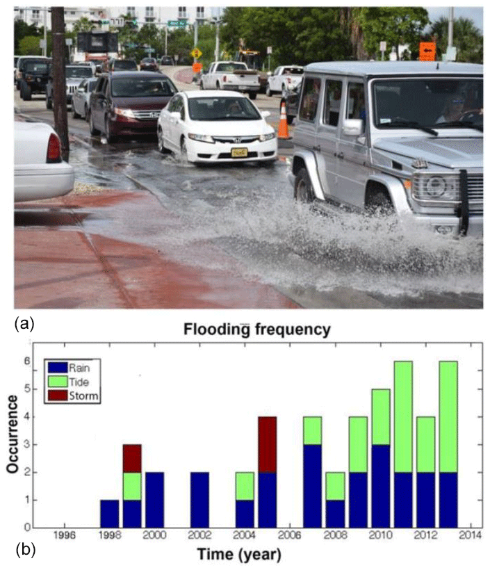
Figure 1(a) “Sunny sky” flooding in Miami Beach. (b) Annual flooding occurrence in Miami Beach between 1998–2013 indicating a significant increase in tide flooding events (green) since 2006 (modified after Wdowinski et al., 2016).
The increased flooding frequency reflects the contribution of global, regional, and local processes that affect elevation difference between coastal communities and rising sea level. Along the US Atlantic coast, the increasing coastal flooding has occurred mainly due to higher sea level, but has also been affected by land subsidence. In order to evaluate the contribution of land subsidence to coastal flooding hazard in southeast Florida, we began a new subsidence monitoring project, which is supported by the Florida Office of Insurance Regulation. The monitoring relies on two geodetic techniques, GPS and Interferometric Synthetic Aperture Radar (InSAR), as well as on visual field observations. The two geodetic techniques provide observations of surface changes over time with different spatial and temporal resolutions and, hence, complement one another. The project supports the construction of four continuous GPS (cGPS) stations, which are currently being constructed in four locations in southeast Florida. In addition, the project supports InSAR data processing of both archive and current data.
This study describes the geodetic monitoring project, which aims at quantifying the spatial extent and rates of coastal subsidence in southeast Florida. We first present field observations indicative of land subsidence in various locations along the southeast Florida coastline. Based on the observed subsiding areas, we selected locations for constructing four continuous GPS stations, which are described in the geodetic monitoring section on the study. We also describe the planned InSAR monitoring analysis as well as presenting preliminary InSAR results of archived ERS-1/2 data. Based on the preliminary InSAR results, we discuss the contribution of local land subsidence to coastal flooding hazard in southeast Florida.
Subsidence in Florida typically occurs at the local scale due to soil oxidation, sediments compaction, and sinkhole activity. Regional scale subsidence due to Glacial Isostatic Adjustment occurs in many sections of continental US, but is negligible in Florida (Sella et al., 2007; Kargar et al., 2016). Also, the tectonic stability of the Florida peninsula suggests negligible tectonic-induced subsidence in Florida.
In southeast Florida subsidence occurs mainly due to sediment compaction, as urban development took place, in part, on reclaimed marshland. Marshland subsidence is a natural process that is often compensated by sediment accretion during inundation events (Nicholls, 2004). However, in reclaimed marshlands, inundation prevention and lack of and sediment supply result in land subsidence. Differential subsiding urban areas often result in structural damage to building and structures, which can be used as proxies for land subsidence.
Along the southeast Florida coast, we observed structural damage to buildings in several coastal parks, including Matheson Hammock, Morningside, and Haulover, as well in the Kovens Conference Center at the Biscayne Bay Campus of Florida International University (Fig. 2). All four locations were constructed between 1930–1960 on reclaimed marshland. The observed structural damage in these locations suggest that local land subsidence is an active process reducing the elevation of some section of the southeast Florida coast.
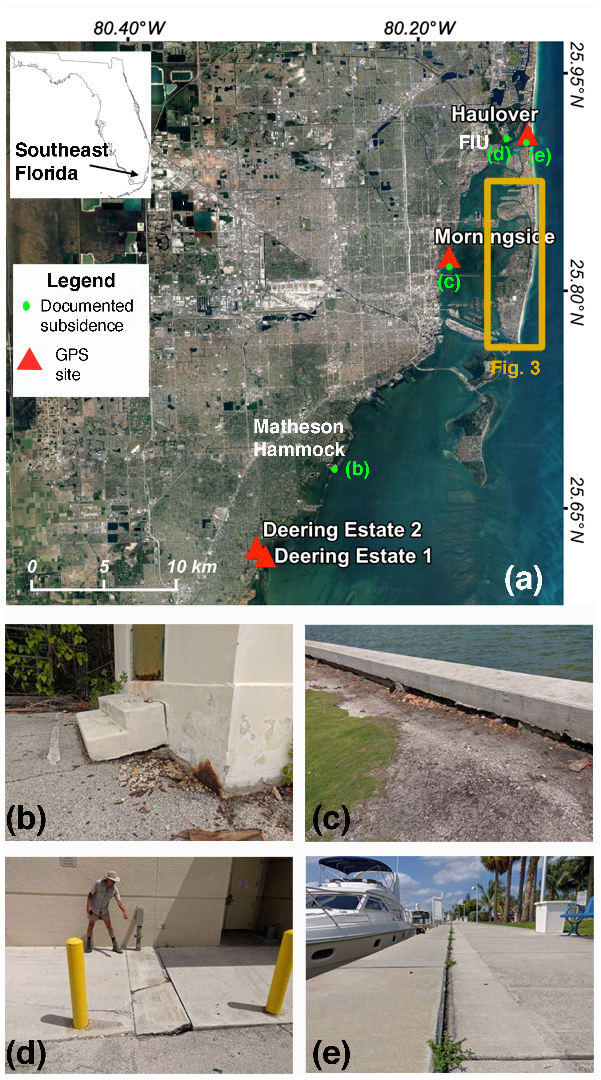
Figure 2(a) Location map of our study area in southeast Florida based on a ©Google Map imagery. The map shows the location of documented coastal subsiding areas and planned GPS sites. Insert shows the location of the study area with respect to state of Florida. (b) Subsidence-induced structural damage to a building in Matheson Hammock Park. (c) Observed subsidence along seawall in Morningside Park. (d) Subsidence-induced structural damage at the entrance to the Kovens Conference Center at the Biscayne Bay Campus of Florida International University (FIU). (e) Observed subsidence along seawall in Haulover Park.
In order to quantify the distribution and rate of coastal subsidence along the southeast Florida shoreline, we began a geodetic monitoring project, which is supported by the Florida Office of Insurance Regulation. The monitoring relies on two geodetic techniques, GPS and InSAR, which compliments one another. Continuous GPS measurements provide high temporal 3-D positioning observations at limited number of observation points with respect to an external reference frame. Whereas, InSAR provides high spatial resolutions observations of surface changes in line of sight (LOS) between the satellite and the surface, with respect to an arbitrary internal reference point. InSAR-based subsidence measurements are of higher quality in urban settings and arid environments than in vegetated areas, due to the scattering behaviour of each land cover. By using both measuring techniques, we will obtain detailed information of subsidence process in four selected locations and less detailed, but with very good spatial coverage of land subsidence along most of the urban sections of southeast Florida coastline.
3.1 Continuous GPS
Precise GPS measurements require the installation of cGPS stations in coastal subsiding areas and monitoring the subsidence over a period of at least 3–4 years. This project supports the installation of four cGPS stations along the southeast Florida shoreline. Because during the writing of this proceedings the four cGPS stations are still in the planning stage, we describe here the site selection criteria and related activities, as well as the planned monitoring activities.
The first year of the project was devoted to site selection and obtaining permits to install the four cGPS stations. Apparently, this task was found to be much more difficult than anticipated, because most of the urban sections of southeast Florida coastline is privately owned. All of our attempts to install cGPS stations in backyards of private homes along the shorelines failed. Thus, we needed to select cGPS site locations on public land, which is a long process requiring permits by the local authorities. During the first year of the project, we identified fifteen possible sites on public land, as well as on private schools. Some locations were found to be unsuitable in terms of physical conditions (small plots, too many trees, or building plans for the area), whereas in some locations we were not able to obtain the required permit. By the end of the process, we identified four sites for cGPS station installation.
The selected locations include two sites in the Deering Estate, one in Morningside Park, and one in Haulover Park (Fig. 2a). The two sites in the Deering Estate are located on two different geological settings in two sides of the county park. The eastern site, located near the shoreline on peat soil, will be used to measure coastal subsidence. The western site, located on a limestone ridge, will be used as a control point to measure the stability of houses and infrastructure built on limestone. The two sites in Morningside and Haulover parks are located on unconsolidated sediments and will be used for monitoring coastal subsidence (Fig. 2c and e).
As soon as permits will be issued for the four sites, the cGPS stations will be conducted and start operating. The station construction and data downloading, archiving and processing will be conducted by UNAVCO (https://www.unavco.org/data/gps-gnss/gps-gnss.html, last access: 26 February 2020), which operate more than 1500 cGPS stations, including the Plate Boundary Observatory (PBO) and the Continuously Operating Caribbean GPS Observational Network (COCONet).
3.2 InSAR analysis
This geodetic monitoring project also support InSAR data processing of both current and archived data. The analysis of current, Sentinel-1 data, did not reveal yet significant results, because the observation time span (2015–2019) is too short for obtaining velocity measurement with 1–2 mm yr−1 uncertainty level (Havazli and Wdowinski, 2017). Actually, the effective Sentinel-1 observation period for southeast Florida is even shorter (only 3 years), because systematic data acquisition every 12 d repeat path began in September 2016. In order to obtain subsidence measurements at the 1–2 mm yr−1 uncertainty level, Sentinel-1 time series should extend for a period of at least five years (Havazli and Wdowinski, 2017). We will continue processing Sentinel-1 data after obtaining sufficiently long data span (> 5 years).
InSAR data analysis of archived ERS-1/2 data yielded significant results with the desired accuracy of 1–2 mm yr−1 (Fiaschi and Wdowinski, 2019). The ERS-1/2 data were acquired during 1993–1999 and cover a total period of 7 years. We processed the data using the Small Baseline Subset (SBAS) algorithm (Berardino et al., 2002) with 24 acquisitions and 95 interferometric pairs. Data analysis includes multi-looking (1×5), topography phase removal (1 arcsec SRTM), ESA's Precise Orbits, Goldstein adaptive filter (Goldstein and Werner, 1998), co-registration using the Delaunay Minimum Cost Flow (MCF) algorithm (Costantini, 1998), and Atmospheric Phase Screen removal by applying spatial (low-pass) and temporal (high-pass) filters. More details of data analysis are provided in Fiaschi and Wdowinski (2019).
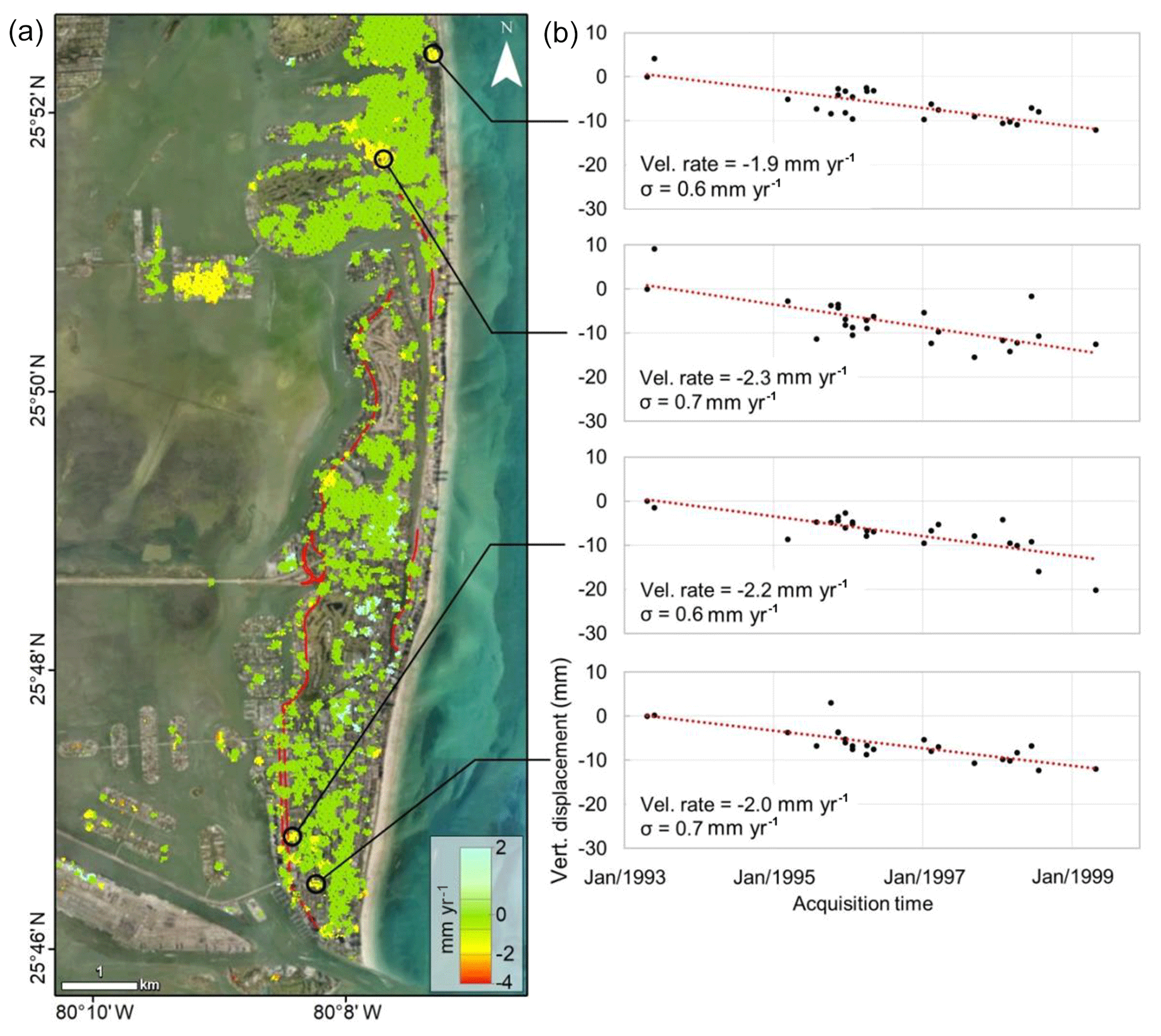
Figure 3Vertical velocity map over Miami Beach from 1993–1999 and displacement time series (from Fiaschi and Wdowinski, 2019). (a) vertical velocity map obtained with the SBAS technique. The black circles mark the location of the extracted displacement time series. Red lines mark the location of roads affected by flooding during 1998–2012 (data from Wdowinski et al., 2016). Base image source: Esri, DigitalGlobe, GeoEye, Earth Geographics, CNES/Airbus DS, USDA, USGS, AeroGRID, IGN, and the GIS User Community. (b) Vertical displacement time series of the four selected points.
Our ERS-1/2 InSAR analysis focused on subsidence within the city of Miami Beach, which have been subjected to periodic flooding (Fig. 1). Miami Beach is a densely populated barrier island, roughly 10 km long and 2.5 km wide at its widest point (Fig. 3). Our InSAR time series results reveal a patch-like pattern of coherent velocity observations located mainly over the built environment. The results indicate that most of the city (∼97 %) was stable during the 1993–1999 observation period (green in Fig. 3a). Several localized subsiding areas (< 0.02 km2) were detected mostly in the western and eastern parts of the city (yellow in Fig. 3a). The detected subsidence rate is generally in the 1–3 mm yr−1 range, with uncertainty level of 0.6–0.8 mm yr−1. Uncertainties are calculated for each pixel, based on their multi-temporal coherence values.
Increasing flooding frequency in several coastal communities along the southeast Florida coastline resulted in damage to property, commerce, and overall quality of life. The increased flooding frequency reflects increasing rate of relative sea level rise, mostly due to ocean dynamic contributions, but possibly also due to coastal subsidence. In order to evaluate the contribution of land subsidence to the coastal flooding hazard, we began a geodetic monitoring project that uses both cGPS and InSAR observations. The project supports the construction of four cGPS stations that will be constructed on subsiding public land along the southeast Florida coastline. The project also supports InSAR monitoring of the urban environment in southeast Florida. Preliminary results reveal that subsidence occurs in localized patches with magnitude of 1–3 mm yr−1, mainly in urban areas built on reclaimed marshland. These preliminary results suggest that land subsidence affect only small areas along the southeast Florida coast. However, in these areas coastal flooding hazard is significantly higher compared to non-subsiding areas. As part of the project, we will also conduct InSAR time analysis of Sentinel-1 data, which have been acquired systematically since 2016.
GPS data will be archived by UNAVCO (https://www.unavco.org/data/gps-gnss/gps-gnss.html, UNAVCO Data Archive Interface Version 2 (DAI v2), 2020). ERS-1/2 data are provided by ESA through the EOLi-SA (Earth Observation Link) client for Earth Observation Catalogue Service (https://esar-ds.eo.esa.int/oads/access/, ESA Online Dissemination, 2020)
SW initiated the study and wrote the manuscript, SW and TOC carried the field survey including GPS site survey, SF conducted the InSAR analysis, SF and SW interpreted the InSAR results.
The authors declare that they have no conflict of interest.
This article is part of the special issue “TISOLS: the Tenth International Symposium On Land Subsidence – living with subsidence”. It is a result of the Tenth International Symposium on Land Subsidence, Delft, the Netherlands, 17–21 May 2021.
The authors thank UNAVCO and particularly John Galetzka for helping selecting and constructing the CGPS stations. This is contribution number 952 from the Southeast Environmental Research Center in the Institute of Environment at Florida International University.
This research has been supported by the Florida Office of Insurance Regulation.
Berardino, P., Fornaro, G., Lanari, R., and Sansosti, E.: A new algorithm for surface deformation monitoring based on small baseline differential SAR interferograms, IEEE T. Geosci. Remote, 40, 2375–2383, 2002.
Costantini, M.: A novel phase unwrapping method based on network programming, IEEE T. Geosci. Remote, 36, 813–821, 1998.
ESA Online Dissemination: The archive provides a high-performance infrastructure for storing and providing access to ESA EO data, available at: https://esar-ds.eo.esa.int/oads/access/, last access: 26 February 2020
Fiaschi, S. and Wdowinski, S.: Local land subsidence in Miami Beach (FL) and Norfolk (VA) and its contribution to flooding hazard in coastal communities along the US Atlantic coast, Ocean Coast. Manag., 187, 105078, https://doi.org/10.1016/j.ocecoaman.2019.105078, 2019.
Havazli, E. and Wdowinski, S.: The Effect of Temporal Resolution Due to Atmospheric Phase Delay on Minimum Detectable Signal in InSAR Time Series: Application to Slow Deformation over Socorro Magma Body, in: FRINGE, Helsinki, Finland, 2017.
Karegar, M. A., Dixon, T. H., and Engelhart, S. E.: Subsidence along the Atlantic Coast of North America: Insights from GPS and late Holocene relative sea level data, Geophys. Res. Lett., 43, 3126–3133, 2016.
Nicholls, R. J.: Coastal flooding and wetland loss in the 21st century: changes under the SRES climate and socio-economic scenarios, Glob. Environ. Change, 14, 69–86, 2004.
Sella, G. F., Stein, S., Dixon, T. H., Craymer, M., James, T. S., Mazzotti, S., and Dokka, R. K.: Observation of glacial isostatic adjustment in “stable” North America with GPS, Geophys. Res. Lett., 34, 1–6, 2007.
UNAVCO Data Archive Interface Version 2 (DAI v2): Data of interest to you using a variety of filters (Metadata, Spatial, and Temporal), available at: https://www.unavco.org/data/gps-gnss/gps-gnss.html, last access: 26 February 2020
Wdowinski, S., Bray, R., Kirtman, B. P., and Wu, Z. H.: Increasing flooding hazard in coastal communities due to rising sea level: Case study of Miami Beach, Florida, Ocean Coast. Manag., 126, 1–8, 2016.