the Creative Commons Attribution 4.0 License.
the Creative Commons Attribution 4.0 License.
Augmented-reality-based snow visibility simulation for disaster preparedness in the Western Himalayas
RAAJ Ramsankaran
Snow-induced disasters pose significant risks in mountainous regions. Accurate visibility assessment is crucial for informed decision-making and disaster preparedness. This paper presents an innovative approach that integrates theoretical literature with practical application using augmented reality (AR) to address this challenge. The proposed system, named Him-Drishti, harnesses the established correlation between snowfall intensity and visibility to create a predictive model. By incorporating user-input snowfall intensity predictions, the Him-Drishti AR application dynamically overlays real-time visibility simulations onto the physical environment. Moreover, the use of smartphones further amplifies the practicality of this innovative solution, making the AR application a handy tool, even in the most challenging terrain. This intuitive visualization empowers stakeholders with a comprehensive understanding of potential risks, facilitating informed decisions and optimized disaster response strategies. Through AR visualization, stakeholders, emergency responders, and local authorities gain valuable insights into visibility conditions, enabling them to make informed decisions, take proactive measures, and allocate resources effectively. This study not only enhances the understanding of snow-related disasters but also demonstrates the capacity of AR in disaster management and risk reduction.
- Article
(3566 KB) - Full-text XML
- BibTeX
- EndNote
In recent times, there has been an apparent rise in extreme weather and climatic events on a global scale. This trend is anticipated to intensify in terms of both frequency and severity, as emphasized in a report by the Intergovernmental Panel on Climatic Change (IPCC, Climate Change 2023). Although the future prospects for snowfall in midlatitudes appear bleak due to global warming, extreme snowfall occurrences remain a prominent and destructive category of extreme weather phenomenon, especially in the Northern Hemisphere (Quante et al., 2021).
Extreme snowfall events emerge as potent disruptors that are capable of impacting diverse aspects of urban life, particularly in the realms of air and ground transportation (Santiago-Iglesias et al., 2023). Furthermore, snowfall disasters have claimed numerous lives. In a recent occurrence, 27 lives were lost in India in 2022 due to snowfall disasters (Annual Report, 2023). These events emphasize the critical need for advanced tools and technologies to mitigate the impacts of snow-induced disasters.
Adaptive capacity stands as a key component in the realm of disaster risk reduction, as highlighted within the overarching conceptual frameworks of vulnerability and risk (IPCC, Climate Change 2023). This imperative extends beyond immediate hazard response and encompasses climate change impact mitigation (Sharma and Patwardhan, 2008).
A crucial element of adapting to hazards is risk communication. Existing research on risk communication has predominantly focused on the viewpoint of information senders, often neglecting the choices made by receivers (Palttala et al., 2011). There is a noticeable gap in scientific attention when it comes to recipient perspectives on information usage and risk perception during snow events (Adekola et al., 2021).
Conventional methods with respect to visualization techniques, including PowerPoint presentations (Koutitas et al., 2019), didactic training (Rossler et al., 2019), and walk-throughs of systems (Koutitas et al., 2019), have long been utilized. However, recent advancements in extended-reality (XR) technologies have showcased their superiority over these conventional methods. Augmented reality (AR) and virtual reality (VR) have demonstrated enhanced effectiveness in various immersive applications and outperformed their traditional counterparts (Koutitas et al., 2019).
With snow-induced disasters posing significant threats to mountainous areas, there is a critical necessity for innovative solutions in disaster preparedness and mitigation that is exacerbated by climate change. This research addresses the gap in understanding risk perception during extreme snowfall events. Focusing on the hazard of low visibility due to snowfall, the research aims to enhance disaster-response adaptability.
This study introduces an AR-based application named Him-Drishti. The motivation for this study stems from the essential insights provided by Bendickson (2003), who highlighted the correlation between heightened snowfall intensity and reduced visibility. Him-Drishti overlays virtual snow particles onto the real-world environment, offering a controlled, interactive setting for assessing and experiencing snowfall conditions. Him-Drishti provides a unique simulation experience, allowing users to visualize and understand the challenges posed by reduced visibility during snowfall. This innovative approach not only facilitates better preparedness for disaster response but also opens new avenues for training and awareness in the realm of snow-related emergencies.
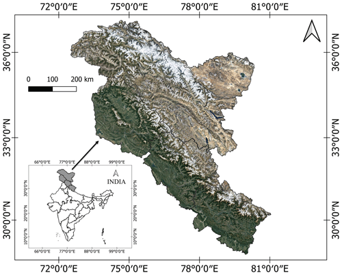
The Western Himalayas span from Jammu and Kashmir to the western border of Nepal, encompassing a substantial area of around 331 392 km2. This region constitutes roughly 10 % of India's overall geographical area. Precipitation in the Western Himalayas, occurring as rain and snow, is influenced by western disturbances from October to May and the southwest monsoon from July to September (Kripalani et al., 2003). Climatic conditions in the area vary with altitude. In the higher regions, temperatures range from 15 to 18 °C in summer, while winters are below the freezing point, leading to permanent snow cover above 4800 m (Rani, 2017).
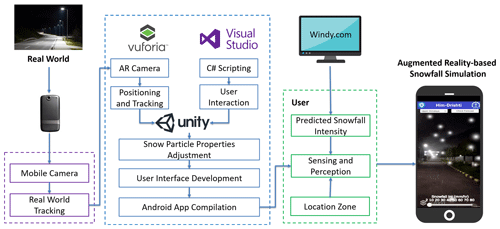
The methodology encompasses several key steps to develop an AR-based snow visibility simulation, as shown in Fig. 2. It begins with the development of virtual snow particles, considering their physical properties and color characteristics. The integration of AR components into real-world environments is achieved by using the features of the Vuforia software development kit (SDK). Finally, the Unity framework is employed for compiling the Android application, resulting in a comprehensive and realistic AR-based snow visibility simulation for smartphones. A detailed methodology is presented in the following sections, providing a comprehensive overview of the steps involved in creating the AR-based snow visibility simulation.
3.1 Snow particle development
In the development of snow particles for the AR-based snow visibility simulation, careful consideration is given to replicating the physical properties of snowfall. To emulate the natural behavior of falling snow, the implementation incorporates realistic gravitational forces that influence the movement of each particle. Snow particle sizes for the various Western Himalayan zones were provided in a study by Negi and Kokhanovsky (2011), and this information is employed in this work to simulate and precisely portray a range of particle sizes, resulting in a visually compelling and true-to-life experience.
Furthermore, careful consideration is given to the color characteristics, transparency, and reflective characteristics of the snow particles in order to improve the simulation's visual accuracy. Snow particles are developed to provide an immersive experience for the user. To incorporate snowfall intensity data into the simulation, the Windy website is utilized as a source of predictive snowfall intensity data. These data are essential to dynamically update the simulation for the user, ensuring that it reflects the predictive snowfall conditions accurately.
3.2 Integration of the AR system into the scene
In this phase, real-world scenes are captured through the smartphone camera to provide the foundation for the simulation. To enhance the scene-capturing capabilities and enable efficient viewing of real-world scenes, the Vuforia SDK is implemented. This SDK not only aids in capturing scenes but also serves as a robust platform for integrating virtual snow particles seamlessly into real-world environments. This integration ensures an immersive and interactive experience for users, allowing them to visualize and interact with the augmented snowfall simulation.
3.3 Graphical user interface (GUI) development
For the development process, Visual Studio is chosen as the integrated development environment (IDE). The development environment plays a crucial role in creating an engaging interface that allows users to interact seamlessly with the AR-based snow visibility simulation.
A snowfall intensity slider is developed to control the simulation with respect to replicating the predictive snowfall intensity conditions from the Windy website. The development of a controlled simulation makes Him-Drishti a valuable tool for users seeking to understand and visualize live snowfall scenarios.
3.4 Compilation of the Android application
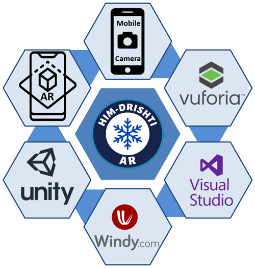
Finally, the Unity cross-platform development framework is employed to provide a robust platform for the Android application development. Unity facilitates the creation of a versatile and accessible application that can be deployed across various Android devices. The combination of Unity, the Vuforia SDK, Visual Studio, and predicted snowfall intensity data from the Windy website contributes to the comprehensive methodology for developing an AR-based snow visibility simulation on a smartphone. The tools and techniques utilized for the study are illustrated in Fig. 3. This approach ensures a realistic and engaging user experience while leveraging AR for an innovative application.
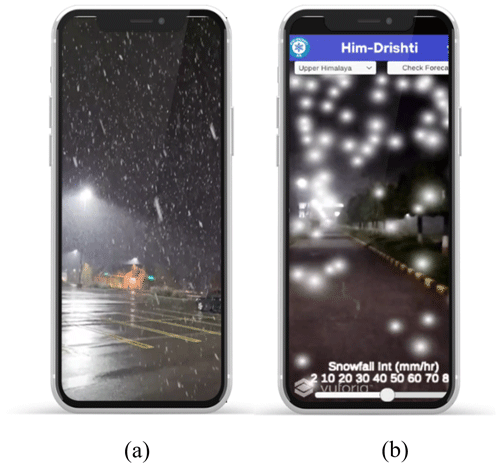
The proposed AR-based snow visibility simulation, Him-Drishti, uses the known link between snowfall intensity and visibility to dynamically add virtual visibility simulations on top real-world scenes, as shown in Fig. 4.
The study's innovative integration of theoretical literature with practical application through AR has yielded a promising system for addressing challenges related to accurate visibility assessments of snowfall events. This approach, implemented on smartphones for enhanced practicality, empowers stakeholders with a comprehensive understanding of potential risks, thereby facilitating informed decision-making and optimized disaster response strategies.
Focusing on the Western Himalayas as a study site, the research underscores the critical need for effective disaster-response adaptability and proactive measures in challenging terrain. Him-Drishti, tailored for this region, emerges as a valuable tool for various applications, including weather analysis, emergency response planning, road maintenance, and winter sports management. The correlation between snowfall intensity and visibility provides crucial insights into the relationship between higher snowfall intensity and reduced visibility. The meticulous development of snow particles for the simulation aims to create a visually compelling and immersive experience.
In essence, the results underscore the transformative potential of AR in disaster management and risk reduction, particularly in the context of snow-induced disasters in mountainous regions. This study contributes not only to the advancement of AR applications in disaster management but also to the broader discourse on adapting technology to suit the unique challenges posed by varied geographical and climatic conditions.
This study introduces a pioneering AR-based snow visibility simulation system, Him-Drishti, tailored for the Western Himalayas, emphasizing its transformative potential in disaster preparedness and risk reduction. The successful integration of snowfall intensity data into the simulations enables a dynamic and accurate representation of snowfall visibility, providing valuable insights for stakeholders in the region. The correlation between snowfall intensity and visibility, elucidated through the study, contributes nuanced understanding for decision-makers, empowering them to formulate effective disaster risk management strategies. The user-friendly interface enhances adaptability and customization, allowing local authorities and emergency responders to tailor responses based on the specific characteristics of the Western Himalayas.
To propel the field forward, future research endeavors should delve into assessing the scalability of the proposed AR snow visibility simulation beyond the Western Himalayas, exploring its applicability in other mountainous regions worldwide. Collaborative efforts with meteorological agencies and disaster management organizations can elevate the practicality and effectiveness of the proposed solution, ensuring its relevance and reliability in varying contexts.
This involves a continual cycle of refining the simulation's accuracy based on user feedback and updated meteorological information. Maintaining a collaborative relationship with stakeholders, including emergency responders and local authorities, is crucial to keeping the application user-friendly and aligned with the evolving needs of these key end users. This iterative approach ensures that the simulation remains a dynamic and responsive tool in the realm of disaster preparedness and risk reduction.
While the proposed AR snow visibility simulation presents a ground-breaking approach, it is essential to acknowledge its current limitations. The simulation does not account for the wind effect, a significant factor during snowstorms that can lead to blizzards. Future iterations could address this limitation by considering wind speed, enhancing the simulation's accuracy, and reflecting a more comprehensive representation of real-world snowfall conditions. Additionally, to further improve the simulation's precision, precise meteorological data can be employed to accurately reproduce snowfall patterns and intensities in the AR environment. Exploring the integration of 360 ° photos for creating simulations in different locations and enhancing the viewing experience with VR and mixed-reality headsets are avenues for future development, ensuring the continuous evolution and advancement of the proposed AR snow visibility simulation system.
The authors are enthusiastic about sharing this innovative AR solution and invite interested readers to contact the authors for access to the tool.
The underlying software code is not publicly accessible because the study area might contain international boundaries and disputed areas. However, the authors are enthusiastic about sharing this innovative AR solution and invite interested readers to contact them for access to the code.
The underlying research data regarding snowfall intensity prediction are available at the Windy website: https://www.windy.com/-Menu/menu?ptype,21.678,86.880,5 (Windy, 2023). Additionally, information on snow particle sizes for various Western Himalayan zones is provided in the study by Negi and Kokhanovsky (2011, https://doi.org/10.5194/tc-5-831-2011). Finally, the Vuforia software development kit can be accessed at the Vuforia Developer Portal: https://developer.vuforia.com/library/getting-started/vuforia-engine-package-unity (Vuforia Developer Portal, 2023).
SS was responsible for the conceptualization, methodology, formal analysis, and writing – original draft. RR participated in the conceptualization, methodology, supervision, and writing – review and editing.
The contact author has declared that neither of the authors has any competing interests.
Publisher's note: Copernicus Publications remains neutral with regard to jurisdictional claims made in the text, published maps, institutional affiliations, or any other geographical representation in this paper. While Copernicus Publications makes every effort to include appropriate place names, the final responsibility lies with the authors.
This article is part of the special issue “Mountain Hydrology and Cryosphere”. It is a result of the International Conference on Mountain Hydrology and Cryosphere, Kathmandu and Dhulikhel, Nepal, 9–10 November 2023.
Adekola, J., Renaud, F. G., and Hill, C.: Risk Information Sources for snow disaster risk preparedness in Scotland, Int. J. Disaster Risk Sci., 12, 854–866, https://doi.org/10.1007/s13753-021-00386-y, 2021.
Annual Report: https://mausam.imd.gov.in/, India Meteorological Department, India Meteorological Department Ministry of Earth Sciences (MoES), Govt. of India, retrieved from https://mausam.imd.gov.in/imd_latest/contents/ar2022.pdf (last access: 14 September 2023), 2023.
Bendickson, S.: Relationship between Visibility and Snowfall Intensity, TP 14151E, https://trid.trb.org/view/755982, retrieved from https://skybrary.aero/sites/default/files/bookshelf/943.pdf (last access: 12 September 2023), 2003.
IPCC, Climate Change 2022: Impacts, adaptation and vulnerability, Intergovernmental Panel on Climate Change (IPCC), https://doi.org/10.1017/9781009325844, 2023.
Koutitas, G., Smith, K., Lawrence, G., Metsis, V., Stamper, C., Trahan, M. H., and Lehr, T.: A virtual and augmented reality platform for the training of first responders of the ambulance bus, ACM Int. Conf. Proceeding Ser, 299–302, https://doi.org/10.1145/3316782.3321542, 2019.
Kripalani, R. H., Kulkarni, A., and Sabade, S. S.: Western Himalayan snow cover and Indian monsoon rainfall: A re-examination with INSAT and NCEP/NCAR data, Theor. Appl. Climatol., 74, 1–18. https://doi.org/10.1007/s00704-002-0699-z, 2003.
Negi, H. S. and Kokhanovsky, A.: Retrieval of snow grain size and albedo of western Himalayan snow cover using satellite data, The Cryosphere, 5, 831–847, https://doi.org/10.5194/tc-5-831-2011, 2011.
Palttala, P., Boano, C., Lund, R., and Vos, M.: Communication Gaps in Disaster Management: Perceptions by Experts from Governmental and Non-Governmental Organizations, J. Contingencies Crisis Manag., 20, 2–12, https://doi.org/10.1111/j.1468-5973.2011.00656.x, 2011.
Quante, L., Willner, S., Middelanis, R., and Levermann, A.: Regions of intensification of extreme snowfall under future warming, Sci. Rep., 11, 16621, https://doi.org/10.1038/s41598-021-95979-4, 2021.
Rani, S.: Evaluating snow cover changing trends of the Western Indian Himalaya, Spat. Inf. Res., 26, 103–112, https://doi.org/10.1007/s41324-017-0158-7, 2017.
Rossler, K. L., Sankaranarayanan, G., and Duvall, A.: Acquisition of fire safety knowledge and skills with virtual reality simulation, Nurse Educ., 44, 88–92, https://doi.org/10.1097/nne.0000000000000551, 2019.
Sharma, U. and Patwardhan, A.: Methodology for identifying vulnerability hotspots to tropical cyclone hazard in India, Mitig. Adapt. Strat. Gl., 13, 763, https://doi.org/10.1007/s11027-008-9145-6, 2008.
Santiago-Iglesias, E., Carpio-Pinedo, J., Sun, W., and Palomares, J. C. G.: Frozen city: Analysing the disruption and resilience of urban activities during a heavy snowfall event using Google Popular Times, Urban Clim., 51, 101644, https://doi.org/10.1016/j.uclim.2023.101644, 2023.
Vuforia Developer Portal: Vuforia software development kit, https://developer.vuforia.com/library/getting-started/vuforia-engine-package-unity, last access: 2 September 2023.
Windy: Snowfall intensity prediction data, https://www.windy.com/-Menu/menu?ptype,21.678,86.880,5, last access: 5 September 2023.


