the Creative Commons Attribution 4.0 License.
the Creative Commons Attribution 4.0 License.
 | 26 Jul 2024
4 “R” Approach of Catastrophic Disaster of Melamchi Flood: A Sustainable Urban Planning
Tapendra Bahadur Khadka
This 4 “R” (i.e., Reclaim, Readjustment of Land, Rehabilitation and Reconstruction) concept is an appropriate solution for a resilient urban environment with sustainable development after the disaster events. On the late night of 16 June 2021, Melanchi Bazar of Nepal a flash flood of outburst of landslide dam created unexpected disaster destroying the lives and properties with the loss of 291 households and displaced more than 600 peoples, cultivated land, and major infrastructures. Land reclaim is necessary in the flood plain area with the “Built Back Better” concept. Land readjustment with new cadastral survey should be conducted to update the existing record of the privatively owned land of the citizens. Rehabilitations of urban facilities, with the function of flood plain area providing the storage to reduce stream velocities during high floods. Revitalization and recuperative treatment of the urban settlements with an enhancement of wetlands, creeks, and river corridors.
- Article
(2999 KB) - Full-text XML
- BibTeX
- EndNote


Melamchi is one of the major emerging urban centres in the area and also the headquarter of the Melamchi Municipality, Sindhupalchok District of Bagmati Province of Nepal. It lies downstream of the confluence of the Melamchi River and the Indrawati River. The origins of these two rivers are from the Himalayan range and sources of water are snowmelt and rainfall. It is located at the latitude and longitude at an elevation of 940 m from the mean seal level.
Melamchi, the urban centre was the destination for the last two decades for domestic as well as international visitors due to the mega national pride infrastructure project Melamchi Water Supply Project. It is also a gateway to Helambu. Melamchi is not only an urban centre, it is developing as a growth centre of surrounding market centres providing the spillover effect to the hinterland promoting the rural-urban linkages. It also helps the adjoining rural municipalities for economic activities providing the market for their cash crop and other agriculture products. Melamchi Municipality also focuses on developing the urban infrastructure to feel their citizens they are urban dwellers.
The late night of 16 June 2021, a flash flood and the outburst of landslide dam created unexpected disaster with the debris flow destroying the lives and properties of Melamchi inhabitants and destroyed number of houses, cultivated land, and major infrastructure along the road alignment. The study reported the loss of 291 households and displaced more than 600 people.
A devastating earthquake with a moment magnitude (Mw) 7.8 hit the central Nepal on 25 April 2015. The epicenter of the earthquake located near Baarpak, Gorkha (28.1470° N, 84.7080° E) 77 km northwest of Kathmandu. Another big aftershock of Mw 7.3 occurred in the northeast of Kathmandu on 12 May 2015 (Collins and Jibson, 2015) with an epicenter in Kodari Sindhupalchowk. It was also followed by more than 424 aftershocks having local magnitude of 4 which caused additional damages.
It is estimated that the lives of eight million people, almost one-third of the population of Nepal, have been impacted by the earthquakes pushing back more than one million people below the poverty line. The adverse effects of earthquake in the geo-spatial location had tremendously affected the surrounding geology of the settlements in the Gorkha and Sindhupalchowk districts were observed and surveyed by the geologist.
Nepal is among the 20th most disaster-prone countries in the world, both natural and man induced. It ranks 4th, 11th and 30th in terms of climate change (CC), earthquake and flood risk respectively (MoHA, 2015). It is the 7th most vulnerable nation in the world for deaths related to floods, landslides and avalanches combined; 8th for flood-related deaths alone; and 23rd in terms of total natural hazard related deaths (MoHA, 2009).
Whereas nearly 25 numbers of multi-hazards are enlisted within the country, Due to the diverse topography, complex geological strata and drastic change in climatic condition due varying altitude of 80 to 8848.85 m the top of World, Nepal is exposed to the many types of man-made and natural disasters. More than 80 % of the population is exposed to the risk of natural hazards (MoHA, 2018). There are many factors that have influenced landslides and flood hazards including high intensity rainfall and changes in land use pattern without considering the objective of the sustainable development.
Landslides are one of the most prevalent multi-hazards frequently occurred in Nepal because of the active seismicity, intensive monsoon rains, and hastened erosion due to haphazard deforestation and expedite in construction. High chances of slope failures and rock falls occurred at shallow depth. Various ground fissures were found in devastated area.
This topic is unique because it is not only directly related with flood disaster mitigation. The major part is reclaimed of destroyed urban land (flood plain). Land readjustment planning also help to relocate the plots of individual land owner. Who lost their land boundary after disaster. It's uniqueness due to Reclaim, Readjustment, Rehabilitation and Reconstruction. When people talk/argue/discuss about flood management they only think about flood modelling, rainfall intensity, high flood levels, climate change, flood affected areas, inundation area, river bank erosion, raise of river beds due to land slide in upstream sides and river training work on the flood plain area. They never think from the side of urban planner and urban planning concept.
It outlines about the disaster risk reduction along the river basin area to develop the plan and policies with critical thinking for resilient community development.
It covers all the sectors of Disaster Risk Reduction including the reclaim, readjustment of land, rehabilitation, and reconstruction areas that have not been previously considered together in flood management sector.
It can be applied to all the disaster-prone area before and after the disaster events to save the life and property of people during disaster and also rehabilitate the existing livelihood too. It also helps to the local community leaders to advocate for specific changes in policies.
After 2015 Gorkha earthquake, National Reconstruction Authority (NRA) carried out a geological investigation sub-dividing of 662 settlements in 3 different categories. There were 136 settlements identified in Category III, 175 settlements in Category II and 351 settlements in Category I respectively. Detail studies of 136 vulnerable settlements have been carried out at various stages.
As per the recommendation of geologists, the government has been initiated to relocate at least 14 vulnerable community settlements of Sindhupalchowk district to the safer places. Few settlements were safer to live in and few settlements were identified to be relocated.
After the disaster Decisions of the Seventh Meeting of National Council for Disaster Risk Reduction and Management held on Tuesday 26 July 2078. With the decision to instruct the National Disaster Risk Reduction and Management Authority (NDRRMA) to conduct a detailed study of the debris flood of the Melamchi River and the risks caused by it and the measures to solve them, including the study of all kinds of past experiences.
After the council decision the NDRRMA quickly responded to the disaster, with a series of activities including a drone survey to identify all damaged houses, map out inundation areas, and record the changes in topography caused by massive erosion and deposition (Takamatsu et al., 2021). Flood modelling has been carried for evaluating future flood risks and policy formulation regarding to fix the setback distances for flood plain.
Considering the risks, the vulnerability and the hazards, there is an urgent need to develop a risk sensitive land use planning (RSLUP) that focuses on reducing the probable disaster risks and build resilient communities. According to the National Land Use Policy, there is a provision to promote the development of safe settlements and its appropriate management by formulating a risk sensitive land use plan based on multi-hazard risk assessment of the municipal area.
Similarly, in the Local Government Establishment Act 2074, there is a provision that municipalities should formulate and implement local level land use policies, plans and programs in accordance with the duties, roles and responsibilities assigned to municipalities under the jurisdiction of federal and provincial laws. In order to achieve the main goal of creating disaster-resistant communities through the land-use planning system, a fundamental change in planning concepts and practices seems necessary.
4.1 Reclaim of Land
On 16 June 2021 a devastating catastrophic disaster with heavy rainfall and landslide had been occurred due to slope failure in the upstream side of the Indrawati River and the total flow was overstated for the time as shown in the Figs. 1 and 2.
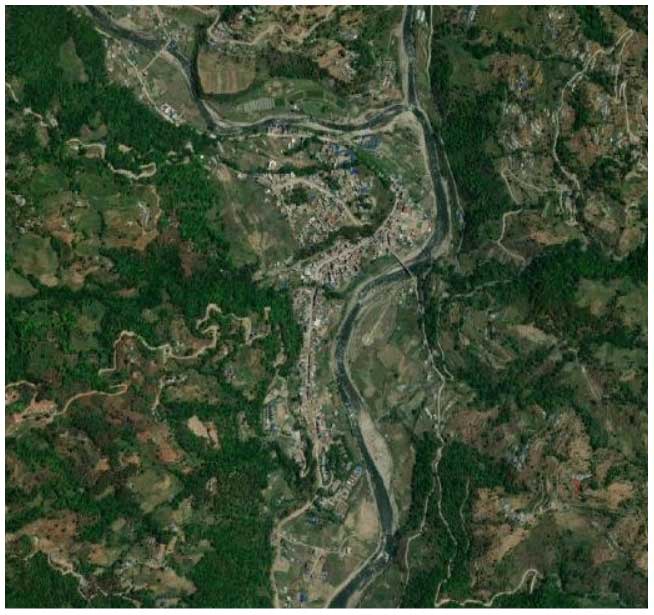
Figure 1Melamchi Bazar before the Flash Flood. Story Map Source: Created by Nepal Flying Labs using the Arc GIS Story Mapping tool by ESRI. A group of organizations (Nepal Flying Labs, Nepal Engineers' Association, Institute of Himalayan Risk Reduction, Geovation Nepal and NAXA).
After the outburst of the overstate flow of the river, the downstream settlements had been washed out with an unexpected disaster destroying the life and properties. It has a major impact on the livelihood, social-economic and lifeline of the people. The loss on the economy is immeasurable and impacts on daily life activities is also unpredictable. Approximately 985 359 m2 of land including the river flood plain area was covered with the debris (from drone survey data).
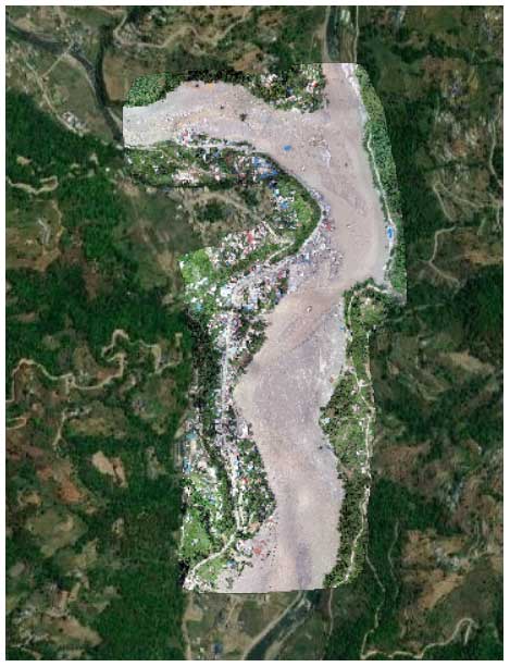
Figure 2Melamchi Bazar after the Flash Flood. Story Map Source: Created by Nepal Flying Labs using the Arc GIS Story Mapping tool by ESRI. A group of organizations (Nepal Flying Labs, Nepal Engineers' Association, Institute of Himalayan Risk Reduction, Geovation Nepal and NAXA).
4.2 Present Land Condition
Now, it is very important to carry out the detailed geological study of the location where the river changes its original course and flow in the new path. Huge quantity of debris also spread over the entire land deleting the past demarcation of the land boundary as shown in the Figs. 3 and 4. below. There are also major impacts on the land administration system of the Melamchi area changing the existing land use pattern with new challenges; two main types of land (i) river left barren land and (ii) registered land under the new river course flow. Three levels of government (i.e., Federal, Provincial and Local) should take the responsibilities to reclaim the land with the detail hydrological and geological studies of the location. Land reclaim project shall be created for necessary river protection and other infrastructure work along the bank of the river through the “Built Back Better” concept.
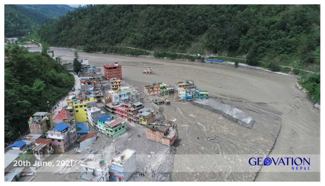
Figure 3Melamchi Bazar affected by the Flash Flood and flood plains from the drone survey (20 June 2021). Photo Source: Geovation, Nepal.
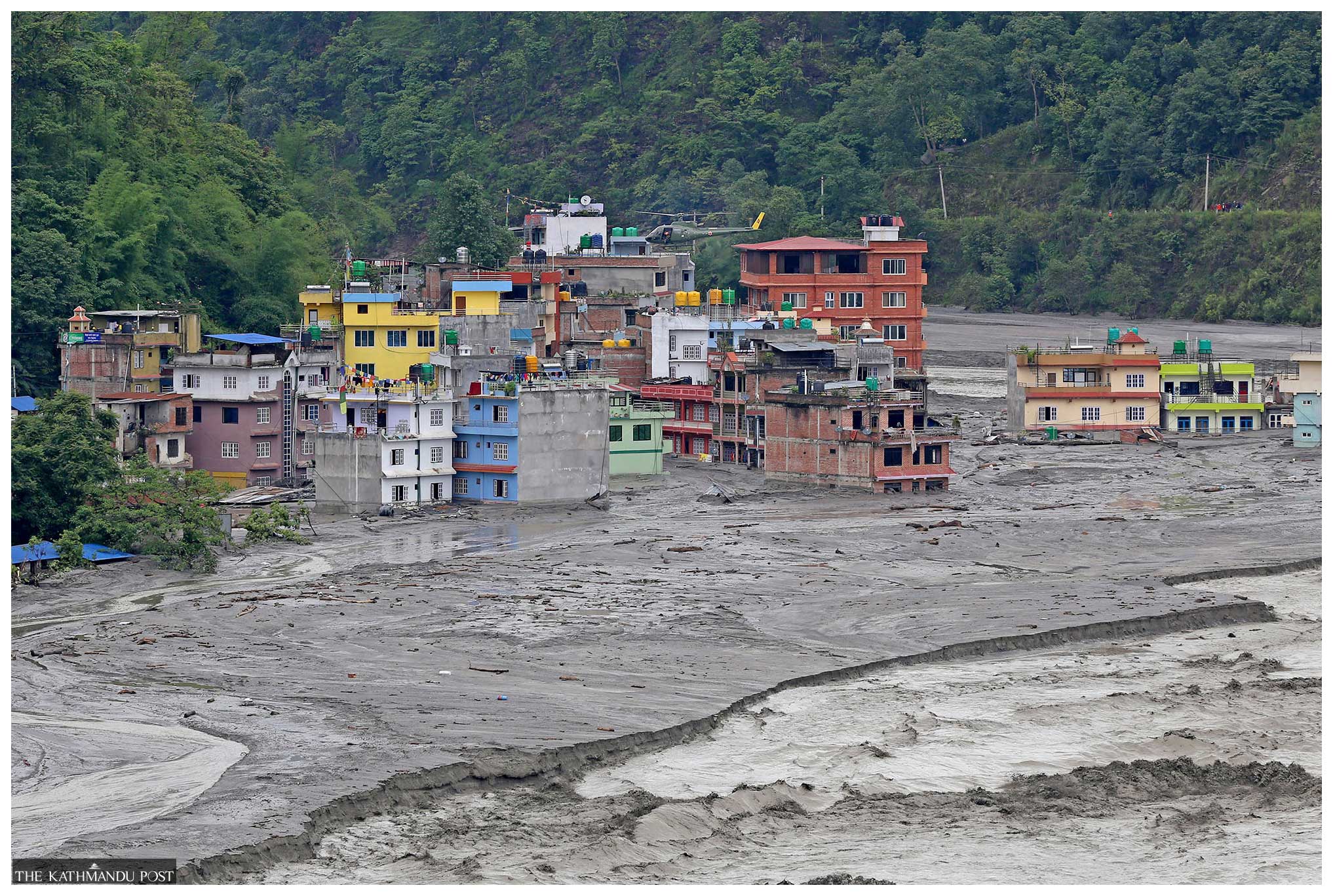
Figure 4Disaster encountered by Melamchi Bazar due to Flash Flood Photo Source: Kathmandu Post, Nepal.
Land readjustment planning is very important at this juncture of time because existing land demarcation is missing due to spatial change in the existing land use pattern after a devastating flash flood. The existing scenario of the area with the occupancy also drastically changed. At this time people of the affected area and local government should cooperate and support to cope with these problems. It can be solved through land readjustment planning, where marginal land can be managed for public utility space and optimum use of private land. The local government has to take the municipal council decision for Urban development planning concerning the participation of landowners and tenants. After approval of the Urban planning project from the concerned local body, shall publish a detailed notice in the national daily newspapers for the information of the general public.
A new cadastral survey should be conducted to prepare the updated land administration record of the privatively owned land of the citizens of the Melamchi area. According to the existing land use pattern and the land registration certificates, all information should be updated and the land acquisition process should be applied immediately. During this land acquisition time, people should be aware of the process and compensation will be in terms of the developed plot after deducting all the contribution percentage of land. Before instigating all these processes, the local government should conduct an orientation meeting with the land and property owners about the land readjustment (Land Pooling) system. The project's major objective shall be “no one should be left behind” with this benefit and “no one should be displaced” from the area. It also helps to consolidate the fragmented land into a single unit and it will easy to allocate such land in a particular location with the optimum use.
5.1 Provision of Land Development in Town Development Act 2045
The provision of land development in Town Development Act 1988 AD, the committee may operate the land development programs to manage existing land with the basic need of residents in a planned manner and with other township activities. To conduct the land readjustment project at least fifty-one percent of landowners or tenants of the project area should agree, which is mandatory and necessary. During the course of conducting land pooling program, the contribution from the land owner or tenants shall be based on the current monetary value of that land and existing road and other provided facilities in that area, to provide services and facilities such as road, drainage, open space, drinking water and electricity. To develop the sites the entire unit of lands shall be integrated into a single unit.
After fixing land contribution percent, the committee shall return developed plots to the former landowner or tenants along with provisional certificate within the period of mentioned timeline. After returning developed plots, the Committee shall write to the concerned Land Survey and Land Reform and Management Office for preparing the final survey map, maintaining the record of the landowner and for issuing land ownership registration certificate to the concerned landowner or tenants. After the preparation of the newly developed survey map, the record of the landowner, and the landowner registration certificate shall be updated, and the previous survey and entire previous inventory of the landowners and tenants of the concerned area shall be void.
Urban Flood Plain Rehabilitation Project shall be launched in such a highly urbanized and subject to frequent flooding area to develop flood plain. As per the present site condition of the land regarding the vulnerability it can be relocated residents and razed existing buildings. With the proper treatment as per the engineering consideration, the disaster-prone zone can be revitalized to restore the natural flow of the river. Besides other urban infrastructure facilities, the flood plain area can be integrated into parks, greenways along the river, and public recreation space. The flood plain area will be a function to provides storage with reducing stream velocities during large flood events. It also provides buffers zone area from flooding too. The river cross-section should be designed as per the existing hydrological dataset, providing three consecutive important factors considering the future use of land as follows.
- a.
Annual maximum floodway
- b.
Regulatory floodway (for 25 years of return period high flood level) and,
- c.
Standard Project Flood (SPF) limit (for 100 years of return period high flood level)
According to the above categories of the river section, standard zoning regulation such as Land Use Policy at municipal level shall be implemented on the use of flood plain areas. Regulatory floodway fringe use can be permitted for a selected use or otherwise protected it should be mentioned in the Building Byelaws. Standard Project Flood (SPF) limit area subject to possible flooding by very large floods with the 100 years of the return period. These types of areas can be restricted for the particularly important buildings of emergency uses, i.e., hospital, communication, security, etc. The studies show, there is a 1 % chance of occurrence for a 100 years flood event for any given year, and similarly, there is a 4 % chance of occurrence for a 25 years flood event.
The flash flood disaster destroyed the entire urban settlements along with the potential agricultural land on either side of the river converting into a barren flood plain filled with lots of debris. After every disaster there will be a golden period of renaissance for the spatial planning. After every disaster occurred it is very important to rescue the lives and properties of the people, then have to focus on the relief to those victims. After the relief of recent disaster events then they start on the search for loosed properties and belongings to survive for the future. Revitalization and recuperative treatment of the urban settlements are very important to invest in the reconstruction of major urban infrastructure with a planned urban development technique. Urban Flood Plain Restoration Project with a combined engineering and landscape design approach the restoration and enhancement of wetlands, creeks, and river corridors can be implemented.
Huge investment requires in the construction of raised road embankment and river levee. All types of urban utilities with proper recreational and public open spaces with public park maintaining the eco-system with a pleasant built environment needs to be incorporated. Land readjustment planning will definitely fulfill the demand for housing as well as commercial lots with a pleasant urban environment and meet the “Built Back Better” concept. Concerned authorities of the government of Nepal should give the proper attention to cope with the prevailing practice to redevelop the flash flood disaster destroyed urban settlements along the side of the river downstream. In this reference, the 4 “R” concept is an appropriate solution for a resilient urban environment with sustainable development after disaster events.
Nepal lies within the top twenty rank of multi-hazard countries as per the world ranking. The different types of hazards caused different types of disaster in different timelines. The disaster events can't be predicted but pre-information about meteorological transformation early alarm system may announce. The different time multi-hazard events have great impacts on the livelihood with a loss of lives and properties of the people. Disaster can't be controlled but if the mitigation measure will be applied it may reduce the chances and impacts of disaster.
Rural and urban municipalities settlements area are mostly seeming vulnerable due the flood and landslides disaster. Multi hazard risk assessment should be done for the municipalities for the investment in the safer location. Bank protection, erosion control, raised embankment with resilient physical urban infrastructures should be construct. After the flood disaster events 4 “R” approach i.e.; Reclaim of land, Readjustment of land, Rehabilitation and Reconstruction should be adopted for the sustainable development. It will definitely address the adaptation of disaster risk reduction and management for the victims. Therefore, the Government of Nepal should prepare the policy and program to minimize the risk. This types approach can be replicate in the other similar emerging market and urban centres to protect from the such disaster in the future. To formulate the national policy regarding the response, rescue, relief work including the rehabilitation and the reconstruction for the victims of the affected areas.
It is very important that each of the municipalities including Rural municipalities also have to prepare Risk Sensitive Land Use Plan (RSLUP) with the proper study of multi hazard risk assessment. Political leader must realize it, Federal and Provincial government should be enforced to all the local government to prepare and implement Risk Sensitive Land Use Plan.
The code and data used in this article are available at https://storymaps.arcgis.com/stories/5df39824b5604c80be8dfc429be93cfa (Nepal Flying Labs, 2021).
The author has declared that there are no competing interests.
Publisher’s note: Copernicus Publications remains neutral with regard to jurisdictional claims made in the text, published maps, institutional affiliations, or any other geographical representation in this paper. While Copernicus Publications makes every effort to include appropriate place names, the final responsibility lies with the authors.
This article is part of the special issue “ICFM9 – River Basin Disaster Resilience and Sustainability by All”. It is a result of The 9th International Conference on Flood Management, Tsukuba, Japan, 18–22 February 2023.
I would like to express my sincere gratitude to The 9th International Conference on Flood Management (ICFM9) on “River Basin Disaster Resilience and Sustainability by All – Integrated Flood Management in the Post COVID-19 Era” organized by International Centre for Water Hazard and Risk Management (ICHARM) under the Auspices of UNESCO, Public Works Research Institute (PWRI), Secretariate team encourage to submit article on the Catastrophic flood disaster of Melamchi Nepal on 16 June 2021, and allocating time for my presentation in the session 1 on 20 February 2023, to present my views on ICFM9.
I am also grateful to Editor-in chief Toshio Koike, Executive Director, ICHARM, and IAHS, Miho Ohara Guest editor, and anonymous reviewers for their valuable suggestion and creative inputs and funder IAHS for Post-conference publication in the PIAHS.
This research has been supported by the International Association of Hydrological Sciences (PIAHS grant).
This paper was edited by Miho Ohara and reviewed by two anonymous referees.
Collins, B. D. and Jibson, R. W.: Assessment of existing and potential landslide hazards resulting from the April 25, 2015 Gorkha, Nepal earthquake sequence (ver. 1.1, August 2015): U.S. Geological Survey Open-File Report 2015–1142, 50 pp., https://doi.org/10.3133/ofr20151142, 2015.
Ministry of Home Affairs (MoHA): Nepal Disaster Report, The Hazardscape and Vulnerability, Kathmandu Nepal, 2009.
Ministry of Home Affairs (MoHA): Nepal Disaster Report, Kathmandu Nepal, 2015.
Ministry of Home Affairs (MoHA): Nepal Disaster Report, 2017: The Road to Sendai, Kathmandu Government of Nepal, ISBN 978-9937-0-4217-8, 2018.
Nepal Flying Labs: Drone Based Rapid Assessment of Melamchi Flood 2021, https://storymaps.arcgis.com/stories/5df39824b5604c80be8dfc429be93cfa (last access: 14 July 2024), 2021.
Takamatsu, M., Karelia, H. D., Oommen, T., and Dahal, R. K.: Melamchi Flood Disaster in Nepal: Damage and Risk Quantification with Drone Survey, Satellite-Based Land Displacement Analysis, and 2D Flood Modeling, World Bank Group, Washington, D.C., http://documents.worldbank.org/curated/en/099600006212237293/P16057809e269a0cf096ab044bc77400259 (last access: 14 July 2024), 2021.
- Abstract
- Background
- Rationale and Uniqueness of 4 “R” Approach
- Government Policies and Program
- “R” Approach for Sustainable Urban Planning
- Readjustment of Land
- Rehabilitation
- Reconstruction
- Conclusion and recommendation
- Code and data availability
- Competing interests
- Disclaimer
- Special issue statement
- Acknowledgements
- Financial support
- Review statement
- References